-
Colour satellite image of Las Vegas, Nevada, USA. Image taken on September 23, 2014 with Landsat 8 data.
Rights-Managed
-
Satellite view of Las Vegas, Nevada, USA in 1975 and 2013. This before and after image shows urban expansion over the years.
Rights-Managed
-
Satellite view of Las Vegas, Nevada, USA in 1975, 2000 and 2013. This before and after image shows urban expansion over the years.
Rights-Managed
-
Colour satellite image of New Orleans, Louisiana, USA. Image taken on November 3, 2014 with Landsat 8 data.
Rights-Managed
-
Color satellite image of Las Vegas, Nevada, United States, with McCarran International Airport. Image collected on October 08, 2017 by Sentinel-2 satellites.
Rights-Managed
-
Color satellite image of Las Vegas, Nevada, United States. Image collected on October 08, 2017 by Sentinel-2 satellites.
Rights-Managed
-
Colour satellite image of New York City, New York State, USA. Image taken on July 31, 2014 with Landsat 8 data.
Rights-Managed
-
Colour satellite image of Los Angeles, California, USA. Image taken on October 23, 2014 with Landsat 8 data.
Rights-Managed
-
Colour satellite image of Detroit, Michigan, USA. Image taken on June 14, 2014 with Landsat 8 data.
Rights-Managed
-
Colour satellite image of Detroit, Michigan, USA. Image taken on June 14, 2014 with Landsat 8 data.
Rights-Managed
-
Colour satellite image of Chicago, Illinois, USA. Image taken on August 15, 2014 with Landsat 8 data.
Rights-Managed
-
Colour satellite image of Chicago, Illinois, USA. Image taken on August 15, 2014 with Landsat 8 data.
Rights-Managed
-
Colour satellite image of Asuncion, Paraguay. Image taken on September 21, 2014 with Landsat 8 data.
Rights-Managed
-
Colour satellite image of Pyongyang, North Korea. Image taken on June 6, 2014 with Landsat 8 data.
Rights-Managed
-
Colour satellite image of Paris, France. Image taken on May 19, 2014 with Landsat 8 data.
Rights-Managed
-
Colour satellite image of Cairo, Egypt. Image taken on December 16, 2013 with Landsat 8 data.
Rights-Managed
-
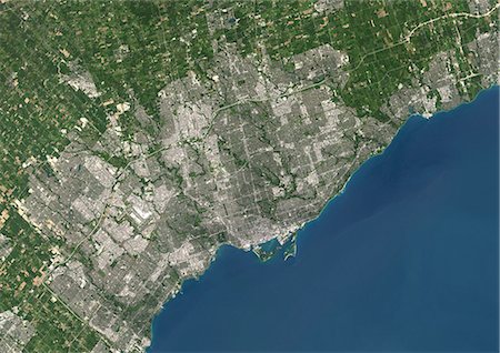
Colour satellite image of Toronto, Ontario, Canada. Image taken on August 19, 2014 with Landsat 8 data.
Rights-Managed
-
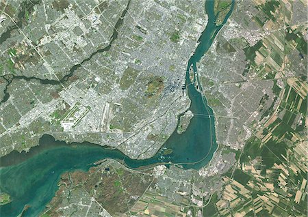
Colour satellite image of Montreal, Quebec, Canada. Image taken on November 11, 2014 with Landsat 8 data.
Rights-Managed
-
Colour satellite image of Montreal, Quebec, Canada. Image taken on November 11, 2014 with Landsat 8 data.
Rights-Managed
-
Colour satellite image of Tashkent, Uzbekistan. Image taken on August 28, 2014 with Landsat 8 data.
Rights-Managed
-
Colour satellite image of San Francisco and San Jose, United States. Image taken on July 24, 2014 with Landsat 8 data.
Rights-Managed
-
Colour satellite image of Miami, Florida, USA. Image taken on November 2, 2014 with Landsat 8 data.
Rights-Managed
-
Colour satellite image of Houston, Texas, USA. Image taken on May 16, 2014 with Landsat 8 data.
Rights-Managed
-
Colour satellite image of Zurich, Switzerland. Image taken on July 19, 2014 with Landsat 8 data.
Rights-Managed
-
Colour satellite image of Moscow, Russia. Image taken on April 21, 2014 with Landsat 8 data.
Rights-Managed
-
Color satellite image of Minneapolis, Minnesota, United States. The Mississippi River flows through the city. Minneapolis-Saint Paul International Airport is at south. Image collected on November 18, 2017 by Sentinel-2 satellites.
Rights-Managed
-
Color satellite image of Minneapolis, Minnesota, United States. The Mississippi River flows through the city. Image collected on November 18, 2017 by Sentinel-2 satellites.
Rights-Managed
-
Color satellite image of New Orleans, Louisiana, United States. The city is located in the Mississippi River Delta, south of Lake Pontchartrain, on the banks of the Mississippi River. Image collected on February 10, 2017 by Sentinel-2 satellites.
Rights-Managed
-
Color satellite image of New Orleans, Louisiana, United States. The city is located in the Mississippi River Delta, south of Lake Pontchartrain, on the banks of the Mississippi River. Image collected on February 10, 2017 by Sentinel-2 satellites.
Rights-Managed
-
Colour satellite image of Lisbon, Portugal. Image taken on July 9, 2014 with Landsat 8 data.
Rights-Managed
-
Colour satellite image of Karachi, Pakistan. Image taken on June 11, 2014 with Landsat 8 data.
Rights-Managed
-
Colour satellite image of Muscat, Oman. Image taken on December 27, 2013 with Landsat 8 data.
Rights-Managed
-
Colour satellite image of Lagos, Nigeria. Image taken on January 19, 2014 with Landsat 8 data.
Rights-Managed
-
Colour satellite image of Auckland, New Zealand. Image taken on February 9, 2014 with Landsat 8 data.
Rights-Managed
-
Colour satellite image of Rotterdam, Netherlands. Image taken on September 17, 2014 with Landsat 8 data.
Rights-Managed
-
Colour satellite image of Rotterdam, The Hague and Dordrecht, Netherlands. Image taken on September 17, 2014 with Landsat 8 data.
Rights-Managed
-
Colour satellite image of Amsterdam, Netherlands. Image taken on September 17, 2014 with Landsat 8 data.
Rights-Managed
-
Colour satellite image of Marrakesh, Morocco. Image taken on August 12, 2014 with Landsat 8 data.
Rights-Managed
-
Colour satellite image of Mexico City, Mexico. Image taken on December 14, 2013 with Landsat 8 data.
Rights-Managed
-
Colour satellite image of Berlin, Germany. Image taken on May 15, 2013 with Landsat 8 data.
Rights-Managed
-
Colour satellite image of Tallinn, Estonia. Image taken on July 25, 2014 with Landsat 8 data.
Rights-Managed
-
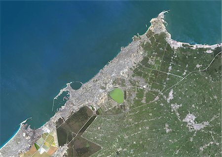
Colour satellite image of Alexandria, Egypt. Image taken on December 23, 2013 with Landsat 8 data.
Rights-Managed
-
Colour satellite image of Quito, Ecuador. Image taken on June 21, 2013 with Landsat 8 data.
Rights-Managed
-
Colour satellite image of Copenhagen, Denmark, and Malmo, Sweden. Image taken on September 5, 2014 with Landsat 8 data.
Rights-Managed
-
Colour satellite image of Tianjin and Binhai, China. Image taken on August 12, 2014 with Landsat 8 data.
Rights-Managed
-
Satellite view of Shanghai, China in 2001 and 2013. This before and after image shows urban expansion over the years.
Rights-Managed
-
Satellite view of Shanghai, China in 1979, 2001 and 2013. This before and after image shows urban expansion over the years.
Rights-Managed
-
Satellite view of Foshan and Guangzhou, China in 1990 and 2013. This before and after image shows urban expansion over the years.
Rights-Managed
-
Satellite view of Chengdu, China in 1992 and 2013. This before and after image shows urban expansion over the years.
Rights-Managed
-
Colour satellite image of Santiago, Chile. Image taken on January 9, 2014 with Landsat 8 data.
Rights-Managed
-
Colour satellite image of Greater Vancouver, British Colombia, Canada. Image taken on September 15, 2014 with Landsat 8 data.
Rights-Managed
-
Colour satellite image of Rio de Janeiro, Brazil. Image taken on October 24, 2014 with Landsat 8 data.
Rights-Managed
-
Satellite view of Rio de Janeiro, Brazil in 1975 and 2014. This before and after image shows urban expansion over the years.
Rights-Managed
-
Colour satellite image of Brasilia, Brazil. Image taken on October 4, 2014 with Landsat 8 data.
Rights-Managed
-
Colour satellite image of Sucre, Bolivia. Image taken on July 29, 2014 with Landsat 8 data.
Rights-Managed
-
Satellite view of Bahrain in 2002 and 2014. This before and after image shows urban expansion over the years.
Rights-Managed
-
Colour satellite image of Sydney, Australia. Image taken on August 4, 2014 with Landsat 8 data.
Rights-Managed
-
Colour satellite image of Melbourne, Australia. Image taken on January 30, 2014 with Landsat 8 data.
Rights-Managed
-
Colour satellite image of Brisbane, Australia. Image taken on October 7, 2014 with Landsat 8 data.
Rights-Managed
-
Colour satellite image of Adelaide, Australia. Image taken on August 29, 2014 with Landsat 8 data.
Rights-Managed
-
Colour satellite image of Buenos Aires City Center, Argentina. Image taken on November 17, 2014 with Landsat 8 data.
Rights-Managed
-
Colour satellite image of Buenos Aires, Argentina. Image taken on November 17, 2014 with Landsat 8 data.
Rights-Managed
-
Satellite view of the Aral Sea in 1990, 2000 and 2010. This image shows the shrinking of the Aral Sea over the years.
Rights-Managed
-
Colour satellite image of Luanda, Angola. Image taken on May 28, 2014 with Landsat 8 data.
Rights-Managed
-
Colour satellite image of Oran, Algeria. Image taken on September 1, 2014 with Landsat 8 data.
Rights-Managed
-
Colour satellite image of Algiers, Algeria. Image taken on July 17, 2014 with Landsat 8 data.
Rights-Managed
-
Colour satellite image of Kabul, Afghanistan. Image taken on September 6, 2014 with Landsat 8 data.
Rights-Managed
-
Satellite view of Mount St Helens, Washington, USA in 1972 and 1999. This image shows the volcano changes before and after its catastrophic eruption on May 18, 1980.
Rights-Managed
-
Colour satellite image of Dubai, United Arab Emirates. Image taken on December 25, 2013 with Landsat 8 data.
Rights-Managed
-
Satellite view of Dubai, United Arab Emirates in 2000, 2005 and 2010. This before and after image shows urban expansion over the years and the construction of the World Islands and the Palm island called Palm Jumeirah.
Rights-Managed
-
Colour satellite image of Abu Dhabi, United Arab Emirates. Image taken on December 16, 2013 with Landsat 8 data.
Rights-Managed
-
Satellite view of Abu Dhabi, United Arab Emirates in 1985 and 2014. This before and after image shows urban expansion over the years.
Rights-Managed
-
Colour satellite image of Istanbul, Turkey. Image taken on July 30, 2013 with Landsat 8 data.
Rights-Managed
-
Colour satellite image of Phuket, Thailand. Image taken on February 25, 2014 with Landsat 8 data.
Rights-Managed
-
Colour satellite image of Bangkok, Thailand. Image taken on February 2, 2014 with Landsat 8 data.
Rights-Managed
-
Colour satellite image of Singapore, Singapore. Image taken on May 13, 2014 with Landsat 8 data.
Rights-Managed
-
Colour satellite image of Lisbon, Portugal. Image taken on July 9, 2014 with Landsat 8 data.
Rights-Managed
-
Color satellite image of Lake Superior, North America. Image collected on May 1, 2016 by Landsat 8 satellite.
Rights-Managed
-
Color satellite image of Lake Ontario, North America. Image collected on May 1, 2016 by Landsat 8 satellite.
Rights-Managed
-
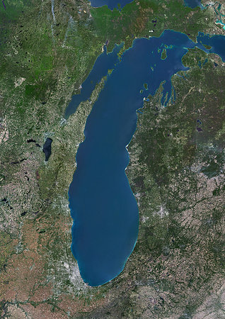
Color satellite image of Lake Michigan, United States. Image collected on May 1, 2016 by Landsat 8 satellite.
Rights-Managed
-
Color satellite image of Lake Huron, North America. Image collected on May 1, 2016 by Landsat 8 satellite.
Rights-Managed
-
Color satellite image of Lake Erie, North America. Image collected on May 1, 2016 by Landsat 8 satellite.
Rights-Managed
-
Color satellite image of Seattle, Washington, United States. It is a seaport city located between the Puget Sound to the west and Lake Washington to the east. Image collected on August 31, 2017 by Sentinel-2 satellites.
Rights-Managed
-
Color satellite image of Seattle, Washington, United States. It is a seaport city located between the Puget Sound to the west and Lake Washington to the east. Image collected on August 31, 2017 by Sentinel-2 satellites.
Rights-Managed
-
Color satellite image of Portland, Oregon, United States. The city lies at the confluence of the Willamette and Columbia Rivers. Image collected on August 31, 2017 by Sentinel-2 satellites.
Rights-Managed
-
Color satellite image of Portland, Oregon, United States. The city lies at the confluence of the Willamette and Columbia Rivers. Image collected on August 31, 2017 by Sentinel-2 satellites.
Rights-Managed
-
Color satellite image of Phoenix, Arizona, United States. Image collected on March 9, 2018 by Sentinel-2 satellites.
Rights-Managed
-
Color satellite image of Philadelphia, Pennsylvania, United States The city is located along the Delaware and Schuylkill Rivers. Image collected on September 23, 2017 by Sentinel-2 satellites.
Rights-Managed
-
Color satellite image of Philadelphia, Pennsylvania, United States The city is located along the Delaware and Schuylkill Rivers. Image collected on September 23, 2017 by Sentinel-2 satellites.
Rights-Managed
-
Color satellite image of Orlando, Florida, United States. Image collected on February 18, 2018 by Sentinel-2 satellites.
Rights-Managed


