-

Satellite view of deforestation in Matto Grosso, Brazil in 1985 and 2000. This before and after image shows deforestation impact over the years.
Con derechos protegidos
-

Satellite view of deforestation in East Rondonia, Brazil in 1986 and 2001. This before and after image shows deforestation impact over the years.
Con derechos protegidos
-

Color satellite image of the Amazon Delta, Brazil. Image collected by Landsat satellites.
Con derechos protegidos
-

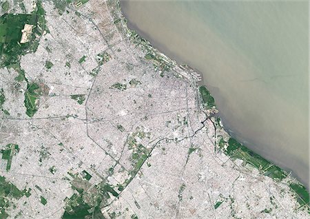
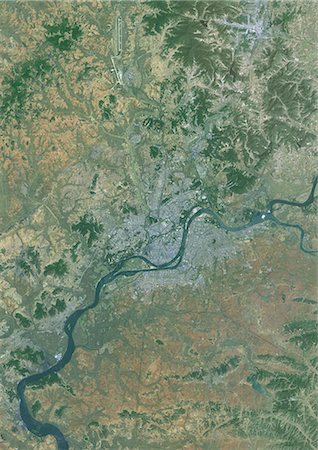
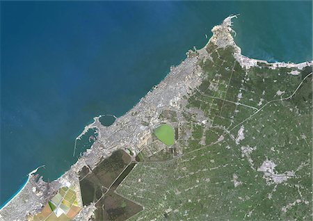
Colour satellite image of Rio de Janeiro, Brazil. Image taken on October 24, 2014 with Landsat 8 data.
Con derechos protegidos
-
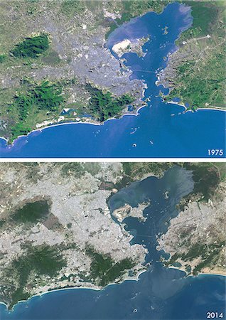
Satellite view of Rio de Janeiro, Brazil in 1975 and 2014. This before and after image shows urban expansion over the years.
Con derechos protegidos
-

Colour satellite image of Brasilia, Brazil. Image taken on October 4, 2014 with Landsat 8 data.
Con derechos protegidos
-
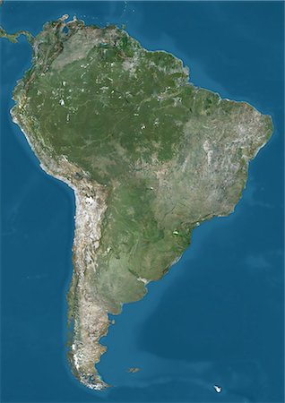
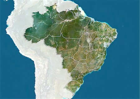
Satellite view of South America. This image was compiled from data acquired by Landsat 7 & 8 satellites.
Con derechos protegidos
-
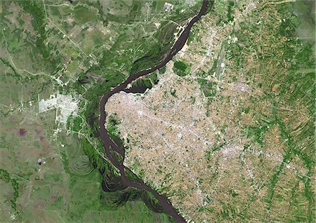
Colour satellite image of Asuncion, Paraguay. Image taken on September 21, 2014 with Landsat 8 data.
Con derechos protegidos
-

Colour satellite image of Quito, Ecuador. Image taken on June 21, 2013 with Landsat 8 data.
Con derechos protegidos
-
Colour satellite image of Santiago, Chile. Image taken on January 9, 2014 with Landsat 8 data.
Con derechos protegidos
-

Colour satellite image of Sucre, Bolivia. Image taken on July 29, 2014 with Landsat 8 data.
Con derechos protegidos
-
Colour satellite image of Buenos Aires City Center, Argentina. Image taken on November 17, 2014 with Landsat 8 data.
Con derechos protegidos
-

Colour satellite image of Buenos Aires, Argentina. Image taken on November 17, 2014 with Landsat 8 data.
Con derechos protegidos
-
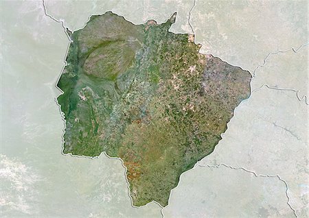
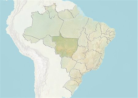
Satellite view of the State of Mato Grosso do Sul, Brazil. This image was compiled from data acquired by LANDSAT 5 & 7 satellites.
Con derechos protegidos
-
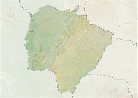
Relief map of the State of Mato Grosso do Sul, Brazil. This image was compiled from data acquired by LANDSAT 5 & 7 satellites combined with elevation data.
Con derechos protegidos
-
-

-

Brazil and the State of Mato Grosso, True Colour Satellite Image
Con derechos protegidos
-
-

Deforestation, West Rondonia, Brazil, In 2000, True Colour Satellite Image. True colour satellite image showing deforestation in Amazonia in the Western part of the State of Rondonia, Brazil. Image taken on 22 August 2000, using LANDSAT data.
Con derechos protegidos
-

Deforestation, West Rondonia, Brazil, In 1986, True Colour Satellite Image. True colour satellite image showing deforestation in Amazonia in the Western part of the State of Rondonia, Brazil. Image taken on 07 July 1986, using LANDSAT data.
Con derechos protegidos
-

Deforestation, East Rondonia, Brazil, In 2001, True Colour Satellite Image. True colour satellite image showing deforestation in Amazonia in the Eastern part of the State of Rondonia, Brazil. Image in portrait format taken in 2001, using LANDSAT data.
Con derechos protegidos
-

Deforestation, East Rondonia, Brazil, In 1986, True Colour Satellite Image. True colour satellite image showing deforestation in Amazonia in the Eastern part of the State of Rondonia, Brazil. Image in portrait format taken in 1986, using LANDSAT data.
Con derechos protegidos
-

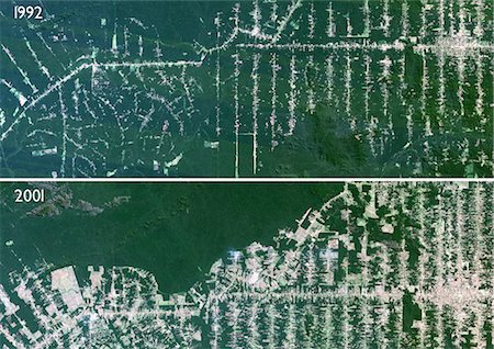
Deforestation, East Rondonia, Brazil, In 2000, True Colour Satellite Image. True colour satellite image showing deforestation in Amazonia in the Eastern part of the State of Rondonia, Brazil. Image in landscape format taken in 2000, using LANDSAT data.
Con derechos protegidos
-

Deforestation, East Rondonia, Brazil, In 1990, True Colour Satellite Image. True colour satellite image showing deforestation in Amazonia in the Eastern part of the State of Rondonia, Brazil. Image in landscape format taken in 1990, using LANDSAT data.
Con derechos protegidos
-
Deforestation, Para, Brazil, In 2000, True Colour Satellite Image. True colour satellite image showing deforestation in Amazonia in the State of Para, Brazil. Image taken in 2000, using LANDSAT data.
Con derechos protegidos
-

Deforestation, Para, Brazil, In 1992, True Colour Satellite Image. True colour satellite image showing deforestation in Amazonia in the State of Para, Brazil. Image taken in 1992, using LANDSAT data.
Con derechos protegidos
-

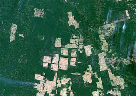
Deforestation, Mato Grosso, Brazil, In 2000, True Colour Satellite Image. True colour satellite image showing deforestation in Amazonia in the State of Mato Grosso, Brazil. Image taken on 18 June 2000, using LANDSAT data.
Con derechos protegidos
-

Deforestation, Mato Grosso, Brazil, In 1985, True Colour Satellite Image. True colour satellite image showing deforestation in Amazonia in the State of Mato Grosso, Brazil. Image taken on 17 June 1985, using LANDSAT data.
Con derechos protegidos
-

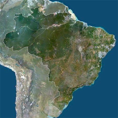
Brazil, South America, True Colour Satellite Image With Mask. Satellite view of Brazil (with mask), print size 42x42cm. This image was compiled from data acquired by LANDSAT 5 & 7 satellites.
Con derechos protegidos
-
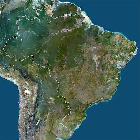
Brazil, South America, True Colour Satellite Image With Border And Mask. Satellite view of Brazil (with border and mask), print size 42x42cm. This image was compiled from data acquired by LANDSAT 5 & 7 satellites.
Con derechos protegidos
-
Brazil, South America, True Colour Satellite Image With Border. Satellite view of Brazil (with border), print size 42x42cm. This image was compiled from data acquired by LANDSAT 5 & 7 satellites.
Con derechos protegidos
-
Deforestation, Mato Grosso, Brazil, True Colour Satellite Image. True colour satellite image showing deforestation in progress between 1992 and 2001 in Amazonia in the State of Mato Grosso, using LANDSAT data.
Con derechos protegidos
-

Colour satellite image of Lisbon, Portugal. Image taken on July 9, 2014 with Landsat 8 data.
Con derechos protegidos
-

Colour satellite image of Karachi, Pakistan. Image taken on June 11, 2014 with Landsat 8 data.
Con derechos protegidos
-

Colour satellite image of Muscat, Oman. Image taken on December 27, 2013 with Landsat 8 data.
Con derechos protegidos
-
Colour satellite image of Pyongyang, North Korea. Image taken on June 6, 2014 with Landsat 8 data.
Con derechos protegidos
-

Colour satellite image of Lagos, Nigeria. Image taken on January 19, 2014 with Landsat 8 data.
Con derechos protegidos
-

Colour satellite image of Auckland, New Zealand. Image taken on February 9, 2014 with Landsat 8 data.
Con derechos protegidos
-
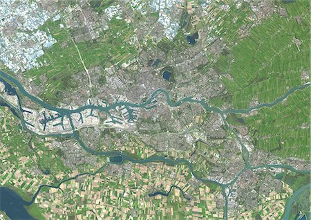
Colour satellite image of Rotterdam, Netherlands. Image taken on September 17, 2014 with Landsat 8 data.
Con derechos protegidos
-

Colour satellite image of Rotterdam, The Hague and Dordrecht, Netherlands. Image taken on September 17, 2014 with Landsat 8 data.
Con derechos protegidos
-

Colour satellite image of Amsterdam, Netherlands. Image taken on September 17, 2014 with Landsat 8 data.
Con derechos protegidos
-

Colour satellite image of Marrakesh, Morocco. Image taken on August 12, 2014 with Landsat 8 data.
Con derechos protegidos
-

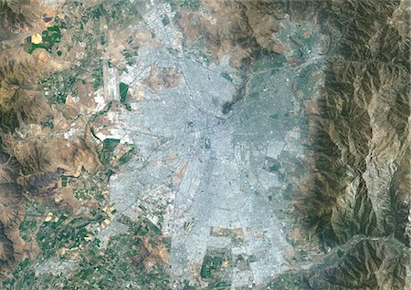
Colour satellite image of Mexico City, Mexico. Image taken on December 14, 2013 with Landsat 8 data.
Con derechos protegidos
-
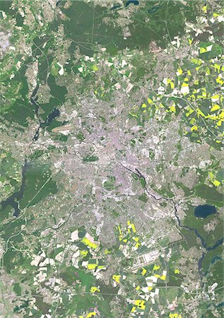
Colour satellite image of Berlin, Germany. Image taken on May 15, 2013 with Landsat 8 data.
Con derechos protegidos
-

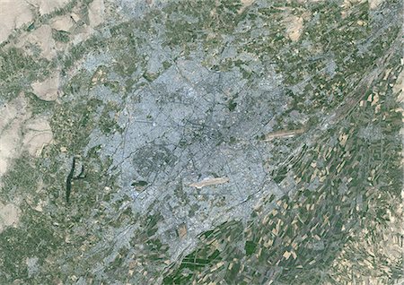
Colour satellite image of Paris, France. Image taken on May 19, 2014 with Landsat 8 data.
Con derechos protegidos
-

Colour satellite image of Tallinn, Estonia. Image taken on July 25, 2014 with Landsat 8 data.
Con derechos protegidos
-

Colour satellite image of Cairo, Egypt. Image taken on December 16, 2013 with Landsat 8 data.
Con derechos protegidos
-
Colour satellite image of Alexandria, Egypt. Image taken on December 23, 2013 with Landsat 8 data.
Con derechos protegidos
-

Colour satellite image of Copenhagen, Denmark, and Malmo, Sweden. Image taken on September 5, 2014 with Landsat 8 data.
Con derechos protegidos
-

Colour satellite image of Tianjin and Binhai, China. Image taken on August 12, 2014 with Landsat 8 data.
Con derechos protegidos
-

Satellite view of Shanghai, China in 2001 and 2013. This before and after image shows urban expansion over the years.
Con derechos protegidos
-

Satellite view of Shanghai, China in 1979, 2001 and 2013. This before and after image shows urban expansion over the years.
Con derechos protegidos
-

Satellite view of Foshan and Guangzhou, China in 1990 and 2013. This before and after image shows urban expansion over the years.
Con derechos protegidos
-

Satellite view of Chengdu, China in 1992 and 2013. This before and after image shows urban expansion over the years.
Con derechos protegidos
-

Colour satellite image of Greater Vancouver, British Colombia, Canada. Image taken on September 15, 2014 with Landsat 8 data.
Con derechos protegidos
-
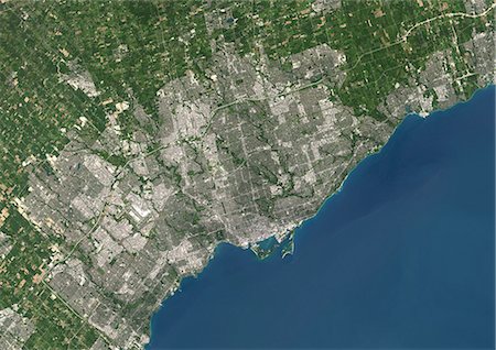
Colour satellite image of Toronto, Ontario, Canada. Image taken on August 19, 2014 with Landsat 8 data.
Con derechos protegidos
-
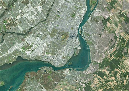
Colour satellite image of Montreal, Quebec, Canada. Image taken on November 11, 2014 with Landsat 8 data.
Con derechos protegidos
-

Colour satellite image of Montreal, Quebec, Canada. Image taken on November 11, 2014 with Landsat 8 data.
Con derechos protegidos
-

Satellite view of Bahrain in 2002 and 2014. This before and after image shows urban expansion over the years.
Con derechos protegidos
-
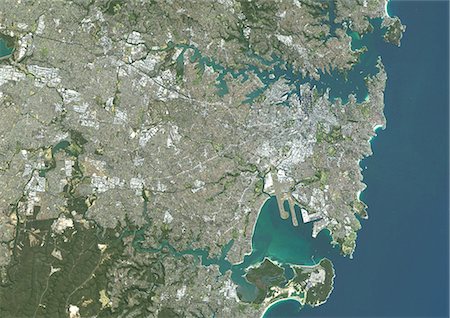
Colour satellite image of Sydney, Australia. Image taken on August 4, 2014 with Landsat 8 data.
Con derechos protegidos
-

Colour satellite image of Melbourne, Australia. Image taken on January 30, 2014 with Landsat 8 data.
Con derechos protegidos
-

Colour satellite image of Brisbane, Australia. Image taken on October 7, 2014 with Landsat 8 data.
Con derechos protegidos
-

Colour satellite image of Adelaide, Australia. Image taken on August 29, 2014 with Landsat 8 data.
Con derechos protegidos
-
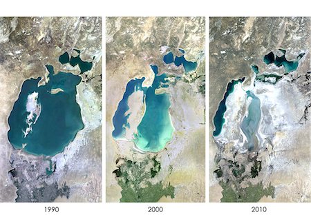
Satellite view of the Aral Sea in 1990, 2000 and 2010. This image shows the shrinking of the Aral Sea over the years.
Con derechos protegidos
-

Colour satellite image of Luanda, Angola. Image taken on May 28, 2014 with Landsat 8 data.
Con derechos protegidos
-

Colour satellite image of Oran, Algeria. Image taken on September 1, 2014 with Landsat 8 data.
Con derechos protegidos
-
Colour satellite image of Algiers, Algeria. Image taken on July 17, 2014 with Landsat 8 data.
Con derechos protegidos
-

Colour satellite image of Kabul, Afghanistan. Image taken on September 6, 2014 with Landsat 8 data.
Con derechos protegidos
-
-

-
-
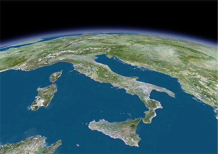
3D satellite image of Italy, showing Sicily, Sardinia and Corsica.
Con derechos protegidos
-

-

-
-

-
-
-

-

-

-
Colour satellite image of Tashkent, Uzbekistan. Image taken on August 28, 2014 with Landsat 8 data.
Con derechos protegidos
-

Colour satellite image of San Francisco and San Jose, United States. Image taken on July 24, 2014 with Landsat 8 data.
Con derechos protegidos
-
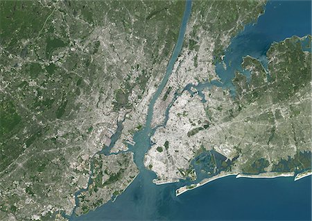
Colour satellite image of New York City, New York State, USA. Image taken on July 31, 2014 with Landsat 8 data.
Con derechos protegidos
-

Colour satellite image of New Orleans, Louisiana, USA. Image taken on November 3, 2014 with Landsat 8 data.
Con derechos protegidos
-
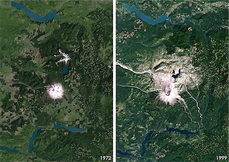
Satellite view of Mount St Helens, Washington, USA in 1972 and 1999. This image shows the volcano changes before and after its catastrophic eruption on May 18, 1980.
Con derechos protegidos
-

Colour satellite image of Miami, Florida, USA. Image taken on November 2, 2014 with Landsat 8 data.
Con derechos protegidos
-

Colour satellite image of Los Angeles, California, USA. Image taken on October 23, 2014 with Landsat 8 data.
Con derechos protegidos
-

Colour satellite image of Las Vegas, Nevada, USA. Image taken on September 23, 2014 with Landsat 8 data.
Con derechos protegidos


