-

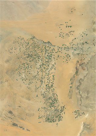
Agriculture In The Desert, City Of Tabuk In 2001, Saudi Arabia, True Colour Satellite Image. True colour satellite image of the city of Tabuk in 2001, in north western Saudi Arabia. Circular agricultural plots are visible on the image. Composite image using LANDSAT 7 data.
Con derechos protegidos
-

Agriculture In The Desert, City Of Tabuk In 1990, Saudi Arabia, True Colour Satellite Image. True colour satellite image of the city of Tabuk in 1990, in north western Saudi Arabia. Circular agricultural plots are visible on the image. Composite image using LANDSAT 5 data.
Con derechos protegidos
-
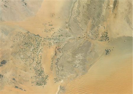
Agriculture In The Desert, South Part Of The Riyadh Province, Saudi Arabia, True Colour Satellite Image. True colour satellite image of agriculture in the desert in Saudi Arabia. The image shows the south part of the Riyadh Province, about 500 km south of Riyadh. Circular agricultural plots are visible on the image. Composite image from 2001, using LANDSAT 7 data.
Con derechos protegidos
-

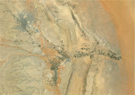
Topographic Map of Al Sulail, South Part Of The Riyadh Province, Saudi Arabia
Con derechos protegidos
-
Agriculture In The Desert, South Part Of The Riyadh Province, Saudi Arabia, True Colour Satellite Image. True colour satellite image of agriculture in the desert in Saudi Arabia. The image shows the south part of the Riyadh Province, about 500 km south of Riyadh. Circular agricultural plots are visible on the image. Composite image from 2001, using LANDSAT 7 data.
Con derechos protegidos
-

Agriculture In The Desert In 2006, Saudi Arabia, True Colour Satellite Image. True colour satellite image of agriculture in the desert, about 250 km west of the Saudi capital, Riyadh. Circular agricultural plots are visible on the image. Composite image taken in 2006, using LANDSAT 5 data.
Con derechos protegidos
-
Agriculture In The Desert In 2001, Saudi Arabia, True Colour Satellite Image. True colour satellite image of agriculture in the desert, about 250 km west of the Saudi capital, Riyadh. Circular agricultural plots are visible on the image. Composite image taken in 2001, using LANDSAT 5 data.
Con derechos protegidos
-

Agriculture In The Desert In 1998, Saudi Arabia, True Colour Satellite Image. True colour satellite image of agriculture in the desert, about 250 km west of the Saudi capital, Riyadh. Circular agricultural plots are visible on the image. Composite image taken in 1998, using LANDSAT 5 data.
Con derechos protegidos
-

Agriculture In The Desert, Al-Qassim Province, Saudi Arabia, True Colour Satellite Image. True colour satellite image of agriculture in the desert, north of the Saudi cities of Buraydah and Unaizah (bottom right), in the Al-Qassim Province, Saudi Arabia. Circular agricultural plots are visible on the image. Composite image using LANDSAT 7 data.
Con derechos protegidos
-
Riyadh, Saudi Arabia , True Colour Satellite Image. True colour satellite image of Riyadh, the capital and largest city of Saudi Arabia. Circular agricultural plots are visible southeast of Riyadh. Composite image using LANDSAT 7 data.
Con derechos protegidos
-

Agriculture In The Desert, Riyadh Province, Saudi Arabia, True Colour Satellite Image. True colour satellite image of agriculture in the desert in the Riyadh Province, Saudi Arabia, about 250 km west of the Saudi capital, Riyadh. Circular agricultural plots are visible on the image. Composite image using LANDSAT 7 data.
Con derechos protegidos
-
-

Agriculture In The Libyan Desert, Libya, True Colour Satellite Image. True colour satellite image of agriculture in the Libyan desert in 2001, in the eastern part of Libya. Circular agricultural plots are visible on the image. Composite image using LANDSAT 7 data.
Con derechos protegidos
-

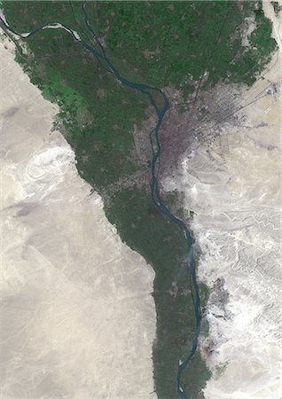
Nile Delta, Egypt, True Colour Satellite Image. True colour satellite image of the Nile Delta. It is formed in Northern Egypt where the Nile River spreads out and drains into the Mediterranean Sea. This swamp region has always been rich in fauna and flora, contrasting with the surrounding desert. Image taken on 23 August 2000 using LANDSAT data.
Con derechos protegidos
-
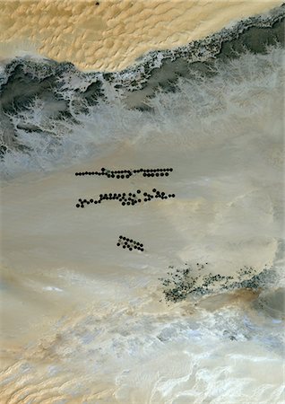
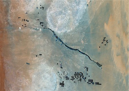
Agriculture In The Murzuq Desert In 2005, Libya, True Colour Satellite Image. True colour satellite image of agriculture in the northern Murzuq Desert in Libya. The Murzuq Desert is an erg desert, part of the Sahara desert, in southwestern Libya. Circular agricultural plots are visible on the image. Image taken on 11 March 2005, using LANDSAT 7 data.
Con derechos protegidos
-

Agriculture In The Murzuq Desert In 2000, Libya, True Colour Satellite Image. True colour satellite image of agriculture in the northern Murzuq Desert in Libya. The Murzuq Desert is an erg desert, part of the Sahara desert, in southwestern Libya. Circular agricultural plots are visible on the image. Image taken on 8 November 2000, using LANDSAT 7 data.
Con derechos protegidos
-
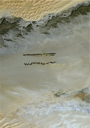
Agriculture In The Murzuq Desert In 1987, Libya, True Colour Satellite Image. True colour satellite image of agriculture in the northern Murzuq Desert in Libya. The Murzuq Desert is an erg desert, part of the Sahara desert, in southwestern Libya. Circular agricultural plots are visible on the image. Image taken on 13 January 1987, using LANDSAT 5 data.
Con derechos protegidos
-
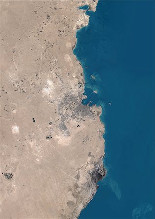
Doha, Qatar, True Colour Satellite Image. True colour satellite image of Doha, the capital city of Qatar, located on the Persian Gulf. Image taken in August 2001, using LANDSAT 7 data.
Con derechos protegidos
-
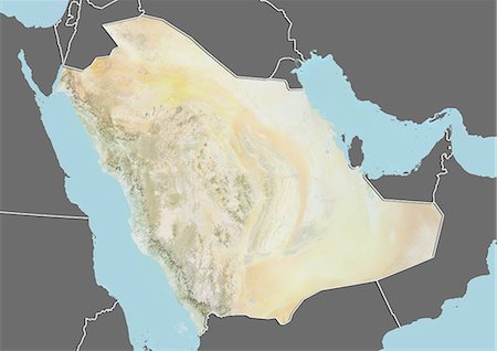
Saudi Arabia, Middle East, Asia, True Colour Satellite Image With Mask. Satellite view of Saudi Arabia (with mask). This image was compiled from data acquired by LANDSAT 5 & 7 satellites.
Con derechos protegidos
-
Saudi Arabia, Middle East, Asia, True Colour Satellite Image With Border And Mask. Satellite view of Saudi Arabia (with border and mask). This image was compiled from data acquired by LANDSAT 5 & 7 satellites.
Con derechos protegidos
-
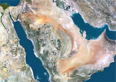
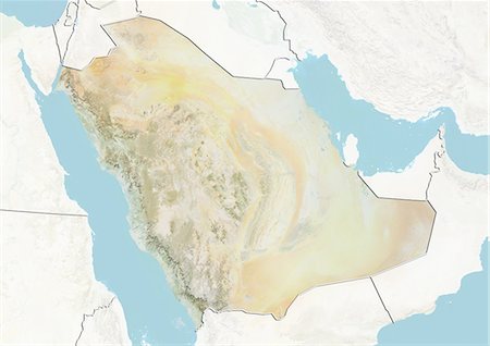
Saudi Arabia, Middle East, True Colour Satellite Image With Border. Satellite view of Saudi Arabia (with border). This image was compiled from data acquired by LANDSAT 5 & 7 satellites.
Con derechos protegidos
-

-
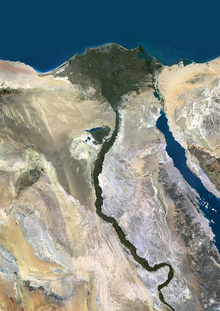
Color satellite image of the Nile River, Egypt. The Nile Delta is formed in Northern Egypt where the Nile River spreads out and drains into the Mediterranean Sea. Images collected on October 1, 2017 by Landsat 8 satellite.
Con derechos protegidos
-

Color satellite image of the Nile Delta. It is formed in Northern Egypt where the Nile River spreads out and drains into the Mediterranean Sea. Image collected on October 1, 2017 by Sentinel-2 satellites.
Con derechos protegidos
-
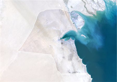
Kuwait, True Colour Satellite Image With Mask And Border. Kuwait, true colour satellite image with mask and border. North of the image, the Shatt al Arab river flows into the Persian Gulf. Kuwait City (center) is the capital city of Kuwait. This image was compiled from data acquired by LANDSAT 5 & 7 satellites.
Con derechos protegidos
-

Kuwait, True Colour Satellite Image With Border. Kuwait, true colour satellite image with border. North of the image, the Shatt al Arab river flows into the Persian Gulf. Kuwait City (center) is the capital city of Kuwait. This image was compiled from data acquired by LANDSAT 5 & 7 satellites.
Con derechos protegidos
-

-

-
-

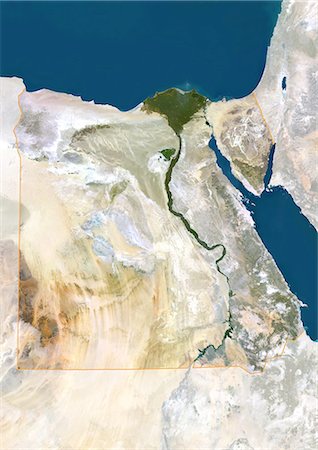
Egypt, True Colour Satellite Image With Border. Egypt, true colour satellite image with border. North is at top. In the center of the image is the Nile Delta, its lush vegetation following the path of the river. To the east of the Nile is the Gulf of Suez, which runs down the western side of the Sinai Peninsula. This image was compiled from data acquired by LANDSAT 5 & 7 satellites.
Con derechos protegidos
-

Afghanistan, True Colour Satellite Image With Mask And Border. Afghanistan, true colour satellite image with mask and border. North is at top. Much of Afghanistan is mountainous, over half being at elevations of over 2000 metres. Deserts and rocky plains are also extensive. This image was compiled from data acquired by LANDSAT 5 & 7 satellites.
Con derechos protegidos
-

Afghanistan, True Colour Satellite Image With Border. Afghanistan, true colour satellite image with border. North is at top. Much of Afghanistan is mountainous, over half being at elevations of over 2000 metres. Deserts and rocky plains are also extensive. This image was compiled from data acquired by LANDSAT 5 & 7 satellites.
Con derechos protegidos
-

Yemen, Middle East, Asia, True Colour Satellite Image With Mask. Satellite view of Yemen (with mask). This image was compiled from data acquired by LANDSAT 5 & 7 satellites.
Con derechos protegidos
-

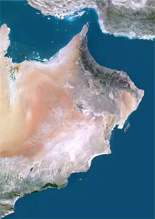
Oman, Middle East, Asia, True Colour Satellite Image With Mask. Satellite view of Oman (with mask). This image was compiled from data acquired by LANDSAT 5 & 7 satellites.
Con derechos protegidos
-

Jordan, Middle East, Asia, True Colour Satellite Image With Mask. Satellite view of Jordan (with mask). This image was compiled from data acquired by LANDSAT 5 & 7 satellites.
Con derechos protegidos
-
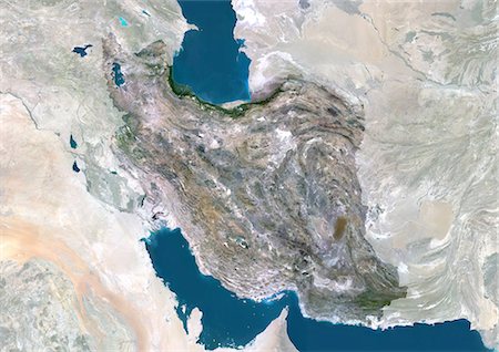
Iran, Middle East, Asia, True Colour Satellite Image With Mask. Satellite view of Iran (with mask). This image was compiled from data acquired by LANDSAT 5 & 7 satellites.
Con derechos protegidos
-
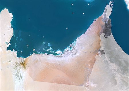
United Arab Emirates, Middle East, Asia, True Colour Satellite Image With Mask. Satellite view of United Arab Emirates (with mask). This image was compiled from data acquired by LANDSAT 5 & 7 satellites.
Con derechos protegidos
-

Yemen, Middle East, Asia, True Colour Satellite Image With Border And Mask. Satellite view of Yemen (with border and mask). This image was compiled from data acquired by LANDSAT 5 & 7 satellites.
Con derechos protegidos
-

Yemen, Middle East, Asia, True Colour Satellite Image With Border. Satellite view of Yemen (with border and mask). This image was compiled from data acquired by LANDSAT 5 & 7 satellites.
Con derechos protegidos
-

Qatar, Middle East, Asia, True Colour Satellite Image With Border. Satellite view of Qatar (with border). This image was compiled from data acquired by LANDSAT 5 & 7 satellites.
Con derechos protegidos
-

Oman, Middle East, Asia, True Colour Satellite Image With Border And Mask. Satellite view of Oman (with border and mask). This image was compiled from data acquired by LANDSAT 5 & 7 satellites.
Con derechos protegidos
-
Oman, Middle East, Asia, True Colour Satellite Image With Border. Satellite view of Oman (with border). This image was compiled from data acquired by LANDSAT 5 & 7 satellites.
Con derechos protegidos
-

Jordan, Middle East, Asia, True Colour Satellite Image With Border And Mask. Satellite view of Jordan (with border and mask). This image was compiled from data acquired by LANDSAT 5 & 7 satellites.
Con derechos protegidos
-

Jordan, Middle East, Asia, True Colour Satellite Image With Border. Satellite view of Jordan (with border). This image was compiled from data acquired by LANDSAT 5 & 7 satellites.
Con derechos protegidos
-

Iran, Middle East, Asia, True Colour Satellite Image With Border And Mask. Satellite view of Iran (with border and mask). This image was compiled from data acquired by LANDSAT 5 & 7 satellites.
Con derechos protegidos
-

Iran, Middle East, Asia, True Colour Satellite Image With Border. Satellite view of Iran (with border). This image was compiled from data acquired by LANDSAT 5 & 7 satellites.
Con derechos protegidos
-

United Arab Emirates, Middle East, Asia, True Colour Satellite Image With Border And Mask. Satellite view of United Arab Emirates (with border and mask). This image was compiled from data acquired by LANDSAT 5 & 7 satellites.
Con derechos protegidos
-

United Arab Emirates, Middle East, Asia, True Colour Satellite Image With Border. Satellite view of United Arab Emirates (with border). This image was compiled from data acquired by LANDSAT 5 & 7 satellites.
Con derechos protegidos
-
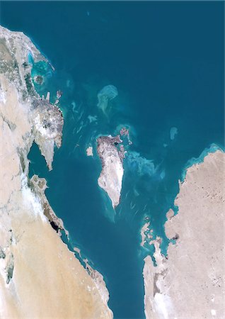
Bahrain, Middle East, Asia, True Colour Satellite Image. Satellite view of Bahrain . This image was compiled from data acquired by LANDSAT 5 & 7 satellites.
Con derechos protegidos
-
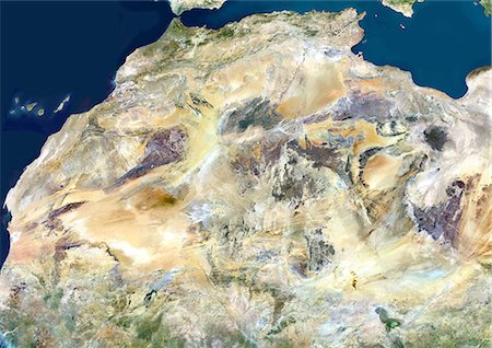
Sahara Desert, Africa, True Colour Satellite Image. Sahara desert, true colour satellite image. The Sahara is the world's largest hot desert, made of sand and volcanic mountains. Composite image using data from LANDSAT 5 & 7 satellites.
Con derechos protegidos
-

Rub Al Khali Desert, Saudi Arabia, True Colour Satellite Image. Rub Al Khali, a sand desert South East of Saudi Arabia ; sand dunes are sculptured and moved by the winds, in blue the argillakeeous subsoil, and in white the salt crusts left out by the oueds in the rainy season.
Con derechos protegidos
-

Assouan Dam And Lake Nasser, Egypt, True Colour Satellite Image. True colour satellite image of Assouan dam on the Nile river and the Lake Nasser in Egypt. Image taken on 15 November 1986 using LANDSAT data.
Con derechos protegidos
-

Afghanistan, True Colour Satellite Image With Mask. Afghanistan, true colour satellite image with mask. North is at top. Much of Afghanistan is mountainous, over half being at elevations of over 2000 metres. Deserts and rocky plains are also extensive. This image was compiled from data acquired by LANDSAT 5 & 7 satellites.
Con derechos protegidos
-

Iraq, True Colour Satellite Image With Mask. Iraq, true colour satellite image with mask. North is at top. Iraq comprises a green fertile area that lies between the Tigris (northern) and Euphrates (southern) rivers. The two large lakes in Iraq, to the left of the green area, are Lake Tharthar (upper) and Lake Razazah (lower). This image was compiled from data acquired by LANDSAT 5 & 7 satellites.
Con derechos protegidos
-
-

Egypt, True Colour Satellite Image With Mask. Egypt, true colour satellite image with mask. North is at top. In the center of the image is the Nile Delta, its lush vegetation following the path of the river. To the east of the Nile is the Gulf of Suez, which runs down the western side of the Sinai Peninsula. This image was compiled from data acquired by LANDSAT 5 & 7 satellites.
Con derechos protegidos
-
-

Mediterranean Area, True Colour Satellite Image. Mediterranean Sea. True colour satellite images showing the Mediterranean Sea. Points of interest include the Alps (just above centre, white), the Blakek Sea (centre right), and the Nile Delta (green, lower right). This image was compiled from data acquired by LANDSAT 5 & 7 satellites.
Con derechos protegidos
-

Satellite view of the Persian Gulf. This image was compiled from data acquired in 2014 by Landsat 8 satellite.
Con derechos protegidos
-

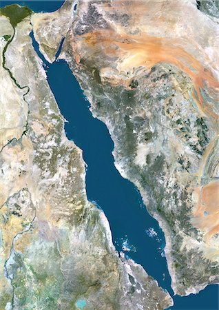
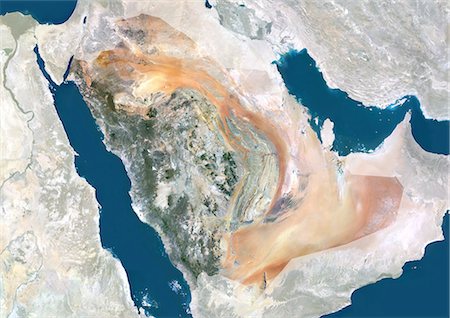
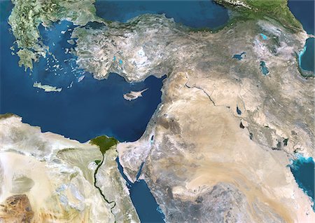
Satellite view of the Arabian Peninsula. This image was compiled from data acquired in 2014 by Landsat 8 satellite.
Con derechos protegidos
-
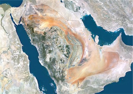
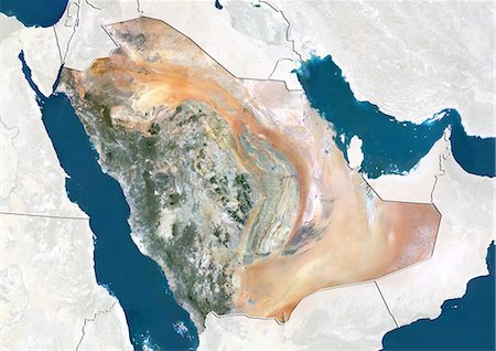
Relief map of Saudi Arabia (with border and mask). This image was compiled from data acquired by landsat 5 & 7 satellites combined with elevation data.
Con derechos protegidos
-

-
-

-
-

Lebanon, True Colour Satellite Image With Mask And Border. Lebanon, true colour satellite image with mask and border. This image was compiled from data acquired by LANDSAT 5 & 7 satellites.
Con derechos protegidos
-

Lebanon, True Colour Satellite Image With Border. Lebanon, true colour satellite image with border. This image was compiled from data acquired by LANDSAT 5 & 7 satellites.
Con derechos protegidos
-
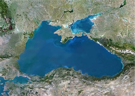
Black Sea, Europe, True Colour Satellite Image. True colour satellite image of the Black Sea, an inland sea bounded by Europe, Anatolia and the Caucasus. It lies between Bulgaria, Georgia, Romania, Russia, Turkey and Ukraine. The Black Sea connects to the Sea of Azov (at top). The Bosphorus strait connects it to the Sea of Marmara (down left). Composite image using LANDSAT 5 data.
Con derechos protegidos
-

Sea Of Marmara, Turkey, True Colour Satellite Image. True colour satellite image of the Sea of Marmara, the inland sea that connects the Black Sea (at top) to the Aegean Sea (down left). The Bosphorus Strait connects it to the Black Sea and the Dardanelles Strait to the Aegean Sea. Istanbul is located on the Bosphorus Strait. Composite image using LANDSAT 5 data.
Con derechos protegidos
-
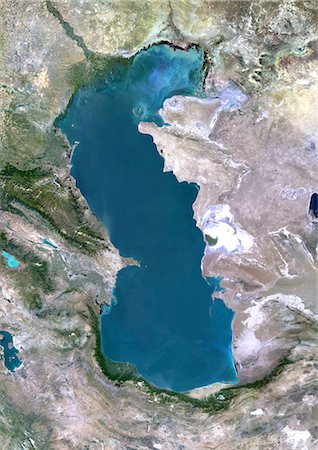
Caspian Sea, Asia, True Colour Satellite Image. True colour satellite image of the Caspian Sea in Asia. It is bounded by Iran, Russia, Kazakhstan, Turkmenistan and Azerbaijan. The Caspian Sea is the world's largest inland sea. Composite image using LANDSAT 5 data.
Con derechos protegidos
-

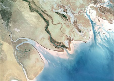
Syr Darya River Delta, Kazakhstan, True Colour Satellite Image. True colour satellite image of Syr Darya River Delta in Kazakhstan. The river irrigates the whole of Central Asia before emptying in the Aral Sea (top right and bottom left on the image). Composite image using LANDSAT 7 data.
Con derechos protegidos
-

Kura River Delta, Azerbaijan, True Colour Satellite Image. True colour satellite image of the Kura River Delta in Azerbaijan. The Kura River flows into the Caspian Sea. Composite image using LANDSAT 7 data.
Con derechos protegidos
-
-
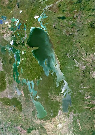
Lake Winnipeg, Canada, True Colour Satellite Image. True colour satellite image of Lake Winnipeg, in the province of Manitoba, Canada. The city of Winnipeg is at the bottom of the image. Composite image using LANDSAT 5 data.
Con derechos protegidos
-

Cairo City, Egypt, In 2000, True Colour Satellite Image. True colour satellite image of Cairo City, the capital city of Egypt. Image taken on 11 November 2000 using LANDSAT data.
Con derechos protegidos
-
Cairo City, Egypt, In 1972, True Colour Satellite Image. True colour satellite image of Cairo City, the capital city of Egypt. Image taken on 31 August 1972 using LANDSAT data.
Con derechos protegidos
-

-
-

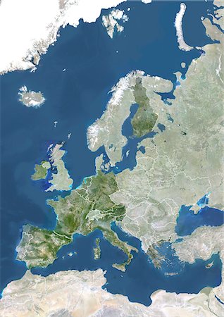
Member States Of The European Union In 2007, True Colour Satellite Image With Mask And Borders. True colour satellite image of the European Union in 2007, showing the 27 member states. This image in Lambert Conformal Conic projection was compiled from data acquired by LANDSAT 5 & 7 satellites.
Con derechos protegidos
-

Member States Of The European Union In 2004, True Colour Satellite Image With Mask And Borders. True colour satellite image of the European Union in 2004, showing the 25 member states. This image in Lambert Conformal Conic projection was compiled from data acquired by LANDSAT 5 & 7 satellites.
Con derechos protegidos
-

Turkey, Asia, True Colour Satellite Image With Mask. Satellite view of Turkey (with mask). This image was compiled from data acquired by LANDSAT 5 & 7 satellites.
Con derechos protegidos
-

Syria, Middle East, Asia, True Colour Satellite Image With Mask. Satellite view of Syria (with mask). This image was compiled from data acquired by LANDSAT 5 & 7 satellites.
Con derechos protegidos
-

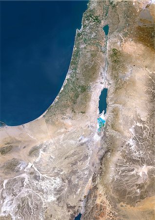
Israel, Middle East, Asia, True Colour Satellite Image With Mask. Satellite view of Israel (with mask). This image was compiled from data acquired by LANDSAT 5 & 7 satellites.
Con derechos protegidos
-

Georgia, Asia, True Colour Satellite Image With Mask. Satellite view of Georgia (with mask). This image was compiled from data acquired by LANDSAT 5 & 7 satellites.
Con derechos protegidos
-
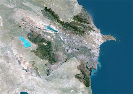
Azerbaijan, Asia, True Colour Satellite Image With Mask. Satellite view of Azerbaijan (with mask). This image was compiled from data acquired by LANDSAT 5 & 7 satellites.
Con derechos protegidos
-
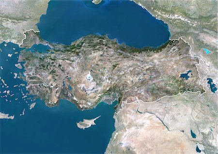
Turkey, Asia, True Colour Satellite Image With Border And Mask. Satellite view of Turkey (with border and mask). This image was compiled from data acquired by LANDSAT 5 & 7 satellites.
Con derechos protegidos
-
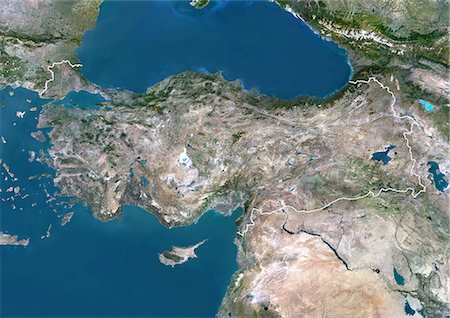
Turkey, Asia, True Colour Satellite Image With Border. Satellite view of Turkey (with border). This image was compiled from data acquired by LANDSAT 5 & 7 satellites.
Con derechos protegidos
-
Syria, Middle East, Asia, True Colour Satellite Image With Border And Mask. Satellite view of Syria (with border and mask). This image was compiled from data acquired by LANDSAT 5 & 7 satellites.
Con derechos protegidos
-

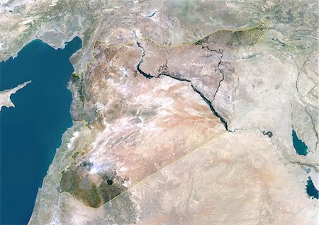
Syria, Middle East, Asia, True Colour Satellite Image With Border. Satellite view of Syria (with border). This image was compiled from data acquired by LANDSAT 5 & 7 satellites.
Con derechos protegidos
-

Israel, Middle East, Asia, True Colour Satellite Image With Border And Mask. Satellite view of Israel (with border and mask). This image was compiled from data acquired by LANDSAT 5 & 7 satellites.
Con derechos protegidos


