-
-
-
-

-
-

-

-
-

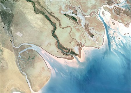
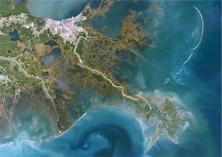
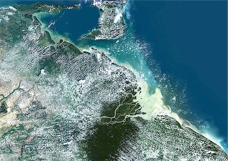
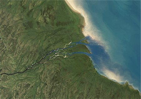
Satellite View of Saloum Delta And Gambia River, Western Africa
Con derechos protegidos
-
-
-
-
-

-

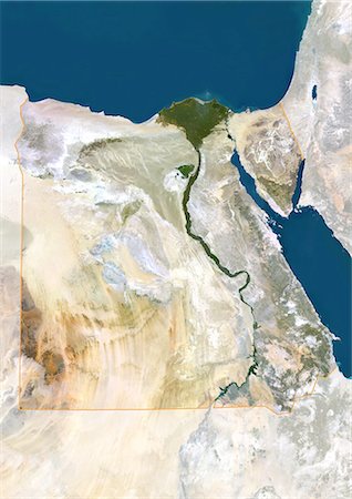
Egypt, True Colour Satellite Image With Border. Egypt, true colour satellite image with border. North is at top. In the center of the image is the Nile Delta, its lush vegetation following the path of the river. To the east of the Nile is the Gulf of Suez, which runs down the western side of the Sinai Peninsula. This image was compiled from data acquired by LANDSAT 5 & 7 satellites.
Con derechos protegidos
-
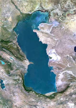
Caspian Sea, Asia, True Colour Satellite Image. True colour satellite image of the Caspian Sea in Asia. It is bounded by Iran, Russia, Kazakhstan, Turkmenistan and Azerbaijan. The Caspian Sea is the world's largest inland sea. Composite image using LANDSAT 5 data.
Con derechos protegidos
-
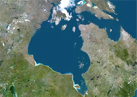
Hudson Bay, Canada, True Colour Satellite Image. True colour satellite image of Hudson Bay, a large body of water in northeastern Canada. A smaller offshoot of the bay, James Bay, lies to the south. North of Hudson Bay is Southampton island and westnorth is Baffin island. One group of islands in the southeast of the bay is the Belcher Islands. Composite image using LANDSAT 5 data.
Con derechos protegidos
-

Pechora River Delta, Russia, True Colour Satellite Image. True colour satellite image of the Pechora River Delta in Russia. The Pechora River flows into the Pechora Sea at Nosovaya. The sea at top is the Barents Sea. At the top of the image is part of Novaya Zemlya, an archipelago in the Arctic Ocean. Composite image using LANDSAT 5 data.
Con derechos protegidos
-
Don River Delta, Russia, True Colour Satellite Image. True colour satellite image of the Don River Delta in Russia. The Don River flows into the Sea of Azov. Composite image using LANDSAT 7 data.
Con derechos protegidos
-
Dnieper River Delta, Ukraine, True Colour Satellite Image. True colour satellite image of Dnieper River Delta in Ukraine. The Dnieper River flows into the Black Sea. Composite image using LANDSAT 7 data.
Con derechos protegidos
-

Syr Darya River Delta, Kazakhstan, True Colour Satellite Image. True colour satellite image of Syr Darya River Delta in Kazakhstan. The river irrigates the whole of Central Asia before emptying in the Aral Sea (top right and bottom left on the image). Composite image using LANDSAT 7 data.
Con derechos protegidos
-

Ural Delta, Kazakhstan, True Colour Satellite Image. True colour satellite image of the Ural Delta in Kazakhstan. The Ural River ends at the Caspian Sea. Composite image using LANDSAT 5 data.
Con derechos protegidos
-

Ob Estuary, Russia, True Colour Satellite Image. True colour satellite image of the Ob estuary in Siberia, Russia. The Ob River has the longest estuary in the world. Composite image using LANDSAT 5 data.
Con derechos protegidos
-
Mekong Delta, Vietnam, True Colour Satellite Image. True colour satellite image of the Mekong Delta in Vietnam. The Mekong delta region encompasses a large portion of southeastern Vietnam. The Mekong River empties into the South China Sea. Composite image using LANDSAT 7 data.
Con derechos protegidos
-

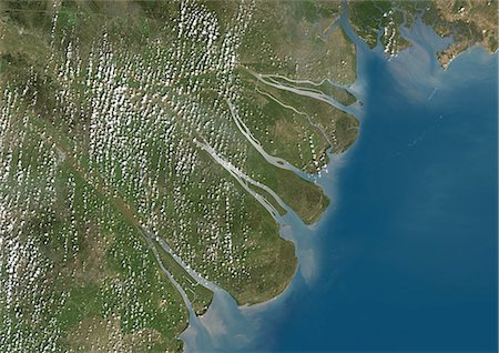
Mahanadi River Delta, India, True Colour Satellite Image. True colour satellite image of the Mahanadi River Delta in India. The Mahanadi River flows into the Gulf of Bengal. Composite image using LANDSAT 7 data.
Con derechos protegidos
-
Krishna River Delta, India, True Colour Satellite Image. True colour satellite image of Krishna River Delta in India. The Krishna River flows into the Bay of Bengal. Composite image using LANDSAT 7 data.
Con derechos protegidos
-

Kura River Delta, Azerbaijan, True Colour Satellite Image. True colour satellite image of the Kura River Delta in Azerbaijan. The Kura River flows into the Caspian Sea. Composite image using LANDSAT 7 data.
Con derechos protegidos
-

Kaveri River Delta, India, True Colour Satellite Image. True colour satellite image of the Kaveri River Delta in India. The Kaveri River empties into the Gulf of Bengal. Composite image using LANDSAT 7 data.
Con derechos protegidos
-

Irrawaddy Delta, Myanmar, True Colour Satellite Image. True colour satellite image of Irrawaddy Delta in Myanmar. The Irrawaddy River flows into the Bay of Bengal and Andaman Sea. On 2 May 2008, the delta suffered a major disaster, devastated by Cyclone Nargis. Composite image using LANDSAT 7 data.
Con derechos protegidos
-
Indus Delta, Pakistan, True Colour Satellite Image. True colour satellite image of the Indus Delta in Pakistan. The Indus River flows into the Arabian Sea near Pakistan's port city of Karachi (top left on the image). The city of Hyderabad, located on the east bank of the Indus River, is on the top centre of the image. India is southeast of the Indus delta. Composite image using LANDSAT 7 data.
Con derechos protegidos
-

Indigirka River Delta, Russia, True Colour Satellite Image. True colour satellite image of the Indigirka River Delta in Russia. The river flows into the Kolyma Bay, East Siberian Sea. Composite image using LANDSAT 5 data.
Con derechos protegidos
-

Yellow River Delta, China, True Colour Satellite Image. True colour satellite image of the Yellow River Delta in China. The Yellow River (or Huang He) empties into the Bohai Sea, the innermost gulf of the Yellow Sea. Composite image using LANDSAT 7 data.
Con derechos protegidos
-

Godavari River Delta, India, True Colour Satellite Image. True colour satellite image of the Godavari River Delta in India. The Godavari River flows into the Bay of Bengal near the city of Rajahmundry (top left of the image). Composite image using LANDSAT 7 data.
Con derechos protegidos
-

Red River Delta, Vietnam, True Colour Satellite Image. True colour satellite image of the Red River Delta in Vietnam. The Red River flows through northern Vietnam to the Gulf of Tonkin. Composite image using LANDSAT 7 data.
Con derechos protegidos
-

Chao Phraya Delta, Thailand, True Colour Satellite Image. True colour satellite image of Chao Phraya Delta in Thailand. The Chao Phraya is a major river in Thailand which runs through Bangkok (center of the image), the capital of Thailand, to the Gulf of Thailand. Composite image using LANDSAT 7 data.
Con derechos protegidos
-
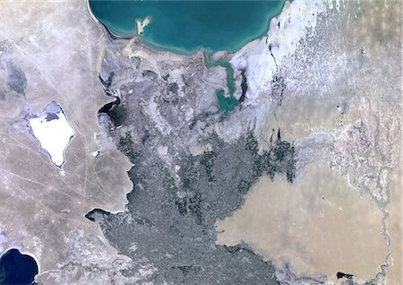
Amu Darya Delta, Uzbekistan, True Colour Satellite Image. True colour satellite image of Amu Darya Delta in Uzbekistan. The Amu Darya River flows into the Aral Sea. Composite image using LANDSAT 5 data.
Con derechos protegidos
-
Yukon River Delta, Alaska, Usa, True Colour Satellite Image. True colour satellite image of Yukon River Delta in Alaska, United States. The Yukon river empties into the Bering Sea at the Yukon-Kuskokwim Delta. Composite image using LANDSAT 7 data.
Con derechos protegidos
-

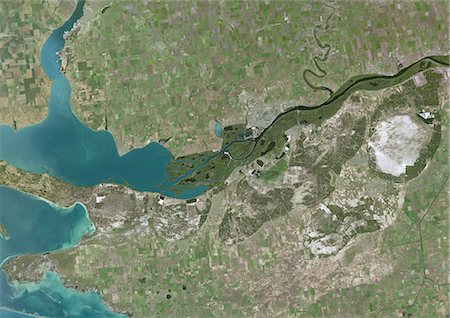
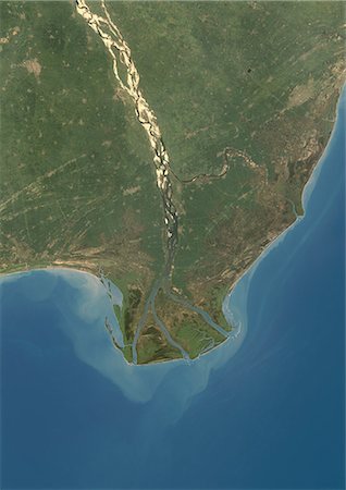
Porto Alegre, Brazil, True Colour Satellite Image. True colour satellite image of Porto Alegre in Brazil. Porto Alegre is the capital city of the southernmost Brazilian state of Rio Grande do Sul.The city is located on a delta, north of Lagoa dos Patos, a major lagoon. Composite image using LANDSAT 7 data.
Con derechos protegidos
-
Orinoco Delta, Venezuela, True Colour Satellite Image. True colour satellite image of the Orinoco Delta in eastern Venezuela, The Orinoco river flows into the Atlantic ocean. At top is the island of Trinidad in the Caribbean sea. Composite image using LANDSAT 5 data.
Con derechos protegidos
-

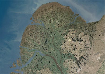
Mackenzie River Delta, Canada, True Colour Satellite Image. True colour satellite image of the Mackenzie River Delta. The Mackenzie River originates in Great Slave Lake, in the Northwest Territories (Canada), and flows north into the Arctic Ocean. Composite image using LANDSAT 7 data.
Con derechos protegidos
-
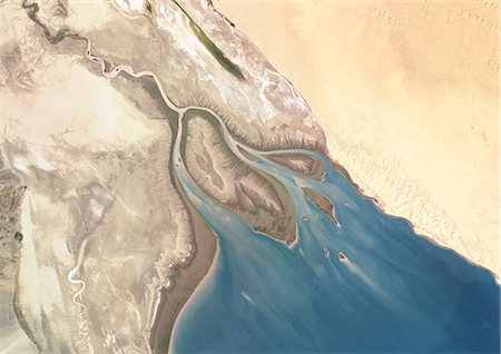
Colorado River Delta, Mexico, True Colour Satellite Image. True colour satellite image of the Colorado River Delta, Mexico. The Colorado River flows into the Gulf of California. Isla Montague is the large island in the center of the image. Composite image using LANDSAT 7 data.
Con derechos protegidos
-

Rio Coco Delta, Central America, True Colour Satellite Image. True colour satellite image of the Río Coco delta. The Río Coco is a river in southern Honduras and northern Nicaragua which flows into the Caribbean Sea. Part of the river forms the the Honduras-Nicaragua border. Composite image using LANDSAT 7 data.
Con derechos protegidos
-
Albany River Delta, Canada, True Colour Satellite Image. True colour satellite image of Albany River Delta in Canada. Composite image using LANDSAT 7 data.
Con derechos protegidos
-

Okavango Delta, Botswana, True Colour Satellite Image. True colour satellite image of the Okavango Delta located in Botswana. It is the world's largest inland delta. Composite image using LANDSAT 5 data.
Con derechos protegidos
-

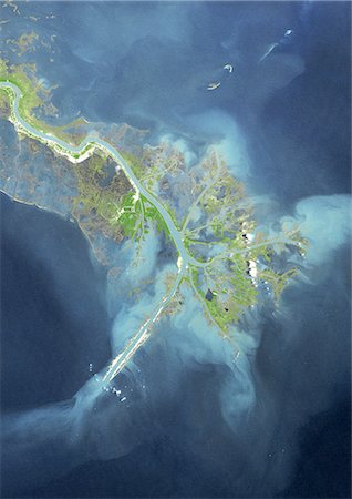
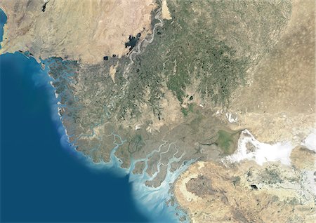
Ogooue River Delta, Gabon, True Colour Satellite Image. True colour satellite image of the Ogooué river delta, the principal river of Gabon in west central Africa. Composite image using LANDSAT 5 data.
Con derechos protegidos
-
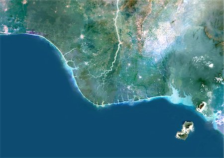
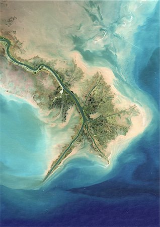
Niger River Delta, Nigeria, True Colour Satellite Image. True colour satellite image of the Niger River Delta in Nigeria, Africa. The city of Lagos, the second most populous city in Africa, is to be seen west of the Niger River Delta on the Atlantic coast in the Gulf of Guinea.Composite image using LANDSAT 5 data.
Con derechos protegidos
-

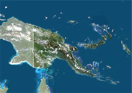
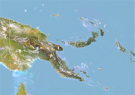
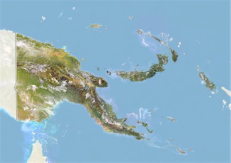
Papua New Guinea, Asia, True Colour Satellite Image With Mask. Satellite view of Papua New Guinea (with mask). This image was compiled from data acquired by LANDSAT 5 & 7 satellites.
Con derechos protegidos
-

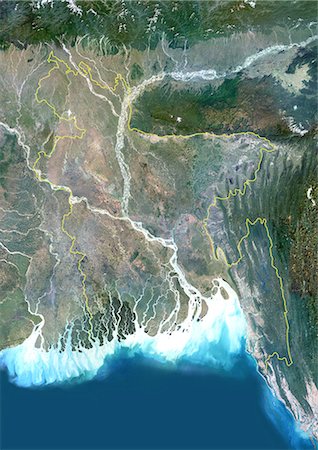
Bangladesh, Asia, True Colour Satellite Image With Mask. Satellite view of Bangladesh (with mask). This image was compiled from data acquired by LANDSAT 5 & 7 satellites.
Con derechos protegidos
-
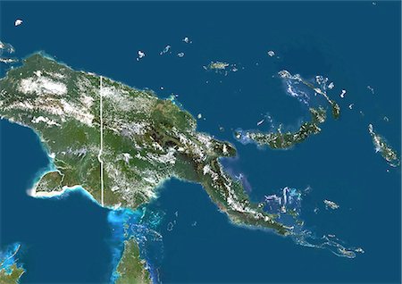
Papua New Guinea, Asia, True Colour Satellite Image With Border And Mask. Satellite view of Papua New Guinea (with border and mask). This image was compiled from data acquired by LANDSAT 5 & 7 satellites.
Con derechos protegidos
-
Papua New Guinea, Asia, True Colour Satellite Image With Border. Satellite view of Papua New Guinea (with border). This image was compiled from data acquired by LANDSAT 5 & 7 satellites.
Con derechos protegidos
-
Bangladesh, Asia, True Colour Satellite Image With Border And Mask. Satellite view of Bangladesh (with border and mask). This image was compiled from data acquired by LANDSAT 5 & 7 satellites.
Con derechos protegidos
-
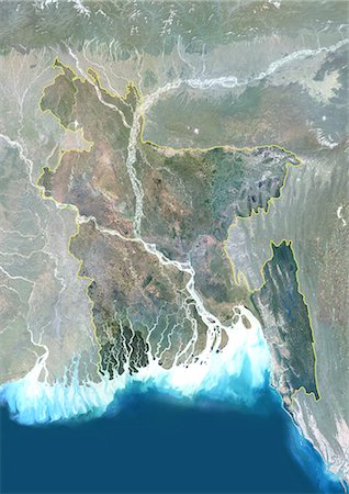
Bangladesh, Asia, True Colour Satellite Image With Border. Satellite view of Bangladesh (with border). This image was compiled from data acquired by LANDSAT 5 & 7 satellites.
Con derechos protegidos
-
-

Nile Delta, Egypt, True Colour Satellite Image. True colour satellite image of the Nile Delta. It is formed in Northern Egypt where the Nile River spreads out and drains into the Mediterranean Sea. This swamp region has always been rich in fauna and flora, contrasting with the surrounding desert. Image taken on 23 August 2000 using LANDSAT data.
Con derechos protegidos
-

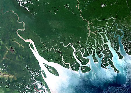
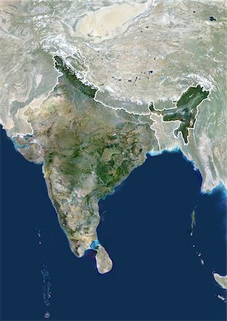
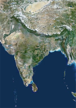
Ganges Delta, India And Bangladesh, True Colour Satellite Image. True colour satellite image of the Ganges River that forms an extensive delta where it empties into the Bay of Bengal. The delta is largely covered with a swamp forest known as the Sunderbans, which is home to the Royal Bengal Tiger. Image taken on 3 January 1989 using LANDSAT data.
Con derechos protegidos
-

Egypt, True Colour Satellite Image With Mask. Egypt, true colour satellite image with mask. North is at top. In the center of the image is the Nile Delta, its lush vegetation following the path of the river. To the east of the Nile is the Gulf of Suez, which runs down the western side of the Sinai Peninsula. This image was compiled from data acquired by LANDSAT 5 & 7 satellites.
Con derechos protegidos
-

-
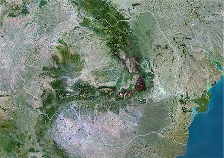
Romania, Europe, True Colour Satellite Image With Mask. Satellite view of Romania (with mask). This image was compiled from data acquired by LANDSAT 5 & 7 satellites.
Con derechos protegidos
-
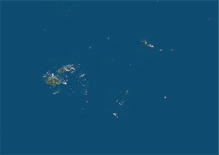
Fiji, Samoa, Tonga, Wallis And Futuna, Oceania, True Colour Satellite Image. Satellite view of Fiji, Samoa, Tonga, Wallis and Futuna Islands. This image was compiled from data acquired by LANDSAT 5 & 7 satellites.
Con derechos protegidos
-
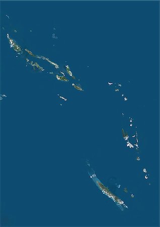
Vanuatu And Solomon Islands, Melanesia, Oceania, True Colour Satellite Image. Satellite view of Vanuatu and Solomon islands located in the South Pacific Ocean. This image was compiled from data acquired by LANDSAT 5 & 7 satellites.
Con derechos protegidos
-
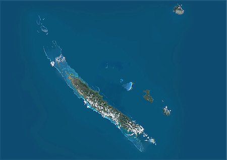
New Caledonia, French Overseas, Oceania, True Colour Satellite Image. Satellite view of New Caledonia, France. This image was compiled from data acquired by LANDSAT 5 & 7 satellites.
Con derechos protegidos
-

Romania, Europe, True Colour Satellite Image With Border And Mask. Satellite view of Romania (with border and mask). This image was compiled from data acquired by LANDSAT 5 & 7 satellites.
Con derechos protegidos
-
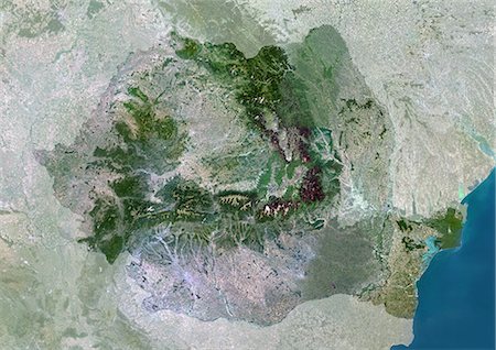
Romania, Europe, True Colour Satellite Image With Border. Satellite view of Romania (with border). This image was compiled from data acquired by LANDSAT 5 & 7 satellites.
Con derechos protegidos
-

-

-

Khatanga Delta, Siberia, Russia, True Colour Satellite Image. True colour satellite image of Khatanga Delta and Laptev Sea in Siberia. Image taken on 5 August 2000 using LANDSAT data.
Con derechos protegidos
-

-
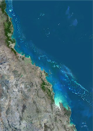
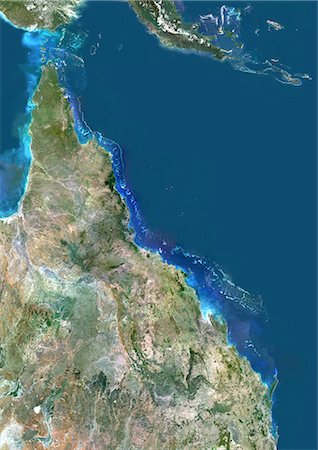
Satellite view of the Central Great Barrier Reef along Queensland's coastline in north-east Australia. The area covered goes from Cairns at north down to Townsville, Mackay and Rockhampton at south. This image was compiled from data acquired in 2014 by Landsat 8 satellite.
Con derechos protegidos
-
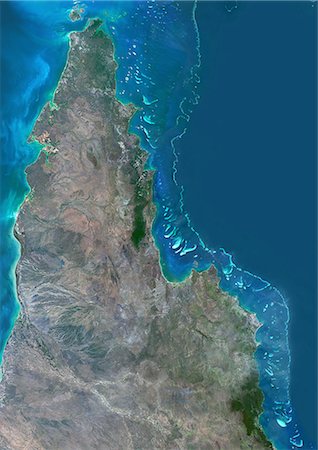
Satellite view of the Northern Great Barrier Reef along the east coast of Cape York Peninsula in north Australia. This image was compiled from data acquired in 2014 by Landsat 8 satellite.
Con derechos protegidos
-
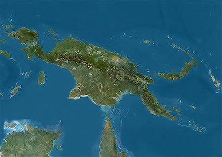
Satellite view of New Guinea. This image was compiled from data acquired by Landsat satellites.
Con derechos protegidos
-
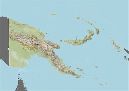
Relief map of Papua New Guinea (with border and mask). This image was compiled from data acquired by landsat 5 & 7 satellites combined with elevation data.
Con derechos protegidos
-
Papua New Guinea, Satellite Image With Bump Effect, With Border
Con derechos protegidos
-
Papua New Guinea, Satellite Image With Bump Effect, With Border and Mask
Con derechos protegidos
-

-

-

Nauru, True Colour Satellite Image. Nauru. True colour satellite image of Nauru, an island nation in Micronesia in the South Pacific. This image was taken on 29 June 1999, by the LANDSAT 7 satellite.
Con derechos protegidos
-

-
-
-

-

-
-

-
-

Solomon Islands, True Colour Satellite Image. Solomon Islands, true colour satellite image. This image was compiled from data acquired by LANDSAT 7 satellite.
Con derechos protegidos
-

-
-
-

-


