-
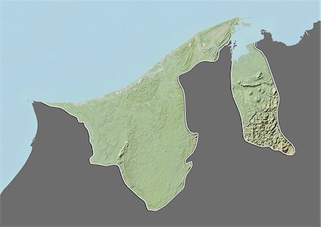
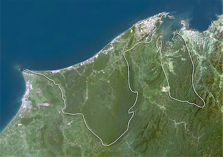
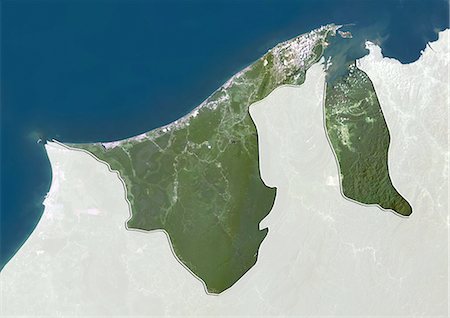
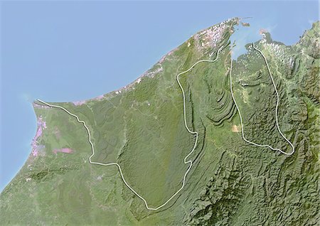
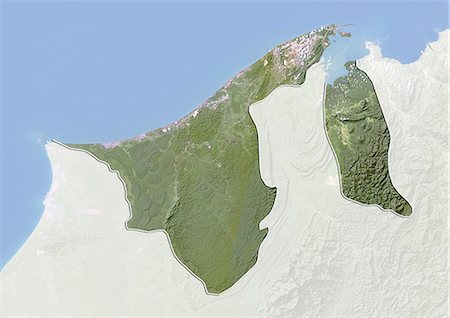
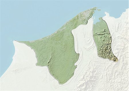
Relief map of Brunei (with border and mask). This image was compiled from data acquired by landsat 5 & 7 satellites combined with elevation data.
Rights-Managed
-
-
-
-
-
-
-

-
-

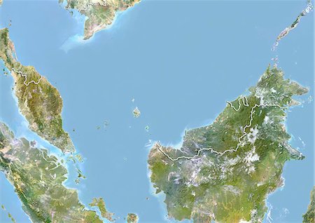
Satellite view of Southeast Asia. This image was compiled from data acquired by Landsat 7 & 8 satellites.
Rights-Managed
-
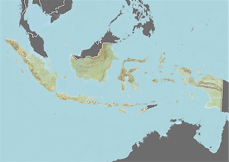
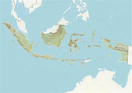
Relief map of Indonesia (with border and mask). This image was compiled from data acquired by landsat 5 & 7 satellites combined with elevation data.
Rights-Managed
-

-

-

-
-

Satellite view of West Nusa Tenggara Province, Indonesia (with country boundaries and mask). The image shows the two largest islands in the province which are Lombok in the west and the larger Sumbawa island in the east. This image was compiled from data acquired by Landsat satellites.
Rights-Managed
-

Satellite view of Taiwan. This image was compiled from data acquired by Landsat satellites.
Rights-Managed
-
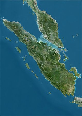
Satellite view of Sumatra, Malaysia and Singapore. This image was compiled from data acquired by Landsat satellites.
Rights-Managed
-
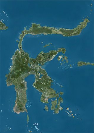
Satellite view of Sulawesi, Indonesia. This image was compiled from data acquired by Landsat satellites.
Rights-Managed
-
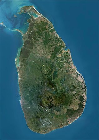
Satellite view of Sri Lanka. This image was compiled from data acquired by Landsat 8 satellite in 2014.
Rights-Managed
-
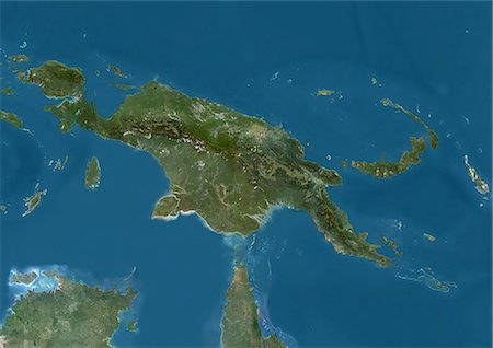
Satellite view of New Guinea. This image was compiled from data acquired by Landsat satellites.
Rights-Managed
-

Satellite view of the Maluku Islands, Indonesia. This image was compiled from data acquired by Landsat satellites.
Rights-Managed
-

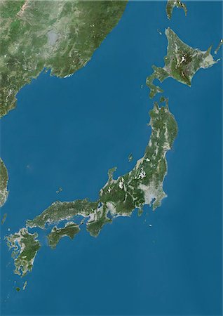
Satellite view of Japan and Korean Peninsula. This image was compiled from data acquired by Landsat satellites.
Rights-Managed
-

Satellite view of Japan and Korean Peninsula. This image was compiled from data acquired by Landsat satellites.
Rights-Managed
-
Satellite view of Japan. This image was compiled from data acquired by Landsat satellites.
Rights-Managed
-

Satellite view of the Caucasus. This image was compiled from data acquired in 2014 by Landsat 8 satellite.
Rights-Managed
-
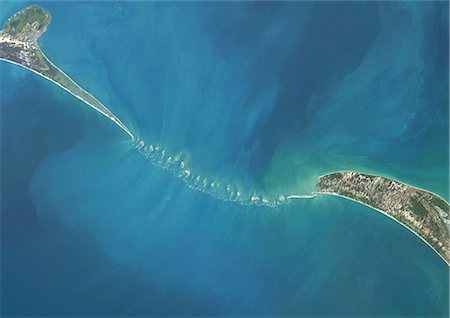
Satellite view of Adam's Bridge. This chain of limestone shoals connects Sri Lanka to India. This image was taken in 2014 by Landsat 8 satellite.
Rights-Managed
-

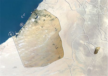
Satellite view of the Emirate of Sharjah, United Arab Emirates. This image was compiled from data acquired by LANDSAT 5 & 7 satellites.
Rights-Managed
-
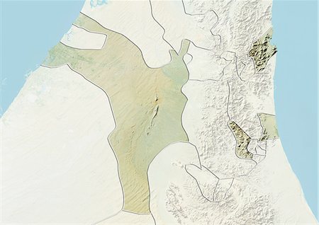
Relief map of the Emirate of Sharjah, United Arab Emirates. This image was compiled from data acquired by LANDSAT 5 & 7 satellites combined with elevation data.
Rights-Managed
-
Satellite view of the Emirate of Dubai, United Arab Emirates. This image was compiled from data acquired by LANDSAT 5 & 7 satellites.
Rights-Managed
-
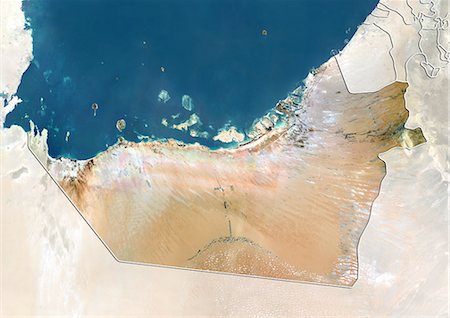
Satellite view of the Emirate of Abu Dhabi, United Arab Emirates. This image was compiled from data acquired by LANDSAT 5 & 7 satellites.
Rights-Managed
-

Relief map of the Emirate of Abu Dhabi, United Arab Emirates. This image was compiled from data acquired by LANDSAT 5 & 7 satellites combined with elevation data.
Rights-Managed
-
Satellite view of the region of Tohoku, Japan. This image was compiled from data acquired by LANDSAT 5 & 7 satellites.
Rights-Managed
-
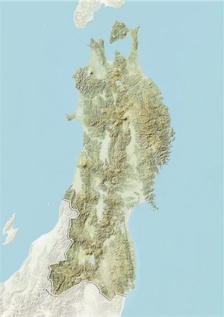
Relief map of the region of Tohoku, Japan. This image was compiled from data acquired by LANDSAT 5 & 7 satellites combined with elevation data.
Rights-Managed
-
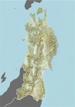
Relief map of the region of Tohoku, Japan. This image was compiled from data acquired by LANDSAT 5 & 7 satellites combined with elevation data.
Rights-Managed
-

Satellite view of the region of Shikoku, Japan. This image was compiled from data acquired by LANDSAT 5 & 7 satellites.
Rights-Managed
-

Relief map of the region of Shikoku, Japan. This image was compiled from data acquired by LANDSAT 5 & 7 satellites combined with elevation data.
Rights-Managed
-

Relief map of the region of Shikoku, Japan. This image was compiled from data acquired by LANDSAT 5 & 7 satellites combined with elevation data.
Rights-Managed
-

Satellite view of the region of Kyushu, Japan. This image was compiled from data acquired by LANDSAT 5 & 7 satellites.
Rights-Managed
-

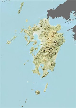
Relief map of the region of Kyushu, Japan. This image was compiled from data acquired by LANDSAT 5 & 7 satellites combined with elevation data.
Rights-Managed
-
Relief map of the region of Kyushu, Japan. This image was compiled from data acquired by LANDSAT 5 & 7 satellites combined with elevation data.
Rights-Managed
-
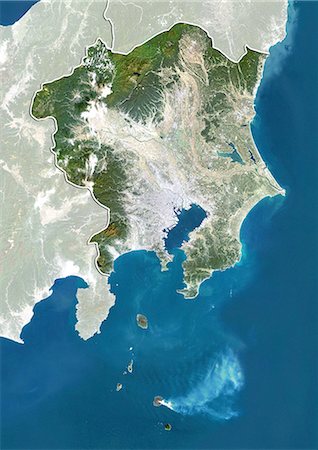
Satellite view of the region of Kanto, Japan. This image was compiled from data acquired by LANDSAT 5 & 7 satellites.
Rights-Managed
-
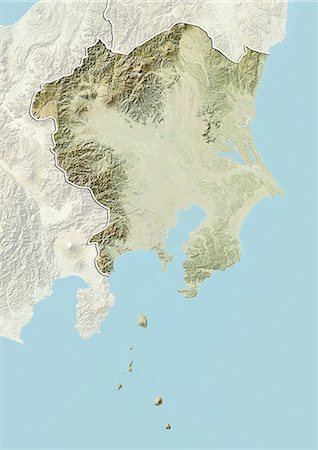
Relief map of the region of Kanto, Japan. This image was compiled from data acquired by LANDSAT 5 & 7 satellites combined with elevation data.
Rights-Managed
-
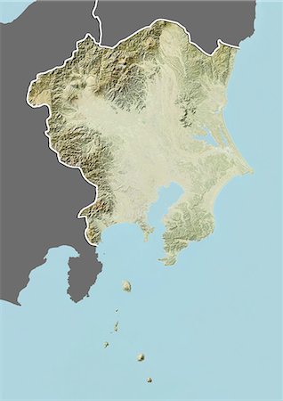
Relief map of the region of Kanto, Japan. This image was compiled from data acquired by LANDSAT 5 & 7 satellites combined with elevation data.
Rights-Managed
-
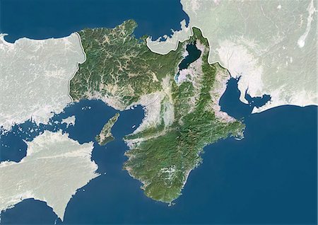
Satellite view of the region of Kansai, Japan. This image was compiled from data acquired by LANDSAT 5 & 7 satellites.
Rights-Managed
-
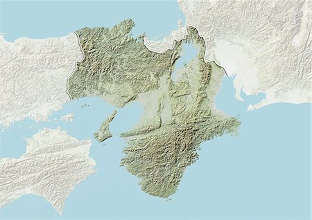
Relief map of the region of Kansai, Japan. This image was compiled from data acquired by LANDSAT 5 & 7 satellites combined with elevation data.
Rights-Managed
-

Relief map of the region of Kansai, Japan. This image was compiled from data acquired by LANDSAT 5 & 7 satellites combined with elevation data.
Rights-Managed
-

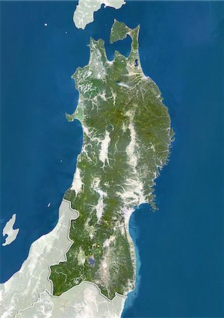
Satellite view of the region of Hokkaido, Japan. This image was compiled from data acquired by LANDSAT 5 & 7 satellites.
Rights-Managed
-

Relief map of the region of Hokkaido, Japan. This image was compiled from data acquired by LANDSAT 5 & 7 satellites combined with elevation data.
Rights-Managed
-
Satellite view of the region of Chugoku, Japan. This image was compiled from data acquired by LANDSAT 5 & 7 satellites.
Rights-Managed
-

Relief map of the region of Chugoku, Japan. This image was compiled from data acquired by LANDSAT 5 & 7 satellites combined with elevation data.
Rights-Managed
-

Relief map of the region of Chugoku, Japan. This image was compiled from data acquired by LANDSAT 5 & 7 satellites combined with elevation data.
Rights-Managed
-

Satellite view of the region of Chubu, Japan. This image was compiled from data acquired by LANDSAT 5 & 7 satellites.
Rights-Managed
-

Relief map of the region of Chubu, Japan. This image was compiled from data acquired by LANDSAT 5 & 7 satellites combined with elevation data.
Rights-Managed
-
Relief map of the region of Chubu, Japan. This image was compiled from data acquired by LANDSAT 5 & 7 satellites combined with elevation data.
Rights-Managed
-

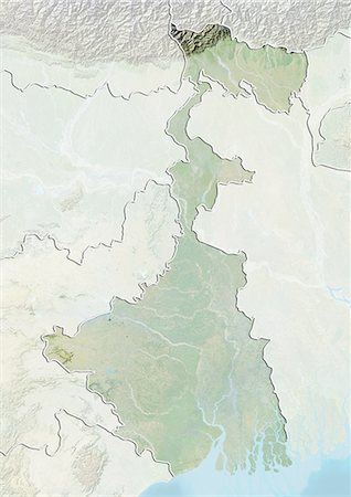
Satellite view of the State of West Bengal, India. This image was compiled from data acquired by LANDSAT 5 & 7 satellites.
Rights-Managed
-
Relief map of the State of West Bengal, India. This image was compiled from data acquired by LANDSAT 5 & 7 satellites combined with elevation data.
Rights-Managed
-
Satellite view of the State of Tamil Nadu, India. This image was compiled from data acquired by LANDSAT 5 & 7 satellites.
Rights-Managed
-

Relief map of the State of Tamil Nadu, India. This image was compiled from data acquired by LANDSAT 5 & 7 satellites combined with elevation data.
Rights-Managed
-

Satellite view of the State of Orissa, India. This image was compiled from data acquired by LANDSAT 5 & 7 satellites.
Rights-Managed
-
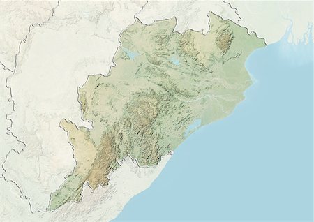
Relief map of the State of Orissa, India. This image was compiled from data acquired by LANDSAT 5 & 7 satellites combined with elevation data.
Rights-Managed
-
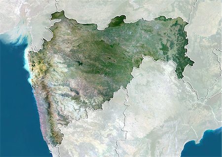
Satellite view of the State of Maharashtra, India. This image was compiled from data acquired by LANDSAT 5 & 7 satellites.
Rights-Managed
-
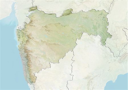
Relief map of the State of Maharashtra, India. This image was compiled from data acquired by LANDSAT 5 & 7 satellites combined with elevation data.
Rights-Managed
-
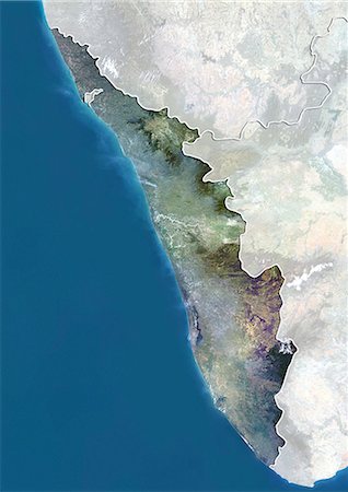
Satellite view of the State of Kerala, India. This image was compiled from data acquired by LANDSAT 5 & 7 satellites.
Rights-Managed
-
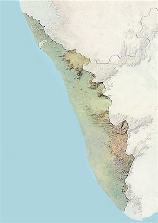
Relief map of the State of Kerala, India. This image was compiled from data acquired by LANDSAT 5 & 7 satellites combined with elevation data.
Rights-Managed
-
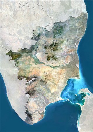
Satellite view of the State of Karnataka, India. This image was compiled from data acquired by LANDSAT 5 & 7 satellites.
Rights-Managed
-

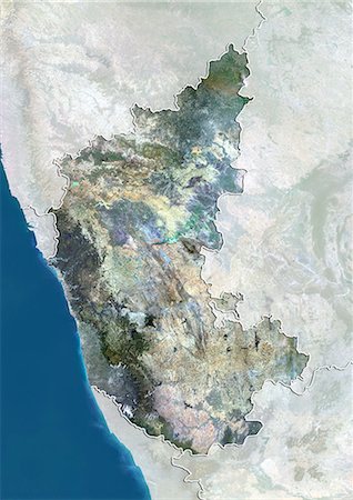
Relief map of the State of Karnataka, India. This image was compiled from data acquired by LANDSAT 5 & 7 satellites combined with elevation data.
Rights-Managed
-
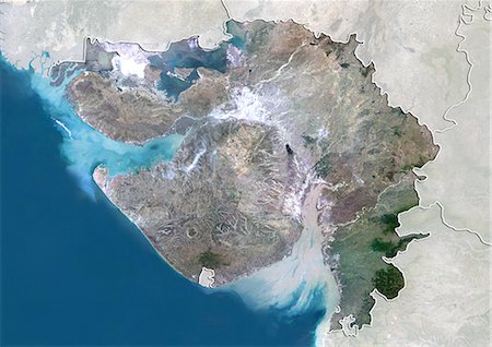
Satellite view of the State of Gujarat, India. This image was compiled from data acquired by LANDSAT 5 & 7 satellites.
Rights-Managed
-
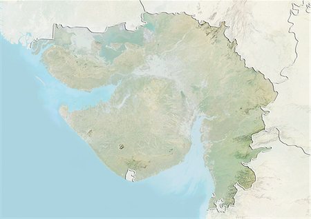
Relief map of the State of Gujarat, India. This image was compiled from data acquired by LANDSAT 5 & 7 satellites combined with elevation data.
Rights-Managed
-
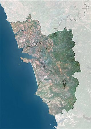
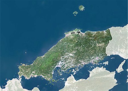
Satellite view of the State of Goa, India. This image was compiled from data acquired by LANDSAT 5 & 7 satellites.
Rights-Managed
-
Satellite view of the State of Andhra Pradesh, India. This image was compiled from data acquired by LANDSAT 5 & 7 satellites.
Rights-Managed
-
Relief map of the State of Andhra Pradesh, India. This image was compiled from data acquired by LANDSAT 5 & 7 satellites combined with elevation data.
Rights-Managed
-
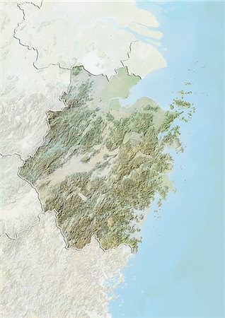
Satellite view of the province of Zhejiang, China. This image was compiled from data acquired by LANDSAT 5 & 7 satellites.
Rights-Managed
-
Relief map of the province of Zhejiang, China. This image was compiled from data acquired by LANDSAT 5 & 7 satellites combined with elevation data.
Rights-Managed
-
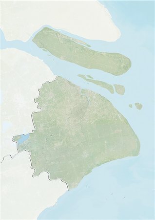
Satellite view of Tianjin, China. This image was compiled from data acquired by LANDSAT 7 satellite.
Rights-Managed
-
Relief map of Tianjin, China. This image was compiled from data acquired by LANDSAT 7 satellite combined with elevation data.
Rights-Managed
-
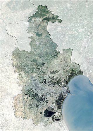
Satellite view of Shanghai, China. This image was compiled from data acquired by LANDSAT 7 satellite.
Rights-Managed
-
Relief map of Shanghai, China. This image was compiled from data acquired by LANDSAT 7 satellite combined with elevation data.
Rights-Managed
-
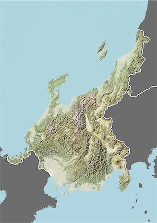
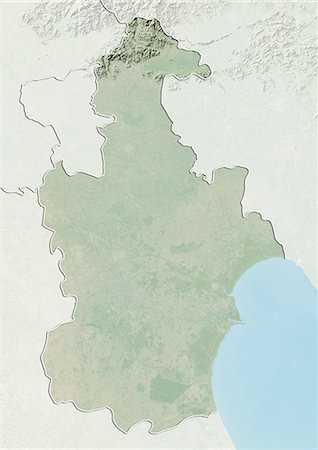
Satellite view of the province of Liaoning, China. This image was compiled from data acquired by LANDSAT 5 & 7 satellites.
Rights-Managed
-

Relief map of the province of Liaoning, China. This image was compiled from data acquired by LANDSAT 5 & 7 satellites combined with elevation data.
Rights-Managed
-

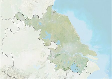
Satellite view of the province of Jiangsu, China. This image was compiled from data acquired by LANDSAT 5 & 7 satellites.
Rights-Managed
-
Relief map of the province of Jiangsu, China. This image was compiled from data acquired by LANDSAT 5 & 7 satellites combined with elevation data.
Rights-Managed
-
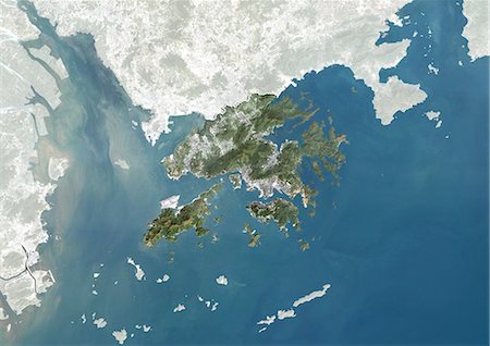
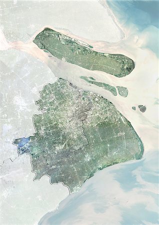
Satellite view of Hong Kong, China. This image was compiled from data acquired by LANDSAT 7 satellite.
Rights-Managed
-
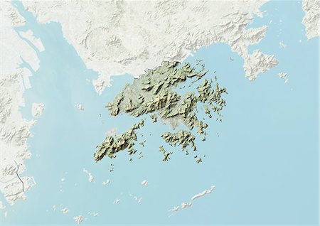
Relief map of Hong Kong, China. This image was compiled from data acquired by LANDSAT 7 satellite combined with elevation data.
Rights-Managed
-
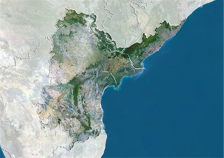
Satellite view of the province of Hebei, China. This image was compiled from data acquired by LANDSAT 5 & 7 satellites.
Rights-Managed
-
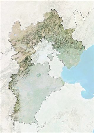
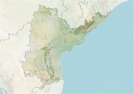
Relief map of the province of Hebei, China. This image was compiled from data acquired by LANDSAT 5 & 7 satellites combined with elevation data.
Rights-Managed
-
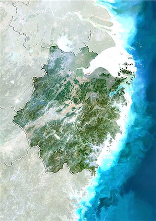
Satellite view of the province of Hainan, China. This image was compiled from data acquired by LANDSAT 5 & 7 satellites.
Rights-Managed
-
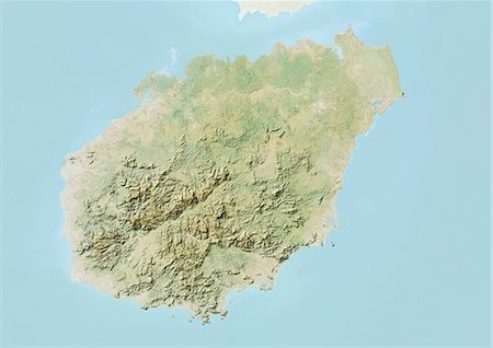
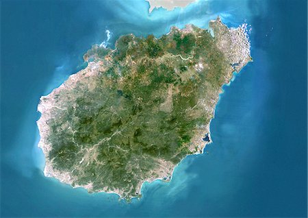
Relief map of the province of Hainan, China. This image was compiled from data acquired by LANDSAT 5 & 7 satellites combined with elevation data.
Rights-Managed
-
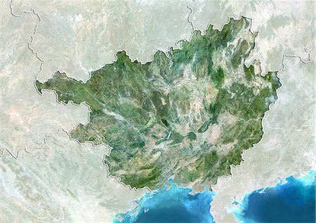
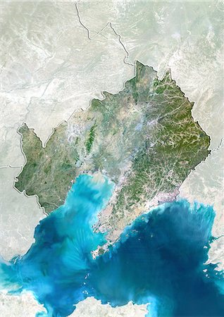
Satellite view of the region of Guangxi, China. This image was compiled from data acquired by LANDSAT 5 & 7 satellites.
Rights-Managed
-

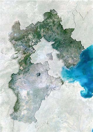
Relief map of the region of Guangxi, China. This image was compiled from data acquired by LANDSAT 5 & 7 satellites combined with elevation data.
Rights-Managed


