-

Reunion Political Map with prefecture Saint-Denis, important cities and rivers. English labeling and scaling. JPEG and Illustrator 8 EPS. Text converted to paths and no fonts are required. Vector version can be scaled to any size without loss of quality.
Budget Royalty-Free & Subscription
-
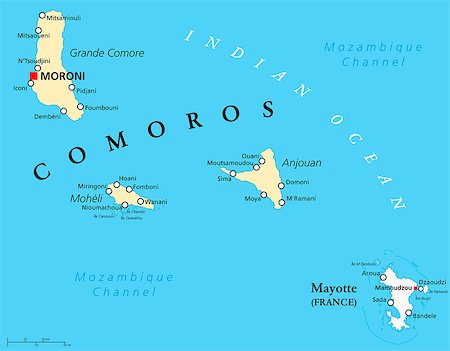
Political Map of Comoros with capital Moroni, important cities and the islands Grande Comore, Moheli and Anjouan. With the archipelago Mayotte, an oversea department of France. English labeling and scaling. JPEG and Illustrator 8 EPS. Text converted to paths and no fonts are required. Vector version can be scaled to any size without loss of quality.
Budget Royalty-Free & Subscription
-
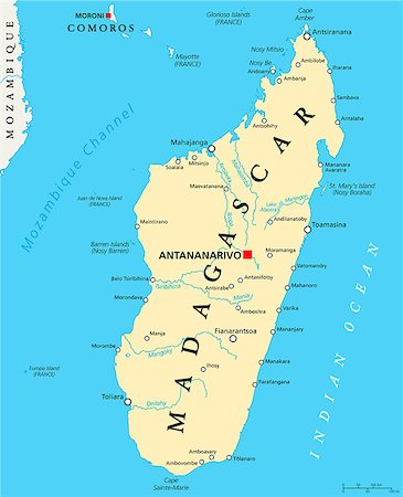
Madagascar Political Map with capital Antananarivo, national borders, important cities, rivers and lakes. English labeling and scaling. Illustration.
Budget Royalty-Free & Subscription
-

Mauritius Political Map with capital Port Louis, the islands Rodrigues and Agalega and with the archipelago Saint Brandon. English labeling and scaling. JPEG and Illustrator 8 EPS. Text converted to paths and no fonts are required. Vector version can be scaled to any size without loss of quality.
Budget Royalty-Free & Subscription
-

Seychelles Political Map with capital Victoria, important cities and islands and an overview map of the whole archipelago. English labeling and scaling. JPEG and Illustrator 8 EPS. Text converted to paths and no fonts are required. Vector version can be scaled to any size without loss of quality.
Budget Royalty-Free & Subscription
-
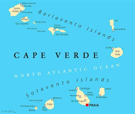
Cape Verde Political Map with capital Praia and important cities. English labeling and scaling. Illustration.
Budget Royalty-Free & Subscription
-
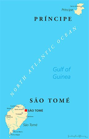
Sao Tome and Principe Political Map with capital Sao Tome. African island nation in the gulf of Guinea with two archipelagos. English labeling and scaling. JPEG and Illustrator 8 EPS. Text converted to paths and no fonts are required. Vector version can be scaled to any size without loss of quality.
Budget Royalty-Free & Subscription
-

Zanzibar, political map of the semi-autonomous part of Tanzania in East Africa, an archipelago in the Indian Ocean composed of the two islands Unguja and Pemba. English labeling and scaling. JPEG and Illustrator 8 EPS. Text converted to paths and no fonts are required. Vector version can be scaled to any size without loss of quality.
Budget Royalty-Free & Subscription
-
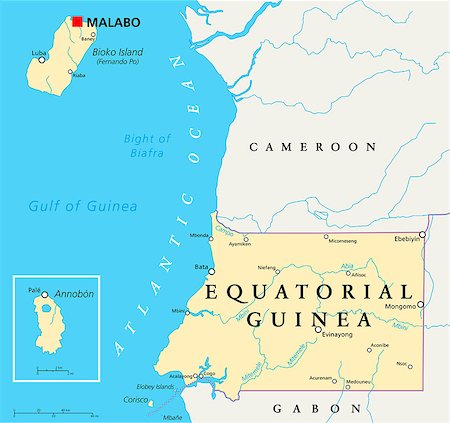
Equatorial Guinea Political Map with capital Malabo, national borders, important cities and rivers. English labeling and scaling. Illustration.
Budget Royalty-Free & Subscription
-
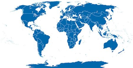
World political map outline. Detailed map of the world with shorelines and national borders under the Robinson projection. Blue illustration on white background.
Budget Royalty-Free & Subscription
-
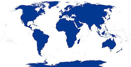
World map silhouette. The surface of the Earth. Detailed map of the world with shorelines under the Robinson projection. Blue illustration on white background.
Budget Royalty-Free & Subscription
-
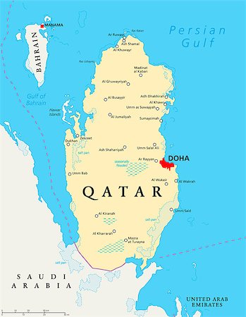
Qatar political map with capital Doha, national borders, important cities, salt pans and reefs. English labeling and scaling. Illustration.
Budget Royalty-Free & Subscription
-

Haiti Political Map with capital Port-au-Prince, with national borders, important cities, rivers and lakes. English labeling and scaling. Illustration.
Budget Royalty-Free & Subscription
-

Grand Cayman Island Political Map with capital George Town and important places, the largest of the three Cayman Islands, a British Overseas Territory in the western Caribbean Sea. English labeling and scaling. Illustration.
Budget Royalty-Free & Subscription
-

Cayman Islands Political Map with capital George Town and important places. A British Overseas Territory in the western Caribbean Sea. English labeling and scaling. Illustration.
Budget Royalty-Free & Subscription
-
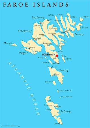
Faroe Islands political map with capital Torshavn and important cities. English labeling and scaling. Illustration.
Budget Royalty-Free & Subscription
-

Lesotho Political Map with capital Maseru, national borders, important cities and rivers. English labeling and scaling. Illustration.
Budget Royalty-Free & Subscription
-
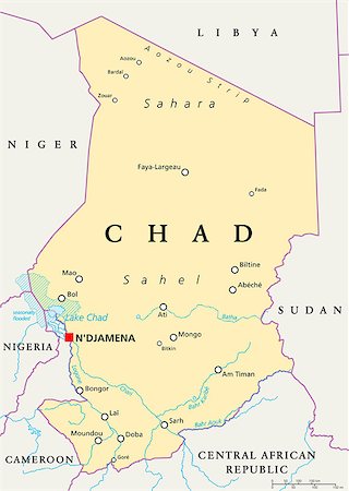
Chad Political Map with capital N'Djamena, national borders, important cities, rivers and lakes. English labeling and scaling. Illustration.
Budget Royalty-Free & Subscription
-
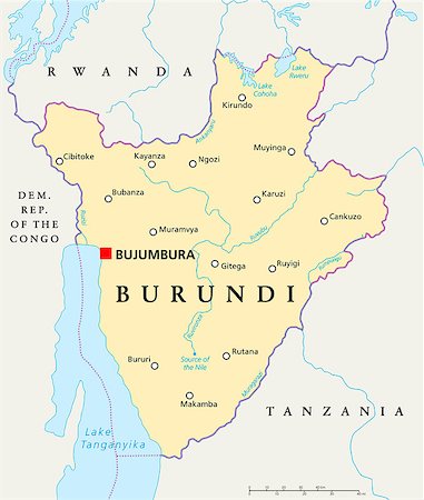
Burundi Political Map with capital Bujumbura, national borders, important cities, rivers and lakes. English labeling and scaling. Illustration.
Budget Royalty-Free & Subscription
-

Malawi Political Map with capital Lilongwe, national borders, important cities, rivers and lakes. English labeling and scaling. JPEG and Illustrator 8 EPS. Text converted to paths and no fonts are required. Vector version can be scaled to any size without loss of quality.
Budget Royalty-Free & Subscription
-

Swaziland Political Map with capital Mbabane, national borders, important cities, rivers and lakes. English labeling and scaling. JPEG and Illustrator 8 EPS. Text converted to paths and no fonts are required. Vector version can be scaled to any size without loss of quality.
Budget Royalty-Free & Subscription
-
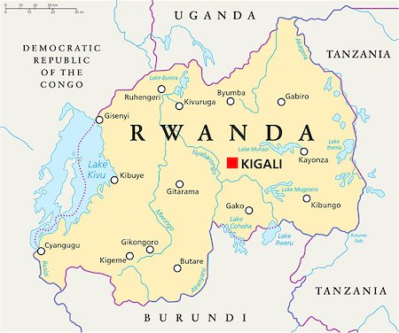
Rwanda Political Map with capital Kigali, national borders, important cities, rivers and lakes. English labeling and scaling. JPEG and Illustrator 8 EPS. Text converted to paths and no fonts are required. Vector version can be scaled to any size without loss of quality.
Budget Royalty-Free & Subscription
-
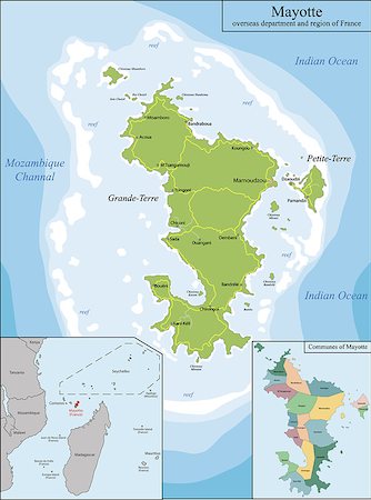
Mayotte is an overseas department and region of France officially named Department of Mayotte
Budget Royalty-Free & Subscription
-

American Samoa political map with capital Pago Pago is an United States territory and part of Samoan Islands in South Pacific Ocean. English labeling and scaling. Illustration.
Budget Royalty-Free & Subscription
-

Samoa political map with capital Apia and important places. Formerly known as Western Samoa, part of Samoan Islands, with main islands Savaii and Upolu. English labeling and scaling. Illustration.
Budget Royalty-Free & Subscription
-
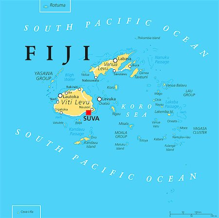
Fiji political map with capital Suva, islands, important cities and reefs. English labeling and scaling. Illustration.
Budget Royalty-Free & Subscription
-
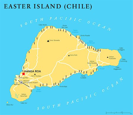
Easter Island political map with capital Hanga Roa, important places, lakes and monumental Moai statues. Chilean island in the South Pacific Ocean. English labeling and scaling. Illustration.
Budget Royalty-Free & Subscription
-

Western Sahara political map with capital Laayoune, national borders, important places and rivers. A disputed territory in the Maghreb region of North Africa. Illustration with English labeling.
Budget Royalty-Free & Subscription
-
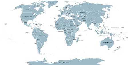
World political map. Detailed map of the world with shorelines, national borders and country names. Robinson projection, english labeling, grey illustration on white background.
Budget Royalty-Free & Subscription
-
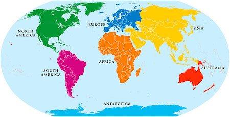
Seven continents world map. Asia, Africa, North and South America, Antarctica, Europe and Australia. Detailed map with shorelines and national borders under Robinson projection on white background.
Budget Royalty-Free & Subscription
-

North Korea and South Korea political map with capitals Pyongyang and Seoul. Korean peninsula, national borders, important cities, rivers and lakes. English labeling and scaling. Illustration.
Budget Royalty-Free & Subscription
-

Korean peninsula political map with North and South Korea and the capitals Pyongyang and Seoul, national borders, important cities, rivers and lakes. English labeling and scaling. Illustration.
Budget Royalty-Free & Subscription
-
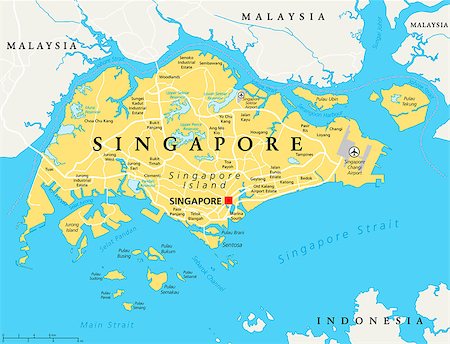
Singapore island political map with capital Singapore, national borders and important cities. English labeling and scaling. Illustration.
Budget Royalty-Free & Subscription
-

Falkland Islands, also Malvinas, political map with capital Stanley, administered under United Kingdom, claimed by Argentina. English labeling and scaling. Illustration.
Budget Royalty-Free & Subscription
-
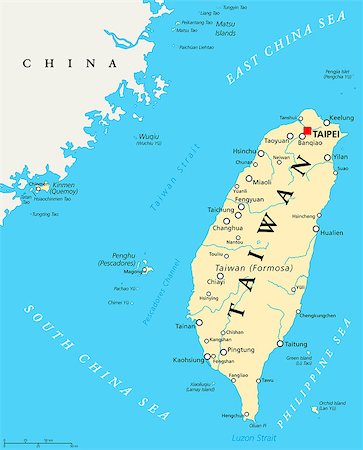
Taiwan, Republic of China, political map with capital Taipei, national borders, important cities, rivers and lakes. English labeling and scaling. Illustration.
Budget Royalty-Free & Subscription
-

Lebanon political map with capital Beirut, national borders, important cities, rivers and lakes. English labeling and scaling. Illustration.
Budget Royalty-Free & Subscription
-

Hong Kong and vicinity political map. World financial Centre and Special Administrative Region in Guangdong Province of China. English labeling and scaling. Illustration.
Budget Royalty-Free & Subscription
-
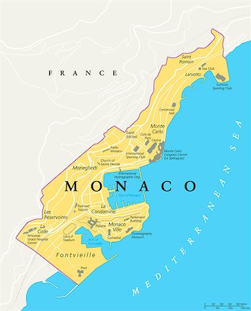
Monaco political map. City state in on the French Riviera, France, with national borders, important buildings and sights. English labeling and scaling. Illustration.
Budget Royalty-Free & Subscription
-

Malta political map with capital Valletta and important cities. English labeling and scaling. Illustration.
Budget Royalty-Free & Subscription
-
-
-
-
-
-
-
-

-
-
-

-

-

Map of South America. Blue silhouette illustration on white background with english scaling.
Budget Royalty-Free & Subscription
-

Political map of South America with all countries and national borders. Blue outline illustration on white background and english scaling.
Budget Royalty-Free & Subscription
-

Europe Political Map and surrounding region. Blue silhouette illustration on white background with english scaling.
Budget Royalty-Free & Subscription
-
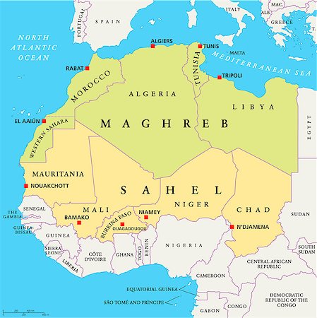
Maghreb and Sahel Political Map with capitals and national borders. English labeling and scaling. JPEG and Illustrator 10 EPS. Text converted to paths and no fonts are required. Vector version can be scaled to any size without loss of quality.
Budget Royalty-Free & Subscription
-
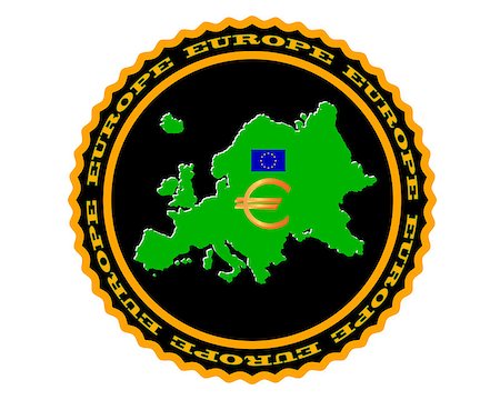
symbol of Europe and a map of Europe on white background
Budget Royalty-Free & Subscription
-

Kuwait political map with capital Kuwait City, national borders, important cities and rivers. English labeling and scaling. Illustration.
Budget Royalty-Free & Subscription
-

Arctic Ocean map with North Pole and Arctic Circle. Arctic region map with countries, national borders, rivers and lakes. Map without sea ice. English labeling and scaling.
Budget Royalty-Free & Subscription
-

Morocco political map with capital Rabat, national borders, important cities and rivers. Illustration with English labeling and scaling.
Budget Royalty-Free & Subscription
-
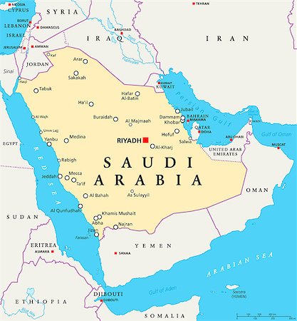
Saudi Arabia political map with capital Riyadh, national borders and important cities. English labeling and scaling. Illustration.
Budget Royalty-Free & Subscription
-

Romania political map with capital Bucharest, national borders, important cities, rivers and lakes. English labeling and scaling. Illustration.
Budget Royalty-Free & Subscription
-

Baltic countries political map. Baltic states area with capitals, national borders, important cities, rivers and lakes. English labeling and scaling.
Budget Royalty-Free & Subscription
-

Lithuania political map with capital Vilnius, national borders, important cities, rivers and lakes. English labeling and scaling. Illustration.
Budget Royalty-Free & Subscription
-

Latvia political map with capital Riga, national borders, important cities, rivers and lakes. English labeling and scaling. Illustration.
Budget Royalty-Free & Subscription
-
Small Flag of Territory of Christmas Island on a Map Background with Selective Focus.
Budget Royalty-Free & Subscription
-

Small Flag Republic of Madagascar on a Map Background with Selective Focus.
Budget Royalty-Free & Subscription
-

Australia is a sovereign country comprising the mainland of the Australian continent, the island of Tasmania and numerous smaller islands.
Budget Royalty-Free & Subscription
-

Australia is a sovereign country comprising the mainland of the Australian continent, the island of Tasmania and numerous smaller islands.
Budget Royalty-Free & Subscription
-
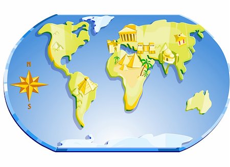
Illustration. Map of the world with famous landmarks and compass.
Budget Royalty-Free & Subscription
-
-

-
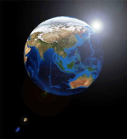
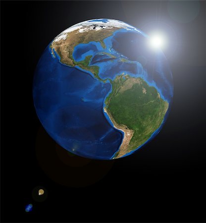
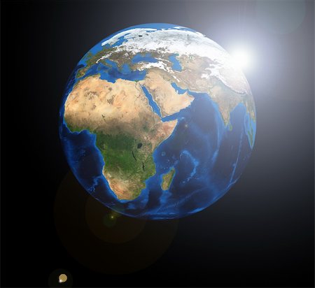
Europe and Asia on the Earth planet. Data source: Nasa
Budget Royalty-Free & Subscription
-
-
-
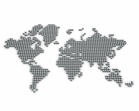
Continents made from silver balls, perspective version isolated on white background
Budget Royalty-Free & Subscription
-
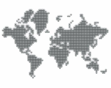
Continents made from silver balls isolated on white background
Budget Royalty-Free & Subscription
-
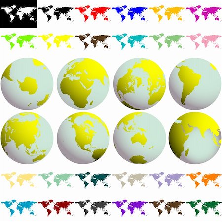
earth globes and maps against white background, abstract collection; vector art illustration
Budget Royalty-Free & Subscription
-

-
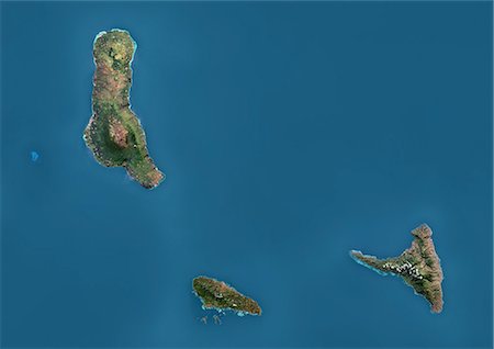
Satellite view of the Comoros Archipelago. This image was compiled from data acquired by Landsat satellites.
Rights-Managed
-
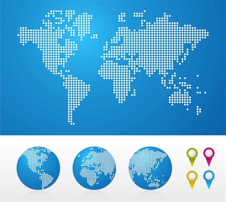
Dot World maps and globes business background. Vector file available.
Budget Royalty-Free & Subscription
-
-
-

-
-
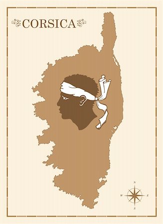
Old style map of corsica with Corsican emblem and compass rose, fully editable vector
Budget Royalty-Free & Subscription
-
abstract world map bubbles against white background, vector art illustration
Budget Royalty-Free & Subscription
-
Two globes on blue and brown stand insulated on white background
Budget Royalty-Free & Subscription
-
round logos with world map against white background, abstract vector art illustration
Budget Royalty-Free & Subscription
-

-