-

Satellite view of deforestation in East Rondonia, Brazil in 1986 and 2001. This before and after image shows deforestation impact over the years.
Rights-Managed
-

Color satellite image of Los Angeles International Airport, California, United States. Image collected on June 13, 2017 by Sentinel-2 satellites.
Rights-Managed
-

Color satellite image of Mumbai and Navi Mumbai, India. Navi Mumbai is a planned township located East of Mumbai. Both cities are connected by the Vashi bridge, also called Thane Creek Bridge. Image collected on May 03, 2017 by Sentinel-2 satellites.
Rights-Managed
-

-
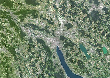
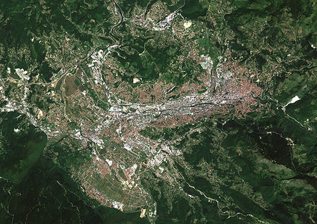
Colour satellite image of Zurich, Switzerland. Image taken on July 19, 2014 with Landsat 8 data.
Rights-Managed
-
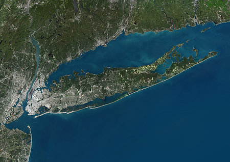
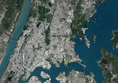
Color satellite image of Long Island, New York State, United States. Image collected on October 20, 2017 by Sentinel-2 satellites.
Rights-Managed
-
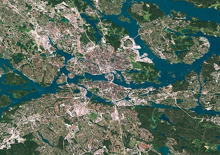
Color satellite image of Stockholm, capital city of Sweden. Image collected on July 06, 2017 by Sentinel-2 satellites.
Rights-Managed
-
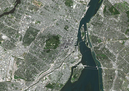
Color satellite image of Montreal, Quebec, Canada. The Saint Lawrence River flows through the city. Image collected on October 03, 2017 by Sentinel-2 satellites.
Rights-Managed
-
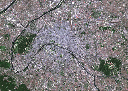
Color satellite image of Paris, capital city of France. The Seine River flows through the city. Image collected on May 26, 2017 by Sentinel-2 satellites.
Rights-Managed
-

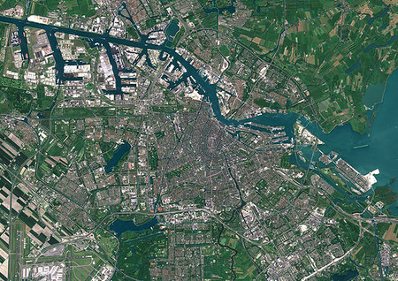
Colour satellite image of Amsterdam, Netherlands. Image taken on September 17, 2014 with Landsat 8 data.
Rights-Managed
-

Satellite view of Bahrain in 2002 and 2014. This before and after image shows urban expansion over the years.
Rights-Managed
-
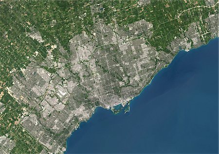
Colour satellite image of Toronto, Ontario, Canada. Image taken on August 19, 2014 with Landsat 8 data.
Rights-Managed
-

Color satellite image of New York City to Washington D.C. on the East Coast of the United States. Image collected on May 1, 2017 by Sentinel-2 satellites.
Rights-Managed
-
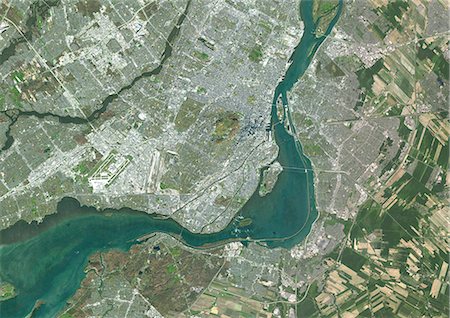
Colour satellite image of Montreal, Quebec, Canada. Image taken on November 11, 2014 with Landsat 8 data.
Rights-Managed
-
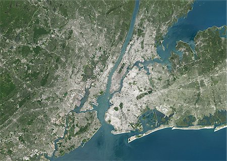
Colour satellite image of New York City, New York State, USA. Image taken on July 31, 2014 with Landsat 8 data.
Rights-Managed
-
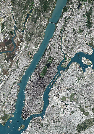
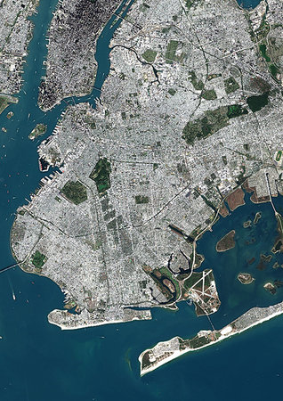
Color satellite image of Manhattan, New York City, New York State, United States. Manhattan is one borough of New York City. It is bound by Hudson River to the west, Harlem River to the north, and East River to the east. Central Park is in the center. Image collected on October 20, 2017 by Sentinel-2 satellites.
Rights-Managed
-

Color satellite image of East Coast from Massachusetts to Virginia, United States. Image collected on May 1, 2017 by Sentinel-2 satellites.
Rights-Managed
-

Color satellite image of Greater London, capital city of England and the United Kingdom. The River Thames flows through London. Image collected on April 09, 2017 by Sentinel-2 satellites.
Rights-Managed
-
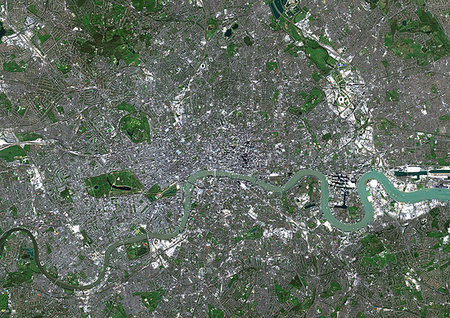
Color satellite image of London, capital city of England and the United Kingdom. The River Thames flows through London. Image collected on April 09, 2017 by Sentinel-2 satellites.
Rights-Managed
-
Color satellite image of Riyadh, capital city of Saudi Arabia. Image collected on October 23, 2017 by Sentinel-2 satellites.
Rights-Managed
-

Colour satellite image of Lagos, Nigeria. Image taken on January 19, 2014 with Landsat 8 data.
Rights-Managed
-
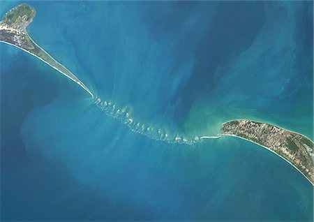
Satellite view of Adam's Bridge. This chain of limestone shoals connects Sri Lanka to India. This image was taken in 2014 by Landsat 8 satellite.
Rights-Managed
-

Colour satellite image of Abu Dhabi, United Arab Emirates. Image taken on December 16, 2013 with Landsat 8 data.
Rights-Managed
-

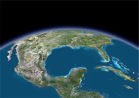
Color satellite image of Southern Florida, United States. It shows Miami at east, Everglades National Park at center, and the Florida Keys at south. Image collected on January 06, 2017 by Sentinel-2 satellites.
Rights-Managed
-

Color satellite image of Dublin, capital city of Ireland. Image collected on June 17, 2017 by Sentinel-2 satellites.
Rights-Managed
-
-
Color satellite image of Sarajevo, capital city of Bosnia and Herzegovina. Image collected on July 14, 2017 by Sentinel-2 satellites.
Rights-Managed
-

Color satellite image of Kigali, capital city of Rwanda. Image collected on August 31, 2016 by Sentinel-2 satellites.
Rights-Managed
-
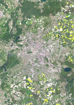
Colour satellite image of Berlin, Germany. Image taken on May 15, 2013 with Landsat 8 data.
Rights-Managed
-
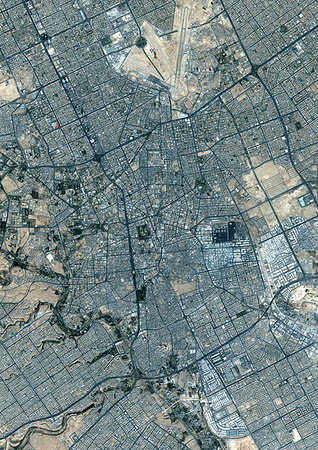
Color satellite image of Riyadh, capital city of Saudi Arabia. Image collected on October 23, 2017 by Sentinel-2 satellites.
Rights-Managed
-

Colour satellite image of New Orleans, Louisiana, USA. Image taken on November 3, 2014 with Landsat 8 data.
Rights-Managed
-
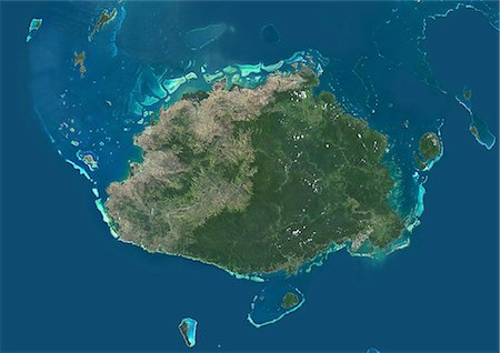
Satellite view of Viti Levu Island, Fiji. This is the largest island in the Republic of Fiji and the site of the nation's capital, Suva. This image was compiled from data acquired by Landsat 8 satellite in 2014.
Rights-Managed
-

Color satellite image of Jerusalem, capital city of Israel. Image collected on October 18, 2017 by Sentinel-2 satellites.
Rights-Managed
-
-

Satellite image of the Ganges River Delta, Bangladesh, India. Also known as the Brahmaputra Delta, it empties into the Bay of Bengal. Kolkata sits within the lower Ganges Delta along the Hooghly River (at west on the image). Image collected on March 16, 2017 by Sentinel-2 satellites.
Rights-Managed
-

Satellite view of Abu Dhabi, United Arab Emirates in 1985 and 2014. This before and after image shows urban expansion over the years.
Rights-Managed
-
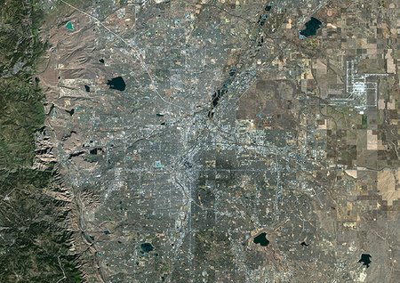
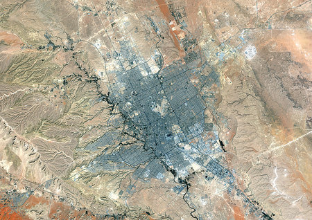
Color satellite image of Denver, Colorado, United States. Image collected on January 4, 2018 by Sentinel-2 satellites.
Rights-Managed
-

Color satellite image of Barcelona, Spain. Image collected on July 12, 2017 by Sentinel-2 satellites.
Rights-Managed
-

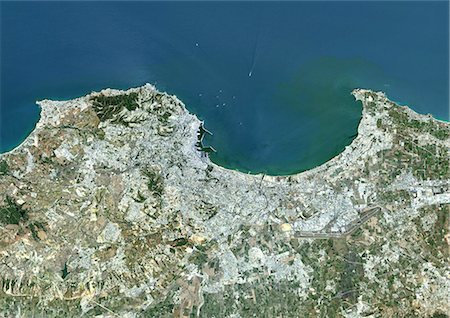
Colour satellite image of Oran, Algeria. Image taken on September 1, 2014 with Landsat 8 data.
Rights-Managed
-

Color satellite image of Occidental Glacier, Patagonia, Chile on May 24, 2016.
Rights-Managed
-

Colour satellite image of Cairo, Egypt. Image taken on December 16, 2013 with Landsat 8 data.
Rights-Managed
-

Satellite view of Chengdu, China in 1992 and 2013. This before and after image shows urban expansion over the years.
Rights-Managed
-
Color satellite image of Istanbul, Turkey. The city lies at the lower end of the Bosphorus Strait. Image collected on September 20, 2017 by Sentinel-2 satellites.
Rights-Managed
-

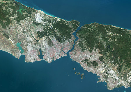
Color satellite image of the Bosphorus strait, Turkey. Istanbul lies at the lower end of the Bosphorus. Image collected on September 20, 2017 by Sentinel-2 satellites.
Rights-Managed
-
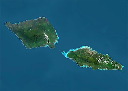
Satellite view of Samoa that consists of two large islands, Upolu and Savaii. This image was compiled from data acquired by Landsat 8 satellite in 2014.
Rights-Managed
-

Satellite view of Shanghai, China in 1979, 2001 and 2013. This before and after image shows urban expansion over the years.
Rights-Managed
-
Colour satellite image of Algiers, Algeria. Image taken on July 17, 2014 with Landsat 8 data.
Rights-Managed
-
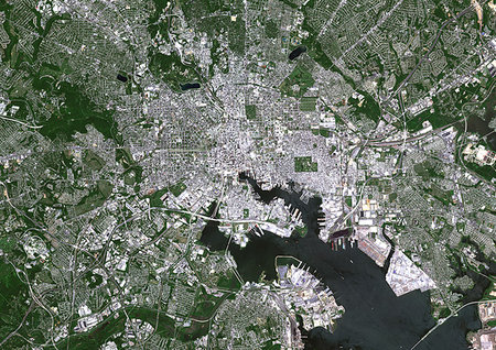
Color satellite image of Baltimore, Maryland, United States. Image collected on May 16, 2017 by Sentinel-2 satellites.
Rights-Managed
-

-

-
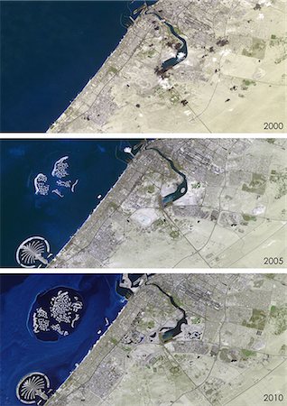
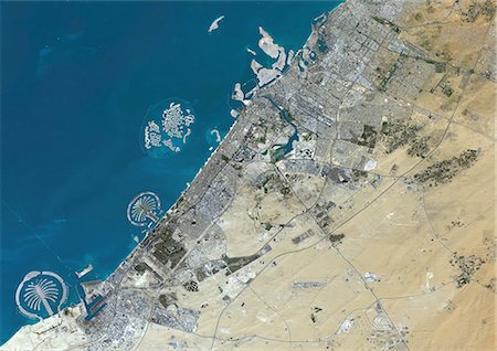
Satellite view of Dubai, United Arab Emirates in 2000, 2005 and 2010. This before and after image shows urban expansion over the years and the construction of the World Islands and the Palm island called Palm Jumeirah.
Rights-Managed
-

Colour satellite image of Luanda, Angola. Image taken on May 28, 2014 with Landsat 8 data.
Rights-Managed
-

The sun rising above the earths surface. NO NASA maps or files used in the creation of this image.
Budget Royalty-Free & Subscription
-

Planet earth with the sun rising. Thousands of street lights can be seen on the surface. NO NASA maps or files used in this image. All source images are my own work.
Budget Royalty-Free & Subscription
-

-

Night view of Asia from the satellite to the glowing lights of towns on the sunrise from the east
Budget Royalty-Free & Subscription
-

-

-

Sunlight breaking over the planet earth. NO NASA files or maps used in this image. ALL elements are sourced from my own images including textures.
Budget Royalty-Free & Subscription
-

Color satellite image of the East Coast from Massachusetts to Northern Carolina, United States. Image collected on May 1, 2017 by Sentinel-2 satellites.
Rights-Managed
-

-
Colour satellite image of Dubai, United Arab Emirates. Image taken on December 25, 2013 with Landsat 8 data.
Rights-Managed
-

Colour satellite image of Muscat, Oman. Image taken on December 27, 2013 with Landsat 8 data.
Rights-Managed
-
Color satellite image of the Bronx, New York City, New York State, United States. The Bronx is one borough of New York City. It lies north and east of Manhattan, across the Harlem River. Image collected on October 20, 2017 by Sentinel-2 satellites.
Rights-Managed
-
Color satellite image of Brooklyn, New York City, New York State, United States. Brooklyn is one borough of New York City. It lies at the southwestern end of Long Island. Image collected on October 20, 2017 by Sentinel-2 satellites.
Rights-Managed
-
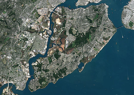
Color satellite image of Staten Island, New York City, New York State, United States. Staten Island is one borough of New York City. It is separated from the rest of New York by New York Bay. Image collected on October 20, 2017 by Sentinel-2 satellites.
Rights-Managed
-
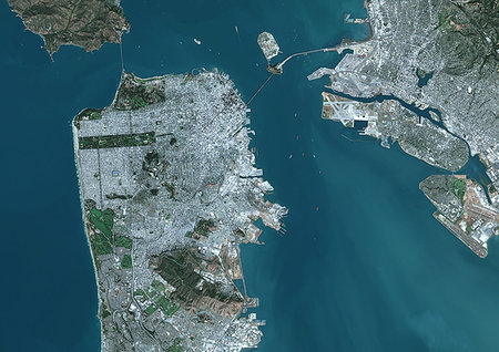
Color satellite image of San Francisco, California, United States. The Bay Bridge connects San Francisco with Oakland at east. Image collected on September 27, 2017 by Sentinel-2 satellites.
Rights-Managed
-

Color satellite image of Mountain View, California, United States. The city is located in the San Francisco Bay Area. Image collected on September 27, 2017 by Sentinel-2 satellites.
Rights-Managed
-
Color satellite image of Zagreb, capital city of Croatia. Image collected on August 26, 2017 by Sentinel-2 satellites.
Rights-Managed
-

Color satellite image of Perth, Australia. Image collected on August 25, 2017 by Sentinel-2 satellites.
Rights-Managed
-
Color satellite image of Tirana, capital city of Albania. Image collected on July 11, 2017 by Sentinel-2 satellites.
Rights-Managed
-
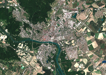
Color satellite image of Bratislava, capital city of Slovakia. The city is crossed by the Danube River. Image collected on June 20, 2017 by Sentinel-2 satellites.
Rights-Managed
-
Color satellite image of Amsterdam, capital city of Netherlands. The River Amstel flows through the city. Image collected on May 26, 2017 by Sentinel-2 satellites.
Rights-Managed
-
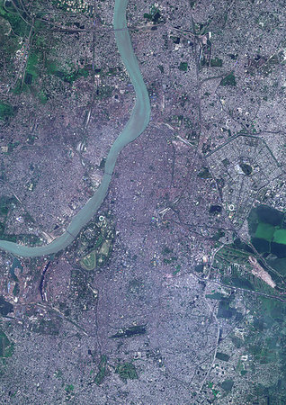
Color satellite image of Kolkata, India. The city is located on the east bank of the Hooghly River. Image collected on March 16, 2017 by Sentinel-2 satellites.
Rights-Managed
-

Satellite image of the Ganges River Delta, Bangladesh, India. Also known as the Brahmaputra Delta, it empties into the Bay of Bengal. Kolkata sits within the lower Ganges Delta along the Hooghly River (at west on the image). Image collected on March 16, 2017 by Sentinel-2 satellites.
Rights-Managed
-

Color satellite image of Rio de Janeiro, Brazil. Image collected on March 10, 2017 by Sentinel-2 satellites.
Rights-Managed
-

Color satellite image of Lake Ontario, North America. Image collected on May 1, 2016 by Landsat 8 satellite.
Rights-Managed
-
-

Colour satellite image of Las Vegas, Nevada, USA. Image taken on September 23, 2014 with Landsat 8 data.
Rights-Managed
-

Satellite view of Foshan and Guangzhou, China in 1990 and 2013. This before and after image shows urban expansion over the years.
Rights-Managed
-

Colour satellite image of Montreal, Quebec, Canada. Image taken on November 11, 2014 with Landsat 8 data.
Rights-Managed
-

Satellite view of deforestation in Matto Grosso, Brazil in 1985 and 2000. This before and after image shows deforestation impact over the years.
Rights-Managed
-

-
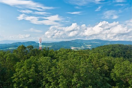
Blue sky in contact with the transmitter protuberant above forest
Budget Royalty-Free & Subscription
-

Sunlight breaking over the planet earth. NO NASA files or maps used in this image. ALL elements are sourced from my own images including textures.
Budget Royalty-Free & Subscription
-

-

-

Planet earth with the sun rising. NO NASA maps or files used in this image. All source images are my own work.
Budget Royalty-Free & Subscription
-

Earth rising over the Moon. No NASA maps or files used in this image.
Budget Royalty-Free & Subscription
-

Satellite flying in deep space and three planets on the background. Also available as a Vector in Adobe illustrator EPS 8 format, compressed in a zip file.
Budget Royalty-Free & Subscription


