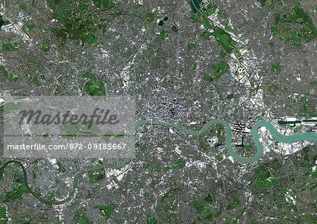
Color satellite image of London, capital city of England and the United Kingdom. The River Thames flows through London. Image collected on April 09, 2017 by Sentinel-2 satellites.
Introductory Offer
Save 50% when you join our email list
-
Web Resolution
550×389px
7.6×5.4in 72ppi
-
Low Resolution
1007×712px
14.0×9.9in 72ppi
-
Medium Resolution
2229×1576px
7.4×5.3in 300ppi
-
High Resolution
4961×3508px
16.5×11.7in 300ppi
* Final price based on usage, not file size.
Related Keywords
- 872-
- aerial view
- Bayswater
- Camden
- capital city
- cartographic
- Chelsea
- city
- color image
- color photography
- color picture
- East End
- England
- Europe
- European
- European (places and things)
- Fulham
- Great Britain
- Hammersmith
- Hyde Park
- image
- Islington
- Kensington
- London
- London Borough of Camden
- London Borough of Hackney
- Marylebone
- no people
- Notting Hill
- outdoors
- photograph
- photographic (pertaining to the discipline of photography)
- photography
- picture
- river
- satellite view
- South Bank
- Southwark
- stock photograph
- stock picture
- Thames River
- United Kingdom
- Universal Images Group
- West End
- Westminster
Related Images
- Color satellite image of Greater London, capital city of England and the United Kingdom. The River Thames flows through London. Image collected on April 09, 2017 by Sentinel-2 satellites.
- Color satellite image of Montevideo, capital city of Uruguay. Image collected on December 12, 2016 by Sentinel-2 satellites.
- Color satellite image of Asuncion, capital city of Paraguay. Image collected on June 23, 2017 by Sentinel-2 satellites.
- Color satellite image of Washington D.C., capital of the United States. The south bank of the Potomac River forms the District of Columbia's border with Virginia. Image collected on May 16, 2017 by Sentinel-2 satellites.
- Color satellite image of Ottawa, capital city of Canada. It stands on the south bank of the Ottawa River. Image collected on October 03, 2017 by Sentinel-2 satellites.
- Color satellite image of Baghdad, capital city of Iraq, located along the Tigris River. Image collected on October 16, 2017 by Sentinel-2 satellites.
- Color satellite image of Cairo, capital city of Egypt. Image collected on October 01, 2017 by Sentinel-2 satellites.
- Color satellite image of Kiev, capital city of Ukraine. Kiev is located on both sides of the Dnieper River. Image collected on August 11, 2017 by Sentinel-2 satellites.
More Related Images
- Color satellite image of Bratislava, capital city of Slovakia. The city is crossed by the Danube River. Image collected on June 20, 2017 by Sentinel-2 satellites.
- Color satellite image of Belgrade, capital city of Serbia. It is located at the confluence of the Danube and Sava rivers. Image collected on October 02, 2017 by Sentinel-2 satellites.
- Color satellite image of Lisbon, capital city of Portugal. It is situated at the mouth of the Tagus River. Image collected on September 02, 2017 by Sentinel-2 satellites.
- Color satellite image of Amsterdam, capital city of Netherlands. The River Amstel flows through the city. Image collected on May 26, 2017 by Sentinel-2 satellites.
- Color satellite image of Riga, capital city of Latvia. Image collected on May 28, 2017 by Sentinel-2 satellites.
- Color satellite image of Rome, capital city of Italy. The Tiber flows through the city. Image collected on July 30, 2017 by Sentinel-2 satellites.
- Color satellite image of Budapest, capital city of Hungary. The Danube River flows through the city. Image collected on October 02, 2017 by Sentinel-2 satellites.
- Color satellite image of Greater Paris, capital city of France. Image collected on May 26, 2017 by Sentinel-2 satellites.

