238,163 immagini per simSearch:872-06054387,k

  • 872-06160297

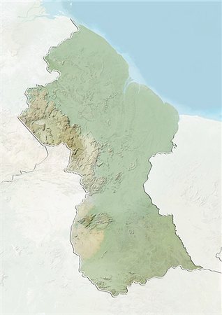
    Relief map of Guyana (with border and mask). This image was compiled from data acquired by landsat 5 & 7 satellites combined with elevation data.

    Rights-Managed

  • 872-06054388

    Guyana, Relief Map With Border

    Rights-Managed

  • 872-06054387

    Guyana, Relief Map With Border and Mask

    Rights-Managed

  • 872-06054390

    Guyana, Satellite Image With Bump Effect, With Border

    Rights-Managed

  • 872-06054389

    Guyana, Satellite Image With Bump Effect, With Border and Mask

    Rights-Managed

  • 872-06160452

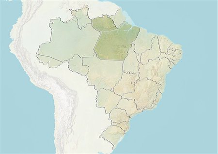
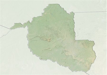
    Relief map of the State of Amapa, Brazil. This image was compiled from data acquired by LANDSAT 5 & 7 satellites combined with elevation data.

    Rights-Managed

  • 872-06160394

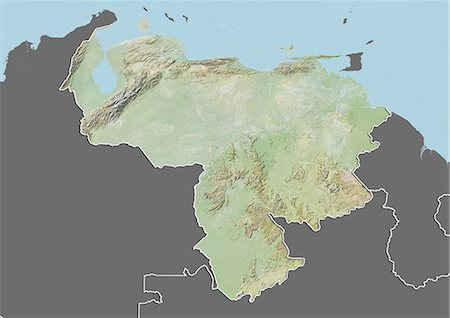
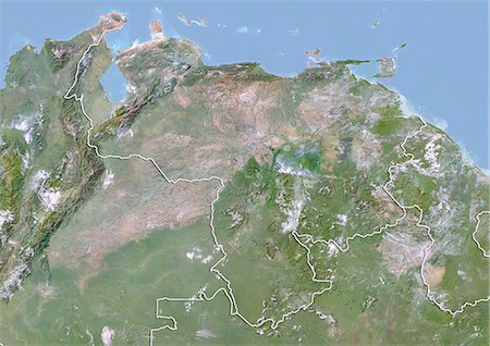
    Relief map of Venezuela (with border and mask). This image was compiled from data acquired by landsat 5 & 7 satellites combined with elevation data.

    Rights-Managed

  • 872-06160370

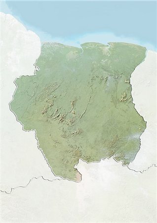
    Relief map of Suriname (with border and mask). This image was compiled from data acquired by landsat 5 & 7 satellites combined with elevation data.

    Rights-Managed

  • 872-06160350

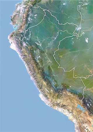
    Relief map of Peru (with border and mask). This image was compiled from data acquired by landsat 5 & 7 satellites combined with elevation data.

    Rights-Managed

  • 872-06160279

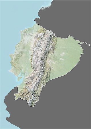
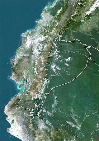
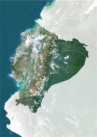
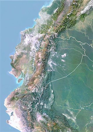
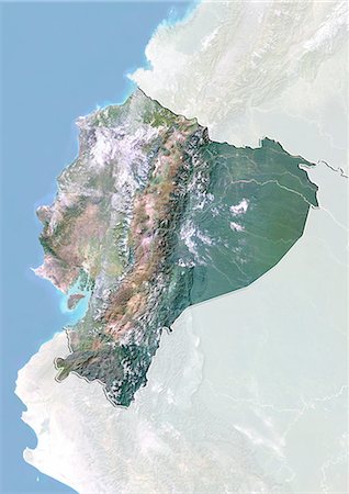
    Relief map of Equator (with border and mask). This image was compiled from data acquired by landsat 5 & 7 satellites combined with elevation data.

    Rights-Managed

  • 872-06160257

    Relief map of Brazil (with border and mask). This image was compiled from data acquired by landsat 5 & 7 satellites combined with elevation data.

    Rights-Managed

  • 872-06055084

    Brazil, Relief Map With Boundaries of States

    Rights-Managed

  • 872-06055036

    Brazil and the State of Amapa, Relief Map

    Rights-Managed

  • 872-06054879

    Venezuela, Relief Map with Border

    Rights-Managed

  • 872-06054878

    Venezuela, Relief Map with Border and Mask

    Rights-Managed

  • 872-06054781

    Suriname, Relief Map with Border

    Rights-Managed

  • 872-06054780

    Suriname, Relief Map with Border and Mask

    Rights-Managed

  • 872-06054664

    Peru, Relief Map With Border

    Rights-Managed

  • 872-06054663

    Peru, Relief Map With Border and Mask

    Rights-Managed

  • 872-06054289

    Ecuador, Relief Map With Border

    Rights-Managed

  • 872-06054288

    Ecuador, Relief Map With Border and Mask

    Rights-Managed

  • 872-06054163

    Brazil, Relief Map With Border

    Rights-Managed

  • 872-06054162

    Brazil, Relief Map With Border and Mask

    Rights-Managed

  • 872-08689471

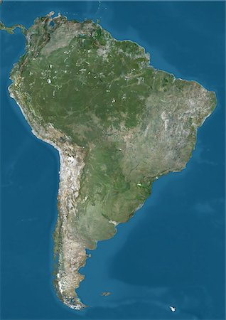
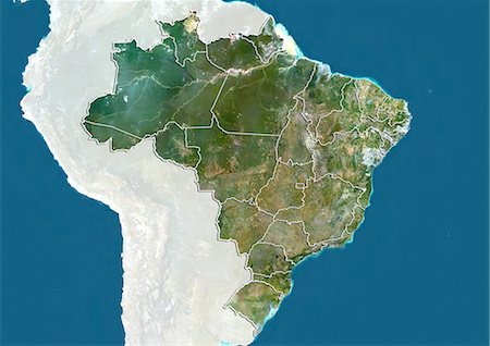
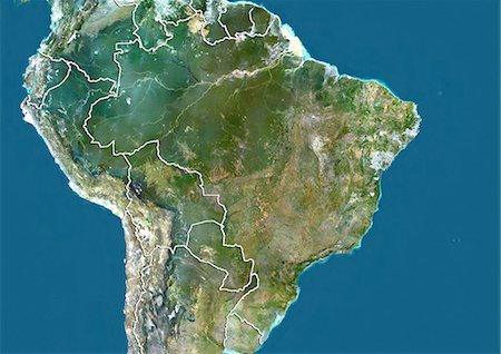
    Satellite view of South America. This image was compiled from data acquired by Landsat 7 & 8 satellites.

    Rights-Managed

  • 872-06160500

    Relief map of the State of Tocantins, Brazil. This image was compiled from data acquired by LANDSAT 5 & 7 satellites combined with elevation data.

    Rights-Managed

  • 872-06160474

    Relief map of the State of Para, Brazil. This image was compiled from data acquired by LANDSAT 5 & 7 satellites combined with elevation data.

    Rights-Managed

  • 872-06160470

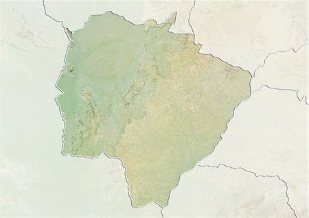
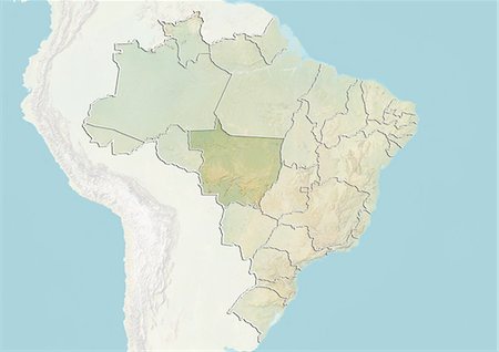
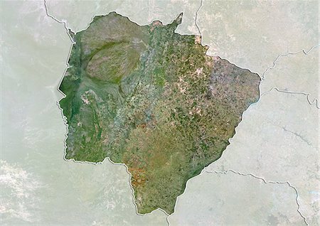
    Relief map of the State of Mato Grosso do Sul, Brazil. This image was compiled from data acquired by LANDSAT 5 & 7 satellites combined with elevation data.

    Rights-Managed

  • 872-06160454

    Relief map of the State of Amazonas, Brazil. This image was compiled from data acquired by LANDSAT 5 & 7 satellites combined with elevation data.

    Rights-Managed

  • 872-06160453

    Satellite view of the State of Amapa, Brazil. This image was compiled from data acquired by LANDSAT 5 & 7 satellites.

    Rights-Managed

  • 872-06055085

    Brazil, True Colour Satellite Image With Boundaries of States

    Rights-Managed

  • 872-06055082

    Brazil and the State of Tocantins, Relief Map

    Rights-Managed

  • 872-06055074

    Brazil and the State of Roraima, Relief Map

    Rights-Managed

  • 872-06055056

    Brazil and the State of Para, Relief Map

    Rights-Managed

  • 872-06055050

    Brazil and the State of Mato Grosso, Relief Map

    Rights-Managed

  • 872-06055038

    Brazil and the State of Amazonas, Relief Map

    Rights-Managed

  • 872-06055037

    Brazil and the State of Amapa, True Colour Satellite Image

    Rights-Managed

  • 872-06054883

    Venezuela, True Colour Satellite Image With Border

    Rights-Managed

  • 872-06054882

    Venezuela, True Colour Satellite Image With Border and Mask

    Rights-Managed

  • 872-06054881

    Venezuela, Satellite Image With Bump Effect, With Border

    Rights-Managed

  • 872-06054880

    Venezuela, Satellite Image With Bump Effect, With Border and Mask

    Rights-Managed

  • 872-06054785

    Suriname, True Colour Satellite Image With Border

    Rights-Managed

  • 872-06054784

    Suriname, True Colour Satellite Image With Border and Mask

    Rights-Managed

  • 872-06054783

    Suriname, Satellite Image With Bump Effect, With Border

    Rights-Managed

  • 872-06054782

    Suriname, Satellite Image With Bump Effect, With Border and Mask

    Rights-Managed

  • 872-06054668

    Peru, True Colour Satellite Image With Border

    Rights-Managed

  • 872-06054667

    Peru, True Colour Satellite Image With Border and Mask

    Rights-Managed

  • 872-06054666

    Peru, Satellite Image With Bump Effect, With Border

    Rights-Managed

  • 872-06054665

    Peru, Satellite Image With Bump Effect, With Border and Mask

    Rights-Managed

  • 872-06054293

    Ecuador, True Colour Satellite Image With Border

    Rights-Managed

  • 872-06054292

    Ecuador, True Colour Satellite Image With Border and Mask

    Rights-Managed

  • 872-06054291

    Ecuador, Satellite Image With Bump Effect, With Border

    Rights-Managed

  • 872-06054290

    Ecuador, Satellite Image With Bump Effect, With Border and Mask

    Rights-Managed

  • 872-06054165

    Brazil, True Colour Satellite Image With Border

    Rights-Managed

  • 872-06054164

    Brazil, True Colour Satellite Image With Border and Mask

    Rights-Managed

  • 872-06160501

    Satellite view of the State of Tocantins, Brazil. This image was compiled from data acquired by LANDSAT 5 & 7 satellites.

    Rights-Managed

  • 872-06160475

    Satellite view of the State of Para, Brazil. This image was compiled from data acquired by LANDSAT 5 & 7 satellites.

    Rights-Managed

  • 872-06160471

    Satellite view of the State of Mato Grosso do Sul, Brazil. This image was compiled from data acquired by LANDSAT 5 & 7 satellites.

    Rights-Managed

  • 872-06160455

    Satellite view of the State of Amazonas, Brazil. This image was compiled from data acquired by LANDSAT 5 & 7 satellites.

    Rights-Managed

  • 872-06160269

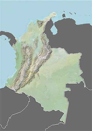
    Relief map of Colombia (with border and mask). This image was compiled from data acquired by landsat 5 & 7 satellites combined with elevation data.

    Rights-Managed

  • 872-06055083

    Brazil and the State of Tocantins, True Colour Satellite Image

    Rights-Managed

  • 872-06055075

    Brazil and the State of Roraima, True Colour Satellite Image

    Rights-Managed

  • 872-06055057

    Brazil and the State of Para, True Colour Satellite Image

    Rights-Managed

  • 872-06055051

    Brazil and the State of Mato Grosso, True Colour Satellite Image

    Rights-Managed

  • 872-06055039

    Brazil and the State of Amazonas, True Colour Satellite Image

    Rights-Managed

  • 872-06054227

    Colombia, Relief Map With Border

    Rights-Managed

  • 872-06054226

    Colombia, Relief Map With Border and Mask

    Rights-Managed

  • 872-06160491

    Relief map of the State of Rondonia, Brazil. This image is from 2003 and compiled from data acquired by LANDSAT 7 satellite combined with elevation data.

    Rights-Managed

  • 872-06160490

    Relief map of the State of Rondonia, Brazil. This image is from 1990 and compiled from data acquired by LANDSAT 5 satellite combined with elevation data.

    Rights-Managed

  • 872-06160448

    Relief map of the State of Acre, Brazil. This image was compiled from data acquired by LANDSAT 5 & 7 satellites combined with elevation data.

    Rights-Managed

  • 872-06160303

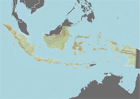
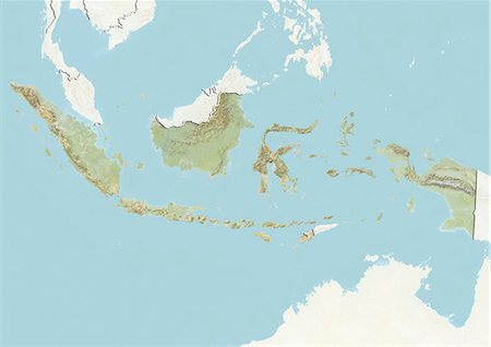
    Relief map of Indonesia (with border and mask). This image was compiled from data acquired by landsat 5 & 7 satellites combined with elevation data.

    Rights-Managed

  • 872-06160281

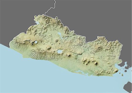
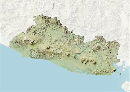
    Relief map of El Salvador (with border and mask). This image was compiled from data acquired by landsat 5 & 7 satellites combined with elevation data.

    Rights-Managed

  • 872-06160254

    Relief map of Bolivia (with border and mask). This image was compiled from data acquired by landsat 5 & 7 satellites combined with elevation data.

    Rights-Managed

  • 872-06055072

    Brazil and the State of Rondonia, Relief Map

    Rights-Managed

  • 872-06055032

    Brazil and the State of Acre, Relief Map

    Rights-Managed

  • 872-06054416

    Indonesia, Relief Map With Border

    Rights-Managed

  • 872-06054415

    Indonesia, Relief Map With Border and Mask

    Rights-Managed

  • 872-06054299

    El Salvador, Relief Map With Border

    Rights-Managed

  • 872-06054298

    El Salvador, Relief Map With Border and Mask

    Rights-Managed

  • 872-06054231

    Colombia, True Colour Satellite Image With Border

    Rights-Managed

  • 872-06054230

    Colombia, True Colour Satellite Image With Border and Mask

    Rights-Managed

  • 872-06054229

    Colombia, Satellite Image With Bump Effect, With Border

    Rights-Managed

  • 872-06054228

    Colombia, Satellite Image With Bump Effect, With Border and Mask

    Rights-Managed

  • 872-06054147

    Bolivia, Relief Map With Border

    Rights-Managed

  • 872-06054146

    Bolivia, Relief Map With Border and Mask

    Rights-Managed

  • 872-06053509

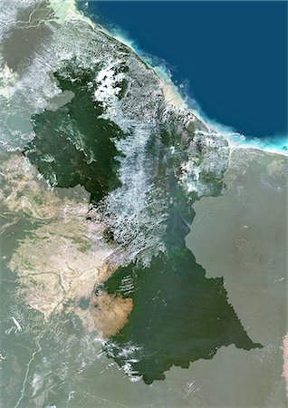
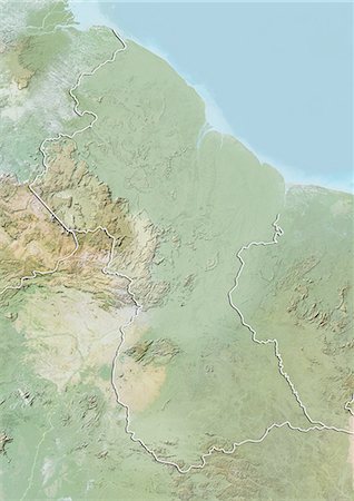
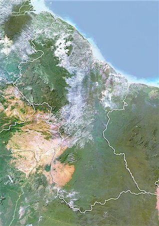
    Guyana, South America, True Colour Satellite Image With Mask. Satellite view of Guyana (with mask). This image was compiled from data acquired by LANDSAT 5 & 7 satellites.

    Rights-Managed

  • 872-06053180

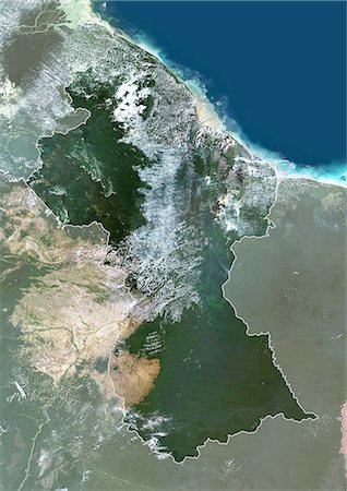
    Guyana, South America, True Colour Satellite Image With Border And Mask. Satellite view of Guyana (with border and mask). This image was compiled from data acquired by LANDSAT 5 & 7 satellites.

    Rights-Managed

  • 872-06053179

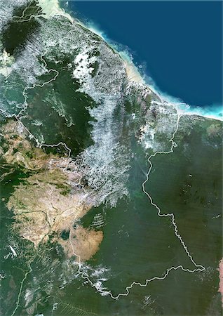
    Guyana, South America, True Colour Satellite Image With Border. Satellite view of Guyana (with border). This image was compiled from data acquired by LANDSAT 5 & 7 satellites.

    Rights-Managed

  • 872-06160498

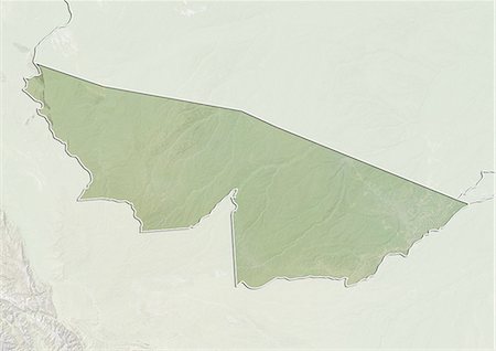
    Relief map of the State of Sergipe, Brazil. This image was compiled from data acquired by LANDSAT 5 & 7 satellites combined with elevation data.

    Rights-Managed

  • 872-06160496

    Relief map of the State of Sao Paulo, Brazil. This image was compiled from data acquired by LANDSAT 5 & 7 satellites combined with elevation data.

    Rights-Managed

  • 872-06160494

    Relief map of the State of Santa Catarina, Brazil. This image was compiled from data acquired by LANDSAT 5 & 7 satellites combined with elevation data.

    Rights-Managed