-

Saltpan Meteor Impact Crater, Pretoria, South Africa, True Colour Satellite Image. True colour satellite image of Saltpan impact structure, Pretoria, South Africa (diameter : 1,13 km). Image taken on 7 September 1991 using LANDSAT data.
Rights-Managed
-
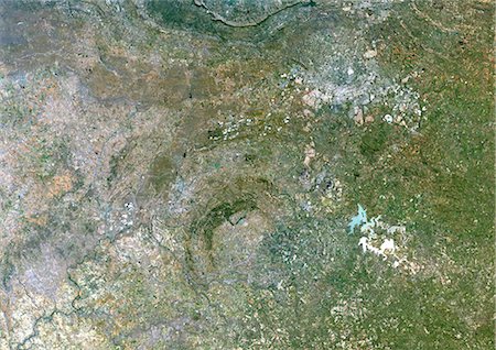
Vredefort Meteor Impact Crater, South Africa, True Colour Satellite Image. True colour satellite image of Vredefort impact structure, South Africa (diameter : 140 km). Composite image of LANDSAT data taken on 7 April 1991 and 30 April 1991.
Rights-Managed
-
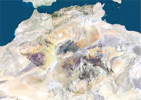
Tin Bider Meteor Impact Crater, Algeria, True Colour Satellite Image. True colour satellite image of Tin Bider impact structure, Algeria (age : 70 million years ; diameter : 6 km). Image taken on 19 February 1988 using LANDSAT data.
Rights-Managed
-

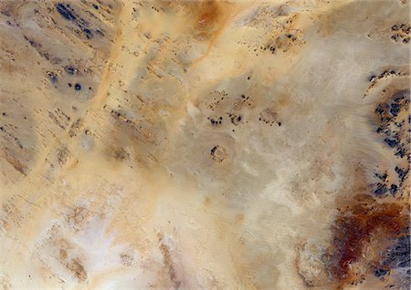
Talemzane Meteor Impact Crater, Algeria, True Colour Satellite Image. True colour satellite image of Talemzane impact structure, Algeria (age : 3 million years ; diameter : 1,75 km). Image taken on 3 March 1987 using LANDSAT data.
Rights-Managed
-
Meteor Impact Crater, Libya, True Colour Satellite Image. True colour satellite image of an impact structure North of Koufra Oasis (24 06'N - 23 24'E), in the Libyan desert. Image taken on 9 November 1986 using LANDSAT data.
Rights-Managed
-
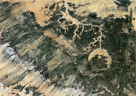
Gweni Fada Meteor Impact Crater, Chad, True Colour Satellite Image. True colour satellite image of Gweni-Fada impact structure, Chad (diameter : 14 km). Image taken on 19 January 1987 using LANDSAT data.
Rights-Managed
-

Meteor Impact Crater In The Libyan Desert, Egypt, True Colour Satellite Image. True colour satellite image of an impact structure in the Libyan desert, Egypt. Image taken on 9 November 1986 using LANDSAT data.
Rights-Managed
-

Bosumtwi Meteor Impact Crater, Ghana, True Colour Satellite Image. True colour satellite image of Bosumtwi impact structure, Ghana (diameter : 10,5 km). Composite image of LANDSAT data taken on 11 January 1986 and 29 December 1986.
Rights-Managed
-

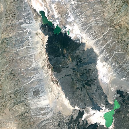
Aouelloul Meteor Impact Crater, Mauritania, True Colour Satellite Image. True colour satellite image of Aouelloul impact structure, Mauritania (diameter : 390 m). Image taken on 13 January 1987 using LANDSAT data.
Rights-Managed
-

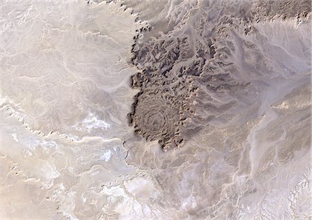
Aorounga Meteor Impact Crater, Chad, True Colour Satellite Image. True colour satellite image of Aorounga impact structure, Chad (age : 200 million years ; diameter : 17 km). Image taken on 22 February 1988 using LANDSAT data.
Rights-Managed
-

Amguid Meteor Impact Crater, Algeria, True Colour Satellite Image. True colour satellite image of Amguid impact structure, Algeria (age : 100 000 years ; diameter : 450 m). Image taken on 19 February 1988 using LANDSAT data.
Rights-Managed
-

Piton De La Fournaise Volcano In 3D, Reunion Island, French Overseas, True Colour Satellite Image. Piton de la Fournaise, Reunion, true colour satellite image. 3D satellite view of the Piton de la Fournaise (2631m), one of the world's most active volcanoes, located on the South East part of Reunion Island, in the Indian Ocean. Image using LANDSAT data.
Rights-Managed
-

Ardoukoba Volcano, Djibouti, True Colour Satellite Image. Ardoukoba, Djibouti, true colour satellite image. Ardoukoba is a volcano located close to Assal Lake in Djibouti. Image taken on 13 May 2000 using LANDSAT data. Print size 30 x 30 cm.
Rights-Managed
-

Tousside Volcano, Chad, True Colour Satellite Image. Tousside volcano, Chad, true colour satellite image. Tousside is a volcano (3265m) in the North-West part of Chad. Composite image dated 2001 using LANDSAT data. Print size 30 x 30 cm.
Rights-Managed
-

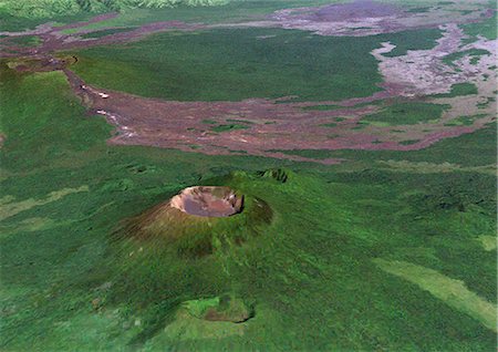
Ol Doinyo Lengai Volcano, Tanzania, True Colour Satellite Image. Lengai, Tanzanie, true colour satellite image. The active volcano Ol Doinyo Lengai (2890m), whose summit is partly covered with clouds, is at the bottom part of the image. North is Lake Natron. Composite image dated 2000 using LANDSAT data. Print size 30 x 30 cm.
Rights-Managed
-

Piton De La Fournaise Volcano, Reunion Island, French Overseas, True Colour Satellite Image. Piton de la Fournaise, Reunion island, French overseas, true colour satellite image. Piton de la Fournaise (2631m), one of the world's most active volcanoes, is located on the South East part of Reunion Island, in the Indian Ocean. Image taken on 19 June 2000 using LANDSAT data. Print size 30 x 30 cm.
Rights-Managed
-
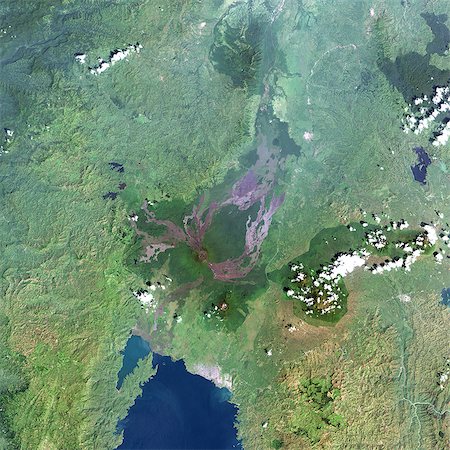
Nyiragongo Volcano, Democratic Republic Of Congo, True Colour Satellite Image. Nyiragongo, Congo, true colour satellite image. Nyiragongo is one of the most active volcanoes in Africa, located about 10 km from the city of Goma. Image taken on 11 December 2001 using LANDSAT data. Print size 30 x 30 cm.
Rights-Managed
-
Erta Ale Volcano, Ethiopia, True Colour Satellite Image. Erta Ale volcano, Ethiopia, true colour satellite image. Erta Ale (613m) is a shield volcano in the Afar region of East Africa. Image taken on 5 February 2002 using LANDSAT data. Print size 30 x 30 cm.
Rights-Managed
-
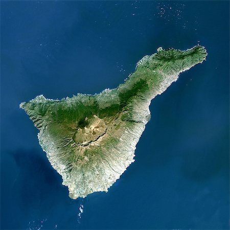
Teide Volcano, Canary Islands, Spain, True Colour Satellite Image. Teide volcano, Spain, true colour satellite image. Teide Volcano (3718 m) on the island of Tenerife in the Canary Islands is the highest peak in Spain. Composite image dated 2000-2001 using LANDSAT data. Print size 30 x 30 cm.
Rights-Managed
-
Volcano Nyiragongo In 3D, Democratic Republic Of Congo, True Colour Satellite Image. Nyiragongo, Congo, true colour satellite image. Nyiragongo is one of Africa's most active volcano, located 10km from the town of Goma. Image taken on 11 December 2001 using LANDSAT data.
Rights-Managed
-
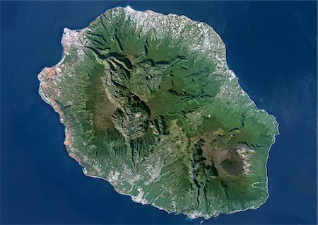
Piton De La Fournaise, Reunion Island, French Overseas, True Colour Satellite Image. Reunion Island, French overseas, true colour satellite image. Reunion island is made of two volcanos, Piton des Neiges volcano, the highest point on the island at 3069m, and Piton de la Fournaise (2632m), an active shield volcano on the Eastern end of Reunion Island. Image taken on 19 June 2000 using LANDSAT data.
Rights-Managed
-
South Africa, True Colour Satellite Image With Mask And Border. South Africa, true colour satellite image with mask and border. This image was compiled from data acquired by LANDSAT 5 & 7 satellites.
Rights-Managed
-

South Africa, True Colour Satellite Image With Border. South Africa, true colour satellite image with border. This image was compiled from data acquired by LANDSAT 5 & 7 satellites.
Rights-Managed
-

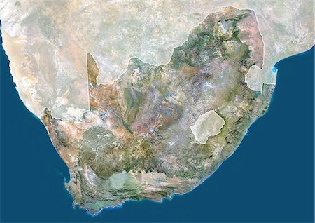
South Africa, True Colour Satellite Image. South Africa, true colour satellite image. This image was compiled from data acquired by LANDSAT 5 & 7 satellites.
Rights-Managed
-

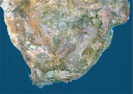
South Africa, True Colour Satellite Image With Mask. South Africa, true colour satellite image with mask. This image was compiled from data acquired by LANDSAT 5 & 7 satellites.
Rights-Managed
-
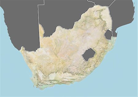
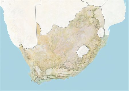
Relief map of South Africa (with border and mask). This image was compiled from data acquired by landsat 5 & 7 satellites combined with elevation data.
Rights-Managed
-
-

-

-
-
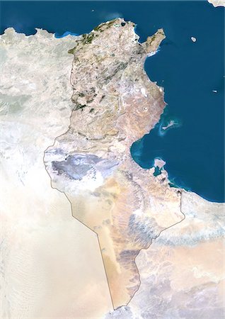
Tunisia, True Colour Satellite Image With Mask And Border. Tunisia, true colour satellite image with mask and border. North is at top. Around forty-five percent of the country is composed of the Sahara desert, with much of the remainder consisting of particularly fertile soil, with easily accessible coasts. This image was compiled from data acquired by LANDSAT 5 & 7 satellites.
Rights-Managed
-

Tunisia, True Colour Satellite Image With Border. Tunisia, true colour satellite image with border. North is at top. Around forty-five percent of the country is composed of the Sahara desert, with much of the remainder consisting of particularly fertile soil, with easily accessible coasts. This image was compiled from data acquired by LANDSAT 5 & 7 satellites.
Rights-Managed
-
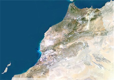
Morocco, True Colour Satellite Image With Mask And Border. Morocco. True colour satellite image of Morocco, with mask and border. The Strait of Gibraltar is at top center. The Mediterranean Sea is to the east of this strait, with the Atlantic Ocean to the west. This image was compiled from data acquired by LANDSAT 5 & 7 satellites.
Rights-Managed
-
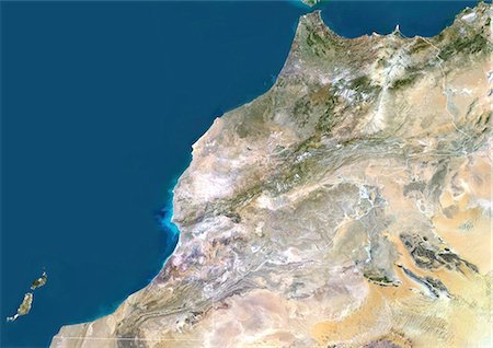
Morocco, True Colour Satellite Image With Border. Morocco. True colour satellite image of Morocco, with border. The Strait of Gibraltar is at top center. The Mediterranean Sea is to the east of this strait, with the Atlantic Ocean to the west. This image was compiled from data acquired by LANDSAT 5 & 7 satellites.
Rights-Managed
-
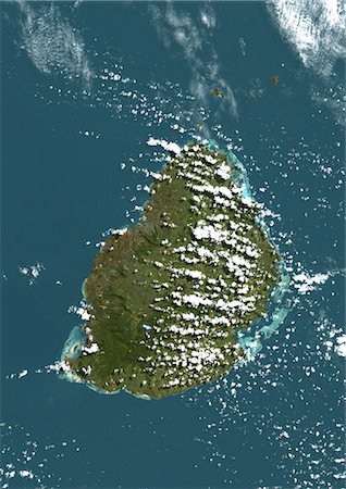
Mauritius, True Colour Satellite Image. Mauritius, true colour satellite image, taken on 19 August 1999, by the LANDSAT 7 satellite.
Rights-Managed
-
-

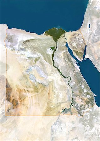
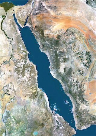
Egypt, True Colour Satellite Image With Border. Egypt, true colour satellite image with border. North is at top. In the center of the image is the Nile Delta, its lush vegetation following the path of the river. To the east of the Nile is the Gulf of Suez, which runs down the western side of the Sinai Peninsula. This image was compiled from data acquired by LANDSAT 5 & 7 satellites.
Rights-Managed
-
-

-

Marrakech, Morocco, True Colour Satellite Image. True colour satellite image of Marrakech, Morocco. Composite image using LANDSAT 7 data.
Rights-Managed
-
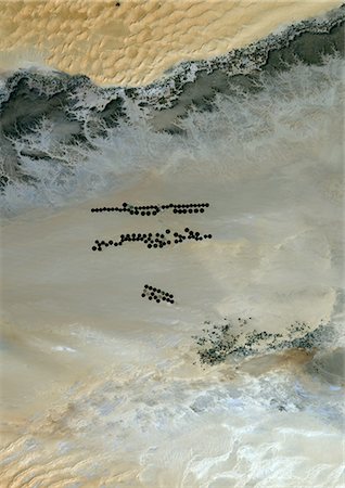
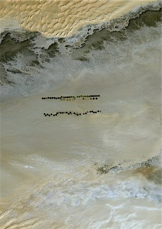
Agriculture In The Murzuq Desert In 2005, Libya, True Colour Satellite Image. True colour satellite image of agriculture in the northern Murzuq Desert in Libya. The Murzuq Desert is an erg desert, part of the Sahara desert, in southwestern Libya. Circular agricultural plots are visible on the image. Image taken on 11 March 2005, using LANDSAT 7 data.
Rights-Managed
-

Agriculture In The Murzuq Desert In 2000, Libya, True Colour Satellite Image. True colour satellite image of agriculture in the northern Murzuq Desert in Libya. The Murzuq Desert is an erg desert, part of the Sahara desert, in southwestern Libya. Circular agricultural plots are visible on the image. Image taken on 8 November 2000, using LANDSAT 7 data.
Rights-Managed
-
Agriculture In The Murzuq Desert In 1987, Libya, True Colour Satellite Image. True colour satellite image of agriculture in the northern Murzuq Desert in Libya. The Murzuq Desert is an erg desert, part of the Sahara desert, in southwestern Libya. Circular agricultural plots are visible on the image. Image taken on 13 January 1987, using LANDSAT 5 data.
Rights-Managed
-

Agriculture In The Libyan Desert, Libya, True Colour Satellite Image. True colour satellite image of agriculture in the Libyan desert in 2001, in the eastern part of Libya. Circular agricultural plots are visible on the image. Composite image using LANDSAT 7 data.
Rights-Managed
-
-

-

Okavango Delta, Botswana, True Colour Satellite Image. True colour satellite image of the Okavango Delta located in Botswana. It is the world's largest inland delta. Composite image using LANDSAT 5 data.
Rights-Managed
-

Ogooue River Delta, Gabon, True Colour Satellite Image. True colour satellite image of the Ogooué river delta, the principal river of Gabon in west central Africa. Composite image using LANDSAT 5 data.
Rights-Managed
-
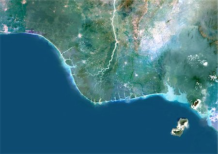
Niger River Delta, Nigeria, True Colour Satellite Image. True colour satellite image of the Niger River Delta in Nigeria, Africa. The city of Lagos, the second most populous city in Africa, is to be seen west of the Niger River Delta on the Atlantic coast in the Gulf of Guinea.Composite image using LANDSAT 5 data.
Rights-Managed
-

Lake Victoria, Africa, True Colour Satellite Image. True colour satellite image of Lake Victoria, one of the African Great Lakes. Lake Victoria is divided between three countries: Kenya, Uganda and Tanzania. Composite image using LANDSAT 5 data.
Rights-Managed
-

Lake Volta, Ghana, True Colour Satellite Image. True colour satellite image of Lake Volta, in Ghana. It is the largest reservoir by surface area in the world, and the fourth largest by volume. Composite image using LANDSAT 7 data.
Rights-Managed
-
Lake Bangweulu, Zambia, True Colour Satellite Image. True colour satellite image of Lake Bangweulu situated in the upper Congo River basin in Zambia, Africa. Part of the Bangweulu Swamps are at the bottom right corner of the image. Composite image from May 2002 using LANDSAT 7 data.
Rights-Managed
-

Lake Tanganyika, Africa, True Colour Satellite Image. True colour satellite image of Lake Tanganyika, an African Great Lake divided between four countries : Burundi, Democratic Republic of the Congo (DRC), Tanzania and Zambia. Composite image using LANDSAT 5 data.
Rights-Managed
-
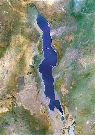
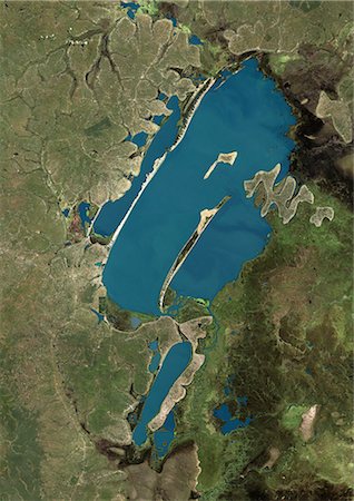
Lake Malawi, Africa, True Colour Satellite Image. True colour satellite image of Lake Malawi, an African Great Lake situated between Malawi, Mozambique, and Tanzania. Composite image using LANDSAT 5 data.
Rights-Managed
-

Kerkennah Islands, Tunisia, True Colour Satellite Image. True colour satellite image of Kerkennah Islands, a group of islands lying off the East coast of Tunisia in the Gulf of Gabes. Image taken on 21 March 2001 using LANDSAT 7 data.
Rights-Managed
-
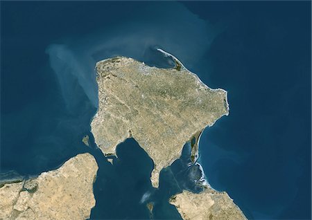
Djerba, Tunisia, True Colour Satellite Image. True colour satellite image of Djerba, an island located in the Gulf of Gabes off the coast of Tunisia. At the bottom of the image is Tunisia mainlain. Image taken on 13 December 1999 using LANDSAT 7 data.
Rights-Managed
-

Zimbabwe, Africa, True Colour Satellite Image With Mask. Satellite view of Zimbabwe (with mask). This image was compiled from data acquired by LANDSAT 5 & 7 satellites.
Rights-Managed
-

Zambia, Africa, True Colour Satellite Image With Mask. Satellite view of Zambia (with mask). This image was compiled from data acquired by LANDSAT 5 & 7 satellites.
Rights-Managed
-

Togo, Africa, True Colour Satellite Image With Mask. Satellite view of Togo (with mask). This image was compiled from data acquired by LANDSAT 5 & 7 satellites.
Rights-Managed
-

Chad, Africa, True Colour Satellite Image With Mask. Satellite view of Chad (with mask). This image was compiled from data acquired by LANDSAT 5 & 7 satellites.
Rights-Managed
-

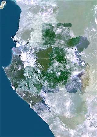
Tanzania, Africa, True Colour Satellite Image With Mask. Satellite view of Tanzania (with mask). This image was compiled from data acquired by LANDSAT 5 & 7 satellites.
Rights-Managed
-

Swaziland, Africa, True Colour Satellite Image With Mask. Satellite view of Zwaziland (with mask). This image was compiled from data acquired by LANDSAT 5 & 7 satellites.
Rights-Managed
-

Sudan, Africa, True Colour Satellite Image With Mask. Satellite view of Sudan (with mask). This image was compiled from data acquired by LANDSAT 5 & 7 satellites.
Rights-Managed
-
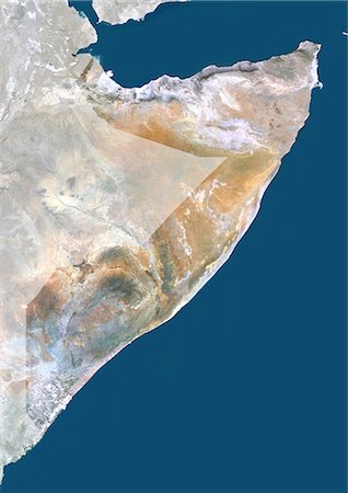
Somalia, Africa, True Colour Satellite Image With Mask. Satellite view of Somalia (with mask). This image was compiled from data acquired by LANDSAT 5 & 7 satellites.
Rights-Managed
-

Sierra Leone, Africa, True Colour Satellite Image With Mask. Satellite view of Sierra Leone (with mask). This image was compiled from data acquired by LANDSAT 5 & 7 satellites.
Rights-Managed
-

Senegal, Africa, True Colour Satellite Image With Mask. Satellite view of Senegal (with mask). This image was compiled from data acquired by LANDSAT 5 & 7 satellites.
Rights-Managed
-

Western Sahara, Africa, True Colour Satellite Image With Mask. Satellite view of Western Sahara (with mask). This image was compiled from data acquired by LANDSAT 5 & 7 satellites.
Rights-Managed
-
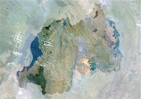
Rwanda, Africa, True Colour Satellite Image With Mask. Satellite view of Rwanda (with mask). This image was compiled from data acquired by LANDSAT 5 & 7 satellites.
Rights-Managed
-

Democratic Republic Of The Congo, Africa, True Colour Satellite Image With Mask. Satellite view of the Democratic Republic of the Congo - Kinshasa (with mask). This image was compiled from data acquired by LANDSAT 5 & 7 satellites.
Rights-Managed
-

Central African Republic, Africa, True Colour Satellite Image With Mask. Satellite view of Central African Republic (with mask). This image was compiled from data acquired by LANDSAT 5 & 7 satellites.
Rights-Managed
-
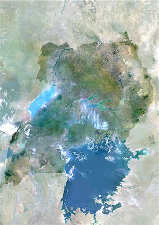
Uganda, Africa, True Colour Satellite Image With Mask. Satellite view of Uganda (with mask). This image was compiled from data acquired by LANDSAT 5 & 7 satellites.
Rights-Managed
-
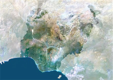
Nigeria, Africa, True Colour Satellite Image With Mask. Satellite view of Nigeria (with mask). This image was compiled from data acquired by LANDSAT 5 & 7 satellites.
Rights-Managed
-

Niger, Africa, True Colour Satellite Image With Mask. Satellite view of Niger (with mask). This image was compiled from data acquired by LANDSAT 5 & 7 satellites.
Rights-Managed
-

Namibia, Africa, True Colour Satellite Image With Mask. Satellite view of Namibia (with mask). This image was compiled from data acquired by LANDSAT 5 & 7 satellites.
Rights-Managed
-
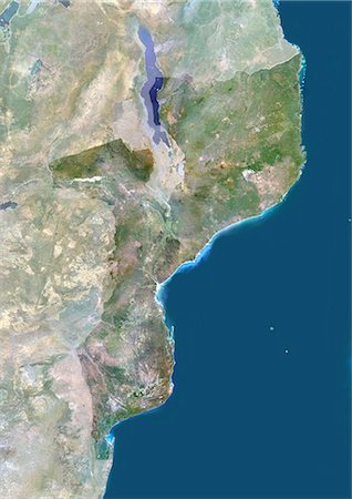
Mozambique, Africa, True Colour Satellite Image With Mask. Satellite view of Mozambique (with mask). This image was compiled from data acquired by LANDSAT 5 & 7 satellites.
Rights-Managed
-

Mauritania, Africa, True Colour Satellite Image With Mask. Satellite view of Mauritania (with border and mask). This image was compiled from data acquired by LANDSAT 5 & 7 satellites.
Rights-Managed
-
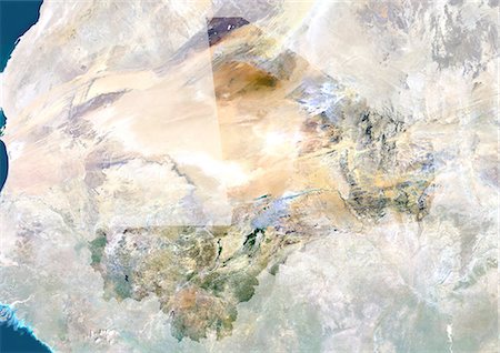
Mali, Africa, True Colour Satellite Image With Mask. Satellite view of Mali (with mask). This image was compiled from data acquired by LANDSAT 5 & 7 satellites.
Rights-Managed
-

Malawi, Africa, True Colour Satellite Image With Mask. Satellite view of Malawi (with mask). This image was compiled from data acquired by LANDSAT 5 & 7 satellites.
Rights-Managed
-

Libya, Africa, True Colour Satellite Image With Mask. Satellite view of Libya (with mask). This image was compiled from data acquired by LANDSAT 5 & 7 satellites.
Rights-Managed
-
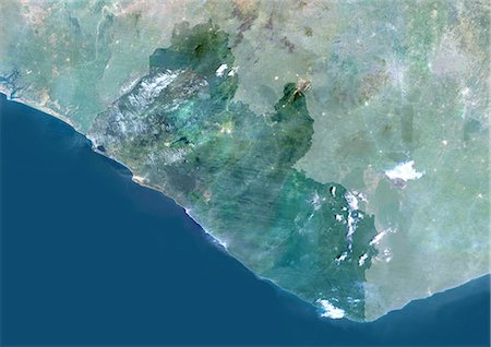
Liberia, Africa, True Colour Satellite Image With Mask. Satellite view of Liberia (with mask). This image was compiled from data acquired by LANDSAT 5 & 7 satellites.
Rights-Managed
-

Lesotho, Africa, True Colour Satellite Image With Mask. Satellite view of Lesotho (with mask). This image was compiled from data acquired by LANDSAT 5 & 7 satellites.
Rights-Managed
-
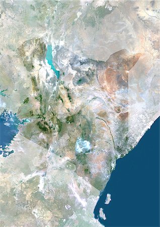
Kenya, Africa, True Colour Satellite Image With Mask. Satellite view of Kenya (with mask). This image was compiled from data acquired by LANDSAT 5 & 7 satellites.
Rights-Managed
-

Guinea Bissau, Africa, True Colour Satellite Image With Mask. Satellite view of Guinea Bissau (with mask). This image was compiled from data acquired by LANDSAT 5 & 7 satellites.
Rights-Managed
-

Guinea, Africa, True Colour Satellite Image With Mask. Satellite view of Guinea (with mask). This image was compiled from data acquired by LANDSAT 5 & 7 satellites.
Rights-Managed
-

Ghana, Africa, True Colour Satellite Image With Mask. Satellite view of Ghana (with mask). This image was compiled from data acquired by LANDSAT 5 & 7 satellites.
Rights-Managed
-

Gambia, Africa, True Colour Satellite Image With Mask. Satellite view of Gambia (with mask). This image was compiled from data acquired by LANDSAT 5 & 7 satellites.
Rights-Managed
-
Gabon, Africa, True Colour Satellite Image With Mask. Satellite view of Gabon (with mask). This image was compiled from data acquired by LANDSAT 5 & 7 satellites.
Rights-Managed
-

Ethiopia, Africa, True Colour Satellite Image With Mask. Satellite view of Ethiopia (with mask). This image was compiled from data acquired by LANDSAT 5 & 7 satellites.
Rights-Managed
-

Eritrea, Africa, True Colour Satellite Image With Mask. Satellite view of Eritrea (with mask). This image was compiled from data acquired by LANDSAT 5 & 7 satellites.
Rights-Managed
-

Djibouti, Africa, True Colour Satellite Image With Mask. Satellite view of Djibouti (with mask). This image was compiled from data acquired by LANDSAT 5 & 7 satellites.
Rights-Managed


