-

Weddell Sea, Antarctica, True Colour Satellite Image. Weddel Sea, Antarctica, true colour satellite image. Pack ice melting in spring time in the Weddel Sea, East of the Antarctica peninsula. Image taken on 21 February 2000 using LANDSAT data.
Rights-Managed
-

Pack Ice In Siberia, Russia, True Colour Satellite Image. True colour satellite image of pack ice in Northern Russia, South of the New Siberia Archipelago. The picture shows how the pack ice that is 1 to 2m thick partly melts in summer time. Image taken on 30 July 2000 using LANDSAT data.
Rights-Managed
-

Pine Island Bay, Amundsen Sea, Antarctica, True Colour Satellite Image. True colour satellite of Pine Island Bay in the Amundsen Sea.The blakek mark crossing the image shows the limit between the indlansis of the Wallgreen coast and Pine Island Bay in Amundsen Sea, in the Western part of Antarctica. Image taken on 13 January 2001 using LANDSAT data.
Rights-Managed
-
Kerguelen Islands, Southern Indian Ocean, True Colour Satellite Image. True colour satellite image of the Kerguelen Islands (France), a group of islands in the southern Indian Ocean that is part of the French Southern and Antarctic Lands.The main island is called Grande Terre. Image using LANDSAT 7 data.
Rights-Managed
-

-
-
-

-

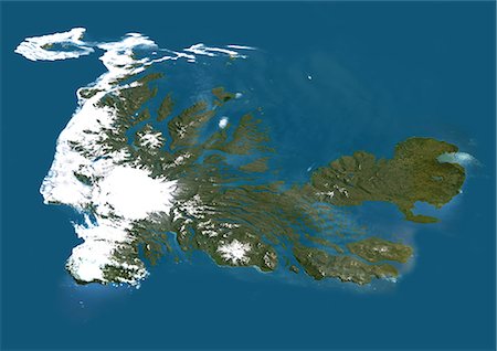
Satellite view of the Kerguelen Islands, a group of islands in the southern Indian Ocean that is part of the French Southern and Antarctic Lands. The main island is called Grande Terre. This image was compiled from data acquired by Landsat satellites.
Rights-Managed
-
-

-
-
United States (Alaska Incl.), True Colour Satellite Image With Border And Mask. USA (Alaska incl.), true colour satellite image with border and mask. This image was compiled from data acquired by LANDSAT 5 & 7 satellites.
Rights-Managed
-

United States (Alaska Incl.), True Colour Satellite Image With Border. USA (Alaska incl.) and Canada, true colour satellite image. This image was compiled from data acquired by LANDSAT 5 & 7 satellites.
Rights-Managed
-

United States (Alaska Incl.), True Colour Satellite Image With Mask. USA (Alaska incl.), true colour satellite image with mask. This image was compiled from data acquired by LANDSAT 5 & 7 satellites.
Rights-Managed
-

Mackenzie River Delta, Canada, True Colour Satellite Image. True colour satellite image of the Mackenzie River Delta. The Mackenzie River originates in Great Slave Lake, in the Northwest Territories (Canada), and flows north into the Arctic Ocean. Composite image using LANDSAT 7 data.
Rights-Managed
-
Great Bear Lake, Canada, True Colour Satellite Image. True colour satellite image of Great Bear Lake, in the Northwest Territories of Canada. This lake, which is the largest lake entirely within Canada, is situated on the Arctic Circle. It is covered with ice from late November to July. Composite image using LANDSAT 5 data.
Rights-Managed
-

Greenland, True Colour Satellite Image With Mask. Satellite view of Greenland (with mask). This image was compiled from data acquired by LANDSAT 5 & 7 satellites.
Rights-Managed
-
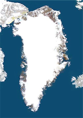
Greenland, True Colour Satellite Image With Border And Mask. Satellite view of Greenland (with border and mask). This image was compiled from data acquired by LANDSAT 5 & 7 satellites.
Rights-Managed
-
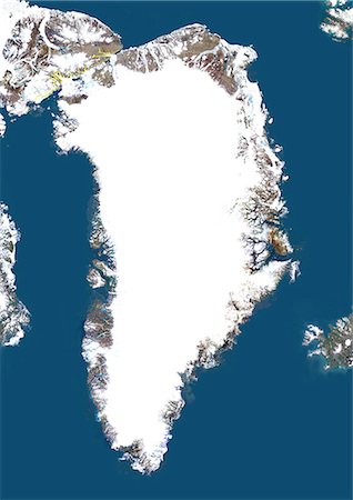
Greenland, True Colour Satellite Image With Border. Satellite view of Greenland (with border). This image was compiled from data acquired by LANDSAT 5 & 7 satellites.
Rights-Managed
-
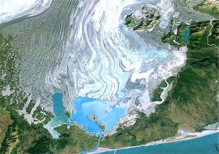
Bering Glacier, Alaska, Usa, True Colour Satellite Image. Satellite image of the Bering Glacier, the largest glacier in North America. It currently terminates in Vitus Lake (South East on the picture), about 10km from the Gulf of Alaska, and flows into the sea through a small outlet. The glacier is bordered by gray moraines. Image taken on 25 September 1986 using LANDSAT data.
Rights-Managed
-
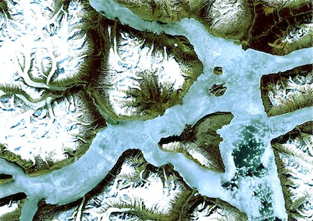
King Oscar Fjord, Greenland, True Colour Satellite Image. King Oscar Fjord located in Greenland National Park. The pastel blue indicates that the water has turned into ice. Image taken on 21 June 1991 using LANDSAT data.
Rights-Managed
-
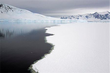
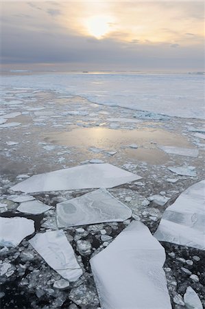
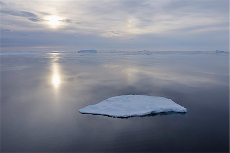
View from above, of melting sea ice off the shores of islands in Antarctica.
Premium Royalty-Free
-
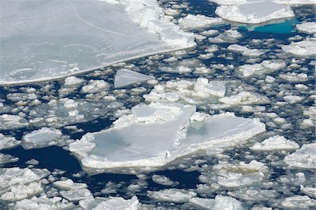
View from above, of melting sea ice off the shores of islands in Antarctica.
Premium Royalty-Free
-
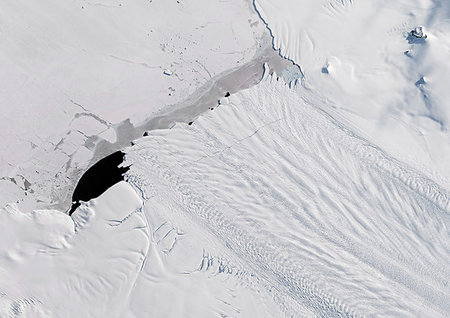
Color satellite image of Pine Island Glacier, Antarctica on September 21, 2017.
Rights-Managed
-

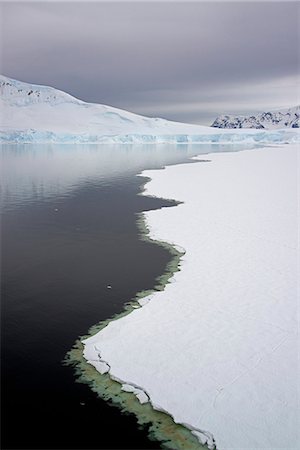
Pack ice and iceberg, Antarctic Peninsula, Weddell Sea, Antarctica, Polar Regions
Rights-Managed
-
-
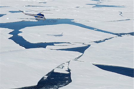
Helicopter Flying over Pack Ice, Weddell Sea, Antarctic Peninsula, Antarctica
Rights-Managed
-

-
-

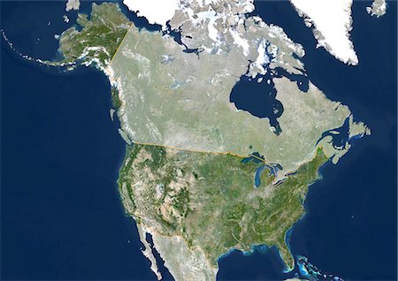
Satellite view of North America in winter, with partial snow cover. This image was compiled from data acquired by Landsat 7 & 8 satellites.
Rights-Managed
-
Satellite view of North America that shows Arctic ice cap. This image was compiled from data acquired by Landsat 7 & 8 satellites.
Rights-Managed
-

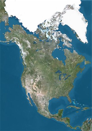
Satellite view of North America. This image was compiled from data acquired by Landsat 7 & 8 satellites.
Rights-Managed
-

Satellite view of the State of Alaska, United States. This image was compiled from data acquired by LANDSAT 5 & 7 satellites.
Rights-Managed
-
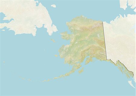
Relief map of the State of Alaska, United States. This image was compiled from data acquired by LANDSAT 5 & 7 satellites combined with elevation data.
Rights-Managed
-

Relief map of the State of Alaska, United States. This image was compiled from data acquired by LANDSAT 5 & 7 satellites combined with elevation data.
Rights-Managed
-

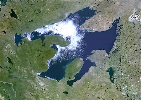
Satellite view of Nunavut, Canada. This image was compiled from data acquired by LANDSAT 5 & 7 satellites.
Rights-Managed
-

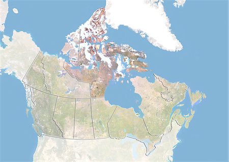
Relief map of Nunavut, Canada. This image was compiled from data acquired by LANDSAT 5 & 7 satellites combined with elevation data.
Rights-Managed
-
Relief map of Nunavut, Canada. This image was compiled from data acquired by LANDSAT 5 & 7 satellites combined with elevation data.
Rights-Managed
-

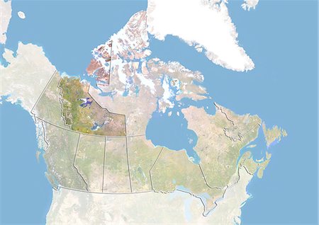
Satellite view of the Northwest Territories, Canada. This image was compiled from data acquired by LANDSAT 5 & 7 satellites.
Rights-Managed
-

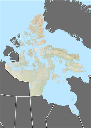
Relief map of the Northwest Territories, Canada. This image was compiled from data acquired by LANDSAT 5 & 7 satellites combined with elevation data.
Rights-Managed
-

Relief map of the Northwest Territories, Canada. This image was compiled from data acquired by LANDSAT 5 & 7 satellites combined with elevation data.
Rights-Managed
-

-

-

-

-

-

-
-

-

-
-

-
-

-

-

-
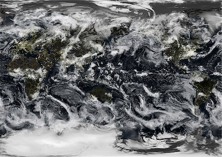
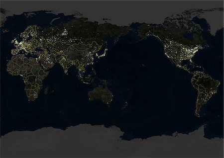
Whole Earth At Night Centred On Pacific Ocean, True Colour Satellite Image. True colour satellite image of the whole Earth at night, centred on the Pacific Ocean, with country borders and cloud coverage. This image in Miller projection was compiled from data acquired by LANDSAT 5 & 7 satellites.
Rights-Managed
-
Whole Earth At Night Centred On Pacific Ocean, True Colour Satellite Image. True colour satellite image of the whole Earth at night, centred on the Pacific Ocean, with country borders. This image in Miller projection was compiled from data acquired by LANDSAT 5 & 7 satellites.
Rights-Managed
-

Whole Earth At Night Centred On Pacific Ocean, True Colour Satellite Image. True colour satellite image of the whole Earth at night, centred on the Pacific Ocean, with cloud coverage. This image in Miller projection was compiled from data acquired by LANDSAT 5 & 7 satellites.
Rights-Managed
-

Whole Earth At Night Centred On Pacific Ocean, True Colour Satellite Image. True colour satellite image of the whole Earth at night, centred on the Pacific Ocean. This image in Miller projection was compiled from data acquired by LANDSAT 5 & 7 satellites.
Rights-Managed
-

Whole Earth Centred On Pacific Ocean, True Colour Satellite Image. True colour satellite image of the whole Earth centred on the Pacific Ocean, with country borders and major rivers. This image in Miller projection was compiled from data acquired by LANDSAT 5 & 7 satellites.
Rights-Managed
-
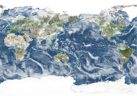
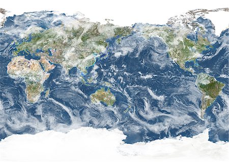
Whole Earth Centred On Pacific Ocean, True Colour Satellite Image. True colour satellite image of the whole Earth centred on the Pacific Ocean, with country borders and cloud coverage. This image in Miller projection was compiled from data acquired by LANDSAT 5 & 7 satellites.
Rights-Managed
-
Whole Earth Centred On Pacific Ocean, True Colour Satellite Image. True colour satellite image of the whole Earth centred on the Pacific Ocean, with major rivers. This image in Miller projection was compiled from data acquired by LANDSAT 5 & 7 satellites.
Rights-Managed
-

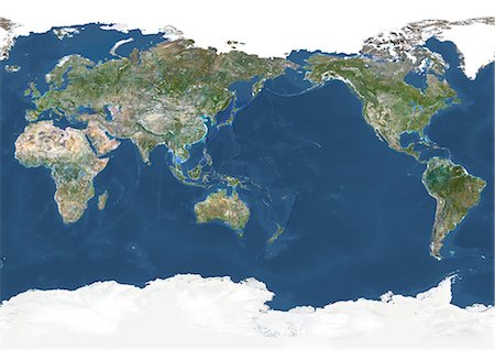
Whole Earth Centred On Pacific Ocean, True Colour Satellite Image. True colour satellite image of the whole Earth centred on the Pacific Ocean, with country borders. This image in Miller projection was compiled from data acquired by LANDSAT 5 & 7 satellites.
Rights-Managed
-
Whole Earth Centred On Pacific Ocean, True Colour Satellite Image. True colour satellite image of the whole Earth centred on the Pacific Ocean, with cloud coverage. This image in Miller projection was compiled from data acquired by LANDSAT 5 & 7 satellites.
Rights-Managed
-

Whole Earth Centred On Pacific Ocean, True Colour Satellite Image. True colour satellite image of the whole Earth centred on the Pacific Ocean. This image in Miller projection was compiled from data acquired by LANDSAT 5 & 7 satellites.
Rights-Managed
-

Whole Earth Centred On Pacific Ocean, True Colour Satellite Image. True colour satellite image of the whole Earth centred on the Pacific Ocean, with bump effect. This image in Miller projection was compiled from data acquired by LANDSAT 5 & 7 satellites.
Rights-Managed
-
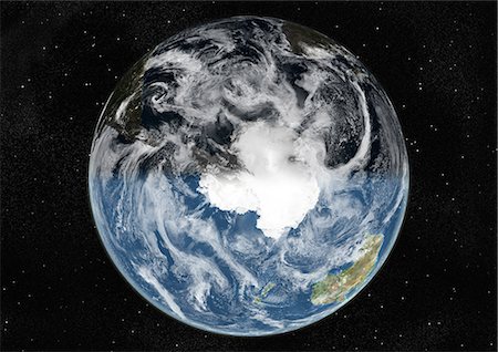
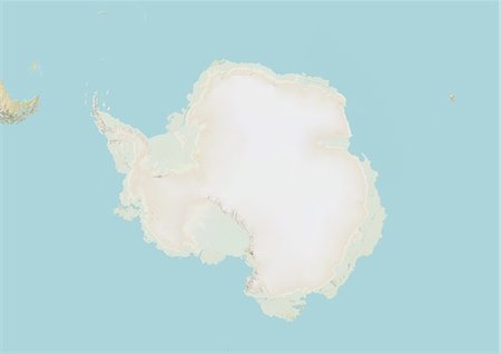
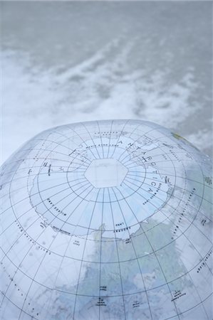
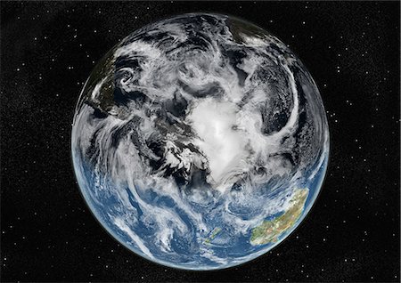
Globe Centred On The South Pole, True Colour Satellite Image. True colour satellite image of the Earth centred on the South Pole with cloud coverage, at the equinox at 12 p.m GMT. This image in orthographic projection was compiled from data acquired by LANDSAT 5 & 7 satellites.
Rights-Managed
-

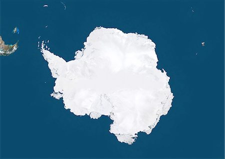
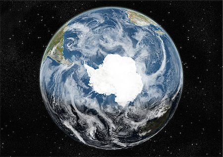
Globe Centred On The South Pole, True Colour Satellite Image. True colour satellite image of the Earth centred on the South Pole, at the equinox at 12 p.m GMT. This image in orthographic projection was compiled from data acquired by LANDSAT 5 & 7 satellites.
Rights-Managed
-

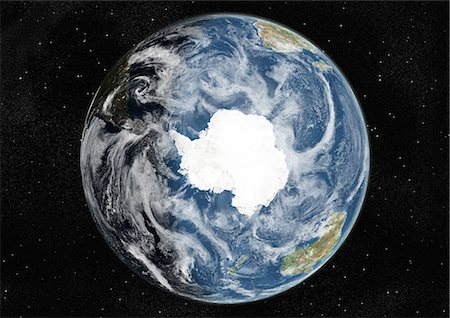
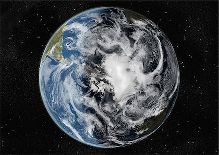
Globe Centred On The South Pole, True Colour Satellite Image. True colour satellite image of the Earth centred on the South Pole with cloud coverage, at the equinox at 6 p.m GMT. This image in orthographic projection was compiled from data acquired by LANDSAT 5 & 7 satellites.
Rights-Managed
-

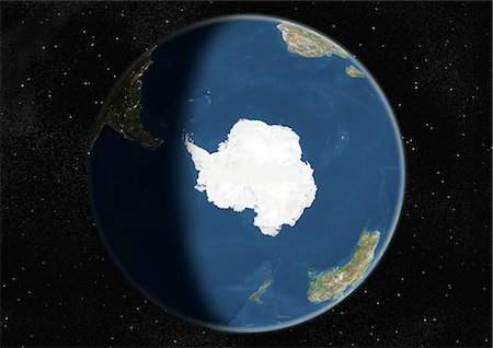
Globe Centred On The South Pole, True Colour Satellite Image. True colour satellite image of the Earth centred on the South Pole, at the equinox at 6 p.m GMT. This image in orthographic projection was compiled from data acquired by LANDSAT 5 & 7 satellites.
Rights-Managed
-

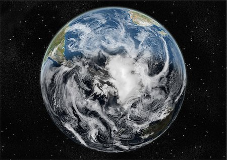
Globe Centred On The South Pole, True Colour Satellite Image. True colour satellite image of the Earth centred on the South Pole with cloud coverage, at the equinox at 12 a.m GMT. This image in orthographic projection was compiled from data acquired by LANDSAT 5 & 7 satellites.
Rights-Managed
-

Globe Centred On The South Pole, True Colour Satellite Image. True colour satellite image of the Earth centred on the South Pole, at the equinox at 12 a.m GMT. This image in orthographic projection was compiled from data acquired by LANDSAT 5 & 7 satellites.
Rights-Managed
-

Globe Centred On The South Pole, True Colour Satellite Image. True colour satellite image of the Earth centred on the South Pole with cloud coverage, at the equinox at 6 a.m GMT. This image in orthographic projection was compiled from data acquired by LANDSAT 5 & 7 satellites.
Rights-Managed
-

Globe Centred On The South Pole, True Colour Satellite Image. True colour satellite image of the Earth centred on the South Pole, at the equinox at 6 a.m GMT. This image in orthographic projection was compiled from data acquired by LANDSAT 5 & 7 satellites.
Rights-Managed
-

Globe Centred On The South Pole, True Colour Satellite Image. True colour satellite image of the Earth centred on the South Pole with cloud coverage, during winter solstice at 12 p.m GMT. This image in orthographic projection was compiled from data acquired by LANDSAT 5 & 7 satellites.
Rights-Managed
-

Globe Centred On The South Pole, True Colour Satellite Image. True colour satellite image of the Earth centred on the South Pole, during winter solstice at 12 p.m GMT. This image in orthographic projection was compiled from data acquired by LANDSAT 5 & 7 satellites.
Rights-Managed
-

Globe Centred On The South Pole, True Colour Satellite Image. True colour satellite image of the Earth centred on the South Pole with cloud coverage, during winter solstice at 6 p.m GMT. This image in orthographic projection was compiled from data acquired by LANDSAT 5 & 7 satellites.
Rights-Managed
-

Globe Centred On The South Pole, True Colour Satellite Image. True colour satellite image of the Earth centred on the South Pole, during winter solstice at 6 p.m GMT. This image in orthographic projection was compiled from data acquired by LANDSAT 5 & 7 satellites.
Rights-Managed
-
Globe Centred On The South Pole, True Colour Satellite Image. True colour satellite image of the Earth centred on the South Pole with cloud coverage, during winter solstice at 12 a.m GMT. This image in orthographic projection was compiled from data acquired by LANDSAT 5 & 7 satellites.
Rights-Managed
-

Globe Centred On The South Pole, True Colour Satellite Image. True colour satellite image of the Earth centred on the South Pole, during winter solstice at 12 a.m GMT. This image in orthographic projection was compiled from data acquired by LANDSAT 5 & 7 satellites.
Rights-Managed
-
Globe Centred On The South Pole, True Colour Satellite Image. True colour satellite image of the Earth centred on the South Pole with cloud coverage, during winter solstice at 6 a.m GMT. This image in orthographic projection was compiled from data acquired by LANDSAT 5 & 7 satellites.
Rights-Managed
-
Globe Centred On The South Pole, True Colour Satellite Image. True colour satellite image of the Earth centred on the South Pole, during winter solstice at 6 a.m GMT. This image in orthographic projection was compiled from data acquired by LANDSAT 5 & 7 satellites.
Rights-Managed
-
Globe Centred On The South Pole, True Colour Satellite Image. True colour satellite image of the Earth centred on the South Pole with cloud coverage, during summer solstice at 12 p.m GMT. This image in orthographic projection was compiled from data acquired by LANDSAT 5 & 7 satellites.
Rights-Managed
-

Globe Centred On The South Pole, True Colour Satellite Image. True colour satellite image of the Earth centred on the South Pole, during summer solstice at 12 p.m GMT. This image in orthographic projection was compiled from data acquired by LANDSAT 5 & 7 satellites.
Rights-Managed
-
Globe Centred On The South Pole, True Colour Satellite Image. True colour satellite image of the Earth centred on the South Pole with cloud coverage, during summer solstice at 6 p.m GMT. This image in orthographic projection was compiled from data acquired by LANDSAT 5 & 7 satellites.
Rights-Managed
-

Globe Centred On The South Pole, True Colour Satellite Image. True colour satellite image of the Earth centred on the South Pole, during summer solstice at 6 p.m GMT. This image in orthographic projection was compiled from data acquired by LANDSAT 5 & 7 satellites.
Rights-Managed
-
Globe Centred On The South Pole, True Colour Satellite Image. True colour satellite image of the Earth centred on the South Pole with cloud coverage, during summer solstice at 12 a.m GMT. This image in orthographic projection was compiled from data acquired by LANDSAT 5 & 7 satellites.
Rights-Managed
-

Globe Centred On The South Pole, True Colour Satellite Image. True colour satellite image of the Earth centred on the South Pole, during summer solstice at 12 a.m GMT. This image in orthographic projection was compiled from data acquired by LANDSAT 5 & 7 satellites.
Rights-Managed


