-

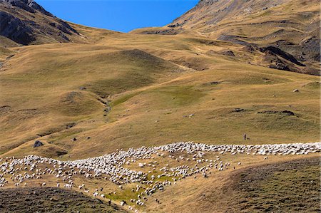
Shepherd with mountain sheep in the Pyrenees National Park, Parc National des Pyrenees Occident, France
Rights-Managed
-
Europe, Spain, Pyrenees, Pico de Aneto (3404m), highest peak in mainland spain, climber looking at sunrise view
Rights-Managed
-

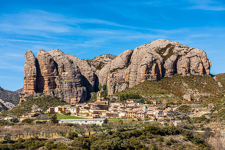
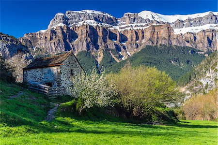
The 2282m Pena Foratata, not the highest but most iconic peak in the upper Tena Valley, Sallent de Gallego, Pyrenees, Huesca, Spain, Europe
Premium Royalty-Free
-

-
-

-

-

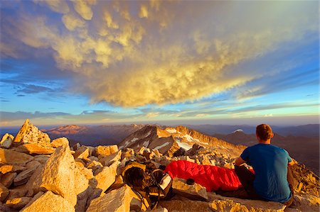
Mountains silhouetted at sunrise, view from Pico de Aneto, at 3404m the highest peak in the Pyrenees, Spain, Europe
Rights-Managed
-
Europe, Spain, Pyrenees, Pico de Aneto (3404m), highest peak in mainland spain, sunrise view from summit
Rights-Managed
-
-
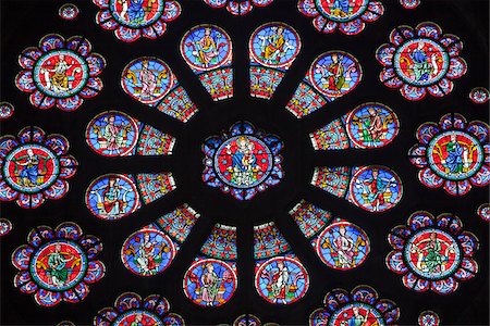
France, Aquitaine, Pau. A stained glass window in the Church of St Martin in Pau, whose architect Boeswillwald was inspired by Notre Dame Cathedral in Paris.
Rights-Managed
-
-
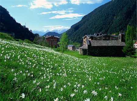
Poet's narcissus (Narcissus poeticus) and tiny old church above Arinsal village where Andorra's national flower grows in profusion, Arinsal, Andorra, Pyrenees, Europe
Rights-Managed
-

-

A man on a very long and overhanging climb on the famous limestone cliffs of the Mascun Canyon, Rodellar, Sierra de Guara, Aragon, southern Pyrenees, Spain, Europe
Rights-Managed
-

View at sunrise, view from Pico de Aneto, at 3404m the highest peak in the Pyrenees, Spain, Europe
Rights-Managed
-

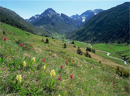
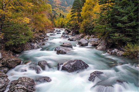
View from Rio Caldares valley head trail down to the Llano Bozuelo pasture, Banos de Panticosa, Pyrenees, Huesca Province, Spain, Europe
Premium Royalty-Free
-

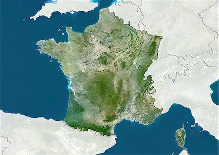
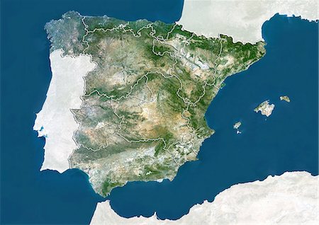
Relief map of Spain (with border and mask). This image was compiled from data acquired by landsat 5 & 7 satellites combined with elevation data.
Rights-Managed
-

Torla, the River Ara and distant Mondarruego, Huesca (Pyrenees), Aragon, Spain, Europe
Rights-Managed
-
-
Wild orchids (Dactyorhiza sambucina), Vall d'Incles, Soldeu, Andorra, Europe
Rights-Managed
-

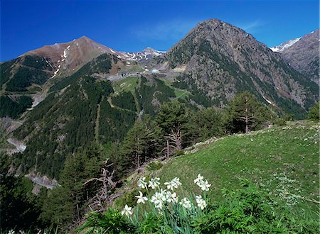
From left, peaks of Corona de Mallo, Parad 2764m and Telera on right, seen from Panticosa, Upper Tena Valley, Pyrenees, Huesca, Spain, Europe
Premium Royalty-Free
-

-
-

-

-
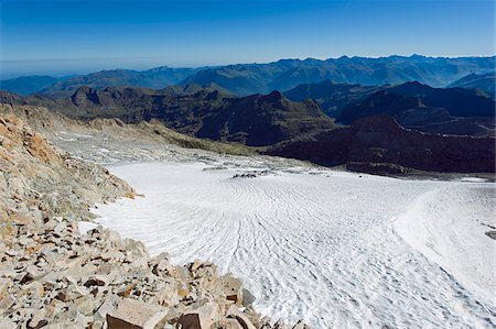
Europe, Spain, Pyrenees, Pico de Aneto (3404m), highest peak in mainland spain, Aneto glacier
Rights-Managed
-
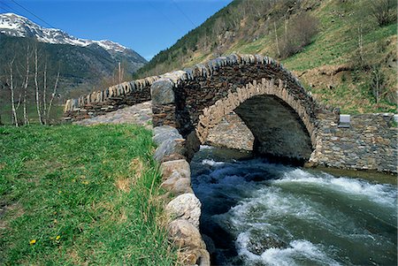
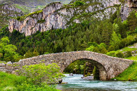
Ancient stone bridge over a river in the La Malana district in the Pyrenees in Andorra, Europe
Rights-Managed
-
-
Poets narcissus (Narcissus poeticus) and view west across the Arinsal valley to the Arinsal ski station in early summer, Arinsal, Percanela, Andorra, Europe
Rights-Managed
-

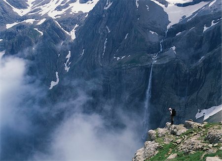
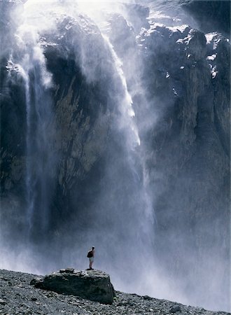
Waterfall in the Ordesa valley, Ordesa National Park, Huesca, Pyrenees, Aragon, Spain, Europe
Rights-Managed
-
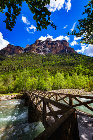
Footbridge crossing river with majestic mountain of the Pyrenees in the background in Ordesa y Monte Perdido National Park in Huesca, Aragon, Spain
Rights-Managed
-

Aydius village, valley of the River Gabarret, Bearn, Aquitaine, Pyrenees, France, Europe
Rights-Managed
-
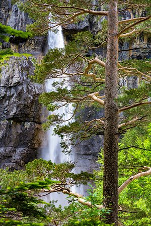
Looking through trees at waterfall in the Ordesa y Monte Perdido National Park in the Pyrenees in Huesca Province in Aragon, Spain
Rights-Managed
-

Pyrenees mountains behind the town of Torla (Torla-Ordesa) in Ordesa y Monte Perdido National Park in Huesca Province in Aragon, Spain
Rights-Managed
-
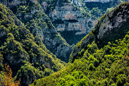
Close-up of forested mountains overlapping in Ordesa y Monte Perdido National Park in the Pyrenees in Huesca Province in Aragon, Spain
Rights-Managed
-

View of the Pyrenees from Superbagneres Ski Resort, Bagneres-de-Luchon in the Occitanie Region, France
Rights-Managed
-

Overview of the forested mountains of the Pyrenees in the Ordesa y Monte Perdido National Park in Huesca Province, Aragon, Spain
Rights-Managed
-
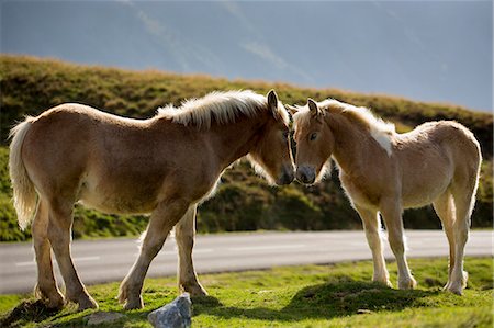
Mare and foal horses in Vallee d'Ossau near Laruns in Parc National des Pyrenees Occident, France
Rights-Managed
-
-
Low cloud in the mountains, National Park in the Pyrenees, Parc National des Pyrenees Occident, France
Rights-Managed
-
Mountain sheep and goats with shepherd in Val de Tena at Formigal in Spanish Pyrenees mountains, Spain, Europe
Rights-Managed
-

Traditional homes and church on hillside in Cires near Bagneres-de-Luchon in Haute-Garonne in Occitanie region in the Pyrenees, France
Rights-Managed
-
Stone footbridge over river in the Ordesa y Monte Perdido National Park in the Pyrenees in Huesca Province in Aragon, Spain
Rights-Managed
-

-

Looking through the tres at sunlit forest on the mountains in the Pyrenees in the Ordesa y Monte Perdido National Park in Huesca Provnce, Aragon, Spain
Rights-Managed
-

Autumn landscape in Ordesa and Monte Perdido National Park, Huesca, Aragon, Spain
Rights-Managed
-

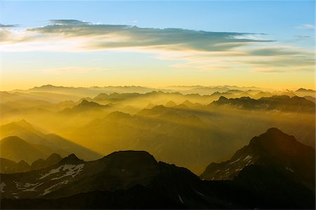
Mist in the valleys at sunrise, seen from the Col de Portel, Pyrenees, France
Rights-Managed
-

-

-
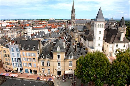
France, Aquitaine, Pyrenees Atlantiques, region of Bearn, Pau. General view from the castle's dunjon, rue du Chateau and the Parliament of Navarre (General Council) in the foreground
Rights-Managed
-
View west along the Ordesa Valley to distant Mondarruego and Otal peaks, Ordesa National Park, Pyrenees, Aragon, Spain, Europe
Premium Royalty-Free
-
-

Relief map of Languedoc-Roussillon, France. This image was compiled from data acquired by LANDSAT 5 & 7 satellites combined with elevation data.
Rights-Managed
-

Horse in Vallee d'Ossau near Laruns in Parc National des Pyrenees Occident, France
Rights-Managed
-

Horse in Vallee d'Ossau near Laruns in Parc National des Pyrenees Occident, France
Rights-Managed
-
Autumn landscape in Ordesa and Monte Perdido National Park, Huesca, Aragon, Spain
Rights-Managed
-
Farm hut near Laruns in French Pyrenees mountains, Pyrenees-Atlantiques in Aquitaine region, France, Europe
Rights-Managed
-

-
Walls of Punta Gallinero and Cotatuero cascade on the Ordesa Valley's northern rim, Ordesa National Park, Pyrenees, Aragon, Spain, Europe
Premium Royalty-Free
-

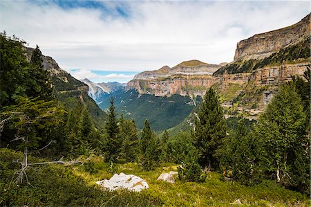
Faja de Pelay trail view of Monte Arruebo and Perdido peak, Ordesa Valley, Ordesa National Park, Pyrenees, Aragon, Spain, Europe
Premium Royalty-Free
-

Satellite view of Midi-Pyrenees, France. This image was compiled from data acquired by LANDSAT 5 & 7 satellites.
Rights-Managed
-
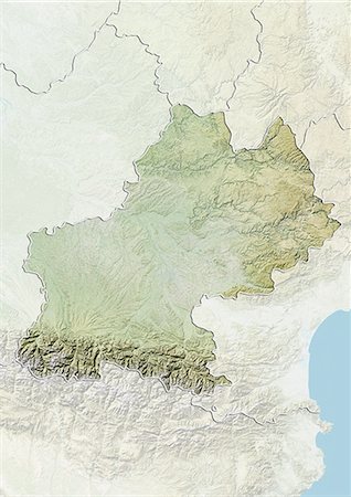
Relief map of Midi-Pyrenees, France. This image was compiled from data acquired by LANDSAT 5 & 7 satellites combined with elevation data.
Rights-Managed
-

Relief map of Navarre, Spain. This image was compiled from data acquired by LANDSAT 5 & 7 satellites combined with elevation data.
Rights-Managed
-
-

-
-

Europe With Cloud Coverage, True Colour Satellite Image. True colour satellite image of Europe with cloud coverage. This image in Lambert Conformal Conic projection was compiled from data acquired by LANDSAT 5 & 7 satellites.
Rights-Managed
-
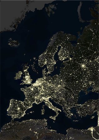
Europe At Night, True Colour Satellite Image. True colour satellite image of Europe at night. This image in Lambert Conformal Conic projection was compiled from data acquired by LANDSAT 5 & 7 satellites.
Rights-Managed
-
View at sunrise from Pico de Aneto, at 3404m the highest peak in the Pyrenees, Spain, Europe
Rights-Managed
-

-

Europe At Night With Country Borders, True Colour Satellite Image. True colour satellite image of Europe at night with country borders. This image in Lambert Conformal Conic projection was compiled from data acquired by LANDSAT 5 & 7 satellites.
Rights-Managed
-
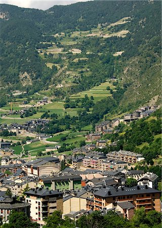
Andorra la Vella, capital city of Andorra state, Andorra, Pyrenees, Europe
Rights-Managed
-

Europe, Spain, Pyrenees, Spain, Lake Corona on the slopes of Pico de Aneto
Rights-Managed
-

-

Europe, Spain, Pyrenees, Pico de Aneto (3404m), highest peak in mainland spain, sunset view
Rights-Managed
-

Rio Aragon Subordan and upper Hecho valley overlooked by karst limestone peaks and woods, Huesca, Aragon, Spain, Europe
Rights-Managed
-

Hiker jumping across a gap in the rocks, Pico de Aneto, the highest peak in the Pyrenees, Spain, Europe
Rights-Managed
-

Europe, True Colour Satellite Image. True colour satellite image of Europe. This image in Lambert Conformal Conic projection was compiled from data acquired by LANDSAT 5 & 7 satellites.
Rights-Managed
-
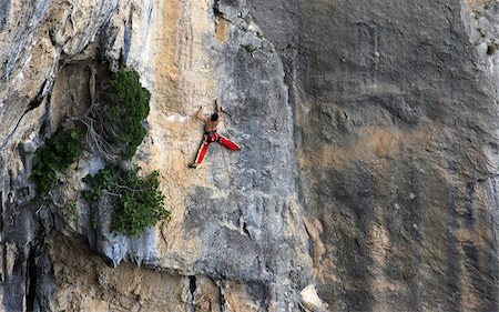
A man on a long and technically demanding face climb on the limestone cliffs of the Mascun Canyon, Rodellar, Sierra de Guara, Aragon, southern Pyrenees, Spain, Europe
Rights-Managed
-

-

Satellite view of Catalonia, Spain. This image was compiled from data acquired by LANDSAT 5 & 7 satellites.
Rights-Managed
-

-

-
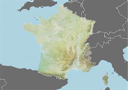
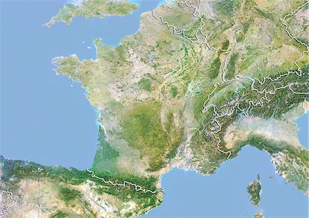
Relief map of France (with border and mask). This image was compiled from data acquired by landsat 5 & 7 satellites combined with elevation data.
Rights-Managed
-

Europe At Night With Cloud Coverage, True Colour Satellite Image. True colour satellite image of Europe at night with cloud coverage. This image in Lambert Conformal Conic projection was compiled from data acquired by LANDSAT 5 & 7 satellites.
Rights-Managed
-

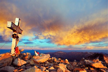
Climbers on summit of Pico de Aneto, at 3404m the highest peak in the Pyrenees, Spain, Europe
Rights-Managed
-

-

A climber walking up a snowfield, Pico de Aneto, the highest peak in the Pyrenees, Spain, Europe
Rights-Managed
-

Relief map of Aragon, Spain. This image was compiled from data acquired by LANDSAT 5 & 7 satellites combined with elevation data.
Rights-Managed


