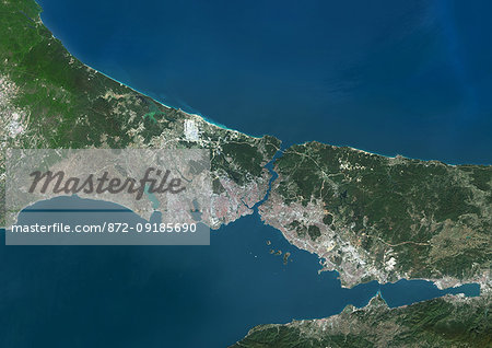
Color satellite image of the Bosphorus Strait, Turkey. The Bosphorus Strait forms part of the continental boundary between Europe (left) and Asia (right) and connects the Black Sea (north) with the Sea of Marmara (south). Istanbul lies at the lower end of the Bosphorus Strait. Image collected on September 20, 2017 by Sentinel-2 satellites.

Einführungsangebot
50% Rabatt, wenn Sie unsere E-Mail-Liste ein
-
Web Resolution
550×389px
19.4×13.8cm 28ppcm
-
Low Resolution
1007×712px
35.6×25.2cm 28ppcm
-
Medium Resolution
2229×1576px
18.9×13.3cm 118ppcm
-
High Resolution
4961×3508px
42.0×29.7cm 118ppcm
* Preis errechnet sich aus der Verwendung, nicht aus der Bildgröße.
Verwandte Bilder
- Color satellite image of the Bosphorus strait, Turkey. Istanbul lies at the lower end of the Bosphorus. Image collected on September 20, 2017 by Sentinel-2 satellites.
- Color satellite image of Istanbul, Turkey. The city lies at the lower end of the Bosphorus Strait. Image collected on September 20, 2017 by Sentinel-2 satellites.
- Colour satellite image of Istanbul, Turkey. Image taken on July 30, 2013 with Landsat 8 data.
- Color satellite image of Ankara, capital city of Turkey. Image collected on October 17, 2017 by Sentinel-2 satellites.
- Color satellite image of Abu Dhabi International Airport, United Arab Emirates. The amusement park Ferrari World Abu Dhabi is on Yas Island, at center left on the image. Image collected on September 21, 2017 by Sentinel-2 satellites.
- Color satellite image of Abu Dhabi, capital city of United Arab Emirates. The city is on an island connected by bridges to the mainland and other islands. Image collected on September 21, 2017 by Sentinel-2 satellites.
- Color satellite image of Doha, capital city of Qatar, with Hamad International Airport to the right. Image collected on October 17, 2017 by Sentinel-2 satellites.
- Color satellite image of Doha, capital city of Qatar. Image collected on October 17, 2017 by Sentinel-2 satellites.
Weitere verwandte Bilder
- Color satellite image of Beirut, capital city of Lebanon, with Beirut-Rafic Hariri International Airport in the south. Image collected on October 18, 2017 by Sentinel-2 satellites.
- Color satellite image of Kuwait City, capital city of Kuwait. Image collected on October 23, 2017 by Sentinel-2 satellites.
- Color satellite image of Manama, capital city of Bahrain. Image collected on October 17, 2017 by Sentinel-2 satellites.
- Color satellite image of Baku, capital city of Azerbaijan. The city is situated on the western coast of the Caspian Sea. Image collected on September 13, 2017 by Sentinel-2 satellites.
- 3D satellite image of Turkey and the Black Sea.
- Colour satellite image of Dubai, United Arab Emirates. Image taken on December 25, 2013 with Landsat 8 data.
- Satellite view of Dubai, United Arab Emirates in 2000, 2005 and 2010. This before and after image shows urban expansion over the years and the construction of the World Islands and the Palm island called Palm Jumeirah.
- Colour satellite image of Abu Dhabi, United Arab Emirates. Image taken on December 16, 2013 with Landsat 8 data.


