-
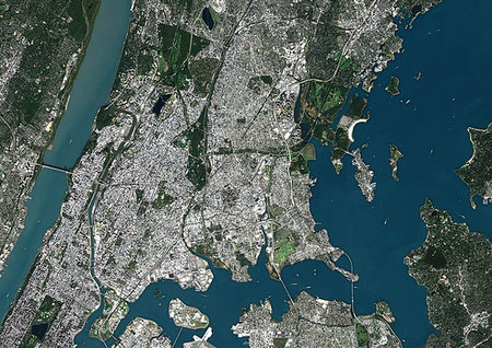
Color satellite image of the Bronx, New York City, New York State, United States. The Bronx is one borough of New York City. It lies north and east of Manhattan, across the Harlem River. Image collected on October 20, 2017 by Sentinel-2 satellites.
Rights-Managed
-

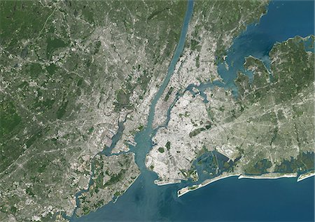
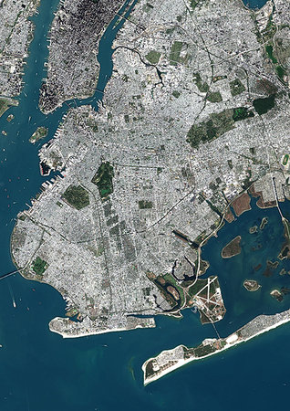
Color satellite image of New York City, New York State, United States. Image collected on October 20, 2017 by Sentinel-2 satellites.
Rights-Managed
-
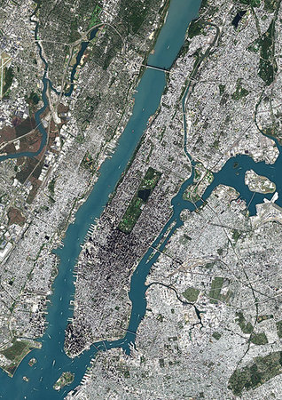
Color satellite image of Manhattan, New York City, New York State, United States. Manhattan is one borough of New York City. It is bound by Hudson River to the west, Harlem River to the north, and East River to the east. Central Park is in the center. Image collected on October 20, 2017 by Sentinel-2 satellites.
Rights-Managed
-
Colour satellite image of New York City, New York State, USA. Image taken on July 31, 2014 with Landsat 8 data.
Rights-Managed
-

Color satellite image of East Coast from Massachusetts to Virginia, United States. Image collected on May 1, 2017 by Sentinel-2 satellites.
Rights-Managed
-

Color satellite image of the East Coast from Massachusetts to Northern Carolina, United States. Image collected on May 1, 2017 by Sentinel-2 satellites.
Rights-Managed
-

Color satellite image of Boston to Washington D.C. on the East Coast of the United States. This region is also called Northeast megalopolis or Boston-Washington corridor. Image collected on May 1, 2017 by Sentinel-2 satellites.
Rights-Managed
-

Color satellite image of New York City to Washington D.C. on the East Coast of the United States. Image collected on May 1, 2017 by Sentinel-2 satellites.
Rights-Managed
-
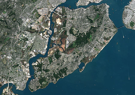
Color satellite image of Staten Island, New York City, New York State, United States. Staten Island is one borough of New York City. It is separated from the rest of New York by New York Bay. Image collected on October 20, 2017 by Sentinel-2 satellites.
Rights-Managed
-
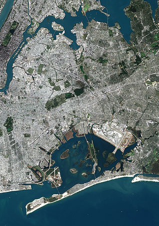
Color satellite image of Queens, New York City, New York State, United States. Located on Long Island, Queens is one borough of New York City. JFK International Airport is at south while la Guardia Airport lies at north. Image collected on October 20, 2017 by Sentinel-2 satellites.
Rights-Managed
-
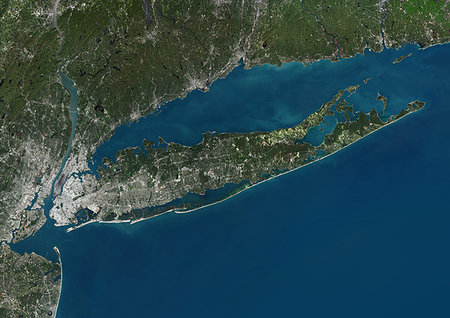
Color satellite image of Long Island, New York State, United States. Image collected on October 20, 2017 by Sentinel-2 satellites.
Rights-Managed
-

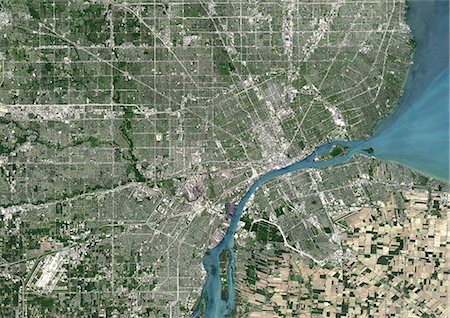
Color satellite image of Detroit, Michigan, United States. Image collected on May 15, 2017 by Sentinel-2 satellites.
Rights-Managed
-

Color satellite image of Detroit, Michigan, United States. Image collected on May 15, 2017 by Sentinel-2 satellites.
Rights-Managed
-

Colour satellite image of New Orleans, Louisiana, USA. Image taken on November 3, 2014 with Landsat 8 data.
Rights-Managed
-
Colour satellite image of Detroit, Michigan, USA. Image taken on June 14, 2014 with Landsat 8 data.
Rights-Managed
-

Colour satellite image of Detroit, Michigan, USA. Image taken on June 14, 2014 with Landsat 8 data.
Rights-Managed
-

Color satellite image of Montevideo, capital city of Uruguay. Image collected on December 12, 2016 by Sentinel-2 satellites.
Rights-Managed
-

Color satellite image of Perth, Australia. Image collected on August 25, 2017 by Sentinel-2 satellites.
Rights-Managed
-

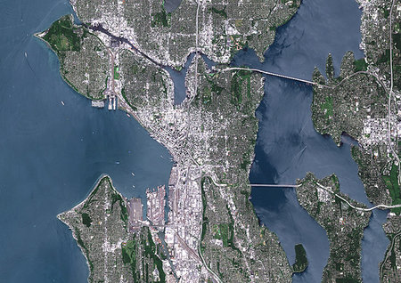
Color satellite image of Seattle, Washington, United States. It is a seaport city located between the Puget Sound to the west and Lake Washington to the east. Image collected on August 31, 2017 by Sentinel-2 satellites.
Rights-Managed
-
Color satellite image of Seattle, Washington, United States. It is a seaport city located between the Puget Sound to the west and Lake Washington to the east. Image collected on August 31, 2017 by Sentinel-2 satellites.
Rights-Managed
-

Color satellite image of the Silicon Valley, California, United States. Image collected on September 27, 2017 by Sentinel-2 satellites.
Rights-Managed
-
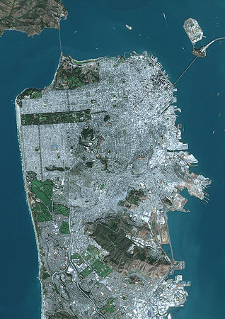
Color satellite image of San Francisco, California, United States. Image collected on September 27, 2017 by Sentinel-2 satellites.
Rights-Managed
-
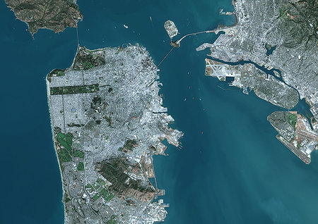
Color satellite image of San Francisco, California, United States. The Bay Bridge connects San Francisco with Oakland at east. Image collected on September 27, 2017 by Sentinel-2 satellites.
Rights-Managed
-
Color satellite image of the Silicon Valley, from San Francisco to San Jose, California, United States. Image collected on September 27, 2017 by Sentinel-2 satellites.
Rights-Managed
-

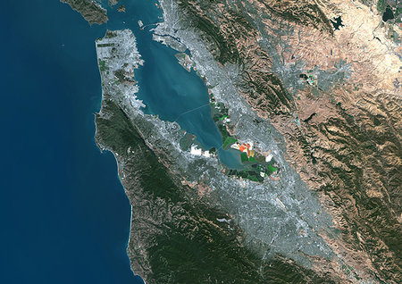
Color satellite image of San Francisco Bay Area, California, United States. Image collected on September 27, 2017 by Sentinel-2 satellites.
Rights-Managed
-

Color satellite image of San Diego, California, United States. The city lies on the coast of the Pacific Ocean in Southern California. Image collected on June 13, 2017 by Sentinel-2 satellites.
Rights-Managed
-

Color satellite image of San Diego, California, United States. The city lies on the coast of the Pacific Ocean in Southern California. Image collected on June 13, 2017 by Sentinel-2 satellites.
Rights-Managed
-

Color satellite image of Portland, Oregon, United States. The city lies at the confluence of the Willamette and Columbia Rivers. Image collected on August 31, 2017 by Sentinel-2 satellites.
Rights-Managed
-

Color satellite image of Portland, Oregon, United States. The city lies at the confluence of the Willamette and Columbia Rivers. Image collected on August 31, 2017 by Sentinel-2 satellites.
Rights-Managed
-
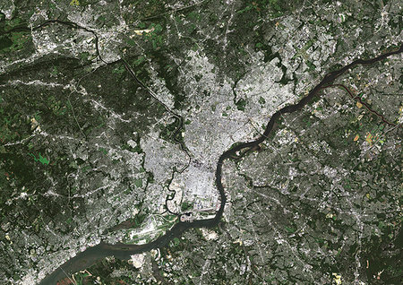
Color satellite image of Philadelphia, Pennsylvania, United States The city is located along the Delaware and Schuylkill Rivers. Image collected on September 23, 2017 by Sentinel-2 satellites.
Rights-Managed
-
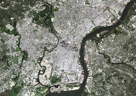
Color satellite image of Philadelphia, Pennsylvania, United States The city is located along the Delaware and Schuylkill Rivers. Image collected on September 23, 2017 by Sentinel-2 satellites.
Rights-Managed
-
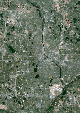
Color satellite image of Minneapolis, Minnesota, United States. The Mississippi River flows through the city. Minneapolis-Saint Paul International Airport is at south. Image collected on November 18, 2017 by Sentinel-2 satellites.
Rights-Managed
-

Color satellite image of Minneapolis, Minnesota, United States. The Mississippi River flows through the city. Image collected on November 18, 2017 by Sentinel-2 satellites.
Rights-Managed
-
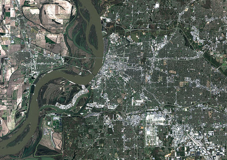
Color satellite image of Memphis, Tennessee, United States. Image collected on March 22, 2018 by Sentinel-2 satellites.
Rights-Managed
-
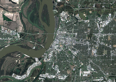
Color satellite image of Memphis, Tennessee, United States. Image collected on March 22, 2018 by Sentinel-2 satellites.
Rights-Managed
-

Color satellite image of Great Portland, Oregon, United States. Image collected on August 31, 2017 by Sentinel-2 satellites.
Rights-Managed
-

Color satellite image of Cape Canaveral, Florida, United States. Cape Canaveral Air Force Station is north of Port Canaveral at center. Image collected on January 24, 2018 by Sentinel-2 satellites.
Rights-Managed
-
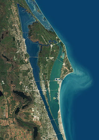
Color satellite image of Cape Canaveral, Florida, United States. Cape Canaveral Air Force Station is southeast of NASA's Kennedy Space Center on adjacent Merritt Island, with the two linked by bridges and causeways. Image collected on January 24, 2018 by Sentinel-2 satellites.
Rights-Managed
-

Color satellite image of the southern part of California, United States, from San Francisco to San Diego. The Sierra Nevada runs north to south parallel to the coast. It is home to three national parks, i.e. Yosemite, Sequoia, and Kings Canyon National Parks. The Death Valley National Park is further at east. Image collected on May 1, 2017 by Sentinel-2 satellites.
Rights-Managed
-

Color satellite image of San Francisco to Los Angeles, California, United States. The Sierra Nevada runs north to south parallel to the coast. It is home to three national parks, i.e. Yosemite, Sequoia, and Kings Canyon National Parks. Image collected on May 1, 2017 by Sentinel-2 satellites.
Rights-Managed
-

Color satellite image of Boston, Massachusetts, United States. Logan International Airport is located next to East Boston. Image collected on February 24, 2018 by Sentinel-2 satellites.
Rights-Managed
-

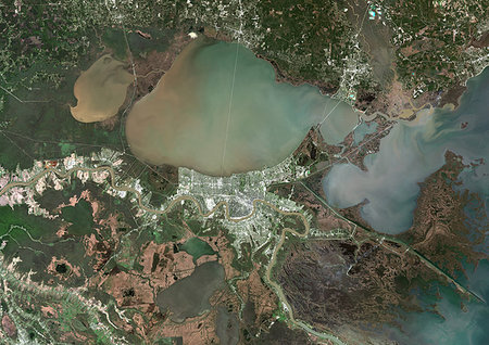
Color satellite image of Mississippi River Delta, Louisiana, United States. Image collected on February 10, 2017 by Sentinel-2 satellites.
Rights-Managed
-
Color satellite image of Brooklyn, New York City, New York State, United States. Brooklyn is one borough of New York City. It lies at the southwestern end of Long Island. Image collected on October 20, 2017 by Sentinel-2 satellites.
Rights-Managed
-
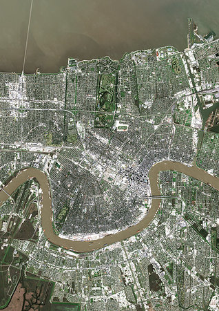
Color satellite image of New Orleans, Louisiana, United States. The city is located in the Mississippi River Delta, south of Lake Pontchartrain, on the banks of the Mississippi River. Image collected on February 10, 2017 by Sentinel-2 satellites.
Rights-Managed
-

Color satellite image of New Orleans, Louisiana, United States. The city is located in the Mississippi River Delta, south of Lake Pontchartrain, on the banks of the Mississippi River. Image collected on February 10, 2017 by Sentinel-2 satellites.
Rights-Managed
-
Color satellite image of New Orleans, Louisiana, United States. The city is located in the Mississippi River Delta, south of Lake Pontchartrain, on the banks of the Mississippi River. Image collected on February 10, 2017 by Sentinel-2 satellites.
Rights-Managed
-
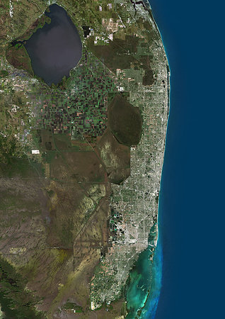
Color satellite image of Miami Metropolitan Area, Florida, United States. The Everglades natural region is at west and Biscayne National Park at south. Image collected on January 06, 2017 by Sentinel-2 satellites.
Rights-Managed
-
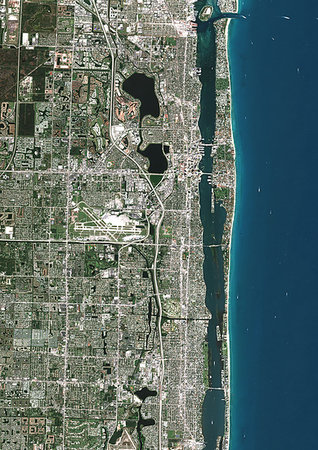
Color satellite image of Palm Beach, Florida, United States, with Palm Beach International Airport. Image collected on January 06, 2017 by Sentinel-2 satellites.
Rights-Managed
-
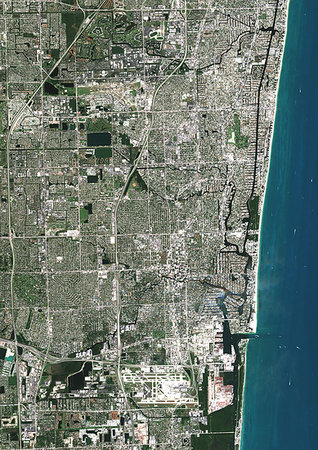
Color satellite image of Fort Lauderdale, Florida, United States. Image collected on January 06, 2017 by Sentinel-2 satellites.
Rights-Managed
-

Color satellite image of Miami Beach, Florida, United States. Image collected on January 06, 2017 by Sentinel-2 satellites.
Rights-Managed
-
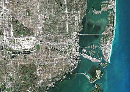
Color satellite image of Miami, Florida, United States, with Miami International Airport. Image collected on January 06, 2017 by Sentinel-2 satellites.
Rights-Managed
-
Color satellite image of Los Angeles to San Bernarnido, California, United States. Image collected on June 13, 2017 by Sentinel-2 satellites.
Rights-Managed
-

Color satellite image of Long Beach, California, United States. Image collected on June 13, 2017 by Sentinel-2 satellites.
Rights-Managed
-

Color satellite image of Los Angeles International Airport, California, United States. Image collected on June 13, 2017 by Sentinel-2 satellites.
Rights-Managed
-

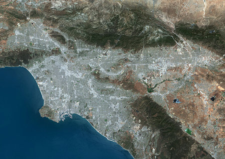
Color satellite image of Los Angeles, California, United States. Image collected on June 13, 2017 by Sentinel-2 satellites.
Rights-Managed
-

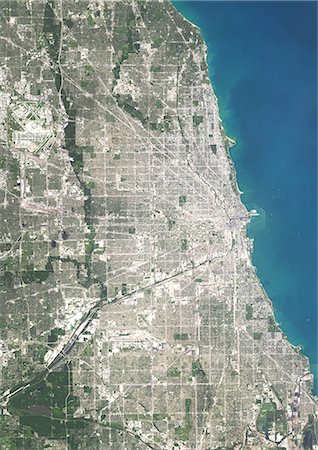
Color satellite image of Chicago, Illinois, United States. The city is located at the south western tip of Lake Michigan. Image collected on October 08, 2017 by Sentinel-2 satellites.
Rights-Managed
-

Color satellite image of Chicago, Illinois, United States. The city is located at the south western tip of Lake Michigan. Chicago O'Hare International Airport is at upper left. Image collected on October 08, 2017 by Sentinel-2 satellites.
Rights-Managed
-
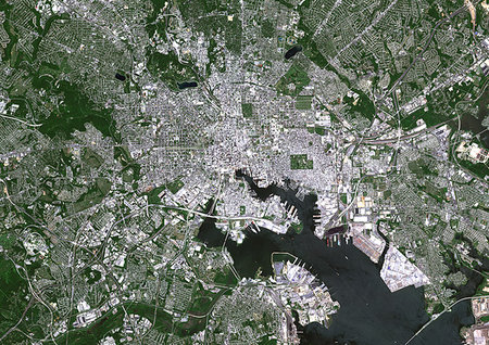
Color satellite image of Baltimore, Maryland, United States. Image collected on May 16, 2017 by Sentinel-2 satellites.
Rights-Managed
-

Color satellite image of Riga, capital city of Latvia. Image collected on May 28, 2017 by Sentinel-2 satellites.
Rights-Managed
-

Colour satellite image of San Francisco and San Jose, United States. Image taken on July 24, 2014 with Landsat 8 data.
Rights-Managed
-

Colour satellite image of Miami, Florida, USA. Image taken on November 2, 2014 with Landsat 8 data.
Rights-Managed
-

Colour satellite image of Los Angeles, California, USA. Image taken on October 23, 2014 with Landsat 8 data.
Rights-Managed
-

Colour satellite image of Las Vegas, Nevada, USA. Image taken on September 23, 2014 with Landsat 8 data.
Rights-Managed
-
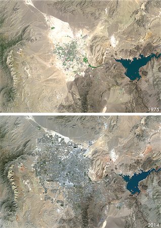
Satellite view of Las Vegas, Nevada, USA in 1975 and 2013. This before and after image shows urban expansion over the years.
Rights-Managed
-

Satellite view of Las Vegas, Nevada, USA in 1975, 2000 and 2013. This before and after image shows urban expansion over the years.
Rights-Managed
-
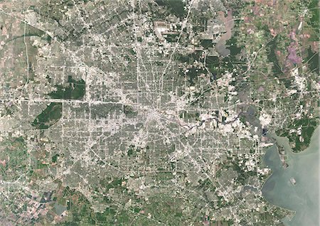
Colour satellite image of Houston, Texas, USA. Image taken on May 16, 2014 with Landsat 8 data.
Rights-Managed
-
Colour satellite image of Chicago, Illinois, USA. Image taken on August 15, 2014 with Landsat 8 data.
Rights-Managed
-

Colour satellite image of Chicago, Illinois, USA. Image taken on August 15, 2014 with Landsat 8 data.
Rights-Managed
-
Color satellite image of Lake Superior, North America. Image collected on May 1, 2016 by Landsat 8 satellite.
Rights-Managed
-

Color satellite image of Lake Ontario, North America. Image collected on May 1, 2016 by Landsat 8 satellite.
Rights-Managed
-
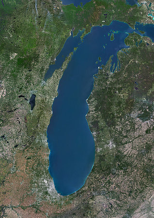
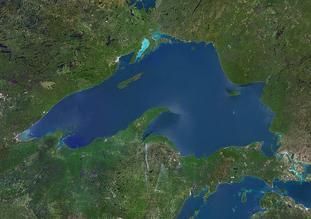
Color satellite image of Lake Michigan, United States. Image collected on May 1, 2016 by Landsat 8 satellite.
Rights-Managed
-

Color satellite image of Lake Huron, North America. Image collected on May 1, 2016 by Landsat 8 satellite.
Rights-Managed
-

Color satellite image of Lake Erie, North America. Image collected on May 1, 2016 by Landsat 8 satellite.
Rights-Managed
-
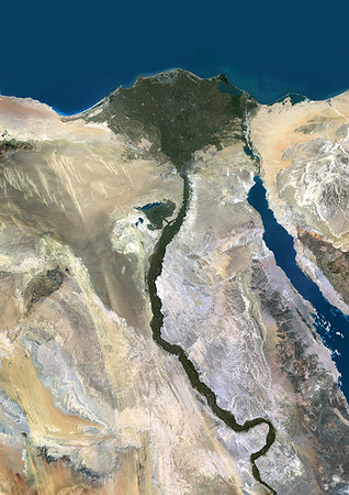
Color satellite image of the Nile River, Egypt. The Nile Delta is formed in Northern Egypt where the Nile River spreads out and drains into the Mediterranean Sea. Images collected on October 1, 2017 by Landsat 8 satellite.
Rights-Managed
-

Color satellite image of the Nile Delta. It is formed in Northern Egypt where the Nile River spreads out and drains into the Mediterranean Sea. Image collected on October 1, 2017 by Sentinel-2 satellites.
Rights-Managed
-
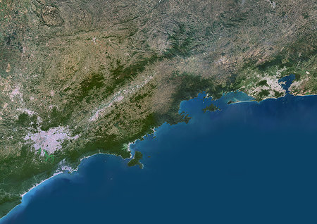
Color satellite image of Sao Paulo to Rio de Janeiro, Brazil. Image collected on May 1, 2017 by Sentinel-2 satellites.
Rights-Managed
-

Color satellite image of Lima, capital city of Peru. Image collected on February 20, 2017 by Sentinel-2 satellites.
Rights-Managed
-
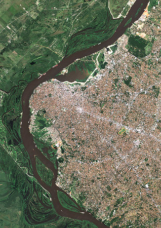
Color satellite image of Asuncion, capital city of Paraguay. Image collected on June 23, 2017 by Sentinel-2 satellites.
Rights-Managed
-

Color satellite image of Rio de Janeiro, Brazil. Image collected on March 10, 2017 by Sentinel-2 satellites.
Rights-Managed
-

Color satellite image of Rio de Janeiro, Brazil. Image collected on March 10, 2017 by Sentinel-2 satellites.
Rights-Managed
-

Color satellite image of Rio de Janeiro, Brazil. Image collected on March 10, 2017 by Sentinel-2 satellites.
Rights-Managed
-

Color satellite image of Guanabara Bay, Rio de Janeiro, Brazil. Image collected on March 10, 2017 by Sentinel-2 satellites.
Rights-Managed
-
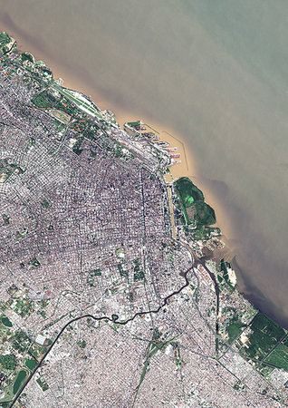
Color satellite image of Buenos Aires, capital city of Argentina. Image collected on April 14, 2017 by Sentinel-2 satellites.
Rights-Managed
-

Color satellite image of Buenos Aires, capital city of Argentina. Image collected on April 14, 2017 by Sentinel-2 satellites.
Rights-Managed
-

Color satellite image of Sydney, Botany Bay, Australia. Image collected on August 23, 2017 by Sentinel-2 satellites.
Rights-Managed
-

Color satellite image of Sydney, Australia. Image collected on August 23, 2017 by Sentinel-2 satellites.
Rights-Managed
-

Color satellite image of Port Adelaide, Australia. Image collected on March 18, 2017 by Sentinel-2 satellites.
Rights-Managed
-

Color satellite image of Perth, Australia. Image collected on August 25, 2017 by Sentinel-2 satellites.
Rights-Managed
-

Color satellite image of Melbourne, Australia. Image collected on March 9, 2017 by Sentinel-2 satellites.
Rights-Managed
-

Color satellite image of Brisbane, Australia. Image collected on July 24, 2017 by Sentinel-2 satellites.
Rights-Managed


