-

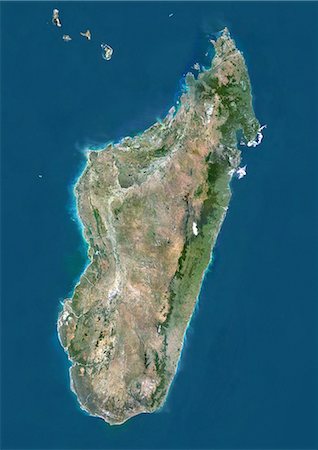
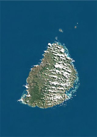
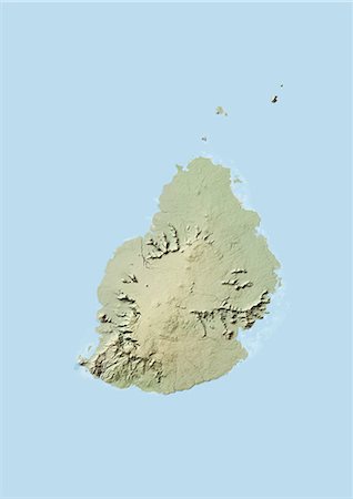
Satellite view of Madagascar. Comoros and Mayotte islands are at North. This image was compiled from data acquired by Landsat satellites.
Rights-Managed
-
-

-

-

Satellite view of Tenerife, Canary Islands, Spain. It is the largest and most populous island of the seven Canary Islands. Volcano Mount Teide at center is the highest point of Spain, at 3718 m. This image was compiled from data acquired by Landsat 8 satellite in 2014.
Rights-Managed
-

Satellite view of Southern Africa. It shows the African Great Lakes region. This image was compiled from data acquired by Landsat 7 & 8 satellites.
Rights-Managed
-

Satellite view of North Africa. This image was compiled from data acquired by Landsat 7 & 8 satellites.
Rights-Managed
-

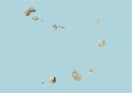
Satellite view of Cape Verde Southern Islands showing Fogo, Santiago and Miao islands. This image was compiled from data acquired by Landsat satellites.
Rights-Managed
-
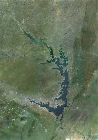
Satellite view of Lake Volta, in Ghana. It is the largest reservoir by surface area in the world, and the fourth largest by volume. This image was compiled from data acquired by Landsat satellites.
Rights-Managed
-
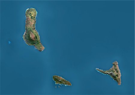
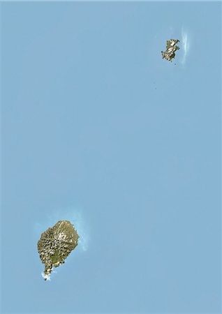
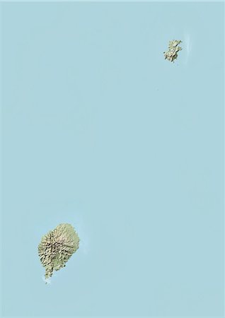
Satellite view of the Comoros Archipelago. This image was compiled from data acquired by Landsat satellites.
Rights-Managed
-

Satellite view of Africa. This image was compiled from data acquired by Landsat 7 & 8 satellites.
Rights-Managed
-

Satellite view of West Nusa Tenggara Province, Indonesia (with country boundaries and mask). The image shows the two largest islands in the province which are Lombok in the west and the larger Sumbawa island in the east. This image was compiled from data acquired by Landsat satellites.
Rights-Managed
-
Satellite view of Viti Levu Island, Fiji. This is the largest island in the Republic of Fiji and the site of the nation's capital, Suva. This image was compiled from data acquired by Landsat 8 satellite in 2014.
Rights-Managed
-
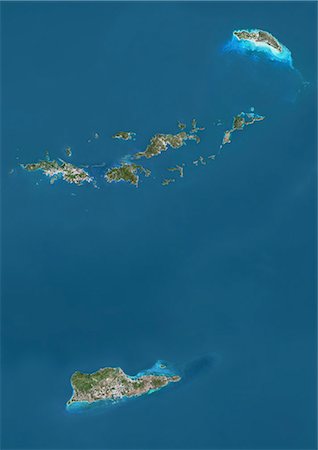
Satellite view of British and US Virgin Islands. This image was compiled from data acquired by Landsat satellites.
Rights-Managed
-

Satellite view of Vanua Balavu Island, Fiji. This image was compiled from data acquired by Landsat 8 satellite in 2014.
Rights-Managed
-
Satellite view of Turks and Caicos Islands. This image was compiled from data acquired by Landsat satellites.
Rights-Managed
-
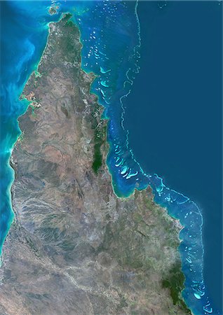
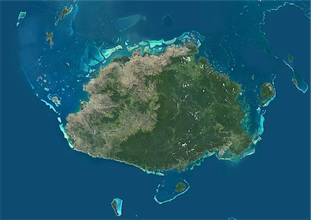
Satellite view of the Northern Great Barrier Reef along the east coast of Cape York Peninsula in north Australia. This image was compiled from data acquired in 2014 by Landsat 8 satellite.
Rights-Managed
-

Satellite view of Taiwan. This image was compiled from data acquired by Landsat satellites.
Rights-Managed
-
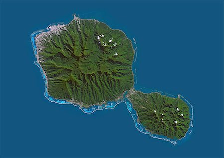
Satellite view of Tahiti, French Polynesia. This image was compiled from data acquired by Landsat 8 satellite in 2014.
Rights-Managed
-
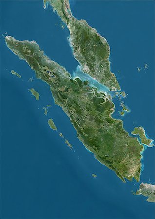
Satellite view of Sumatra, Malaysia and Singapore. This image was compiled from data acquired by Landsat satellites.
Rights-Managed
-
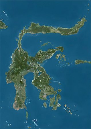
Satellite view of Sulawesi, Indonesia. This image was compiled from data acquired by Landsat satellites.
Rights-Managed
-
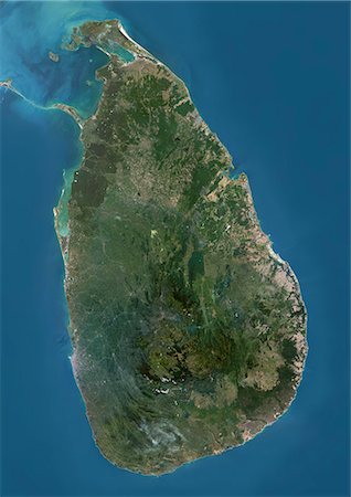
Satellite view of Sri Lanka. This image was compiled from data acquired by Landsat 8 satellite in 2014.
Rights-Managed
-
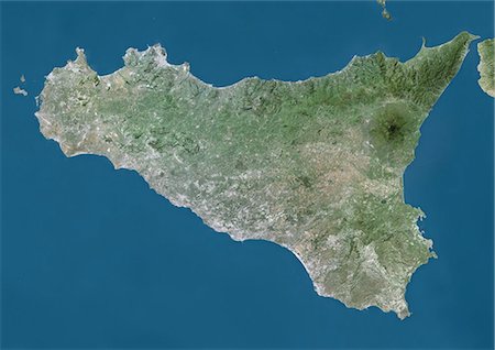
Satellite view of Sicily, Italy. Mount Etna, on the East coast of Sicily, is the largest active volcano in Europe. This image was compiled from data acquired by Landsat satellites.
Rights-Managed
-
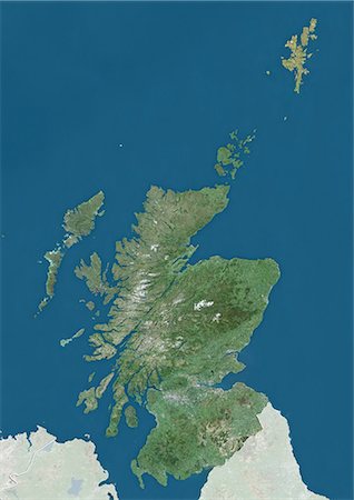
Satellite view of Scotland and the Northern Isles, UK (with country boundaries and mask). The image shows the mainland of Scotland, including the Northern Isles and the Hebrides. This image was compiled from data acquired by Landsat satellites.
Rights-Managed
-

Satellite view of Sardinia, Italy. It is the second-largest island in the Mediterranean Sea. This image was compiled from data acquired by Landsat satellites.
Rights-Managed
-
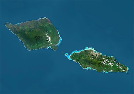
Satellite view of Samoa that consists of two large islands, Upolu and Savaii. This image was compiled from data acquired by Landsat 8 satellite in 2014.
Rights-Managed
-

Satellite view of Puerto Rico. This image was compiled from data acquired by Landsat satellites.
Rights-Managed
-

Satellite view of New Zealand. This image was compiled from data acquired by Landsat 8 satellite in 2014.
Rights-Managed
-
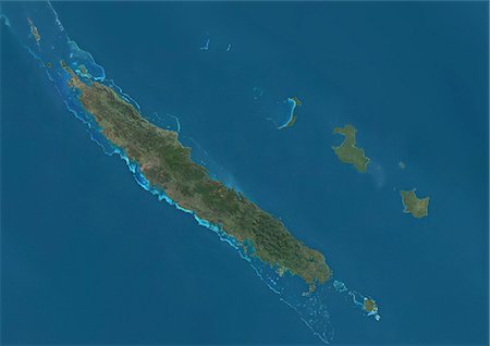
Satellite view of New Caledonia. This image was compiled from data acquired by Landsat satellites.
Rights-Managed
-
Satellite view of the Marquesas Islands, French Polynesia. This image was compiled from data acquired by Landsat 8 satellite in 2014.
Rights-Managed
-

Satellite view of the Maluku Islands, Indonesia. This image was compiled from data acquired by Landsat satellites.
Rights-Managed
-

Satellite view of Japan and Korean Peninsula. This image was compiled from data acquired by Landsat satellites.
Rights-Managed
-

Satellite view of Japan and Korean Peninsula. This image was compiled from data acquired by Landsat satellites.
Rights-Managed
-
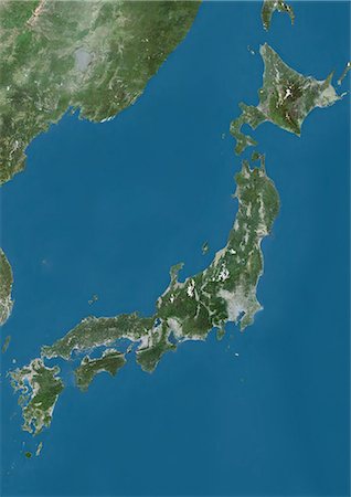
Satellite view of Japan. This image was compiled from data acquired by Landsat satellites.
Rights-Managed
-
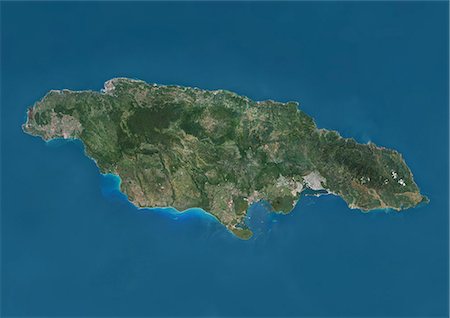
Satellite view of Jamaica. This image was compiled from data acquired by Landsat satellites.
Rights-Managed
-
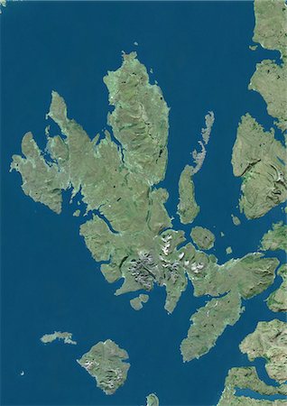
Satellite view of the Isle of Skye, Scotland. It is the largest island in the Inner Hebrides of Scotland. The Cuillin mountains dominate the Isle of Skye. This image was compiled from data acquired by Landsat satellites.
Rights-Managed
-
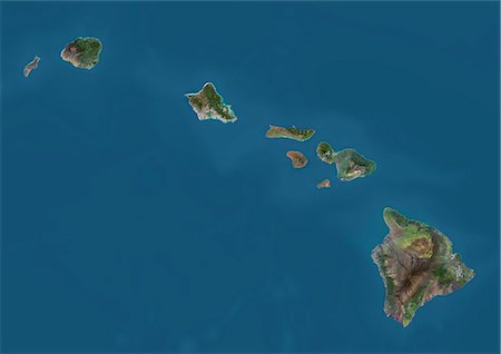
Satellite view of the State of Hawaii, USA. The main islands are Kauai, Oahu, Maui and the Island of Hawaii. This image was compiled from data acquired by Landsat 8 satellite in 2014.
Rights-Managed
-

Satellite view of the Island of Hawaii, USA. The island is formed of five volcanoes, Mauna Loa being the largest. This image was compiled from data acquired by Landsat 8 satellite in 2014.
Rights-Managed
-

Satellite view of Haiti and The Dominican Republic. This image was compiled from data acquired by Landsat satellites.
Rights-Managed
-
Satellite view of Guadeloupe, Dominica and Martinique. This image was compiled from data acquired by Landsat satellites.
Rights-Managed
-

Satellite view of Guadeloupe. This image was compiled from data acquired by Landsat satellites.
Rights-Managed
-
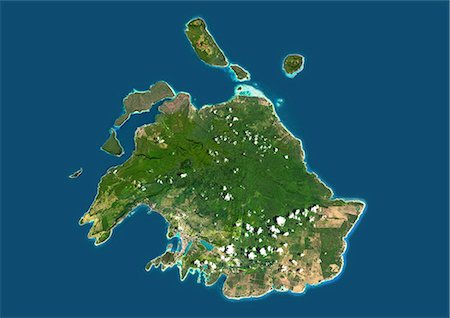
Satellite view of Efate, Vanuatu. It is the most populous island of Vanuatu archipelago. This image was compiled from data acquired by Landsat 8 satellite in 2014.
Rights-Managed
-
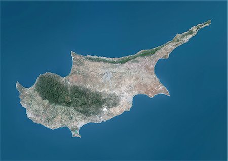
Satellite view of Cyprus. This image was compiled from data acquired by Landsat 8 satellite in 2014.
Rights-Managed
-
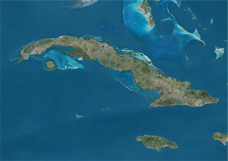
Satellite view of Cuba and Jamaica. This image was compiled from data acquired by Landsat satellites.
Rights-Managed
-
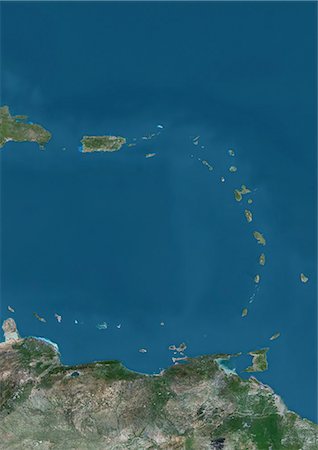
Satellite view of Islands of the Lesser Antilles and Puerto Rico and Puerto Rico in the Caribbean. This image was compiled from data acquired by Landsat satellites.
Rights-Managed
-
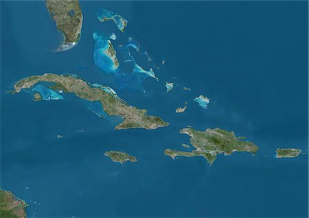
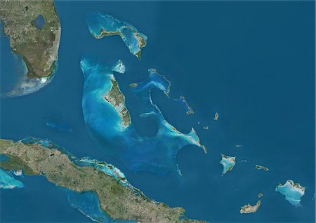
Satellite view of The Greater Antilles and Bahamas. This image was compiled from data acquired by Landsat satellites.
Rights-Managed
-

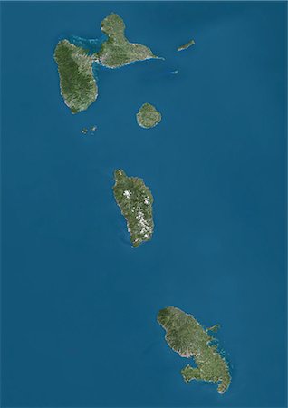
Satellite view of the Caribbean Sea. The entire area of the Caribbean Sea, including all islands of the West Indies is collectively known as the Caribbean. This image was compiled from data acquired by Landsat satellites.
Rights-Managed
-
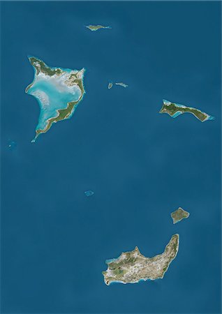
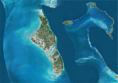
Satellite view of Bahamas Southern Islands comprising Acklins and Crooked Island, Inagua and Mayaguana. This image was compiled from data acquired by Landsat satellites.
Rights-Managed
-

Satellite view of Andros Islands and New Providence, Bahamas. New Providence is the most populous island in the Bahamas and it houses the capital city of Nassau. This image was compiled from data acquired by Landsat satellites.
Rights-Managed
-

Satellite view of Grand Bahama and Abaco Islands, Bahamas. This image was compiled from data acquired by Landsat satellites.
Rights-Managed
-
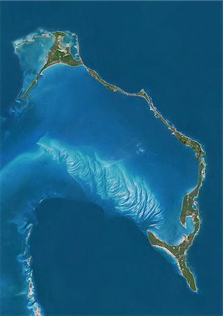
Satellite view of Eleuthera Island, Bahamas. This image was compiled from data acquired by Landsat satellites.
Rights-Managed
-
Satellite view of Andros, New Providence and Eleuthera Islands, Bahamas. New Providence is the most populous island in the Bahamas and it houses the capital city of Nassau. This image was compiled from data acquired by Landsat satellites.
Rights-Managed
-

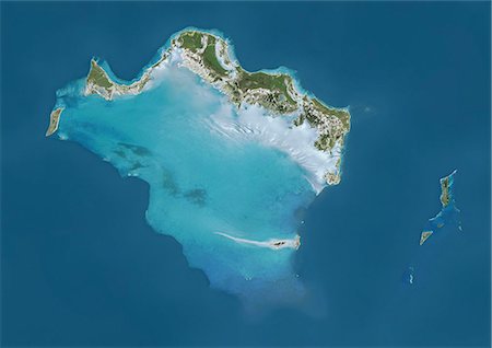
Satellite view of the Abaco Islands that lie in the northern Bahamas. They comprise the main islands of Great Abaco and Little Abaco, along with smaller barrier cays. This image was compiled from data acquired by Landsat satellites.
Rights-Managed
-
Satellite view of The Bahamas. It consists of more than 700 islands, cays and islets in the Atlantic Ocean, north of Cuba and southeast of the US state of Florida. The capital is Nassau on the island of New Providence. This image was compiled from data acquired by Landsat satellites.
Rights-Managed
-
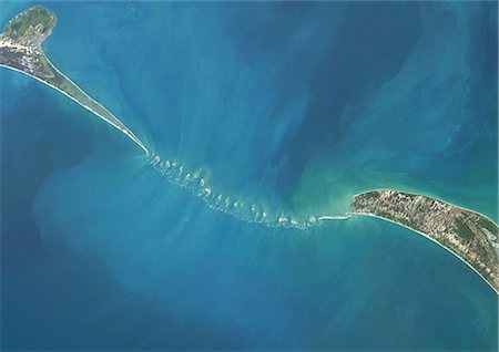
Satellite view of Adam's Bridge. This chain of limestone shoals connects Sri Lanka to India. This image was taken in 2014 by Landsat 8 satellite.
Rights-Managed
-
-
-
-
-
-

-
-
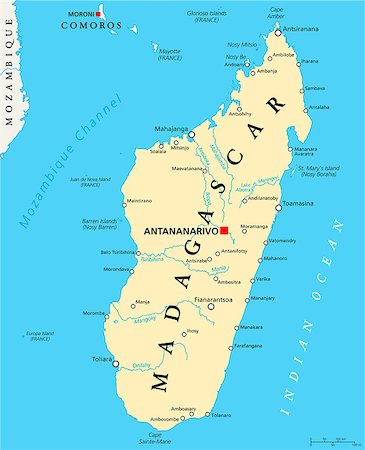
Madagascar Political Map with capital Antananarivo, national borders, important cities, rivers and lakes. English labeling and scaling. Illustration.
Aubaine LD & Abonnement
-

Color satellite image of Antananarivo, capital city of Madagascar. Image collected on May 11, 2017 by Sentinel-2 satellites.
Rights-Managed
-
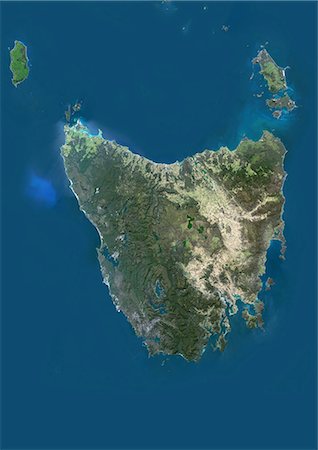
Satellite view of Tasmania, Australia. This image was compiled from data acquired by Landsat 8 satellite in 2014.
Rights-Managed
-

Satellite view of Southeast Asia. This image was compiled from data acquired by Landsat 7 & 8 satellites.
Rights-Managed
-
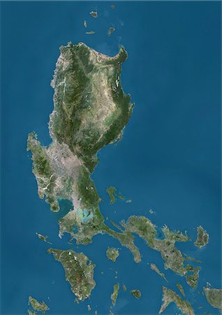
Satellite view of Luzon, Philippines. It is the largest and most populous island in the Philippines. This image was compiled from data acquired by Landsat satellites.
Rights-Managed
-

Satellite view of the Persian Gulf. This image was compiled from data acquired in 2014 by Landsat 8 satellite.
Rights-Managed
-

Satellite view of Oceania. This image was compiled from data acquired by Landsat 7 & 8 satellites.
Rights-Managed
-

Satellite view of the Kerguelen Islands, a group of islands in the southern Indian Ocean that is part of the French Southern and Antarctic Lands. The main island is called Grande Terre. This image was compiled from data acquired by Landsat satellites.
Rights-Managed
-

Satellite view of the Caucasus. This image was compiled from data acquired in 2014 by Landsat 8 satellite.
Rights-Managed
-

Satellite view of the Arabian Peninsula. This image was compiled from data acquired in 2014 by Landsat 8 satellite.
Rights-Managed
-
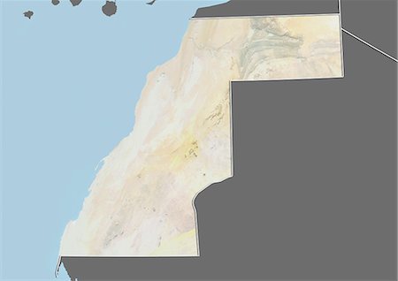
Carte du relief du Sahara occidental (avec bordure et masque). Cette image a été compilée à partir de données acquises par les satellites landsat 5 & 7 combinées avec les données d'élévation.
Rights-Managed
-
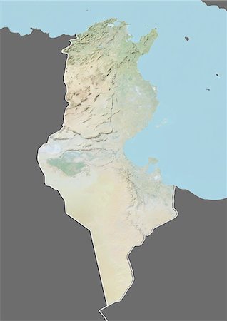
Plan-relief de Tunisie (avec bordure et masque). Cette image a été compilée à partir de données acquises par les satellites landsat 5 & 7 combinées avec les données d'élévation.
Rights-Managed
-
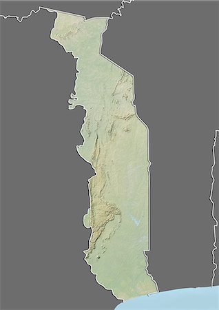
Carte du relief du Togo (avec bordure et masque). Cette image a été compilée à partir de données acquises par les satellites landsat 5 & 7 combinées avec les données d'élévation.
Rights-Managed
-
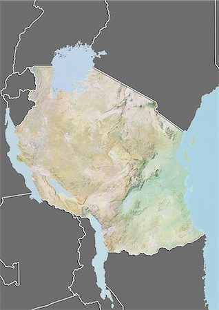
Plan-relief de Tanzanie (avec bordure et masque). Cette image a été compilée à partir de données acquises par les satellites landsat 5 & 7 combinées avec les données d'élévation.
Rights-Managed
-
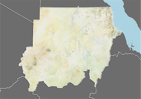
Plan-relief de Soudan (avec bordure et masque). Cette image a été compilée à partir de données acquises par les satellites landsat 5 & 7 combinées avec les données d'élévation.
Rights-Managed
-
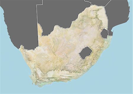
Plan-relief de l'Afrique du Sud (avec bordure et masque). Cette image a été compilée à partir de données acquises par les satellites landsat 5 & 7 combinées avec les données d'élévation.
Rights-Managed
-
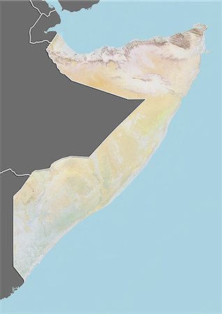
Plan-relief de Somalie (avec bordure et masque). Cette image a été compilée à partir de données acquises par les satellites landsat 5 & 7 combinées avec les données d'élévation.
Rights-Managed
-
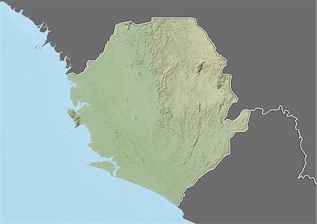
Plan-relief de Sierra Leone (avec bordure et masque). Cette image a été compilée à partir de données acquises par les satellites landsat 5 & 7 combinées avec les données d'élévation.
Rights-Managed
-

Carte du relief du Sénégal (avec bordure et masque). Cette image a été compilée à partir de données acquises par les satellites landsat 5 & 7 combinées avec les données d'élévation.
Rights-Managed
-
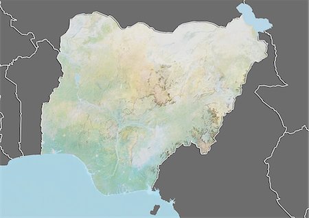
Carte du relief du Nigéria (avec bordure et masque). Cette image a été compilée à partir de données acquises par les satellites landsat 5 & 7 combinées avec les données d'élévation.
Rights-Managed
-

Plan-relief de Namibie (avec bordure et masque). Cette image a été compilée à partir de données acquises par les satellites landsat 5 & 7 combinées avec les données d'élévation.
Rights-Managed
-
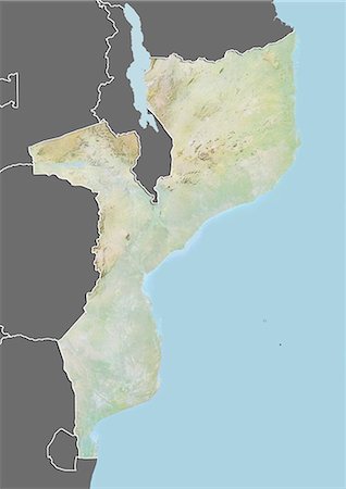
Plan-relief de Mozambique (avec bordure et masque). Cette image a été compilée à partir de données acquises par les satellites landsat 5 & 7 combinées avec les données d'élévation.
Rights-Managed
-
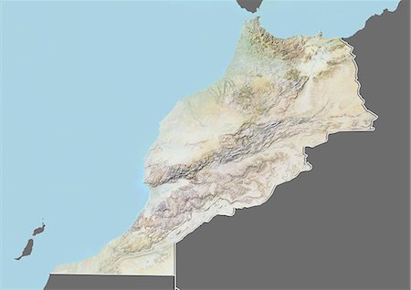
Carte du relief du Maroc (avec bordure et masque). Cette image a été compilée à partir de données acquises par les satellites landsat 5 & 7 combinées avec les données d'élévation.
Rights-Managed
-
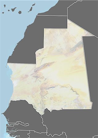
Plan-relief de Mauritanie (avec bordure et masque). Cette image a été compilée à partir de données acquises par les satellites landsat 5 & 7 combinées avec les données d'élévation.
Rights-Managed
-
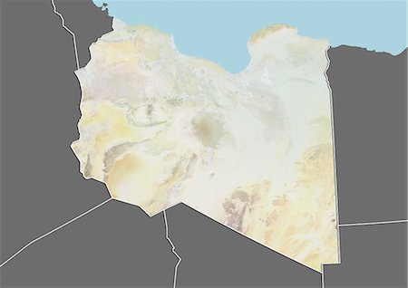
Plan-relief de Libye (avec bordure et masque). Cette image a été compilée à partir de données acquises par les satellites landsat 5 & 7 combinées avec les données d'élévation.
Rights-Managed
-
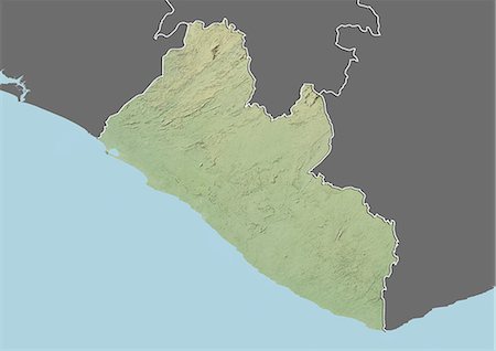
Plan-relief de Libéria (avec bordure et masque). Cette image a été compilée à partir de données acquises par les satellites landsat 5 & 7 combinées avec les données d'élévation.
Rights-Managed
-
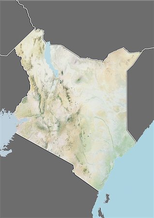
Carte du relief du Kenya (avec bordure et masque). Cette image a été compilée à partir de données acquises par les satellites landsat 5 & 7 combinées avec les données d'élévation.
Rights-Managed
-
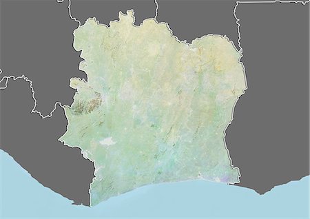
Plan-relief de la côte d'Ivoire (avec bordure et masque). Cette image a été compilée à partir de données acquises par les satellites landsat 5 & 7 combinées avec les données d'élévation.
Rights-Managed


