-

-

-
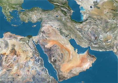
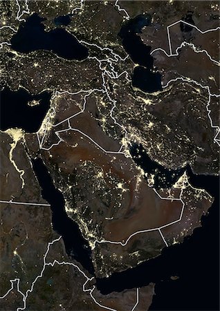
Satellite view of the Middle East. This image was compiled from data acquired in 2014 by Landsat 8 satellite.
Rights-Managed
-
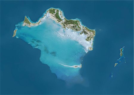
Satellite view of Turks and Caicos Islands. This image was compiled from data acquired by Landsat satellites.
Rights-Managed
-

-
-

-
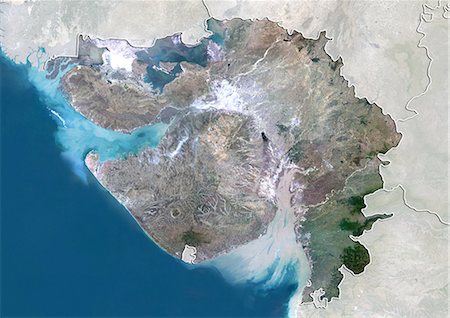
Vue satellite de l'état de Gujarat, en Inde. Cette image a été compilée à partir de données acquises par les satellites LANDSAT 5 & 7.
Rights-Managed
-

-

Plan-relief de l'état d'Uttar Pradesh, Inde. Cette image a été compilée à partir de données acquises par les satellites LANDSAT 5 & 7 combinées avec les données d'élévation.
Rights-Managed
-

-

-

-

-

-

-

-
-
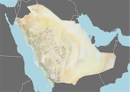
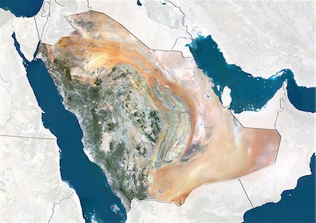
Plan-relief de l'Arabie saoudite (avec bordure et masque). Cette image a été compilée à partir de données acquises par les satellites landsat 5 & 7 combinées avec les données d'élévation.
Rights-Managed
-
-
-
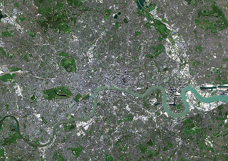
Color satellite image of London, capital city of England and the United Kingdom. The River Thames flows through London. Image collected on April 09, 2017 by Sentinel-2 satellites.
Rights-Managed
-

Color satellite image of Los Angeles International Airport, California, United States. Image collected on June 13, 2017 by Sentinel-2 satellites.
Rights-Managed
-

-
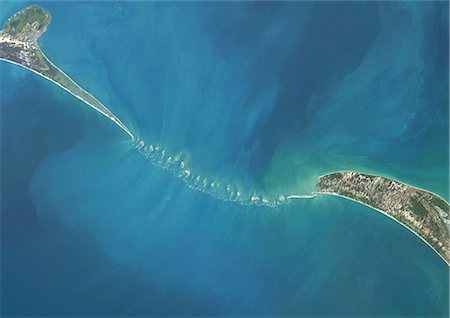
Satellite view of Adam's Bridge. This chain of limestone shoals connects Sri Lanka to India. This image was taken in 2014 by Landsat 8 satellite.
Rights-Managed
-

-

-

Satellite view of deforestation in East Rondonia, Brazil in 1986 and 2001. This before and after image shows deforestation impact over the years.
Rights-Managed
-
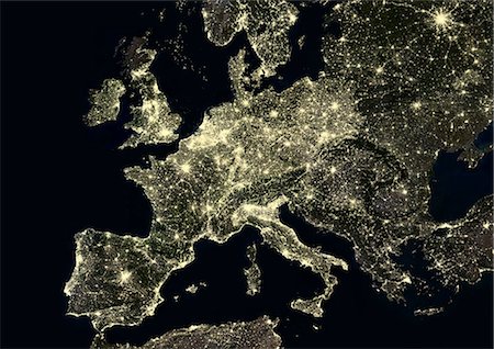
Western Europe at night in 2012, from Portugal to Moscow, Russia. This satellite image shows urban and industrial lights.
Rights-Managed
-

-

Color satellite image of Mumbai and Navi Mumbai, India. Navi Mumbai is a planned township located East of Mumbai. Both cities are connected by the Vashi bridge, also called Thane Creek Bridge. Image collected on May 03, 2017 by Sentinel-2 satellites.
Rights-Managed
-

-
Color satellite image of Riyadh, capital city of Saudi Arabia. Image collected on October 23, 2017 by Sentinel-2 satellites.
Rights-Managed
-
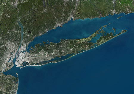
Color satellite image of Long Island, New York State, United States. Image collected on October 20, 2017 by Sentinel-2 satellites.
Rights-Managed
-

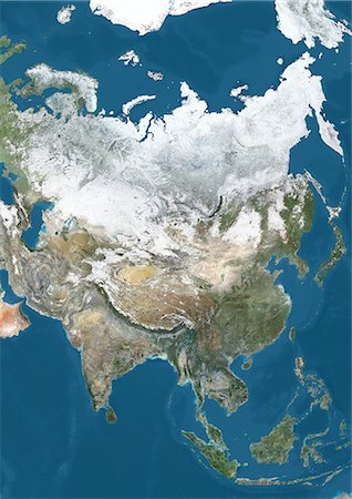
Satellite view of Asia. This image was compiled from data acquired by Landsat 7 & 8 satellites.
Rights-Managed
-
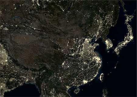
China at night in 2012. This satellite image shows urban and industrial lights.
Rights-Managed
-

Satellite view of Southern Africa. It shows the African Great Lakes region. This image was compiled from data acquired by Landsat 7 & 8 satellites.
Rights-Managed
-

-

International Currency, Pen Stock Certificates and Gold Bar On Antique World Map
Premium Libres de Droits
-

-

Planète terre avec des lumières de l'Amérique du Nord pendant la nuit
Premium Libres de Droits
-

-
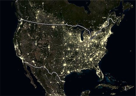
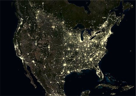
United States at night in 2012. This satellite image with country borders shows urban and industrial lights.
Rights-Managed
-

-

-

-

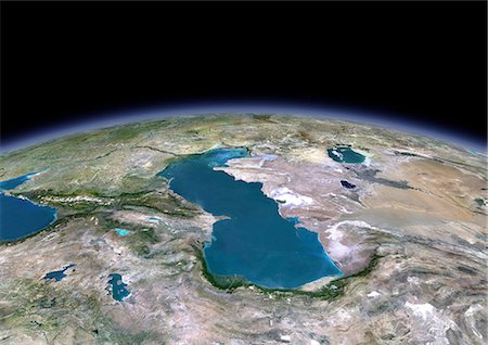
Satellite view of the Persian Gulf. This image was compiled from data acquired in 2014 by Landsat 8 satellite.
Rights-Managed
-

Vue satellite de la province de Shandong, Chine. Cette image a été compilée à partir de données acquises par les satellites LANDSAT 5 & 7.
Rights-Managed
-
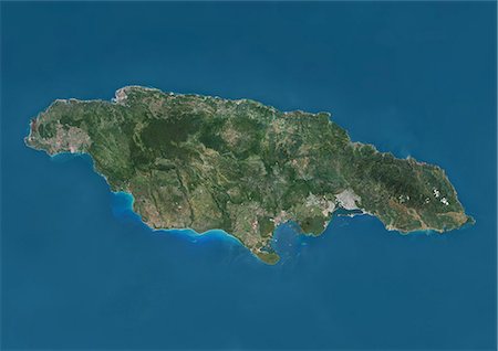
Satellite view of Jamaica. This image was compiled from data acquired by Landsat satellites.
Rights-Managed
-

-

Colour satellite image of New Orleans, Louisiana, USA. Image taken on November 3, 2014 with Landsat 8 data.
Rights-Managed
-

Middle East and India at night in 2012. This satellite image with country borders shows urban and industrial lights.
Rights-Managed
-

-

Color satellite image of Southern Florida, United States. It shows Miami at east, Everglades National Park at center, and the Florida Keys at south. Image collected on January 06, 2017 by Sentinel-2 satellites.
Rights-Managed
-

Satellite view of Haiti and The Dominican Republic. This image was compiled from data acquired by Landsat satellites.
Rights-Managed
-
-

-

-

Color satellite image of Jerusalem, capital city of Israel. Image collected on October 18, 2017 by Sentinel-2 satellites.
Rights-Managed
-
-

Eastern Europe and Scandinavia at night in 2012. This satellite image with country borders shows urban and industrial lights.
Rights-Managed
-

-
Satellite view of Asia in winter, with partial snow cover. This image was compiled from data acquired by Landsat 7 & 8 satellites.
Rights-Managed
-
-
-

Color satellite image of Kigali, capital city of Rwanda. Image collected on August 31, 2016 by Sentinel-2 satellites.
Rights-Managed
-
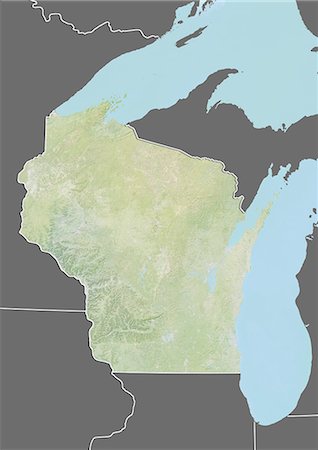
Plan-relief de l'état du Wisconsin, aux États-Unis. Cette image a été compilée à partir de données acquises par les satellites LANDSAT 5 & 7 combinées avec les données d'élévation.
Rights-Managed
-
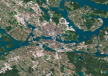
Color satellite image of Stockholm, capital city of Sweden. Image collected on July 06, 2017 by Sentinel-2 satellites.
Rights-Managed
-

International Currency, Pen Stock Certificates and Gold Bar On Antique World Map
Premium Libres de Droits
-
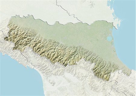
Plan-relief de la région d'Emilia Romagna, Italie. Cette image a été compilée à partir de données acquises par les satellites LANDSAT 5 & 7 combinées avec les données d'élévation.
Rights-Managed
-

Vue satellite de Terre-Neuve- et -Labrador, Canada. Cette image a été compilée à partir de données acquises par les satellites LANDSAT 5 & 7.
Rights-Managed
-

Color satellite image of New York City to Washington D.C. on the East Coast of the United States. Image collected on May 1, 2017 by Sentinel-2 satellites.
Rights-Managed
-
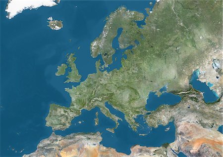
Satellite view of Europe. This image was compiled from data acquired by Landsat 7 & 8 satellites.
Rights-Managed
-

Vue satellite de l'état du Bengale, Inde. Cette image a été compilée à partir de données acquises par les satellites LANDSAT 5 & 7.
Rights-Managed
-
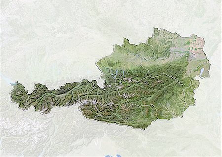
Autriche, Image Satellite avec effet de relief, avec les frontières des États-
Rights-Managed
-

Satellite view of Taiwan. This image was compiled from data acquired by Landsat satellites.
Rights-Managed
-

-
Middle East at night in 2012, with Saudi Arabia. This satellite image with country borders shows urban and industrial lights.
Rights-Managed
-
Color satellite image of Sarajevo, capital city of Bosnia and Herzegovina. Image collected on July 14, 2017 by Sentinel-2 satellites.
Rights-Managed
-

-

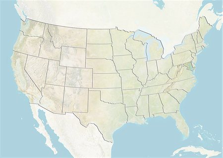
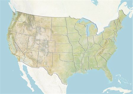
Des États-Unis et l'état de l'Idaho, Image Satellite avec effet de relief
Rights-Managed
-

Passeport, stylo, carte d'or, argent lunettes de soleil, chèques de voyage et carte
Rights-Managed
-
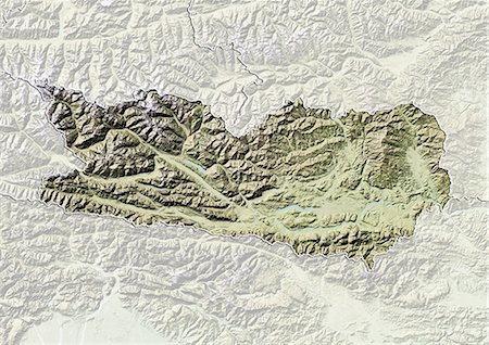
Carte du relief du Land de Carinthie, Autriche. Cette image a été compilée à partir de données acquises par les satellites LANDSAT 5 & 7 combinées avec les données d'élévation.
Rights-Managed
-

Satellite view of Andros Islands and New Providence, Bahamas. New Providence is the most populous island in the Bahamas and it houses the capital city of Nassau. This image was compiled from data acquired by Landsat satellites.
Rights-Managed
-
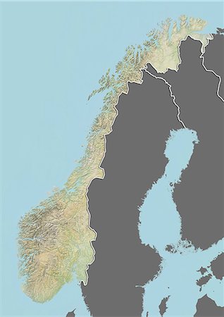
Plan-relief de la Norvège (avec bordure et masque). Cette image a été compilée à partir de données acquises par les satellites landsat 5 & 7 combinées avec les données d'élévation.
Rights-Managed
-
-

Satellite image of the Ganges River Delta, Bangladesh, India. Also known as the Brahmaputra Delta, it empties into the Bay of Bengal. Kolkata sits within the lower Ganges Delta along the Hooghly River (at west on the image). Image collected on March 16, 2017 by Sentinel-2 satellites.
Rights-Managed
-
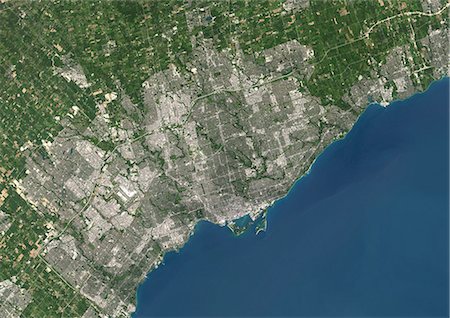
Colour satellite image of Toronto, Ontario, Canada. Image taken on August 19, 2014 with Landsat 8 data.
Rights-Managed
-
United States at night in 2012. This satellite image shows urban and industrial lights.
Rights-Managed
-

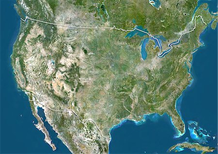
Satellite view of the Caribbean Sea. The entire area of the Caribbean Sea, including all islands of the West Indies is collectively known as the Caribbean. This image was compiled from data acquired by Landsat satellites.
Rights-Managed


