-

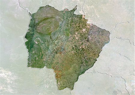
Satellite view of the State of Minas Gerais, Brazil. This image was compiled from data acquired by LANDSAT 5 & 7 satellites.
Con derechos protegidos
-
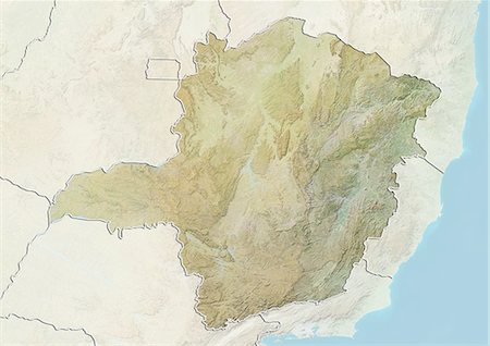
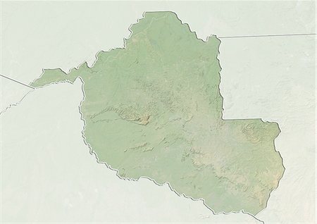
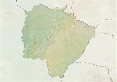
Relief map of the State of Minas Gerais, Brazil. This image was compiled from data acquired by LANDSAT 5 & 7 satellites combined with elevation data.
Con derechos protegidos
-

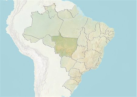
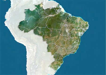
Brazil and the State of Minas Gerais, True Colour Satellite Image
Con derechos protegidos
-

-

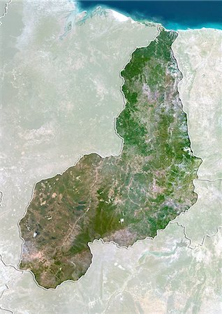
Satellite view of the State of Tocantins, Brazil. This image was compiled from data acquired by LANDSAT 5 & 7 satellites.
Con derechos protegidos
-

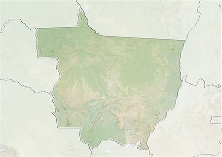
Relief map of the State of Tocantins, Brazil. This image was compiled from data acquired by LANDSAT 5 & 7 satellites combined with elevation data.
Con derechos protegidos
-

Satellite view of the State of Sergipe, Brazil. This image was compiled from data acquired by LANDSAT 5 & 7 satellites.
Con derechos protegidos
-

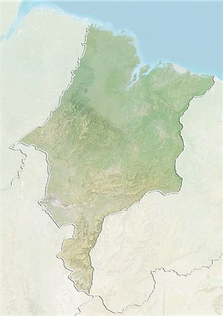
Relief map of the State of Sergipe, Brazil. This image was compiled from data acquired by LANDSAT 5 & 7 satellites combined with elevation data.
Con derechos protegidos
-
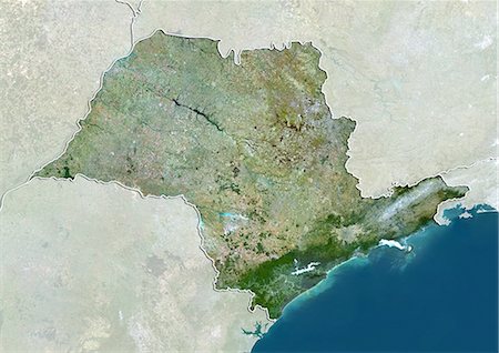
Satellite view of the State of Sao Paulo, Brazil. This image was compiled from data acquired by LANDSAT 5 & 7 satellites.
Con derechos protegidos
-

Relief map of the State of Sao Paulo, Brazil. This image was compiled from data acquired by LANDSAT 5 & 7 satellites combined with elevation data.
Con derechos protegidos
-

Satellite view of the State of Santa Catarina, Brazil. This image was compiled from data acquired by LANDSAT 5 & 7 satellites.
Con derechos protegidos
-

Relief map of the State of Santa Catarina, Brazil. This image was compiled from data acquired by LANDSAT 5 & 7 satellites combined with elevation data.
Con derechos protegidos
-
Satellite view of the State of Rondonia, Brazil. This image is from 2003 and compiled from data acquired by LANDSAT 7 satellite.
Con derechos protegidos
-

Satellite view of the State of Rondonia, Brazil. This image is from 1990 and compiled from data acquired by LANDSAT 5 satellite.
Con derechos protegidos
-
Relief map of the State of Rondonia, Brazil. This image is from 2003 and compiled from data acquired by LANDSAT 7 satellite combined with elevation data.
Con derechos protegidos
-

Relief map of the State of Rondonia, Brazil. This image is from 1990 and compiled from data acquired by LANDSAT 5 satellite combined with elevation data.
Con derechos protegidos
-

Satellite view of the State of Rio Grande do Sul, Brazil. This image was compiled from data acquired by LANDSAT 5 & 7 satellites.
Con derechos protegidos
-

Relief map of the State of Rio Grande do Sul, Brazil. This image was compiled from data acquired by LANDSAT 5 & 7 satellites combined with elevation data.
Con derechos protegidos
-

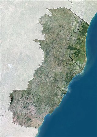
Satellite view of the State of Rio Grande do Norte, Brazil. This image was compiled from data acquired by LANDSAT 5 & 7 satellites.
Con derechos protegidos
-

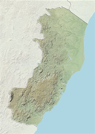
Relief map of the State of Rio Grande do Norte, Brazil. This image was compiled from data acquired by LANDSAT 5 & 7 satellites combined with elevation data.
Con derechos protegidos
-
Satellite view of the State of Rio de Janeiro, Brazil. This image was compiled from data acquired by LANDSAT 5 & 7 satellites.
Con derechos protegidos
-

Relief map of the State of Rio de Janeiro, Brazil. This image was compiled from data acquired by LANDSAT 5 & 7 satellites combined with elevation data.
Con derechos protegidos
-
Satellite view of the State of Piaui, Brazil. This image was compiled from data acquired by LANDSAT 5 & 7 satellites.
Con derechos protegidos
-

Relief map of the State of Piaui, Brazil. This image was compiled from data acquired by LANDSAT 5 & 7 satellites combined with elevation data.
Con derechos protegidos
-

Satellite view of the State of Pernambuco, Brazil. This image was compiled from data acquired by LANDSAT 5 & 7 satellites.
Con derechos protegidos
-

Relief map of the State of Pernambuco, Brazil. This image was compiled from data acquired by LANDSAT 5 & 7 satellites combined with elevation data.
Con derechos protegidos
-

Satellite view of the State of Parana, Brazil. This image was compiled from data acquired by LANDSAT 5 & 7 satellites.
Con derechos protegidos
-
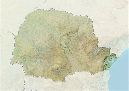
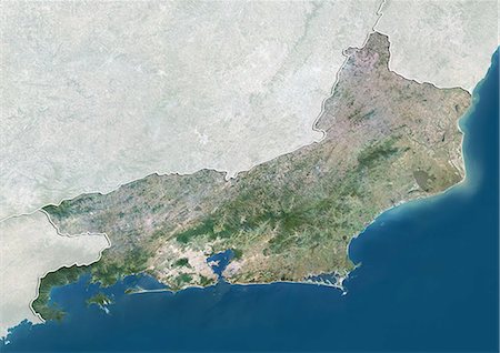
Relief map of the State of Parana, Brazil. This image was compiled from data acquired by LANDSAT 5 & 7 satellites combined with elevation data.
Con derechos protegidos
-

Satellite view of the State of Paraiba, Brazil. This image was compiled from data acquired by LANDSAT 5 & 7 satellites.
Con derechos protegidos
-

Relief map of the State of Paraiba, Brazil. This image was compiled from data acquired by LANDSAT 5 & 7 satellites combined with elevation data.
Con derechos protegidos
-

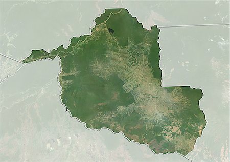
Satellite view of the State of Para, Brazil. This image was compiled from data acquired by LANDSAT 5 & 7 satellites.
Con derechos protegidos
-

Relief map of the State of Para, Brazil. This image was compiled from data acquired by LANDSAT 5 & 7 satellites combined with elevation data.
Con derechos protegidos
-
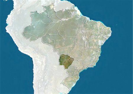
Satellite view of the State of Mato Grosso do Sul, Brazil. This image was compiled from data acquired by LANDSAT 5 & 7 satellites.
Con derechos protegidos
-
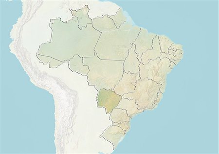
Relief map of the State of Mato Grosso do Sul, Brazil. This image was compiled from data acquired by LANDSAT 5 & 7 satellites combined with elevation data.
Con derechos protegidos
-

Satellite view of the State of Mato Grosso, Brazil. This image was compiled from data acquired by LANDSAT 5 & 7 satellites.
Con derechos protegidos
-
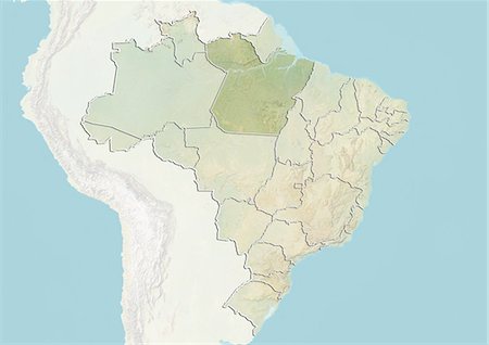
Relief map of the State of Mato Grosso, Brazil. This image was compiled from data acquired by LANDSAT 5 & 7 satellites combined with elevation data.
Con derechos protegidos
-

Satellite view of the State of Maranhao, Brazil. This image was compiled from data acquired by LANDSAT 5 & 7 satellites.
Con derechos protegidos
-
Relief map of the State of Maranhao, Brazil. This image was compiled from data acquired by LANDSAT 5 & 7 satellites combined with elevation data.
Con derechos protegidos
-

Satellite view of the State of Goias, Brazil. This image was compiled from data acquired by LANDSAT 5 & 7 satellites.
Con derechos protegidos
-

Relief map of the State of Goias, Brazil. This image was compiled from data acquired by LANDSAT 5 & 7 satellites combined with elevation data.
Con derechos protegidos
-
Satellite view of the State of Espirito Santo, Brazil. This image was compiled from data acquired by LANDSAT 5 & 7 satellites.
Con derechos protegidos
-
Relief map of the State of Espirito Santo, Brazil. This image was compiled from data acquired by LANDSAT 5 & 7 satellites combined with elevation data.
Con derechos protegidos
-
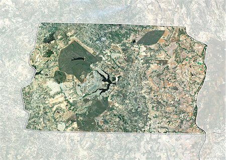
Satellite view of Brasilia and the Federal District , Brazil. This image was compiled from data acquired by LANDSAT 5 & 7 satellites.
Con derechos protegidos
-

Relief map of Brasilia and the Federal District , Brazil. This image was compiled from data acquired by LANDSAT 5 & 7 satellites combined with elevation data.
Con derechos protegidos
-
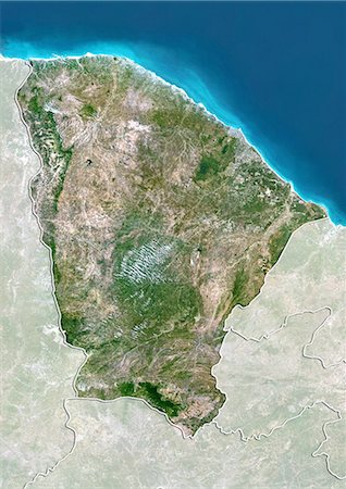
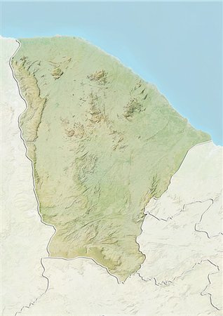
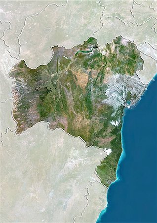
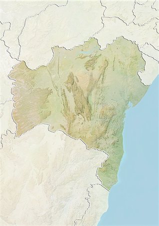
Satellite view of the State of Ceara, Brazil. This image was compiled from data acquired by LANDSAT 5 & 7 satellites.
Con derechos protegidos
-
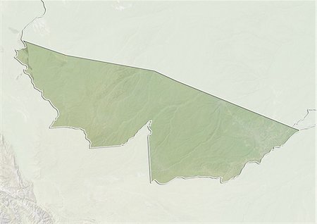
Relief map of the State of Ceara, Brazil. This image was compiled from data acquired by LANDSAT 5 & 7 satellites combined with elevation data.
Con derechos protegidos
-
Satellite view of the State of Bahia, Brazil. This image was compiled from data acquired by LANDSAT 5 & 7 satellites.
Con derechos protegidos
-
Relief map of the State of Bahia, Brazil. This image was compiled from data acquired by LANDSAT 5 & 7 satellites combined with elevation data.
Con derechos protegidos
-

Satellite view of the State of Amazonas, Brazil. This image was compiled from data acquired by LANDSAT 5 & 7 satellites.
Con derechos protegidos
-

Relief map of the State of Amazonas, Brazil. This image was compiled from data acquired by LANDSAT 5 & 7 satellites combined with elevation data.
Con derechos protegidos
-

Satellite view of the State of Amapa, Brazil. This image was compiled from data acquired by LANDSAT 5 & 7 satellites.
Con derechos protegidos
-

Relief map of the State of Amapa, Brazil. This image was compiled from data acquired by LANDSAT 5 & 7 satellites combined with elevation data.
Con derechos protegidos
-

Satellite view of the State of Alagoas, Brazil. This image was compiled from data acquired by LANDSAT 5 & 7 satellites.
Con derechos protegidos
-

Relief map of the State of Alagoas, Brazil. This image was compiled from data acquired by LANDSAT 5 & 7 satellites combined with elevation data.
Con derechos protegidos
-

Satellite view of the State of Acre, Brazil. This image was compiled from data acquired by LANDSAT 5 & 7 satellites.
Con derechos protegidos
-
Relief map of the State of Acre, Brazil. This image was compiled from data acquired by LANDSAT 5 & 7 satellites combined with elevation data.
Con derechos protegidos
-
-

-

-

-

-

-

-

-

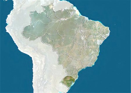
Brazil and the State of Santa Catarina, True Colour Satellite Image
Con derechos protegidos
-
-

-

-
-

-
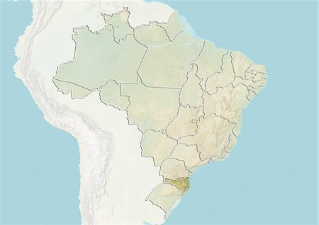
Brazil and the State of Rio Grande do Sul, True Colour Satellite Image
Con derechos protegidos
-

-

Brazil and the State of Rio Grande do Norte, True Colour Satellite Image
Con derechos protegidos
-

-

Brazil and the State of Rio de Janeiro, True Colour Satellite Image
Con derechos protegidos
-

-

-

-

Brazil and the State of Pernambuco, True Colour Satellite Image
Con derechos protegidos
-

-
-

-

-

-

-
-
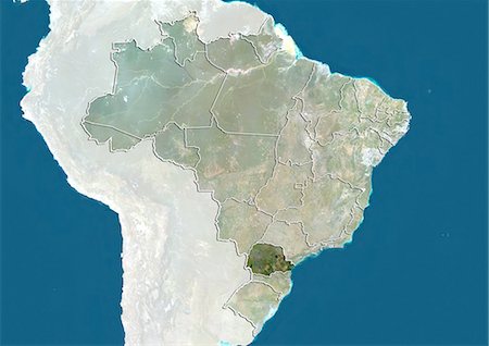
Brazil and the State of Mato Grosso do Sul, True Colour Satellite Image
Con derechos protegidos
-
-

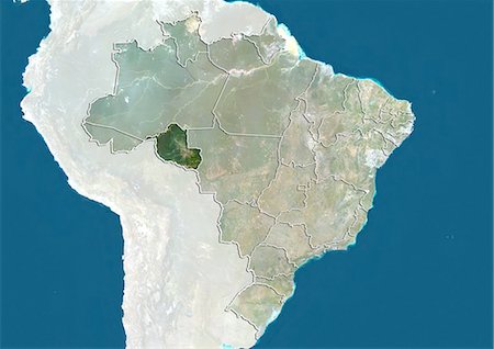
Brazil and the State of Mato Grosso, True Colour Satellite Image
Con derechos protegidos
-