-

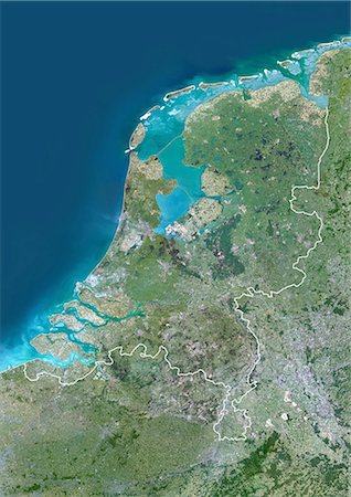
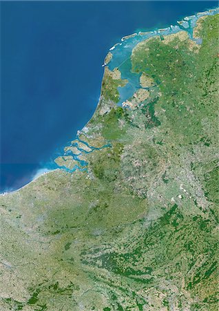
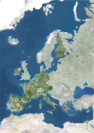
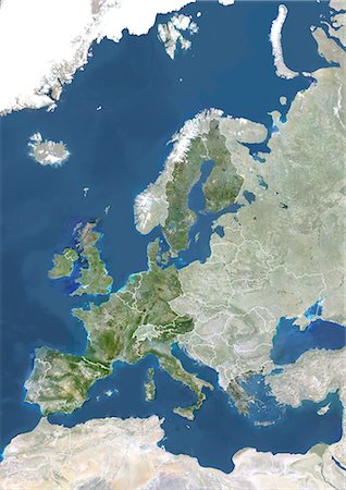
Netherlands, Europe, True Colour Satellite Image With Mask. Satellite view of the Netherlands (with mask). This image was compiled from data acquired by LANDSAT 5 & 7 satellites.
Con derechos protegidos
-

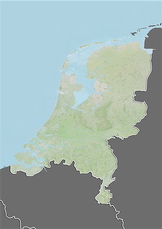
Netherlands, Europe, True Colour Satellite Image With Border And Mask. Satellite view of the Netherlands (with border and mask). This image was compiled from data acquired by LANDSAT 5 & 7 satellites.
Con derechos protegidos
-
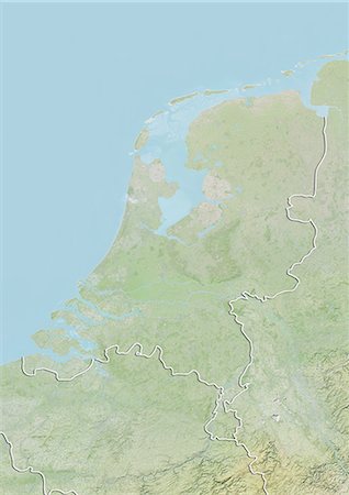
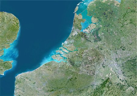
Netherlands, Europe, True Colour Satellite Image With Border. Satellite view of the Netherlands (with border). This image was compiled from data acquired by LANDSAT 5 & 7 satellites.
Con derechos protegidos
-

-

-
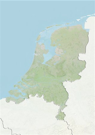
Relief map of Netherlands (with border and mask). This image was compiled from data acquired by landsat 5 & 7 satellites combined with elevation data.
Con derechos protegidos
-

-

-
-
-
-

-
-
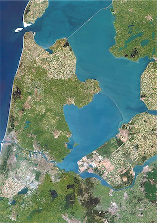
Polders, Netherlands, True Colour Satellite Image. Polders in the Netherlands, true colour satellite image. Polders are land reclaimed from the sea, using dikes and dunes, that are drained to expand the Dutch territory and for use as farmland. Image taken on 1 July 1994 using LANDSAT data.
Con derechos protegidos
-
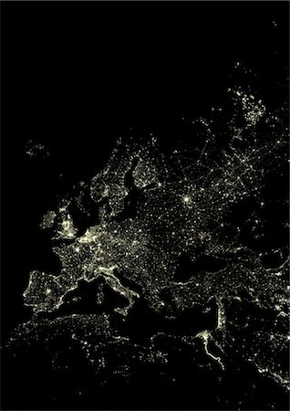
Western Europe At Night, Satellite Image. Lights of Western Europe at night from space. Coloured image derived from satellite data showing Western Europe at night. This image is a mosaic of frames made at night by US Defense Meteorological Satellite Program (DMSP).
Con derechos protegidos
-
Western Europe, True Colour Satellite Image. True colour satellite mosaic image of the whole of Europe and Scandinavia. The image used data from LANDSAT 5 & 7 satellites.
Con derechos protegidos
-
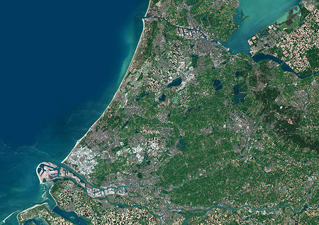
Color satellite image of Randstad, Netherlands. This megalopolis in the central-western Netherlands consists of the four largest Dutch cities, i.e. Amsterdam, Rotterdam, The Hague and Utrecht and their surrounding areas. Image collected on May 26, 2017 by Sentinel-2 satellites.
Con derechos protegidos
-

-

-

-
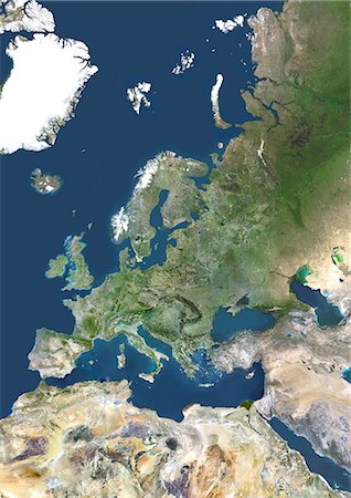
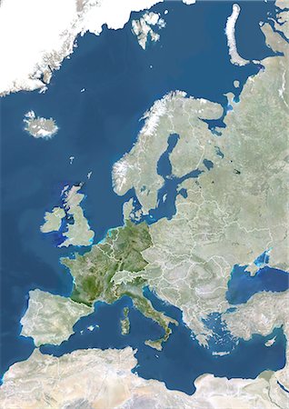
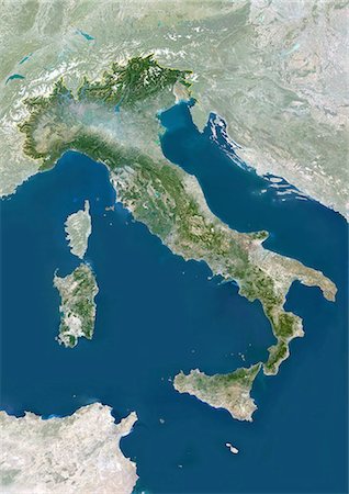
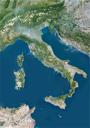
Eurozone In 2002, True Colour Satellite Image With Mask And Borders. True colour satellite image of the Eurozone in 2002, showing the 12 EU member states officially using the euro (Netherlands, Italy, Luxemburg, France, Belgium, Germany, Ireland, Greece, Spain, Portugal, Austria, Finland). This image in Lambert Conformal Conic projection was compiled from data acquired by LANDSAT 5 & 7 satellites.
Con derechos protegidos
-

Member States Of The European Union In 2007, True Colour Satellite Image With Mask And Borders. True colour satellite image of the European Union in 2007, showing the 27 member states. This image in Lambert Conformal Conic projection was compiled from data acquired by LANDSAT 5 & 7 satellites.
Con derechos protegidos
-

Member States Of The European Union In 2004, True Colour Satellite Image With Mask And Borders. True colour satellite image of the European Union in 2004, showing the 25 member states. This image in Lambert Conformal Conic projection was compiled from data acquired by LANDSAT 5 & 7 satellites.
Con derechos protegidos
-
Member States Of The European Union In 1995, True Colour Satellite Image With Mask And Borders. True colour satellite image of the European Union in 1995, showing the 15 member states. This image in Lambert Conformal Conic projection was compiled from data acquired by LANDSAT 5 & 7 satellites.
Con derechos protegidos
-

Member States Of The European Union In 1986, True Colour Satellite Image With Mask And Borders. True colour satellite image of the European Union in 1986, showing the 12 member states. This image in Lambert Conformal Conic projection was compiled from data acquired by LANDSAT 5 & 7 satellites.
Con derechos protegidos
-

Member States Of The European Union In 1981, True Colour Satellite Image With Mask And Borders. True colour satellite image of the European Union in 1981, showing the 10 member states. This image in Lambert Conformal Conic projection was compiled from data acquired by LANDSAT 5 & 7 satellites.
Con derechos protegidos
-

Member States Of The European Union In 1973, True Colour Satellite Image With Mask And Borders. True colour satellite image of the European Union in 1973, showing the 9 member states. This image in Lambert Conformal Conic projection was compiled from data acquired by LANDSAT 5 & 7 satellites.
Con derechos protegidos
-
Member States Of The European Union In 1957, True Colour Satellite Image With Mask And Borders. True colour satellite image of the European Union in 1957, showing the 6 member states. This image in Lambert Conformal Conic projection was compiled from data acquired by LANDSAT 5 & 7 satellites.
Con derechos protegidos
-

United Kingdom, Europe, True Colour Satellite Image With Mask. Satellite view of the United Kingdom (with mask). This image was compiled from data acquired by LANDSAT 5 & 7 satellites.
Con derechos protegidos
-

United Kingdom, Europe, True Colour Satellite Image With Border And Mask. Satellite view of the United Kingdom (with border and mask). This image was compiled from data acquired by LANDSAT 5 & 7 satellites.
Con derechos protegidos
-
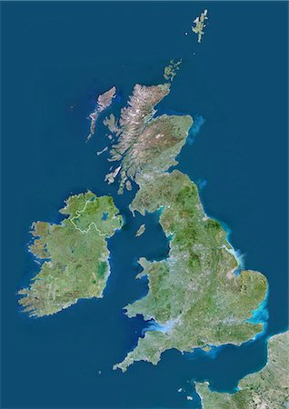
United Kingdom, Europe, True Colour Satellite Image With Border. Satellite view of Bulgaria (with border). This image was compiled from data acquired by LANDSAT 5 & 7 satellites.
Con derechos protegidos
-
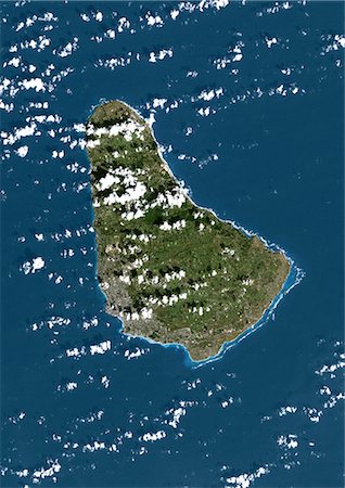
Barbados, True Colour Satellite Image. Barbados, true colour satellite image taken on 1 February 2002, by the LANDSAT 7 satellite.
Con derechos protegidos
-
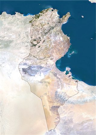
Tunisia, True Colour Satellite Image With Mask And Border. Tunisia, true colour satellite image with mask and border. North is at top. Around forty-five percent of the country is composed of the Sahara desert, with much of the remainder consisting of particularly fertile soil, with easily accessible coasts. This image was compiled from data acquired by LANDSAT 5 & 7 satellites.
Con derechos protegidos
-

Tunisia, True Colour Satellite Image With Border. Tunisia, true colour satellite image with border. North is at top. Around forty-five percent of the country is composed of the Sahara desert, with much of the remainder consisting of particularly fertile soil, with easily accessible coasts. This image was compiled from data acquired by LANDSAT 5 & 7 satellites.
Con derechos protegidos
-
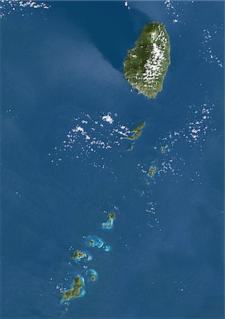
Saint Vincent And The Grenadines, True Colour Satellite Image. Saint Vincent and the Grenadines, true colour satellite image. The main island of Saint Vincent is at top. South is the Grenadines, a chain of smaller islands stretching south from Saint Vincent to Grenada. This image was taken on 4 November 2001, by the LANDSAT 7 satellite.
Con derechos protegidos
-
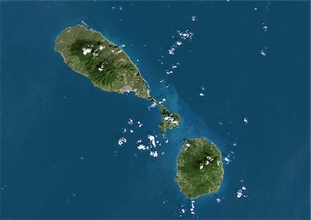
Saint Kits And Nevis, True Colour Satellite Image. Saint Kitts and Nevis, true colour satellite image. The main island (upper left) is Saint Kitts, with the capital city Basseterre located on its south coast. The smaller island of Nevis(bottom right) lies about 3 km southeast of Saint Kitts. This image was taken on 8 December 1999, by the LANDSAT 7 satellite.
Con derechos protegidos
-
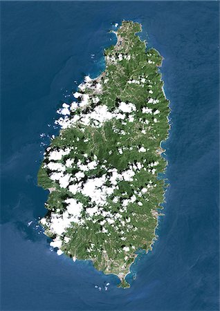
Saint Lucia, True Colour Satellite Image. Saint Lucia, true colour satellite image taken on 16 October 2000, by the LANDSAT 7 satellite.
Con derechos protegidos
-

Russia, True Colour Satellite Image With Mask And Border. Russia, true colour satellite image with mask and border. Composite image using data from LANDSAT 5 & 7satellites.
Con derechos protegidos
-

Russia, True Colour Satellite Image With Border. Russia, true colour satellite image with border. Composite image using data from LANDSAT 5 & 7satellites.
Con derechos protegidos
-

Russia, True Colour Satellite Image With Mask. Russia, true colour satellite image with mask. Composite image using data from LANDSAT 5 & 7satellites.
Con derechos protegidos
-

Russia, True Colour Satellite Image. Russia, true colour satellite image. Composite image using data from LANDSAT 5 & 7satellites.
Con derechos protegidos
-

Portugal, True Colour Satellite Image With Mask And Border. Portugal. True colour satellite image of Portugal with mask and border. North is at top. Lisbon (Lisboa), the capital of Portugal, lies on the north side of the northernmost inlet at lower left. The Atlantic Ocean is seen to the west. The image used data from LANDSAT 5 & 7 satellites.
Con derechos protegidos
-

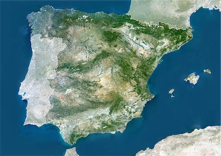
Portugal, True Colour Satellite Image With Border. Portugal. True colour satellite image of Portuga with border. North is at top. Part of Spain is also seen. Lisbon (Lisboa), the capital of Portugal, lies on the north side of the northernmost inlet at lower left. The Atlantic Ocean is seen to the west. The image used data from LANDSAT 5 & 7 satellites.
Con derechos protegidos
-

Puerto Rico And The Virgin Islands, True Colour Satellite Image. Puerto Rico and the Virgin Islands. True colour satellite image showing Puerto Rico (west) and the Virgin islands (east). Composite image using data from LANDSAT 5 & 7satellites.
Con derechos protegidos
-

Nauru, True Colour Satellite Image. Nauru. True colour satellite image of Nauru, an island nation in Micronesia in the South Pacific. This image was taken on 29 June 1999, by the LANDSAT 7 satellite.
Con derechos protegidos
-
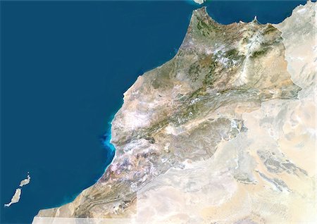
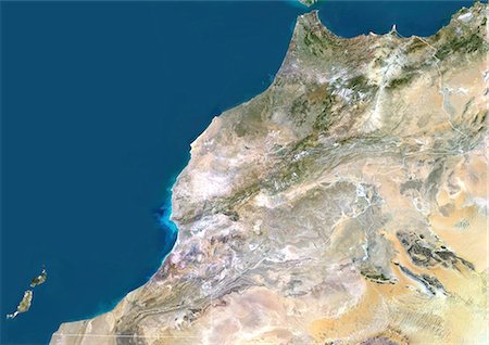
Morocco, True Colour Satellite Image With Mask And Border. Morocco. True colour satellite image of Morocco, with mask and border. The Strait of Gibraltar is at top center. The Mediterranean Sea is to the east of this strait, with the Atlantic Ocean to the west. This image was compiled from data acquired by LANDSAT 5 & 7 satellites.
Con derechos protegidos
-
Morocco, True Colour Satellite Image With Border. Morocco. True colour satellite image of Morocco, with border. The Strait of Gibraltar is at top center. The Mediterranean Sea is to the east of this strait, with the Atlantic Ocean to the west. This image was compiled from data acquired by LANDSAT 5 & 7 satellites.
Con derechos protegidos
-

-
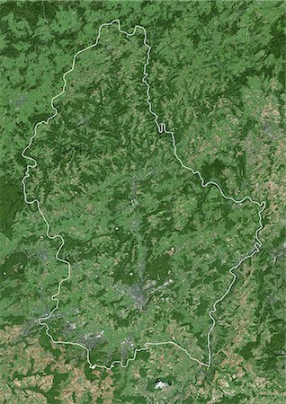
Luxembourg, True Colour Satellite Image With Border. Luxembourg. True colour satellite image of the Grand Duchy of Luxembourg with border. North is at top. Luxembourg City, Luxembourg's capital city, is at lower centre. Luxembourg is bordered by Germany to the east, France to the south and Belgium to the north and west. This image was taken on 11 September 2000, by the LANDSAT 7 satellite.
Con derechos protegidos
-

Lebanon, True Colour Satellite Image With Mask And Border. Lebanon, true colour satellite image with mask and border. This image was compiled from data acquired by LANDSAT 5 & 7 satellites.
Con derechos protegidos
-

Lebanon, True Colour Satellite Image With Border. Lebanon, true colour satellite image with border. This image was compiled from data acquired by LANDSAT 5 & 7 satellites.
Con derechos protegidos
-

Japan, True Colour Satellite Image With Mask. Japan, true colour satellite image with mask. Japan is an archipelago of islands in the northern Pacific Ocean. Japan's capital city, Tokyo (grey, right centre), is situated on Japan's main island, Honshu. Japan's second largest island, Hokkaido, lies to the north of Honshu. This image was compiled from data acquired by LANDSAT 5 & 7 satellites.
Con derechos protegidos
-

Japan, True Colour Satellite Image. Japan, true colour satellite image. Japan is an archipelago of islands in the northern Pacific Ocean. Japan's capital city, Tokyo (grey, right centre), is situated on Japan's main island, Honshu. Japan's second largest island, Hokkaido, lies to the north of Honshu. This image was compiled from data acquired by LANDSAT 5 & 7 satellites.
Con derechos protegidos
-
-
-

-

-
-

-
-

Solomon Islands, True Colour Satellite Image. Solomon Islands, true colour satellite image. This image was compiled from data acquired by LANDSAT 7 satellite.
Con derechos protegidos
-
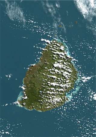
Mauritius, True Colour Satellite Image. Mauritius, true colour satellite image, taken on 19 August 1999, by the LANDSAT 7 satellite.
Con derechos protegidos
-
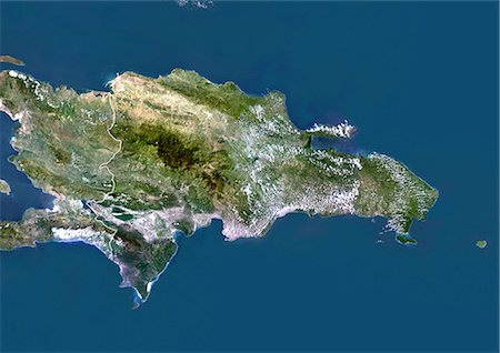
Dominican Republic, True Colour Satellite Image With Border. Dominican Republic, true colour satellite image with border. This image was compiled from data acquired by LANDSAT 5 & 7 satellites.
Con derechos protegidos
-
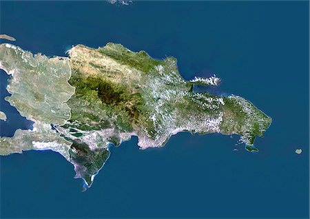
Dominican Republic, True Colour Satellite Image With Mask And Border. Dominican Republic, true colour satellite image with mask and border. This image was compiled from data acquired by LANDSAT 5 & 7 satellites.
Con derechos protegidos
-

Dominican Republic, True Colour Satellite Image With Mask. Dominican Republic, true colour satellite image with mask. This image was compiled from data acquired by LANDSAT 5 & 7 satellites.
Con derechos protegidos
-

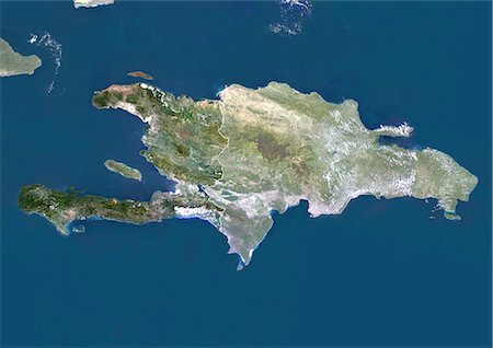
Haiti, True Colour Satellite Image With Border. Haiti, true colour satellite image with border. This image was compiled from data acquired by LANDSAT 5 & 7 satellites.
Con derechos protegidos
-

Haiti, True Colour Satellite Image With Mask And Border. Haiti, true colour satellite image with mask and border. This image was compiled from data acquired by LANDSAT 5 & 7 satellites.
Con derechos protegidos
-

Haiti, True Colour Satellite Image With Mask. Haiti, true colour satellite image with mask. This image was compiled from data acquired by LANDSAT 5 & 7 satellites.
Con derechos protegidos
-
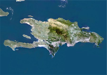
Haiti (With Mask And Border) And Dominican Republic, True Colour Satellite Image. Haiti (with mask and border) and Dominican Republic, true colour satellite image. This image was compiled from data acquired by LANDSAT 5 & 7 satellites.
Con derechos protegidos
-
Haiti And Dominican Republic (With Mask And Border), True Colour Satellite Image. Haiti and Dominican Republic (with mask and border), true colour satellite image. This image was compiled from data acquired by LANDSAT 5 & 7 satellites.
Con derechos protegidos
-

Haiti And Dominican Republic, True Colour Satellite Image With Border. Haiti and Dominican Republic, true colour satellite image with border. This image was compiled from data acquired by LANDSAT 5 & 7 satellites.
Con derechos protegidos
-

Haiti (With Mask) And Dominican Republic, True Colour Satellite Image With Mask. Haiti (with mask) and Dominican Republic, true colour satellite image. This image was compiled from data acquired by LANDSAT 5 & 7 satellites.
Con derechos protegidos
-

Haiti And Dominican Republic (With Mask), True Colour Satellite Image. Haiti and Dominican Republic (with mask), true colour satellite image. This image was compiled from data acquired by LANDSAT 5 & 7 satellites.
Con derechos protegidos
-
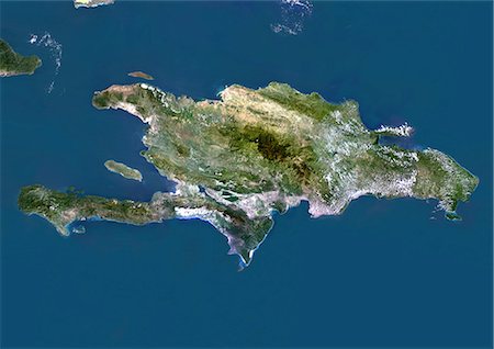
Haiti And Dominican Republic, True Colour Satellite Image. Haiti and Dominican Republic, true colour satellite image. This image was compiled from data acquired by LANDSAT 5 & 7 satellites.
Con derechos protegidos
-

Grenada, True Colour Satellite Image. Grenada, true colour satellite image. The image shows Grenada at bottom, and part of Saint Vincent and the Grenadines islands at top. Image taken on 4 November 2001, by the LANDSAT 7 satellite.
Con derechos protegidos
-

-
-
United States (Alaska Incl.), True Colour Satellite Image With Border And Mask. USA (Alaska incl.), true colour satellite image with border and mask. This image was compiled from data acquired by LANDSAT 5 & 7 satellites.
Con derechos protegidos
-

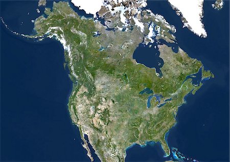
United States (Alaska Incl.), True Colour Satellite Image With Border. USA (Alaska incl.) and Canada, true colour satellite image. This image was compiled from data acquired by LANDSAT 5 & 7 satellites.
Con derechos protegidos
-

United States (Alaska Incl.), True Colour Satellite Image With Mask. USA (Alaska incl.), true colour satellite image with mask. This image was compiled from data acquired by LANDSAT 5 & 7 satellites.
Con derechos protegidos
-
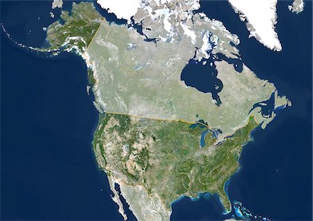
United States (Alaska Incl.) And Canada, True Colour Satellite Image. USA (Alaska incl.) and Canada, true colour satellite image. This image was compiled from data acquired by LANDSAT 5 & 7 satellites.
Con derechos protegidos
-
-

-
-

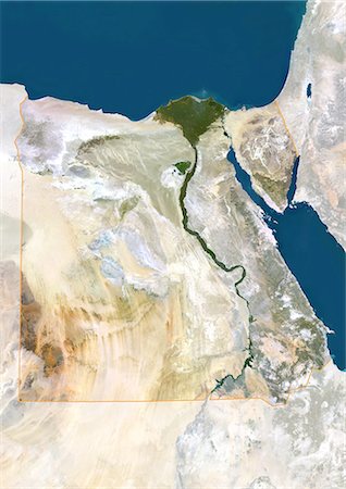
Egypt, True Colour Satellite Image With Border. Egypt, true colour satellite image with border. North is at top. In the center of the image is the Nile Delta, its lush vegetation following the path of the river. To the east of the Nile is the Gulf of Suez, which runs down the western side of the Sinai Peninsula. This image was compiled from data acquired by LANDSAT 5 & 7 satellites.
Con derechos protegidos
-

-

-
-

-

Antigua And Barbuda, True Colour Satellite Image. Antigua and Barbuda, true colour satellite image. Barbuda is at top. Antigua is at bottom center. This image was taken on 8 December 1999, by the LANDSAT 7 satellite.
Con derechos protegidos


