-

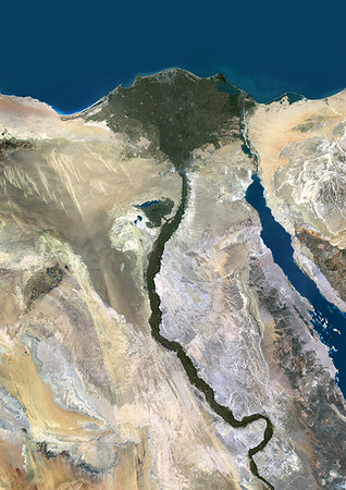
Nile Delta, Egypt, True Colour Satellite Image. True colour satellite image of the Nile Delta. It is formed in Northern Egypt where the Nile River spreads out and drains into the Mediterranean Sea. This swamp region has always been rich in fauna and flora, contrasting with the surrounding desert. Image taken on 23 August 2000 using LANDSAT data.
Con derechos protegidos
-
Color satellite image of the Nile River, Egypt. The Nile Delta is formed in Northern Egypt where the Nile River spreads out and drains into the Mediterranean Sea. Images collected on October 1, 2017 by Landsat 8 satellite.
Con derechos protegidos
-

Color satellite image of the Nile Delta. It is formed in Northern Egypt where the Nile River spreads out and drains into the Mediterranean Sea. Image collected on October 1, 2017 by Sentinel-2 satellites.
Con derechos protegidos
-
-

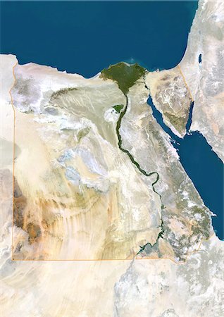
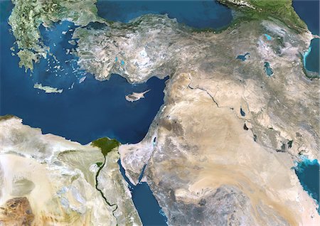
Egypt, True Colour Satellite Image With Border. Egypt, true colour satellite image with border. North is at top. In the center of the image is the Nile Delta, its lush vegetation following the path of the river. To the east of the Nile is the Gulf of Suez, which runs down the western side of the Sinai Peninsula. This image was compiled from data acquired by LANDSAT 5 & 7 satellites.
Con derechos protegidos
-
-

Assouan Dam And Lake Nasser, Egypt, True Colour Satellite Image. True colour satellite image of Assouan dam on the Nile river and the Lake Nasser in Egypt. Image taken on 15 November 1986 using LANDSAT data.
Con derechos protegidos
-

Egypt, True Colour Satellite Image With Mask. Egypt, true colour satellite image with mask. North is at top. In the center of the image is the Nile Delta, its lush vegetation following the path of the river. To the east of the Nile is the Gulf of Suez, which runs down the western side of the Sinai Peninsula. This image was compiled from data acquired by LANDSAT 5 & 7 satellites.
Con derechos protegidos
-

Cairo City, Egypt, In 2000, True Colour Satellite Image. True colour satellite image of Cairo City, the capital city of Egypt. Image taken on 11 November 2000 using LANDSAT data.
Con derechos protegidos
-
Cairo City, Egypt, In 1972, True Colour Satellite Image. True colour satellite image of Cairo City, the capital city of Egypt. Image taken on 31 August 1972 using LANDSAT data.
Con derechos protegidos
-
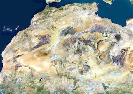
Sahara Desert, Africa, True Colour Satellite Image. Sahara desert, true colour satellite image. The Sahara is the world's largest hot desert, made of sand and volcanic mountains. Composite image using data from LANDSAT 5 & 7 satellites.
Con derechos protegidos
-

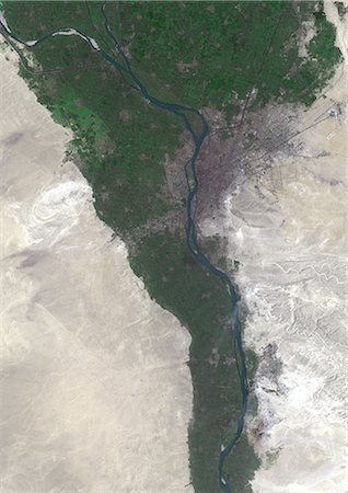
Cairo City, Egypt, True Colour Satellite Image. Cairo City, Egypt. True colour satellite image of Cairo City, the capital city of Egypt. Image taken on 11 September 2000 using LANDSAT 7 data.
Con derechos protegidos
-
-
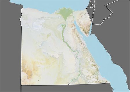
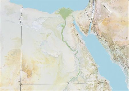
Relief map of Egypt (with border and mask). This image was compiled from data acquired by landsat 5 & 7 satellites combined with elevation data.
Con derechos protegidos
-

-

-
-

-
-
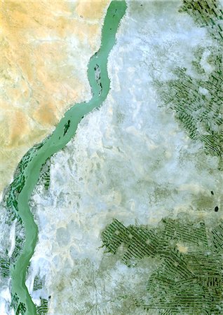
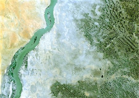
White Nile, Sudan, True Colour Satellite Image. White Nile, Sudan, true colour satellite image. Agriculture in a desertic area, on the plain of Jazira in Sudan, along the White Nile. Image taken on 21 February 2000 using LANDSAT data.
Con derechos protegidos
-

Mediterranean Area, True Colour Satellite Image. Mediterranean Sea. True colour satellite images showing the Mediterranean Sea. Points of interest include the Alps (just above centre, white), the Blakek Sea (centre right), and the Nile Delta (green, lower right). This image was compiled from data acquired by LANDSAT 5 & 7 satellites.
Con derechos protegidos
-

Colour satellite image of Cairo, Egypt. Image taken on December 16, 2013 with Landsat 8 data.
Con derechos protegidos
-

Color satellite image of Cairo, capital city of Egypt. Image collected on October 01, 2017 by Sentinel-2 satellites.
Con derechos protegidos
-

Satellite view of North Africa. This image was compiled from data acquired by Landsat 7 & 8 satellites.
Con derechos protegidos
-
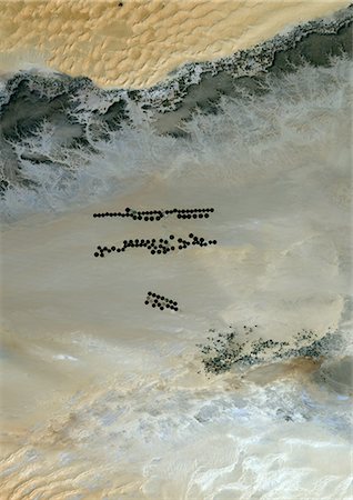
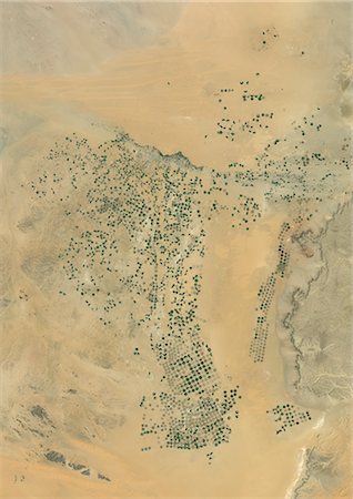
Agriculture In The Murzuq Desert In 2005, Libya, True Colour Satellite Image. True colour satellite image of agriculture in the northern Murzuq Desert in Libya. The Murzuq Desert is an erg desert, part of the Sahara desert, in southwestern Libya. Circular agricultural plots are visible on the image. Image taken on 11 March 2005, using LANDSAT 7 data.
Con derechos protegidos
-

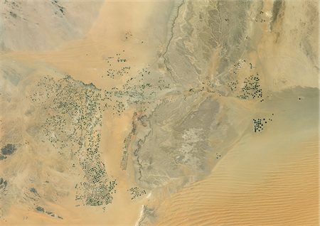
Agriculture In The Murzuq Desert In 2000, Libya, True Colour Satellite Image. True colour satellite image of agriculture in the northern Murzuq Desert in Libya. The Murzuq Desert is an erg desert, part of the Sahara desert, in southwestern Libya. Circular agricultural plots are visible on the image. Image taken on 8 November 2000, using LANDSAT 7 data.
Con derechos protegidos
-
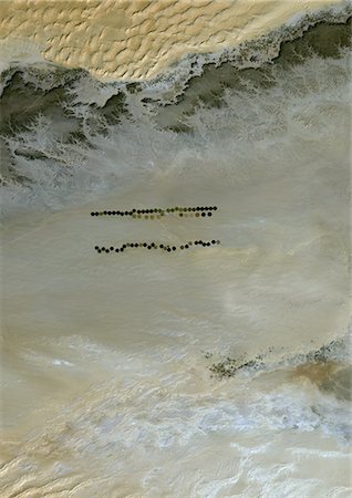
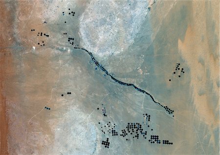
Agriculture In The Murzuq Desert In 1987, Libya, True Colour Satellite Image. True colour satellite image of agriculture in the northern Murzuq Desert in Libya. The Murzuq Desert is an erg desert, part of the Sahara desert, in southwestern Libya. Circular agricultural plots are visible on the image. Image taken on 13 January 1987, using LANDSAT 5 data.
Con derechos protegidos
-

Agriculture In The Libyan Desert, Libya, True Colour Satellite Image. True colour satellite image of agriculture in the Libyan desert in 2001, in the eastern part of Libya. Circular agricultural plots are visible on the image. Composite image using LANDSAT 7 data.
Con derechos protegidos
-

Agriculture In The Desert, City Of Tabuk In 2001, Saudi Arabia, True Colour Satellite Image. True colour satellite image of the city of Tabuk in 2001, in north western Saudi Arabia. Circular agricultural plots are visible on the image. Composite image using LANDSAT 7 data.
Con derechos protegidos
-

Agriculture In The Desert, City Of Tabuk In 1990, Saudi Arabia, True Colour Satellite Image. True colour satellite image of the city of Tabuk in 1990, in north western Saudi Arabia. Circular agricultural plots are visible on the image. Composite image using LANDSAT 5 data.
Con derechos protegidos
-
Agriculture In The Desert, South Part Of The Riyadh Province, Saudi Arabia, True Colour Satellite Image. True colour satellite image of agriculture in the desert in Saudi Arabia. The image shows the south part of the Riyadh Province, about 500 km south of Riyadh. Circular agricultural plots are visible on the image. Composite image from 2001, using LANDSAT 7 data.
Con derechos protegidos
-

Topographic Map of Al Sulail, South Part Of The Riyadh Province, Saudi Arabia
Con derechos protegidos
-
Agriculture In The Desert, South Part Of The Riyadh Province, Saudi Arabia, True Colour Satellite Image. True colour satellite image of agriculture in the desert in Saudi Arabia. The image shows the south part of the Riyadh Province, about 500 km south of Riyadh. Circular agricultural plots are visible on the image. Composite image from 2001, using LANDSAT 7 data.
Con derechos protegidos
-

Agriculture In The Desert In 2006, Saudi Arabia, True Colour Satellite Image. True colour satellite image of agriculture in the desert, about 250 km west of the Saudi capital, Riyadh. Circular agricultural plots are visible on the image. Composite image taken in 2006, using LANDSAT 5 data.
Con derechos protegidos
-
Agriculture In The Desert In 2001, Saudi Arabia, True Colour Satellite Image. True colour satellite image of agriculture in the desert, about 250 km west of the Saudi capital, Riyadh. Circular agricultural plots are visible on the image. Composite image taken in 2001, using LANDSAT 5 data.
Con derechos protegidos
-

Agriculture In The Desert In 1998, Saudi Arabia, True Colour Satellite Image. True colour satellite image of agriculture in the desert, about 250 km west of the Saudi capital, Riyadh. Circular agricultural plots are visible on the image. Composite image taken in 1998, using LANDSAT 5 data.
Con derechos protegidos
-

Agriculture In The Desert, Al-Qassim Province, Saudi Arabia, True Colour Satellite Image. True colour satellite image of agriculture in the desert, north of the Saudi cities of Buraydah and Unaizah (bottom right), in the Al-Qassim Province, Saudi Arabia. Circular agricultural plots are visible on the image. Composite image using LANDSAT 7 data.
Con derechos protegidos
-
Riyadh, Saudi Arabia , True Colour Satellite Image. True colour satellite image of Riyadh, the capital and largest city of Saudi Arabia. Circular agricultural plots are visible southeast of Riyadh. Composite image using LANDSAT 7 data.
Con derechos protegidos
-

Agriculture In The Desert, Riyadh Province, Saudi Arabia, True Colour Satellite Image. True colour satellite image of agriculture in the desert in the Riyadh Province, Saudi Arabia, about 250 km west of the Saudi capital, Riyadh. Circular agricultural plots are visible on the image. Composite image using LANDSAT 7 data.
Con derechos protegidos
-

Okavango Delta, Botswana, True Colour Satellite Image. True colour satellite image of the Okavango Delta located in Botswana. It is the world's largest inland delta. Composite image using LANDSAT 5 data.
Con derechos protegidos
-

Meteor Impact Crater In The Libyan Desert, Egypt, True Colour Satellite Image. True colour satellite image of an impact structure in the Libyan desert, Egypt. Image taken on 9 November 1986 using LANDSAT data.
Con derechos protegidos
-

Libyan Desert, Egypt, True Colour Satellite Image. True colour satellite image of the Egyptian part of the Libyan desert, made of both sand and rock ; sand dunes are stretched out by the winds. Composite of 2 images dated 11 September 1984 and 27 September 1987 using LANDSAT data.
Con derechos protegidos
-

-

-

Satellite view of Africa. This image was compiled from data acquired by Landsat 7 & 8 satellites.
Con derechos protegidos
-

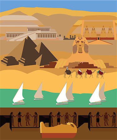
vector illustration of the sphinx on orange background
Super Valor sin royalties y Suscripción
-

-

-
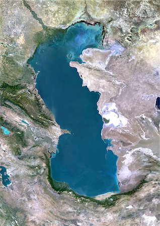
Caspian Sea, Asia, True Colour Satellite Image. True colour satellite image of the Caspian Sea in Asia. It is bounded by Iran, Russia, Kazakhstan, Turkmenistan and Azerbaijan. The Caspian Sea is the world's largest inland sea. Composite image using LANDSAT 5 data.
Con derechos protegidos
-

Syr Darya River Delta, Kazakhstan, True Colour Satellite Image. True colour satellite image of Syr Darya River Delta in Kazakhstan. The river irrigates the whole of Central Asia before emptying in the Aral Sea (top right and bottom left on the image). Composite image using LANDSAT 7 data.
Con derechos protegidos
-

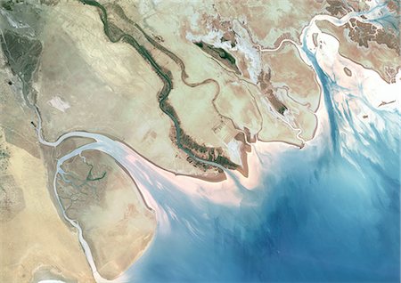
Kura River Delta, Azerbaijan, True Colour Satellite Image. True colour satellite image of the Kura River Delta in Azerbaijan. The Kura River flows into the Caspian Sea. Composite image using LANDSAT 7 data.
Con derechos protegidos
-
-

Satellite View of Saloum Delta And Gambia River, Western Africa
Con derechos protegidos
-

Ogooue River Delta, Gabon, True Colour Satellite Image. True colour satellite image of the Ogooué river delta, the principal river of Gabon in west central Africa. Composite image using LANDSAT 5 data.
Con derechos protegidos
-
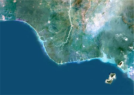
Niger River Delta, Nigeria, True Colour Satellite Image. True colour satellite image of the Niger River Delta in Nigeria, Africa. The city of Lagos, the second most populous city in Africa, is to be seen west of the Niger River Delta on the Atlantic coast in the Gulf of Guinea.Composite image using LANDSAT 5 data.
Con derechos protegidos
-

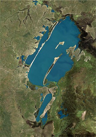
Lake Victoria, Africa, True Colour Satellite Image. True colour satellite image of Lake Victoria, one of the African Great Lakes. Lake Victoria is divided between three countries: Kenya, Uganda and Tanzania. Composite image using LANDSAT 5 data.
Con derechos protegidos
-

Lake Volta, Ghana, True Colour Satellite Image. True colour satellite image of Lake Volta, in Ghana. It is the largest reservoir by surface area in the world, and the fourth largest by volume. Composite image using LANDSAT 7 data.
Con derechos protegidos
-

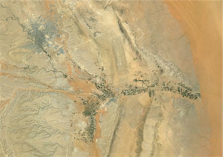
Koufra Oasis, Libya, True Colour Satellite Image. Koufra Oasis, Libya, true colour satellite image. The oasis of Koufra in the Libyan desert, East of the city of Al Jawf, with center-pivot irrigated fields. Image taken on 9 November 1996 using LANDSAT data.
Con derechos protegidos
-
-
-

View of the side of the River Nile with the Temple of Deir El Bahari in the background, Thebes, Egypt, North Africa, Africa
Con derechos protegidos
-

-
-

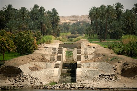
We take a closer look at life on Nile River on MAY 27, 2008, while having a felucca sailboat ride from Aswan to Elephantine Island and to a nubian village.
Super Valor sin royalties y Suscripción
-

-

-

-

On-line Map Marker With Pyramids Of Egypt. Smartphone App Classic Destination Tag In Geometric Design Isolated On White Background
Super Valor sin royalties y Suscripción
-

-
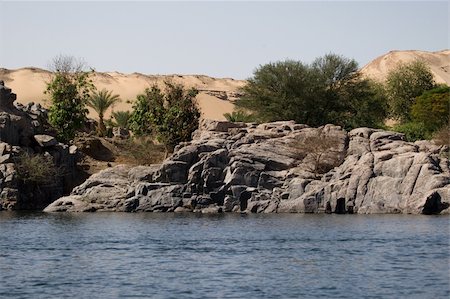
We take a closer look at life on Nile River on MAY 27, 2008, while having a felucca sailboat ride from Aswan to Elephantine Island and to a nubian village.
Super Valor sin royalties y Suscripción
-
Lake Bangweulu, Zambia, True Colour Satellite Image. True colour satellite image of Lake Bangweulu situated in the upper Congo River basin in Zambia, Africa. Part of the Bangweulu Swamps are at the bottom right corner of the image. Composite image from May 2002 using LANDSAT 7 data.
Con derechos protegidos
-

Lake Tanganyika, Africa, True Colour Satellite Image. True colour satellite image of Lake Tanganyika, an African Great Lake divided between four countries : Burundi, Democratic Republic of the Congo (DRC), Tanzania and Zambia. Composite image using LANDSAT 5 data.
Con derechos protegidos
-
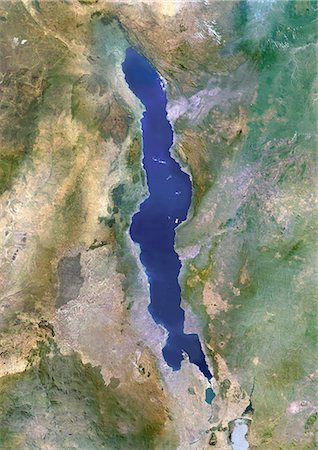
Lake Malawi, Africa, True Colour Satellite Image. True colour satellite image of Lake Malawi, an African Great Lake situated between Malawi, Mozambique, and Tanzania. Composite image using LANDSAT 5 data.
Con derechos protegidos
-

Europe At Night With Cloud Coverage, True Colour Satellite Image. True colour satellite image of Europe at night with cloud coverage. This image in Lambert Conformal Conic projection was compiled from data acquired by LANDSAT 5 & 7 satellites.
Con derechos protegidos
-
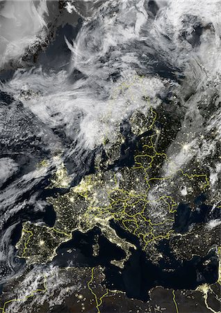
Europe At Night With Country Borders And Cloud Coverage, True Colour Satellite Image. True colour satellite image of Europe at night with country borders and cloud coverage. This image in Lambert Conformal Conic projection was compiled from data acquired by LANDSAT 5 & 7 satellites.
Con derechos protegidos
-

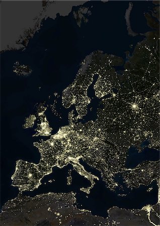
Europe At Night With Country Borders, True Colour Satellite Image. True colour satellite image of Europe at night with country borders. This image in Lambert Conformal Conic projection was compiled from data acquired by LANDSAT 5 & 7 satellites.
Con derechos protegidos
-
Europe At Night, True Colour Satellite Image. True colour satellite image of Europe at night. This image in Lambert Conformal Conic projection was compiled from data acquired by LANDSAT 5 & 7 satellites.
Con derechos protegidos
-

Europe With Cloud Coverage, True Colour Satellite Image. True colour satellite image of Europe with cloud coverage. This image in Lambert Conformal Conic projection was compiled from data acquired by LANDSAT 5 & 7 satellites.
Con derechos protegidos
-
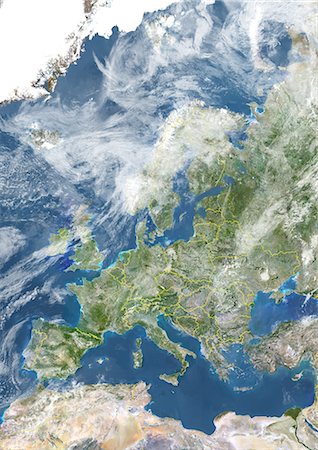
Europe With Country Borders And Cloud Coverage, True Colour Satellite Image. True colour satellite image of Europe with country borders and cloud coverage. This image in Lambert Conformal Conic projection was compiled from data acquired by LANDSAT 5 & 7 satellites.
Con derechos protegidos
-

Europe With Country Borders And Major Rivers, True Colour Satellite Image. True colour satellite image of Europe with country borders and major rivers. This image in Lambert Conformal Conic projection was compiled from data acquired by LANDSAT 5 & 7 satellites.
Con derechos protegidos
-
Europe With Country Borders, True Colour Satellite Image. True colour satellite image of Europe with country borders. This image in Lambert Conformal Conic projection was compiled from data acquired by LANDSAT 5 & 7 satellites.
Con derechos protegidos
-

Europe With Major Rivers, True Colour Satellite Image. True colour satellite image of Europe with major rivers. This image in Lambert Conformal Conic projection was compiled from data acquired by LANDSAT 5 & 7 satellites.
Con derechos protegidos
-

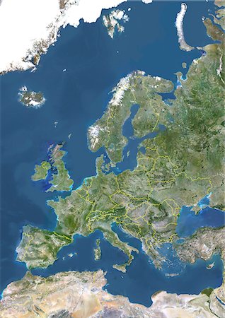
Europe, True Colour Satellite Image. True colour satellite image of Europe. This image in Lambert Conformal Conic projection was compiled from data acquired by LANDSAT 5 & 7 satellites.
Con derechos protegidos
-

Zimbabwe, Africa, True Colour Satellite Image With Mask. Satellite view of Zimbabwe (with mask). This image was compiled from data acquired by LANDSAT 5 & 7 satellites.
Con derechos protegidos
-

Zambia, Africa, True Colour Satellite Image With Mask. Satellite view of Zambia (with mask). This image was compiled from data acquired by LANDSAT 5 & 7 satellites.
Con derechos protegidos
-

Chad, Africa, True Colour Satellite Image With Mask. Satellite view of Chad (with mask). This image was compiled from data acquired by LANDSAT 5 & 7 satellites.
Con derechos protegidos
-

Sudan, Africa, True Colour Satellite Image With Mask. Satellite view of Sudan (with mask). This image was compiled from data acquired by LANDSAT 5 & 7 satellites.
Con derechos protegidos
-
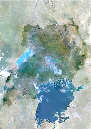
Uganda, Africa, True Colour Satellite Image With Mask. Satellite view of Uganda (with mask). This image was compiled from data acquired by LANDSAT 5 & 7 satellites.
Con derechos protegidos
-

Niger, Africa, True Colour Satellite Image With Mask. Satellite view of Niger (with mask). This image was compiled from data acquired by LANDSAT 5 & 7 satellites.
Con derechos protegidos
-

Mauritania, Africa, True Colour Satellite Image With Mask. Satellite view of Mauritania (with border and mask). This image was compiled from data acquired by LANDSAT 5 & 7 satellites.
Con derechos protegidos


