-
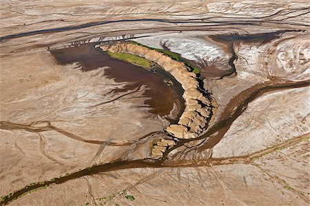
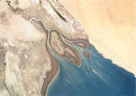
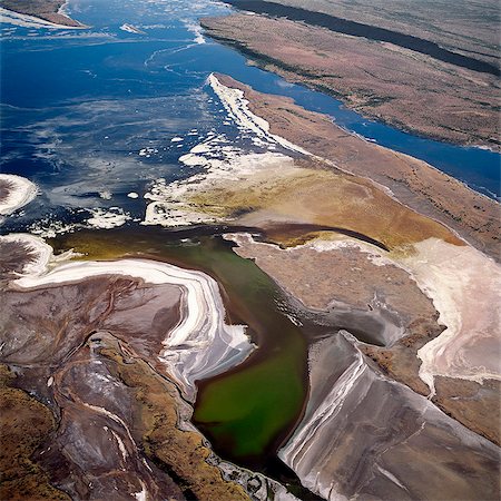
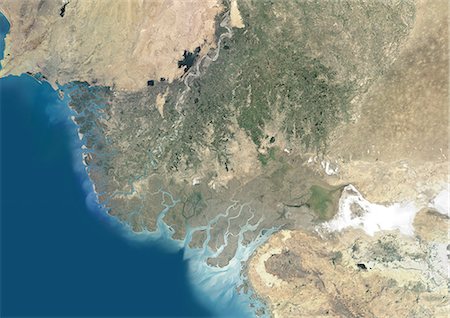
A part of the flood plain of the highly alkaline Suguta River which meanders through the low-lying, inhospitable Suguta Valley.
Con derechos protegidos
-
-

Woman wearing ao dai dress in boat, Can Tho, Mekong Delta, Vietnam, Indochina, Southeast Asia, Asia
Con derechos protegidos
-
-
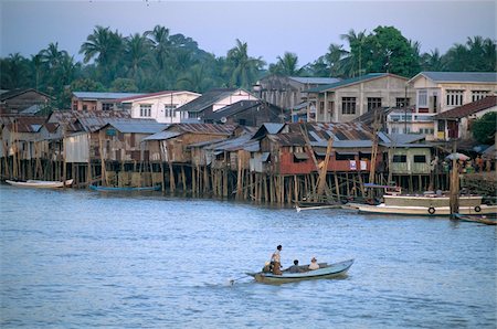
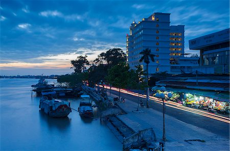
View of Can Tho River at dusk, Can Tho, Mekong Delta, Vietnam, Indochina, Southeast Asia, Asia
Con derechos protegidos
-
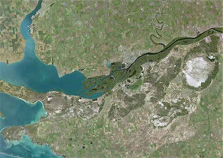
Colorado River Delta, Mexico, True Colour Satellite Image. True colour satellite image of the Colorado River Delta, Mexico. The Colorado River flows into the Gulf of California. Isla Montague is the large island in the center of the image. Composite image using LANDSAT 7 data.
Con derechos protegidos
-
-
-
-

-

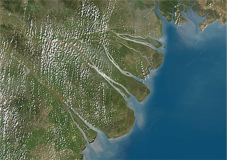
Mahanadi River Delta, India, True Colour Satellite Image. True colour satellite image of the Mahanadi River Delta in India. The Mahanadi River flows into the Gulf of Bengal. Composite image using LANDSAT 7 data.
Con derechos protegidos
-
-
Aerial view of Manzanita River delta at low tide, East Behm Canal, Misty Fiords National Monument Wilderness, Southeast, Alaska
Con derechos protegidos
-

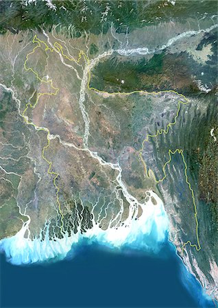
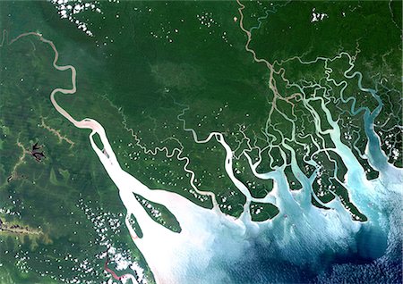
Ganges Delta, India And Bangladesh, True Colour Satellite Image. True colour satellite image of the Ganges River that forms an extensive delta where it empties into the Bay of Bengal. The delta is largely covered with a swamp forest known as the Sunderbans, which is home to the Royal Bengal Tiger. Image taken on 3 January 1989 using LANDSAT data.
Con derechos protegidos
-
Orinoco Delta, Venezuela, True Colour Satellite Image. True colour satellite image of the Orinoco Delta in eastern Venezuela, The Orinoco river flows into the Atlantic ocean. At top is the island of Trinidad in the Caribbean sea. Composite image using LANDSAT 5 data.
Con derechos protegidos
-

-
Bangladesh, Asia, True Colour Satellite Image With Border. Satellite view of Bangladesh (with border). This image was compiled from data acquired by LANDSAT 5 & 7 satellites.
Con derechos protegidos
-
-

-
Mekong Delta, Vietnam, True Colour Satellite Image. True colour satellite image of the Mekong Delta in Vietnam. The Mekong delta region encompasses a large portion of southeastern Vietnam. The Mekong River empties into the South China Sea. Composite image using LANDSAT 7 data.
Con derechos protegidos
-

Ayeyarwaddy (Irrawaddy) river delta, Ayeyarwaddy Division, Myanmar (Burma), Asia
Con derechos protegidos
-

Red River Delta, Vietnam, True Colour Satellite Image. True colour satellite image of the Red River Delta in Vietnam. The Red River flows through northern Vietnam to the Gulf of Tonkin. Composite image using LANDSAT 7 data.
Con derechos protegidos
-
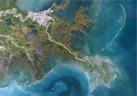
Niger River Delta, Nigeria, True Colour Satellite Image. True colour satellite image of the Niger River Delta in Nigeria, Africa. The city of Lagos, the second most populous city in Africa, is to be seen west of the Niger River Delta on the Atlantic coast in the Gulf of Guinea.Composite image using LANDSAT 5 data.
Con derechos protegidos
-

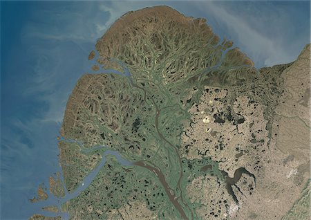
Mackenzie River Delta, Canada, True Colour Satellite Image. True colour satellite image of the Mackenzie River Delta. The Mackenzie River originates in Great Slave Lake, in the Northwest Territories (Canada), and flows north into the Arctic Ocean. Composite image using LANDSAT 7 data.
Con derechos protegidos
-

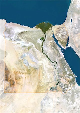
Nile Delta, Egypt, True Colour Satellite Image. True colour satellite image of the Nile Delta. It is formed in Northern Egypt where the Nile River spreads out and drains into the Mediterranean Sea. This swamp region has always been rich in fauna and flora, contrasting with the surrounding desert. Image taken on 23 August 2000 using LANDSAT data.
Con derechos protegidos
-

Kaveri River Delta, India, True Colour Satellite Image. True colour satellite image of the Kaveri River Delta in India. The Kaveri River empties into the Gulf of Bengal. Composite image using LANDSAT 7 data.
Con derechos protegidos
-

-
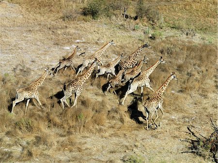
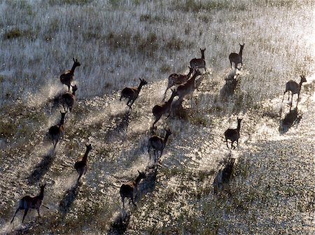
A herd of giraffes cross a dry flood plain in the Okavango Delta.
Con derechos protegidos
-
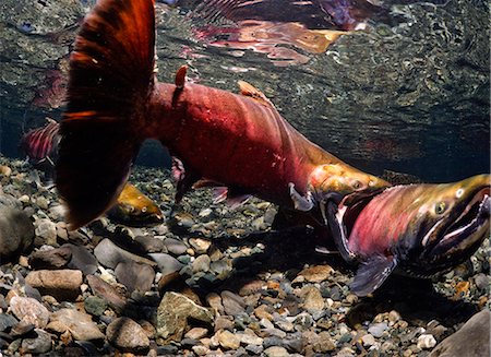
Male coho aggressively compete for females in Power Creek, Copper River Delta near Cordova and Prince William Sound, Southcentral Alaska
Con derechos protegidos
-
-

Egypt, True Colour Satellite Image With Border. Egypt, true colour satellite image with border. North is at top. In the center of the image is the Nile Delta, its lush vegetation following the path of the river. To the east of the Nile is the Gulf of Suez, which runs down the western side of the Sinai Peninsula. This image was compiled from data acquired by LANDSAT 5 & 7 satellites.
Con derechos protegidos
-

-

Bangladesh, Asia, True Colour Satellite Image With Mask. Satellite view of Bangladesh (with mask). This image was compiled from data acquired by LANDSAT 5 & 7 satellites.
Con derechos protegidos
-

Syr Darya River Delta, Kazakhstan, True Colour Satellite Image. True colour satellite image of Syr Darya River Delta in Kazakhstan. The river irrigates the whole of Central Asia before emptying in the Aral Sea (top right and bottom left on the image). Composite image using LANDSAT 7 data.
Con derechos protegidos
-
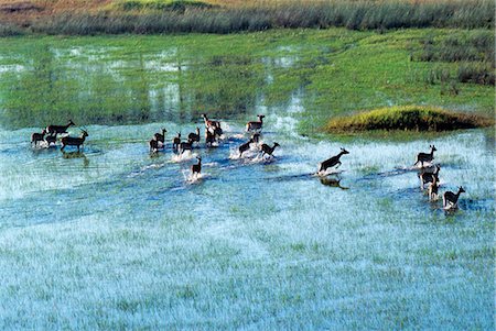
Red Lechwe run across a shallow flooded area of the Okavango River in the Okavango Delta of northwest Botswana. These heavily-built antelopes inhabit swamps and shallow floodplains for which their splayed,elongated hooves are ideally suited.
Con derechos protegidos
-
-
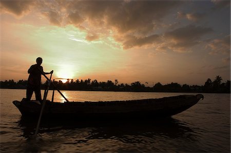
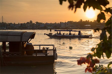
Sunrise, boats on the Mekong Delta, Cantho, Southern Vietnam, Southeast Asia, Asia
Con derechos protegidos
-

Ogooue River Delta, Gabon, True Colour Satellite Image. True colour satellite image of the Ogooué river delta, the principal river of Gabon in west central Africa. Composite image using LANDSAT 5 data.
Con derechos protegidos
-
-

Two large crocodiles bask in the sun beside a tributary of the Okavango River in the Okavango Delta of northwest Botswana.
Con derechos protegidos
-
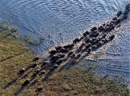
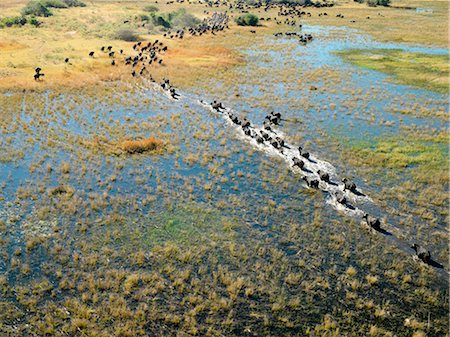
A large herd of buffalos cross a tributary of the Okavango River in the Okavango Delta of northwest Botswana.
Con derechos protegidos
-
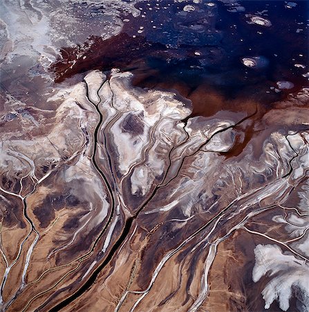
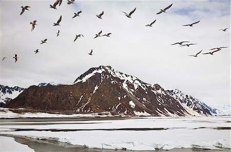
The Uaso Nyiru delta from the air. This freshwater river flows through southern Kenya and enters the northern end of Lake Natron only to become alkaline in the closed basin of this Tanzanian Rift Valley lake.
Con derechos protegidos
-

Ayeyarwaddy (Irrawaddy) river delta, Ayeyarwaddy Division, Myanmar (Burma), Asia
Con derechos protegidos
-

-
A section of the Uaso Nyiru delta from the air. This freshwater river flows through southern Kenya and enters the northern end of Tanzania's Lake Natron only to become alkaline in the intense heat of this closed basin Rift Valley lake.
Con derechos protegidos
-
Boats on Ben Tre River at sunset, Ben Tre, Mekong Delta, Vietnam, Indochina, Southeast Asia, Asia
Con derechos protegidos
-
-
-
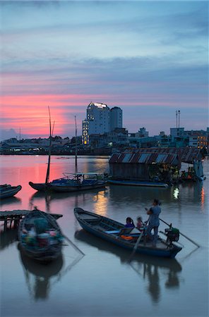
Boats on Can Tho River at sunset, Can Tho, Mekong Delta, Vietnam, Indochina, Southeast Asia, Asia
Con derechos protegidos
-
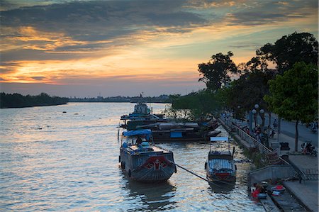
Boats on Ben Tre River at sunset, Ben Tre, Mekong Delta, Vietnam, Indochina, Southeast Asia, Asia
Con derechos protegidos
-

-
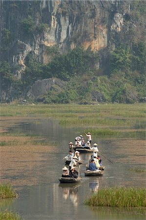
Punting boats on delta river, limestone mountain scenery, Van Long, Ninh Binh, south of Hanoi, North Vietnam, Southeast Asia, Asia
Con derechos protegidos
-

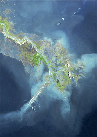
Irrawaddy Delta, Myanmar, True Colour Satellite Image. True colour satellite image of Irrawaddy Delta in Myanmar. The Irrawaddy River flows into the Bay of Bengal and Andaman Sea. On 2 May 2008, the delta suffered a major disaster, devastated by Cyclone Nargis. Composite image using LANDSAT 7 data.
Con derechos protegidos
-
-
Dnieper River Delta, Ukraine, True Colour Satellite Image. True colour satellite image of Dnieper River Delta in Ukraine. The Dnieper River flows into the Black Sea. Composite image using LANDSAT 7 data.
Con derechos protegidos
-
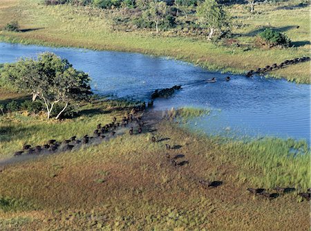
A large herd of buffalos cross a tributary of the Okavango River in the Okavango Delta of northwest Botswana.
Con derechos protegidos
-

Boats on Can Tho River, Can Tho, Mekong Delta, Vietnam, Indochina, Southeast Asia, Asia
Con derechos protegidos
-
Boats on Can Tho River at dawn, Can Tho, Mekong Delta, Vietnam, Indochina, Southeast Asia, Asia
Con derechos protegidos
-

Okavango Delta, Botswana, True Colour Satellite Image. True colour satellite image of the Okavango Delta located in Botswana. It is the world's largest inland delta. Composite image using LANDSAT 5 data.
Con derechos protegidos
-

-
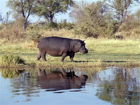
A hippo on the bank of the Kwai River in the northeast corner of the Moremi Game Reserve.
Con derechos protegidos
-

Punting boats on delta river, limestone mountain scenery, Van Long, Ninh Binh, south of Hanoi, North Vietnam, Southeast Asia, Asia
Con derechos protegidos
-
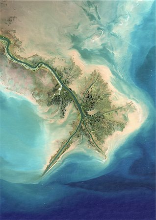
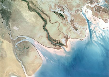
Indus Delta, Pakistan, True Colour Satellite Image. True colour satellite image of the Indus Delta in Pakistan. The Indus River flows into the Arabian Sea near Pakistan's port city of Karachi (top left on the image). The city of Hyderabad, located on the east bank of the Indus River, is on the top centre of the image. India is southeast of the Indus delta. Composite image using LANDSAT 7 data.
Con derechos protegidos
-
Along Tsiribihina, a river flowing from Madagascar in the Mozambique Channel by a delta, Madagascar, Indian Ocean, Africa
Con derechos protegidos
-
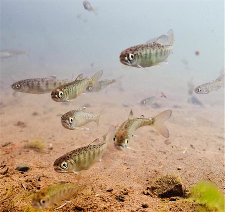
Underwater view of coho salmon (Oncorhynchus kisutch, Salmonidae) fry prior to smolting in the Eyak River (outlet of Eyak Lake) near Cordova, Copper River Delta, Southcentral Alaska, Spring
Con derechos protegidos
-

-

Lush vegetation in Okavango Delta, Moremi Game Reserve, Okavango Delta, Botswana, Africa
Con derechos protegidos
-

Boat on the Mekong Delta, Cantho, Southern Vietnam, Southeast Asia, Asia
Con derechos protegidos
-

A herd of elephants waters along the Kwai River on the northeast corner of the Moremi Game Reserve.
Con derechos protegidos
-

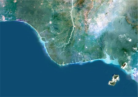
Satellite View of Saloum Delta And Gambia River, Western Africa
Con derechos protegidos
-

Aerial view of great white pelicans (Pelecanus onocrotalus), Okavango Delta, Botswana, Africa
Sin royalties Premium
-
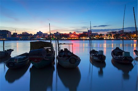
Boats on Can Tho River at sunset, Can Tho, Mekong Delta, Vietnam, Indochina, Southeast Asia, Asia
Con derechos protegidos
-

Boats on Ben Tre River at sunset, Ben Tre, Mekong Delta, Vietnam, Indochina, Southeast Asia, Asia
Con derechos protegidos
-

A herd of elephants waters along the Kwai River on the northeast corner of the Moremi Game Reserve.
Con derechos protegidos
-
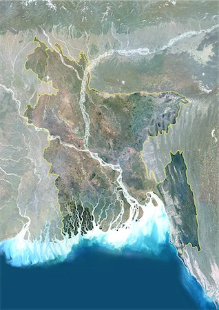
Bangladesh, Asia, True Colour Satellite Image With Border And Mask. Satellite view of Bangladesh (with border and mask). This image was compiled from data acquired by LANDSAT 5 & 7 satellites.
Con derechos protegidos
-

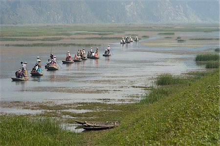
View of Tha Ton and Kok River, Chiang Mai Province, Thailand, Southeast Asia, Asia
Con derechos protegidos
-

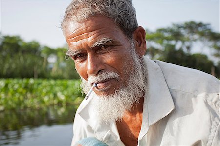
A tourist sits atop a pinasse (motorised riverboat) as it makes it way along the Niger River between Mopti and the port of Korioume at Timbuktu
Con derechos protegidos
-
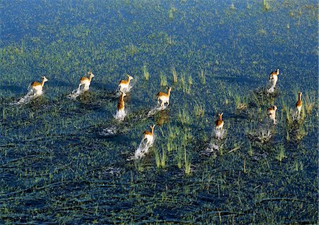
A small herd of Red Lechwe rushes across a shallow floodplain of the Okavango River in the Okavango Delta of northwest Botswana.These heavily built antelopes inhabit swamps and shallow floodplains for which their splayed, elongated hooves are ideally suited.
Con derechos protegidos
-
Punting boats on delta river, Van Long, Ninh Binh, south of Hanoi, North Vietnam, Southeast Asia, Asia
Con derechos protegidos
-

A small herd of Red Lechwe graze on high land surrounded by a floodplain of the Okavango River in the Okavango Delta of northwest Botswana.These heavily built antelopes inhabit swamps and shallow floodplains for which their splayed, elongated hooves are ideally suited.
Con derechos protegidos
-
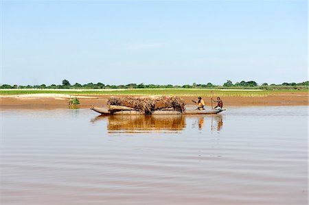
Jessore, Bangladesh. A traditional boatman transports goods on the tributaries of the Ganges-Brahmaputra delta.
Con derechos protegidos
-
Seagulls flying over the Copper River in search of Eulachon in the early spring during break-up, Chugach Mountains, Copper River Delta, Southcentral Alaska, Spring
Con derechos protegidos
-
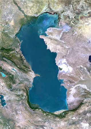
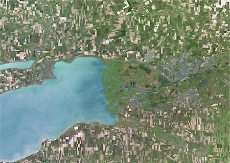
Caspian Sea, Asia, True Colour Satellite Image. True colour satellite image of the Caspian Sea in Asia. It is bounded by Iran, Russia, Kazakhstan, Turkmenistan and Azerbaijan. The Caspian Sea is the world's largest inland sea. Composite image using LANDSAT 5 data.
Con derechos protegidos
-
Yukon River Delta, Alaska, Usa, True Colour Satellite Image. True colour satellite image of Yukon River Delta in Alaska, United States. The Yukon river empties into the Bering Sea at the Yukon-Kuskokwim Delta. Composite image using LANDSAT 7 data.
Con derechos protegidos
-
Red Lechwe rush across a shallow tributary of the Okavango River in the Okavango Delta of northwest Botswana.These heavily built antelopes inhabit swamps and shallow floodplains for which their splayed, elongated hooves are ideally suited.
Con derechos protegidos
-
-
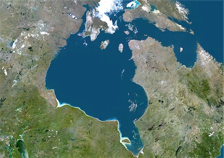
Hudson Bay, Canada, True Colour Satellite Image. True colour satellite image of Hudson Bay, a large body of water in northeastern Canada. A smaller offshoot of the bay, James Bay, lies to the south. North of Hudson Bay is Southampton island and westnorth is Baffin island. One group of islands in the southeast of the bay is the Belcher Islands. Composite image using LANDSAT 5 data.
Con derechos protegidos
-
-

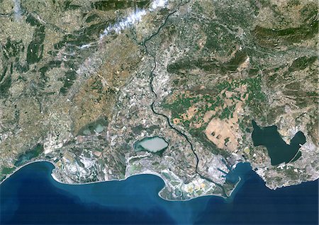
Kura River Delta, Azerbaijan, True Colour Satellite Image. True colour satellite image of the Kura River Delta in Azerbaijan. The Kura River flows into the Caspian Sea. Composite image using LANDSAT 7 data.
Con derechos protegidos
-
Don River Delta, Russia, True Colour Satellite Image. True colour satellite image of the Don River Delta in Russia. The Don River flows into the Sea of Azov. Composite image using LANDSAT 7 data.
Con derechos protegidos


