-

-
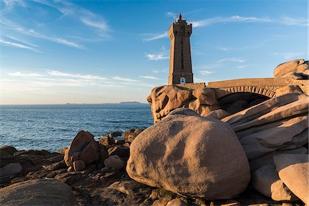
Ploumanach lighthouse. Perros-Guirec, Côtes-d'Armor, Brittany, France.
Con derechos protegidos
-
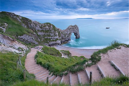
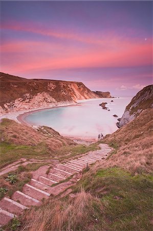
Steps leading down to Durdle Door on the Jurassic Coast, UNESCO World Heritage Site, Dorset, England, United Kingdom, Europe
Con derechos protegidos
-

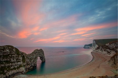
Durdle Door, Lulworth Cove, Jurassic Coast, UNESCO World Heritage Site, Dorset, England, United Kingdom, Europe
Sin royalties Premium
-
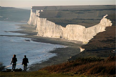
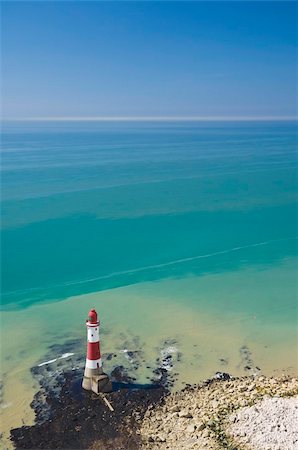
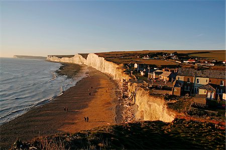
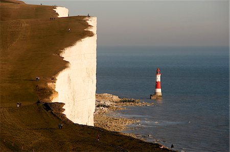
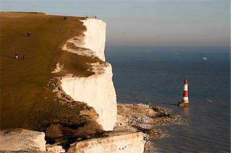
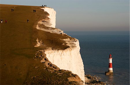
England,East Sussex,Beachy Head. Beachy Head is a chalk headland on the south coast of England,close to the town of Eastbourne. The cliff there is the highest chalk sea cliff in Britain,rising to 162 m (530 ft) above sea level. The peak allows views of the south east coast from Dungeness to the east,to Selsey Bill in the west.
Con derechos protegidos
-

Old rickety white wooden label covered in pebbles and two folding chairs on a shingle beach by the ocean.
Sin royalties Premium
-

Durdle Door, Lulworth Cove, Jurassic Coast, UNESCO World Heritage Site, Dorset, England, United Kingdom, Europe
Sin royalties Premium
-
Durdle Door, Lulworth Cove, Jurassic Coast, UNESCO World Heritage Site, Dorset, England, United Kingdom, Europe
Sin royalties Premium
-

Durdle Door, Lulworth Cove, Jurassic Coast, UNESCO World Heritage Site, Dorset, England, United Kingdom, Europe
Sin royalties Premium
-

-
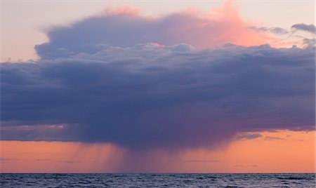
Heavy rainclouds at sunset over the English Channel, viewed from the Dorset Coast, Dorset, England, United Kingdom, Europe
Con derechos protegidos
-

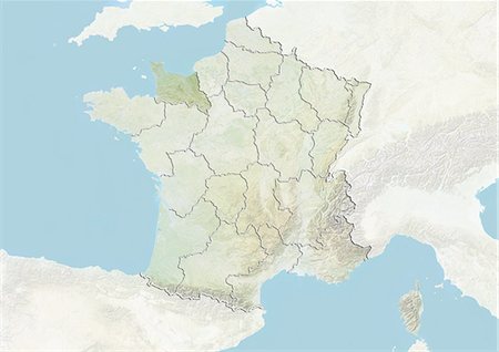
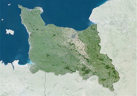
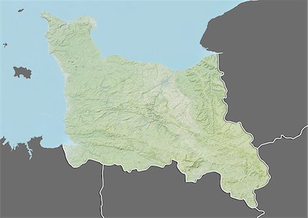
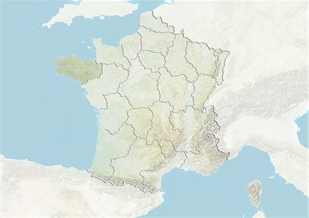
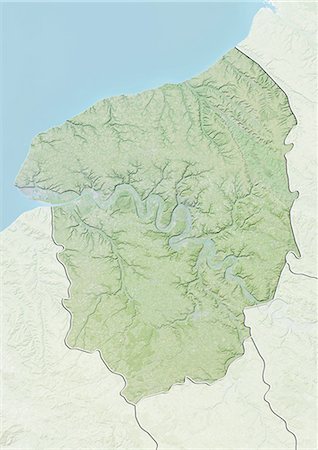
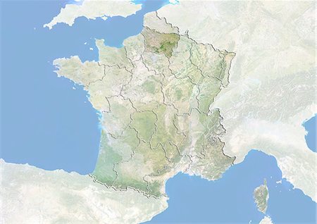
Relief map of Lower Normandy, France. This image was compiled from data acquired by LANDSAT 5 & 7 satellites combined with elevation data.
Con derechos protegidos
-

Man Of War Cove on the Jurassic Heritage Coastline, UNESCO World Heritage Site, Dorset, England, United Kingdom, Europe
Con derechos protegidos
-
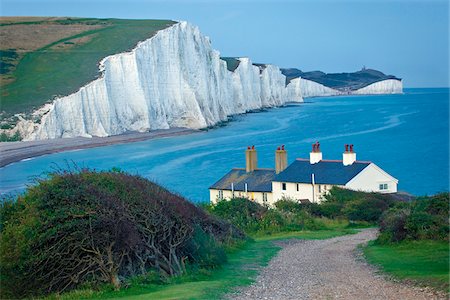
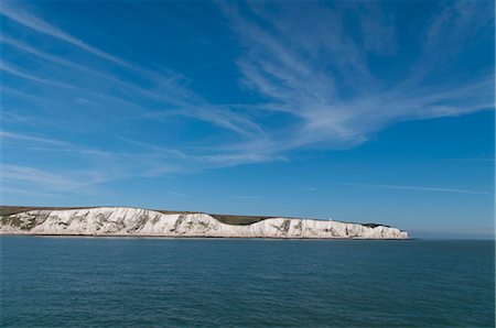
Seven Sisters Cliffs, Seaford Head, Seaford, East Sussex, England
Con derechos protegidos
-
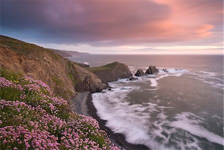
Sea pink wildflowers flowering on the clifftops at Hartland Quay, looking towards Screda Point, Devon, England, United Kingdom, Europe
Con derechos protegidos
-
-
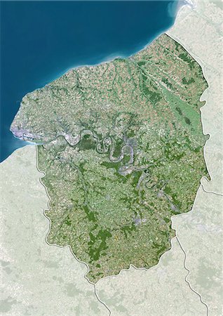
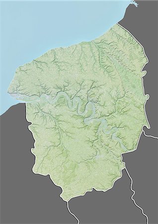
Satellite view of Lower Normandy, France. This image was compiled from data acquired by LANDSAT 5 & 7 satellites.
Con derechos protegidos
-
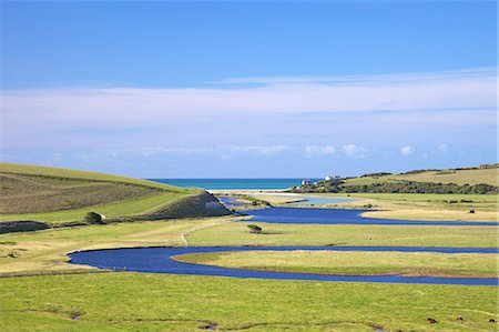
River Cuckmere meets the English Channel at Cuckmere Haven, East Sussex, South Downs National Park, England, United Kingdom, Europe
Con derechos protegidos
-
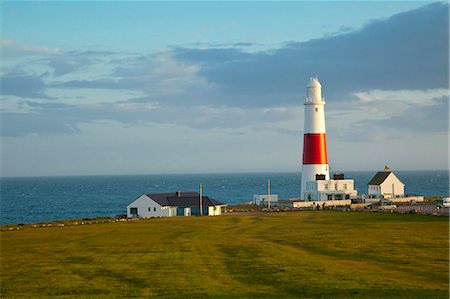
Portland, Dorset, England, the now retired portland bill lowlight lighthouse.
Con derechos protegidos
-

-
Relief map of Lower Normandy, France. This image was compiled from data acquired by LANDSAT 5 & 7 satellites combined with elevation data.
Con derechos protegidos
-
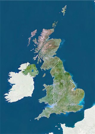
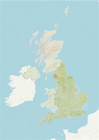
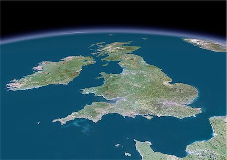
United Kingdom, True Colour Satellite Image With Country Boundaries
Con derechos protegidos
-
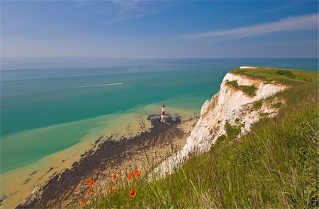
Beachy Head lighthouse, white chalk cliffs, poppies and English Channel, East Sussex, England, United Kingdom, Europe
Con derechos protegidos
-

-
Man Of War cove on the Jurassic Heritage coastline. It is protected by UNESCO as a World heritage site.
Con derechos protegidos
-
Beachy Head lighthouse, East Sussex, English Channel, England, United Kingdom, Europe
Con derechos protegidos
-
-
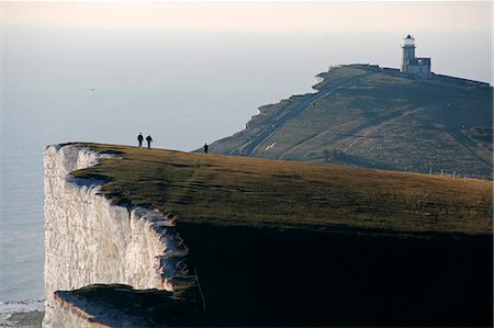
England,East Sussex,Beachy Head. Beachy Head is a chalk headland on the south coast of England,close to the town of Eastbourne. The cliff there is the highest chalk sea cliff in Britain,rising to 162 m (530 ft) above sea level. The peak allows views of the south east coast from Dungeness to the east,to Selsey Bill in the west.
Con derechos protegidos
-
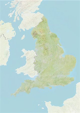
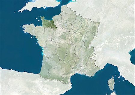
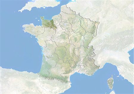
Relief map of England, United Kingdom. This image was compiled from data acquired by LANDSAT 5 & 7 satellites combined with elevation data.
Con derechos protegidos
-

Portland, Dorset, England, Chesil beach and the town of Fortuneswell from portland heights.
Con derechos protegidos
-
-
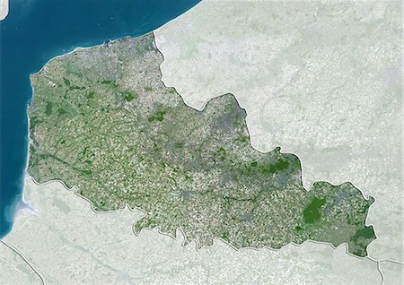
Satellite view of Nord-Pas de Calais, France. This image was compiled from data acquired by LANDSAT 5 & 7 satellites.
Con derechos protegidos
-

France and the Region of Nord-Pas de Calais, True Colour Satellite Image
Con derechos protegidos
-
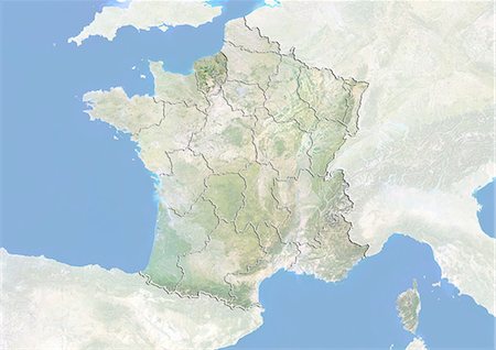
France and the Region of Lower Normandy, True Colour Satellite Image
Con derechos protegidos
-
France and the Region of Lower Normandy, Satellite Image With Bump Effect
Con derechos protegidos
-
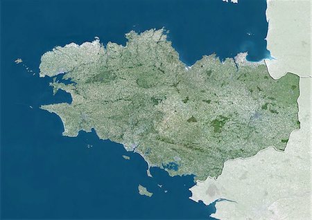
Satellite view of Brittany, France. This image was compiled from data acquired by LANDSAT 5 & 7 satellites.
Con derechos protegidos
-

England,East Sussex,Eastbourne. Paragliding is a recreational and competitive flying sport. A paraglider is a free-flying,foot-launched aircraft. The pilot sits in a harness suspended below a fabric wing,whose shape is formed by the pressure of air entering vents in the front of the wing.
Con derechos protegidos
-
England,East Sussex,Beachy Head. Beachy Head is a chalk headland on the south coast of England,close to the town of Eastbourne. The cliff there is the highest chalk sea cliff in Britain,rising to 162 m (530 ft) above sea level. The peak allows views of the south east coast from Dungeness to the east,to Selsey Bill in the west.
Con derechos protegidos
-
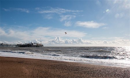
Brighton Pier on the Sussex coast, England, with sunshine, sea and clouds.
Super Valor sin royalties y Suscripción
-
-

England,East Sussex,Beachy Head. Beachy Head is a chalk headland on the south coast of England,close to the town of Eastbourne. The cliff there is the highest chalk sea cliff in Britain,rising to 162 m (530 ft) above sea level. The peak allows views of the south east coast from Dungeness to the east,to Selsey Bill in the west.
Con derechos protegidos
-
France and the Region of Upper Normandy, Satellite Image With Bump Effect
Con derechos protegidos
-
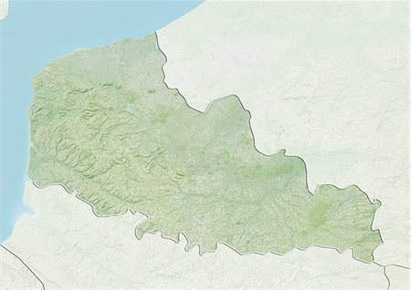
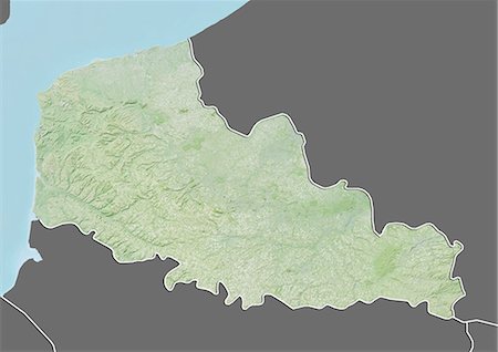
Relief map of Nord-Pas de Calais, France. This image was compiled from data acquired by LANDSAT 5 & 7 satellites combined with elevation data.
Con derechos protegidos
-

Satellite view of Picardy, France. This image was compiled from data acquired by LANDSAT 5 & 7 satellites.
Con derechos protegidos
-
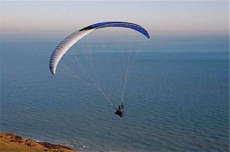
England,East Sussex,Eastbourne. Paragliding is a recreational and competitive flying sport. A paraglider is a free-flying,foot-launched aircraft. The pilot sits in a harness suspended below a fabric wing,whose shape is formed by the pressure of air entering vents in the front of the wing.
Con derechos protegidos
-
Satellite view of Upper Normandy, France. This image was compiled from data acquired by LANDSAT 5 & 7 satellites.
Con derechos protegidos
-

Satellite view of England, United Kingdom. This image was compiled from data acquired by LANDSAT 5 & 7 satellites.
Con derechos protegidos
-
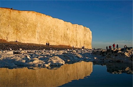
England,East Sussex,Beachy Head. Beachy Head is a chalk headland on the south coast of England,close to the town of Eastbourne. The cliff there is the highest chalk sea cliff in Britain,rising to 162 m (530 ft) above sea level. The peak allows views of the south east coast from Dungeness to the east,to Selsey Bill in the west.
Con derechos protegidos
-
-
England,East Sussex,Beachy Head. Beachy Head is a chalk headland on the south coast of England,close to the town of Eastbourne. The cliff there is the highest chalk sea cliff in Britain,rising to 162 m (530 ft) above sea level. The peak allows views of the south east coast from Dungeness to the east,to Selsey Bill in the west.
Con derechos protegidos
-
Relief map of Upper Normandy, France. This image was compiled from data acquired by LANDSAT 5 & 7 satellites combined with elevation data.
Con derechos protegidos
-
Relief map of Upper Normandy, France. This image was compiled from data acquired by LANDSAT 5 & 7 satellites combined with elevation data.
Con derechos protegidos
-
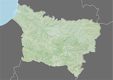
Relief map of Picardy, France. This image was compiled from data acquired by LANDSAT 5 & 7 satellites combined with elevation data.
Con derechos protegidos
-
Relief map of Picardy, France. This image was compiled from data acquired by LANDSAT 5 & 7 satellites combined with elevation data.
Con derechos protegidos
-
Relief map of Nord-Pas de Calais, France. This image was compiled from data acquired by LANDSAT 5 & 7 satellites combined with elevation data.
Con derechos protegidos
-

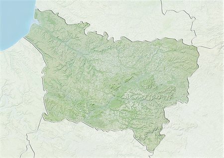
Relief map of Brittany, France. This image was compiled from data acquired by LANDSAT 5 & 7 satellites combined with elevation data.
Con derechos protegidos
-

Relief map of Brittany, France. This image was compiled from data acquired by LANDSAT 5 & 7 satellites combined with elevation data.
Con derechos protegidos
-
England,East Sussex,Beachy Head. Beachy Head is a chalk headland on the south coast of England,close to the town of Eastbourne. The cliff there is the highest chalk sea cliff in Britain,rising to 162 m (530 ft) above sea level. The peak allows views of the south east coast from Dungeness to the east,to Selsey Bill in the west.
Con derechos protegidos
-

Channel Islands, Europe, True Colour Satellite Image. True colour satellite image of the Channel Islands, an archipelago in the English Channel, off the French coast of Normandy. the main islands are Jersey, Guernsey, Alderney, Sark and Herm. Image using LANDSAT 7 data.
Con derechos protegidos
-

-
France and the Region of Picardy, Satellite Image With Bump Effect
Con derechos protegidos
-

France and the Region of Nord-Pas de Calais, Satellite Image With Bump Effect
Con derechos protegidos
-

England,East Sussex,Eastbourne. Eastbourne Pier is a seaside pleasure pier in on the south coast of England.
Con derechos protegidos
-

-
-
-

-

A spectacular sunset over the English Channel near Old Harry Rocks, Dorset, England, United Kingdom, Europe
Con derechos protegidos
-
-

Image of the rocky beach and iconic natural arch from Etretat in Upper Normandy in North of France. Selective focus on the rocks in the first plane.
Super Valor sin royalties y Suscripción
-
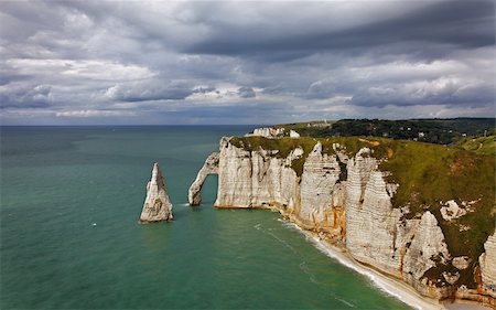
La Falaise d'Amont in Etretat on the Upper Normandy coast in the North of France.
Super Valor sin royalties y Suscripción
-
-
Aerial view of the sea, English Channel, south Devon, England, United Kingdom, Europe
Con derechos protegidos
-

-
-

-

-
-
England,East Sussex,Beachy Head. Beachy Head is a chalk headland on the south coast of England,close to the town of Eastbourne. The cliff there is the highest chalk sea cliff in Britain,rising to 162 m (530 ft) above sea level. The peak allows views of the south east coast from Dungeness to the east,to Selsey Bill in the west.
Con derechos protegidos
-

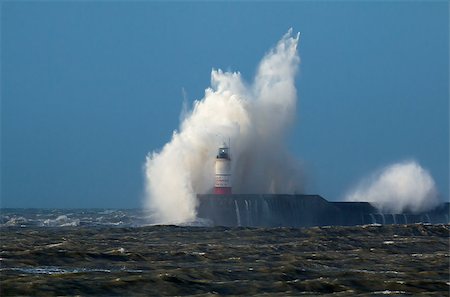
Breaking wave over Newhaven Lighthouse in East Sussex and rough sea.
Super Valor sin royalties y Suscripción
-
Breaking wave over Newhaven Lighthouse in East Sussex, with Gull against white wave and rough sea.
Super Valor sin royalties y Suscripción
-

One of the natural cliffs in Etretat, France. March 2014
Super Valor sin royalties y Suscripción
-
-
-
-

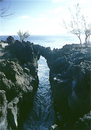
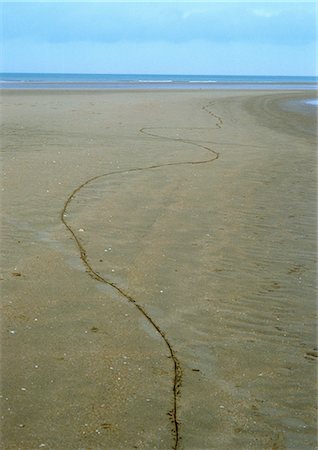
Coastal scene on Sark looking out over the English Channel
Super Valor sin royalties y Suscripción
-

-
-
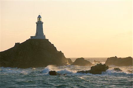
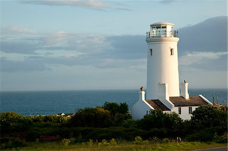
Corbiere lighthouse, St. Brelard-Corbiere Point, Jersey, Channel Islands, United Kingdom, Europe
Con derechos protegidos


