-

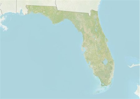
Relief map of the State of Florida, United States. This image was compiled from data acquired by LANDSAT 5 & 7 satellites combined with elevation data.
Rights-Managed
-
-
-
-

Relief map of the State of Wisconsin, United States. This image was compiled from data acquired by LANDSAT 5 & 7 satellites combined with elevation data.
Rights-Managed
-

South America At Night With Borders, True Colour Satellite Image. True colour satellite image of South America at night with borders. This image in Lambert Azimuthal Equal Area projection was compiled from data acquired by LANDSAT 5 & 7 satellites.
Rights-Managed
-

Satellite view of the State of Wisconsin, United States. This image was compiled from data acquired by LANDSAT 5 & 7 satellites.
Rights-Managed
-

United States and the State of Western Virginia, True Colour Satellite Image
Rights-Managed
-

-
Relief map of the State of Florida, United States. This image was compiled from data acquired by LANDSAT 5 & 7 satellites combined with elevation data.
Rights-Managed
-

Satellite view of the State of Montana, United States. This image was compiled from data acquired by LANDSAT 5 & 7 satellites.
Rights-Managed
-
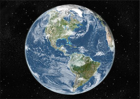
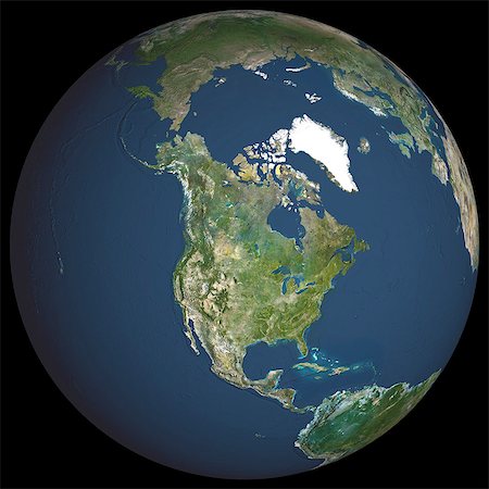
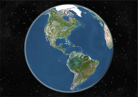
Globe Centred On The Americas, True Colour Satellite Image. True colour satellite image of the Earth centred on the Americas with cloud coverage, at the equinox at 6 p.m GMT. This image in orthographic projection was compiled from data acquired by LANDSAT 5 & 7 satellites.
Rights-Managed
-
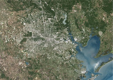
Houston, Texas, Usa, True Colour Satellite Image. Houston, Texas, USA. True colour satellite image of the city of Houston. Composite of 2 images taken on 6 October 1999 & 25 April 2001, using LANDSAT 7 data.
Rights-Managed
-

Globe Centred On The Americas, True Colour Satellite Image. True colour satellite image of the Earth centred on the Americas, during winter solstice at 6 a.m GMT. This image in orthographic projection was compiled from data acquired by LANDSAT 5 & 7 satellites.
Rights-Managed
-
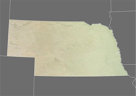
Satellite view of the State of Nebraska, United States. This image was compiled from data acquired by LANDSAT 5 & 7 satellites.
Rights-Managed
-
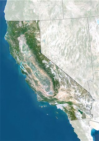
Satellite view of the State of California, United States. This image was compiled from data acquired by LANDSAT 5 & 7 satellites.
Rights-Managed
-

1960s 1970s DEMONSTRATIVE WOMAN TV FORECASTER GIVING WEATHER REPORT POINTING TO MAP LOOKING AT CAMERA
Rights-Managed
-
-
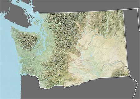
Relief map of the State of Washington, United States. This image was compiled from data acquired by LANDSAT 5 & 7 satellites combined with elevation data.
Rights-Managed
-

Relief map of the State of Oregon, United States. This image was compiled from data acquired by LANDSAT 5 & 7 satellites combined with elevation data.
Rights-Managed
-

-

Globe Centred On The Americas, True Colour Satellite Image. True colour satellite image of the Earth centred on the Americas with cloud coverage, during summer solstice at 6 a.m GMT. This image in orthographic projection was compiled from data acquired by LANDSAT 5 & 7 satellites.
Rights-Managed
-

-
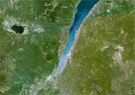
Saint-Lawrence River, Quebec, Canada, True Colour Satellite Image. Satellite image of Quebec city and the Saint-Lawrence river mouth, connection between the Atlantic ocean and the Great Lakes. Image taken on 23 August 2002 using LANDSAT data.
Rights-Managed
-
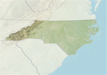
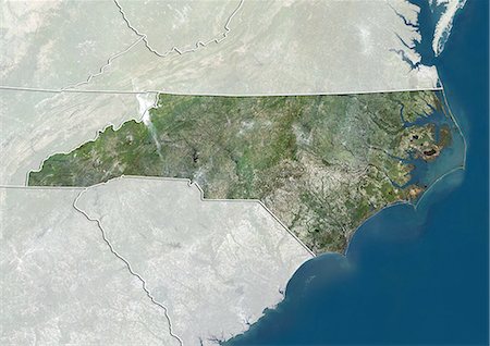
Relief map of the State of North Carolina, United States. This image was compiled from data acquired by LANDSAT 5 & 7 satellites combined with elevation data.
Rights-Managed
-
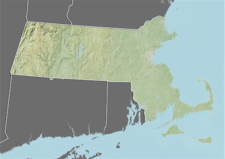
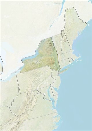
Relief map of the State of Massachusetts, United States. This image was compiled from data acquired by LANDSAT 5 & 7 satellites combined with elevation data.
Rights-Managed
-

Relief map of the State of Massachusetts, United States. This image was compiled from data acquired by LANDSAT 5 & 7 satellites combined with elevation data.
Rights-Managed
-

Relief map of the State of New Mexico, United States. This image was compiled from data acquired by LANDSAT 5 & 7 satellites combined with elevation data.
Rights-Managed
-
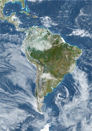
South America With Cloud Coverage, True Colour Satellite Image. True colour satellite image of South America with cloud coverage. This image in Lambert Azimuthal Equal Area projection was compiled from data acquired by LANDSAT 5 & 7 satellites.
Rights-Managed
-
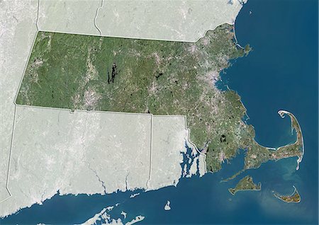
Satellite view of the State of Massachusetts, United States. This image was compiled from data acquired by LANDSAT 5 & 7 satellites.
Rights-Managed
-

Washington D.C., Usa, True Colour Satellite Image. Washington, D.C., USA. True colour satellite image of Washington, D.C., capital city of the USA. Image taken on 5 October 2001 using LANDSAT 7 data.
Rights-Managed
-

-

-
-

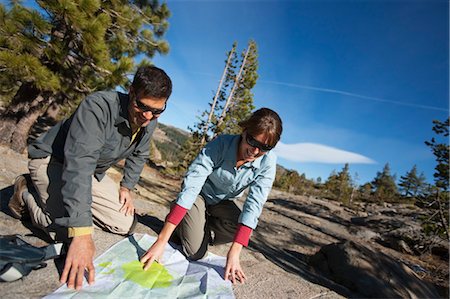
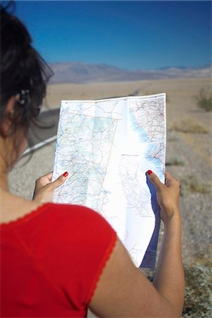
Couple Reading Trail Map while on Day Hike in High Sierra, near Lake Tahoe, California, USA
Rights-Managed
-
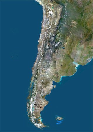
Chile, South America, True Colour Satellite Image With Border. Satellite view of Chile (with border). This image was compiled from data acquired by LANDSAT 5 & 7 satellites.
Rights-Managed
-
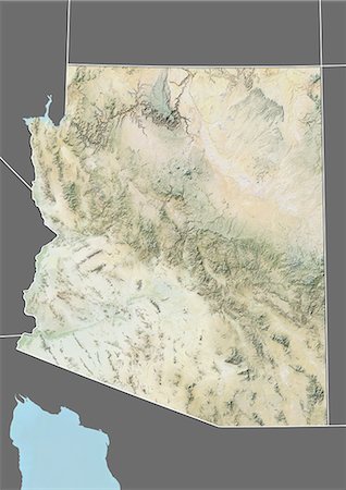
Relief map of the State of Arizona, United States. This image was compiled from data acquired by LANDSAT 5 & 7 satellites combined with elevation data.
Rights-Managed
-
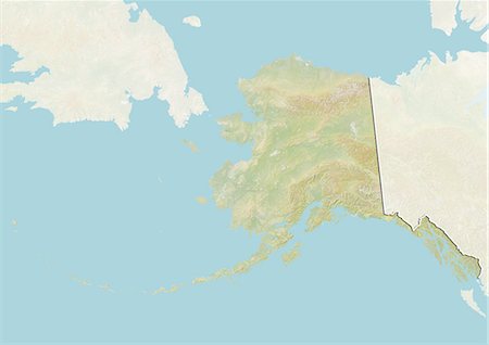
Relief map of the State of Alaska, United States. This image was compiled from data acquired by LANDSAT 5 & 7 satellites combined with elevation data.
Rights-Managed
-

Woman Reading Map as Couple Prepares for a Road Trip, Bend, Oregon, USA
Premium Royalty-Free
-
-
Couple Looking at Trail Map in High Sierra, near Lake Tahoe, California, USA
Rights-Managed
-

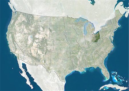
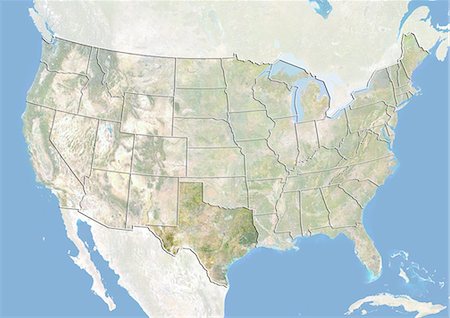
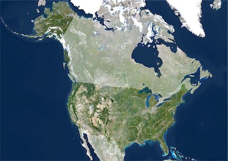
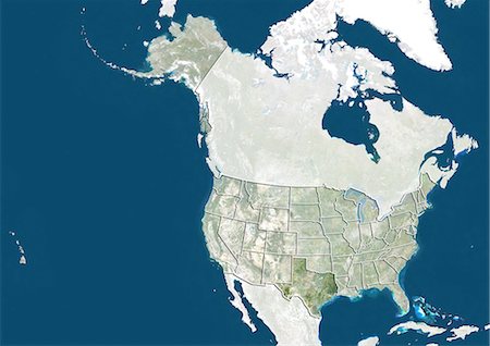
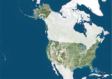
Relief map of the United States and Canada (with border). This image was compiled from data acquired by LANDSAT 5 & 7 satellites combined with elevation data.
Rights-Managed
-
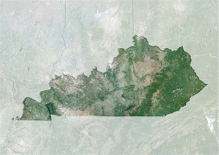
Satellite view of the State of Kentucky, United States. This image was compiled from data acquired by LANDSAT 5 & 7 satellites.
Rights-Managed
-
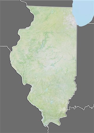
Relief map of the State of Illinois, United States. This image was compiled from data acquired by LANDSAT 5 & 7 satellites combined with elevation data.
Rights-Managed
-

Woman on Side of Highway with Map, Pacific Coast Highway, California, USA
Rights-Managed
-
Globe Centred On The Americas, True Colour Satellite Image. True colour satellite image of the Earth centred on the Americas, during summer solstice at 6 p.m GMT. This image in orthographic projection was compiled from data acquired by LANDSAT 5 & 7 satellites.
Rights-Managed
-
Satellite view of the State of North Carolina, United States. This image was compiled from data acquired by LANDSAT 5 & 7 satellites.
Rights-Managed
-
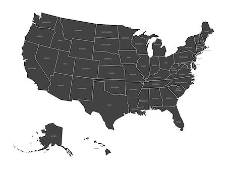
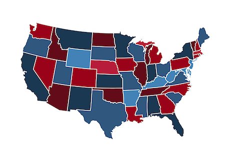
Map of United States of America with state names. Simplified dark grey silhouette vector map on white background.
Budget Royalty-Free & Subscription
-
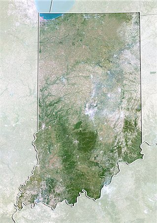
Satellite view of the State of Indiana, United States. This image was compiled from data acquired by LANDSAT 5 & 7 satellites.
Rights-Managed
-
United States (Alaska Incl.), True Colour Satellite Image With Mask. USA (Alaska incl.), true colour satellite image with mask. This image was compiled from data acquired by LANDSAT 5 & 7 satellites.
Rights-Managed
-

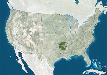
United States and the State of Kentucky, Satellite Image With Bump Effect
Rights-Managed
-

Satellite view of the State of Oregon, United States. This image was compiled from data acquired by LANDSAT 5 & 7 satellites.
Rights-Managed
-
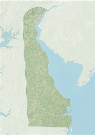
Relief map of the State of Delaware, United States. This image was compiled from data acquired by LANDSAT 5 & 7 satellites combined with elevation data.
Rights-Managed
-

Brazilian woman studying a park map with her mother and grandmother, Boston, Massachusetts, USA
Premium Royalty-Free
-

-
-

-

Woman on Side of Highway with Map, Pacific Coast Highway, California, USA
Rights-Managed
-

United States and the State of Pennsylvania, Satellite Image With Bump Effect
Rights-Managed
-
-

-
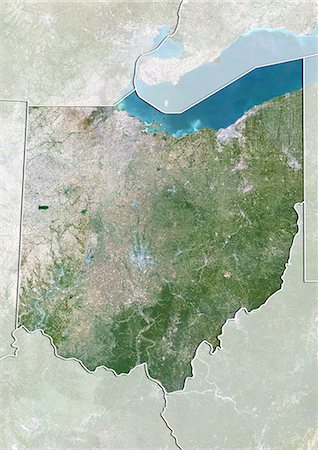
Satellite view of the State of Ohio, United States. This image was compiled from data acquired by LANDSAT 5 & 7 satellites.
Rights-Managed
-
-
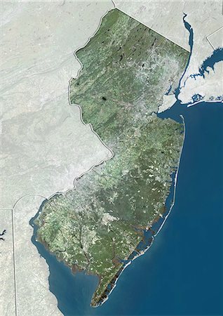
Satellite view of the State of New Jersey, United States. This image was compiled from data acquired by LANDSAT 5 & 7 satellites.
Rights-Managed
-
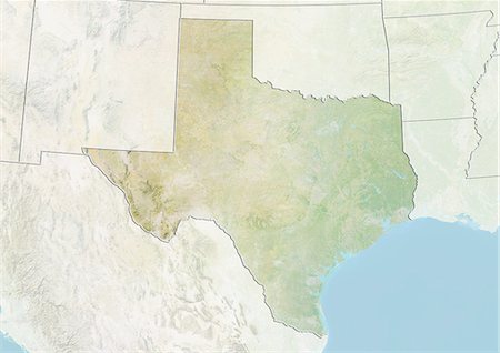
Relief map of the State of Texas, United States. This image was compiled from data acquired by LANDSAT 5 & 7 satellites combined with elevation data.
Rights-Managed
-
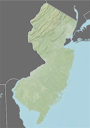
Relief map of the State of New Jersey, United States. This image was compiled from data acquired by LANDSAT 5 & 7 satellites combined with elevation data.
Rights-Managed
-

-
-
-
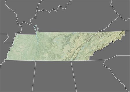
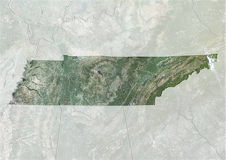
Relief map of the State of Tennessee, United States. This image was compiled from data acquired by LANDSAT 5 & 7 satellites combined with elevation data.
Rights-Managed
-

-

Deforestation, East Rondonia, Brazil, In 2000, True Colour Satellite Image. True colour satellite image showing deforestation in Amazonia in the Eastern part of the State of Rondonia, Brazil. Image in landscape format taken in 2000, using LANDSAT data.
Rights-Managed
-

Woman on Side of Highway with Map, Pacific Coast Highway, California, USA
Rights-Managed
-

Relief map of the State of New Hampshire, United States. This image was compiled from data acquired by LANDSAT 5 & 7 satellites combined with elevation data.
Rights-Managed
-

El Paso, Texas, Usa, True Colour Satellite Image. El Paso, Texas, USA. True colour satellite image of the city of El Paso, taken on 13 June 2001, using LANDSAT 7 data.
Rights-Managed
-
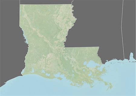
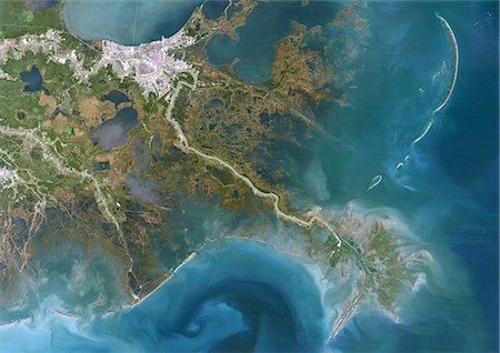
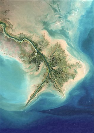
Relief map of the State of Louisiana, United States. This image was taken in 2003 before Hurricane Katrina. It was compiled from data acquired by LANDSAT 7 satellite combined with elevation data.
Rights-Managed
-
-
Whole Earth Centred On Pacific Ocean, True Colour Satellite Image. True colour satellite image of the whole Earth centred on the Pacific Ocean, with country borders and cloud coverage. This image in Miller projection was compiled from data acquired by LANDSAT 5 & 7 satellites.
Rights-Managed
-
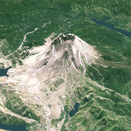
Mount St Helens In 3D, North West View, Washington State, Usa, True Colour Satellite Image. Mount St-Helens, USA, true colour satellite image. North-West view of Mount St-Helens in 3D, an active volcano (2250m high) in Washington State, US. Image using LANDSAT data. Print size 30 x 30 cm.
Rights-Managed
-

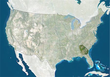
United States and the State of South Carolina, Satellite Image With Bump Effect
Rights-Managed
-
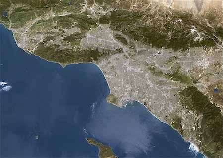
Los Angeles, California, Usa, True Colour Satellite Image. Los Angeles, California, USA. True colour satellite image of the city of Los Angeles. Composite of 2 images taken on 24 April & 1 May 2000, using LANDSAT 7 data.
Rights-Managed
-
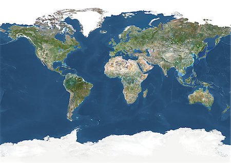
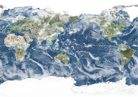
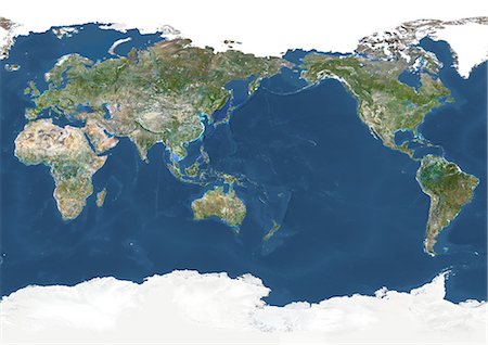
Whole Earth With Country Borders And Major Rivers, True Colour Satellite Image. True colour satellite image of the whole Earth with country borders and major rivers. This image in Miller projection was compiled from data acquired by LANDSAT 5 & 7 satellites.
Rights-Managed
-
-
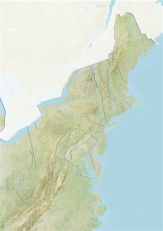
State of Pennsylvania and Northeastern United States, True Colour Satellite Image
Rights-Managed
-

South America With Country Borders, True Colour Satellite Image. True colour satellite image of South America with country borders. This image in Lambert Azimuthal Equal Area projection was compiled from data acquired by LANDSAT 5 & 7 satellites.
Rights-Managed
-
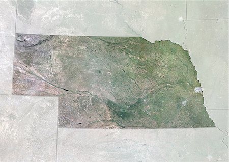
Relief map of the State of Nebraska, United States. This image was compiled from data acquired by LANDSAT 5 & 7 satellites combined with elevation data.
Rights-Managed
-
-
Satellite view of the State of Tennessee, United States. This image was compiled from data acquired by LANDSAT 5 & 7 satellites.
Rights-Managed
-
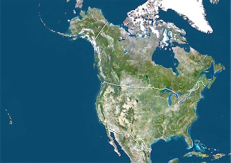
Satellite view of the United States and Canada (with border). This image was compiled from data acquired by LANDSAT 5 & 7 satellites.
Rights-Managed
-
Whole Earth Centred On Pacific Ocean, True Colour Satellite Image. True colour satellite image of the whole Earth centred on the Pacific Ocean, with country borders and major rivers. This image in Miller projection was compiled from data acquired by LANDSAT 5 & 7 satellites.
Rights-Managed


