-

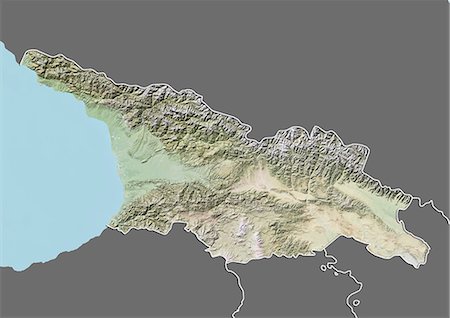
Satellite view of the Caucasus. This image was compiled from data acquired in 2014 by Landsat 8 satellite.
Rights-Managed
-
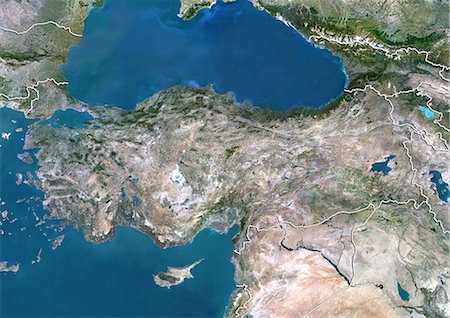
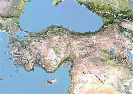
Satellite view of the Middle East. This image was compiled from data acquired in 2014 by Landsat 8 satellite.
Rights-Managed
-
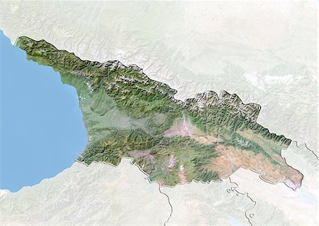
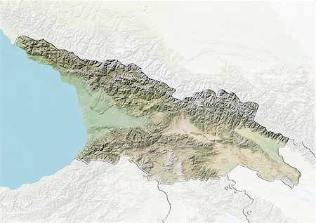
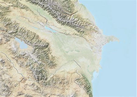
Relief map of Georgia (with border and mask). This image was compiled from data acquired by landsat 5 & 7 satellites combined with elevation data.
Rights-Managed
-

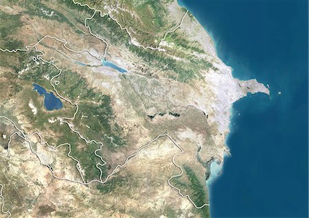
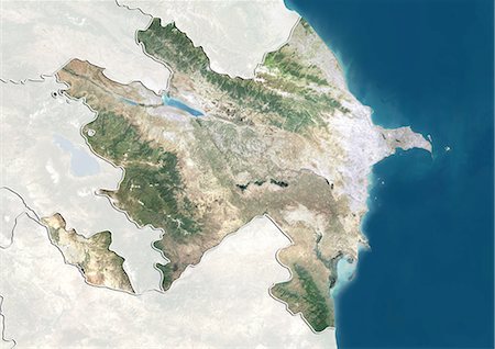
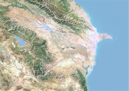
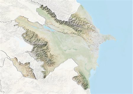
Relief map of Azerbaijan (with border and mask). This image was compiled from data acquired by landsat 5 & 7 satellites combined with elevation data.
Rights-Managed
-

-

-

-
-

-
-
-
-
-

-
-
-
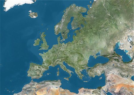
Satellite view of Europe. This image was compiled from data acquired by Landsat 7 & 8 satellites.
Rights-Managed
-

Satellite view of the Persian Gulf. This image was compiled from data acquired in 2014 by Landsat 8 satellite.
Rights-Managed
-

Satellite view of North Africa. This image was compiled from data acquired by Landsat 7 & 8 satellites.
Rights-Managed
-
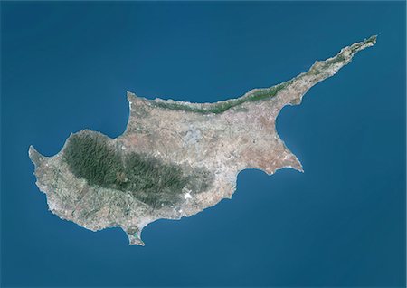
Satellite view of Cyprus. This image was compiled from data acquired by Landsat 8 satellite in 2014.
Rights-Managed
-

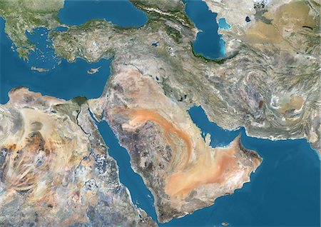
Satellite view of the Arabian Peninsula. This image was compiled from data acquired in 2014 by Landsat 8 satellite.
Rights-Managed
-
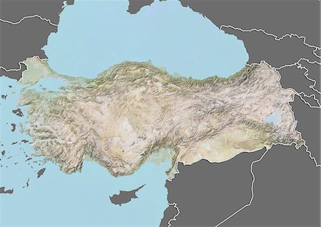
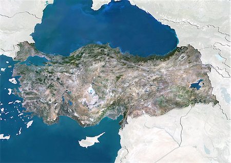
Relief map of Turkey (with border and mask). This image was compiled from data acquired by landsat 5 & 7 satellites combined with elevation data.
Rights-Managed
-
-
-
-

-

-

-

Satellite view of Europe in winter, with partial snow cover. This image was compiled from data acquired by Landsat 7 & 8 satellites.
Rights-Managed
-
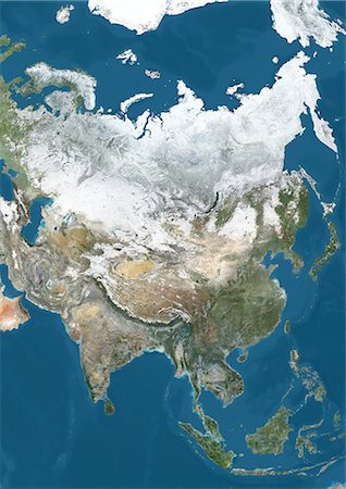
Satellite view of Asia in winter, with partial snow cover. This image was compiled from data acquired by Landsat 7 & 8 satellites.
Rights-Managed
-

Satellite view of Africa. This image was compiled from data acquired by Landsat 7 & 8 satellites.
Rights-Managed
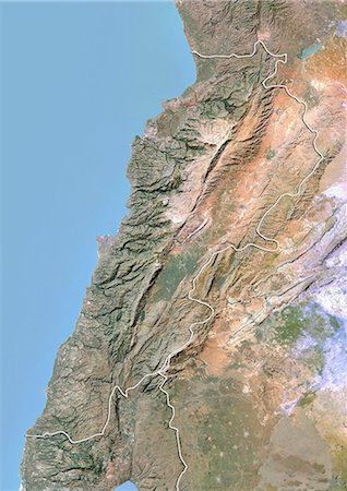
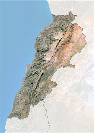
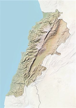
-
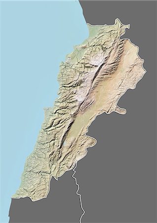
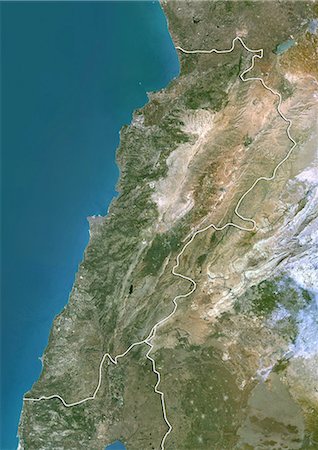
Relief map of Lebanon (with border and mask). This image was compiled from data acquired by landsat 5 & 7 satellites combined with elevation data.
Rights-Managed
-
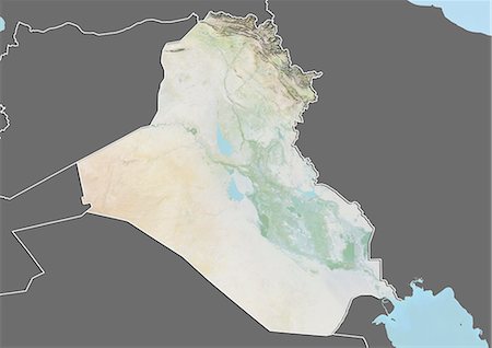
Relief map of Iraq (with border and mask). This image was compiled from data acquired by landsat 5 & 7 satellites combined with elevation data.
Rights-Managed
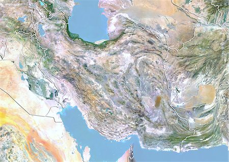
-

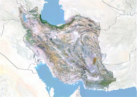
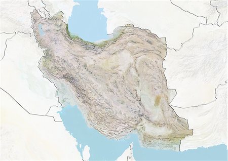
Relief map of Iran (with border and mask). This image was compiled from data acquired by landsat 5 & 7 satellites combined with elevation data.
Rights-Managed
-

Relief map of Afghanistan (with border and mask). This image was compiled from data acquired by landsat 5 & 7 satellites combined with elevation data.
Rights-Managed
-
-

-
-
-

-
-

-

-

-
-
-

-
-

-

-

-

-

-

-

Satellite view of West Nusa Tenggara Province, Indonesia (with country boundaries and mask). The image shows the two largest islands in the province which are Lombok in the west and the larger Sumbawa island in the east. This image was compiled from data acquired by Landsat satellites.
Rights-Managed
-

Satellite view of Taiwan. This image was compiled from data acquired by Landsat satellites.
Rights-Managed
-
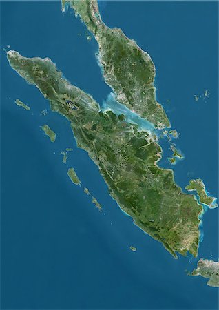
Satellite view of Sumatra, Malaysia and Singapore. This image was compiled from data acquired by Landsat satellites.
Rights-Managed
-
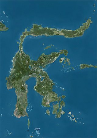
Satellite view of Sulawesi, Indonesia. This image was compiled from data acquired by Landsat satellites.
Rights-Managed
-
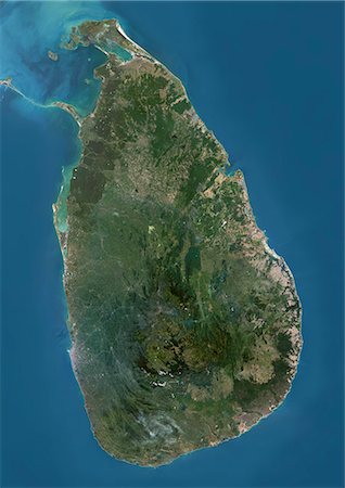
Satellite view of Sri Lanka. This image was compiled from data acquired by Landsat 8 satellite in 2014.
Rights-Managed
-

Satellite view of Southeast Asia. This image was compiled from data acquired by Landsat 7 & 8 satellites.
Rights-Managed
-

Satellite view of the Maluku Islands, Indonesia. This image was compiled from data acquired by Landsat satellites.
Rights-Managed
-

Satellite view of Japan and Korean Peninsula. This image was compiled from data acquired by Landsat satellites.
Rights-Managed
-

Satellite view of Japan and Korean Peninsula. This image was compiled from data acquired by Landsat satellites.
Rights-Managed
-
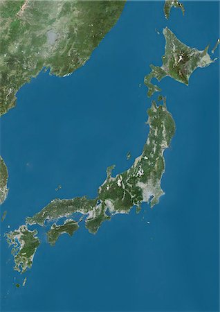
Satellite view of Japan. This image was compiled from data acquired by Landsat satellites.
Rights-Managed
-
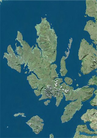
Satellite view of the Isle of Skye, Scotland. It is the largest island in the Inner Hebrides of Scotland. The Cuillin mountains dominate the Isle of Skye. This image was compiled from data acquired by Landsat satellites.
Rights-Managed
-

Satellite view of Asia. This image was compiled from data acquired by LANDSAT 7 & 8 satellites.
Rights-Managed
-
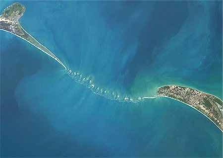
Satellite view of Adam's Bridge. This chain of limestone shoals connects Sri Lanka to India. This image was taken in 2014 by Landsat 8 satellite.
Rights-Managed
-

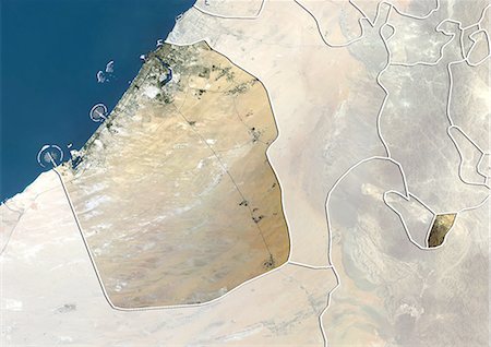
Satellite view of the Emirate of Sharjah, United Arab Emirates. This image was compiled from data acquired by LANDSAT 5 & 7 satellites.
Rights-Managed
-
Relief map of the Emirate of Sharjah, United Arab Emirates. This image was compiled from data acquired by LANDSAT 5 & 7 satellites combined with elevation data.
Rights-Managed
-
Satellite view of the Emirate of Dubai, United Arab Emirates. This image was compiled from data acquired by LANDSAT 5 & 7 satellites.
Rights-Managed
-
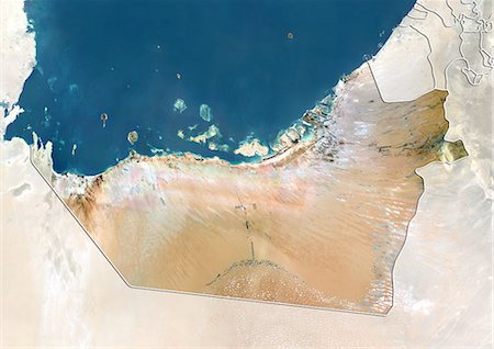
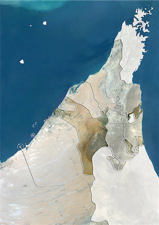
Satellite view of the Emirate of Abu Dhabi, United Arab Emirates. This image was compiled from data acquired by LANDSAT 5 & 7 satellites.
Rights-Managed
-

Relief map of the Emirate of Abu Dhabi, United Arab Emirates. This image was compiled from data acquired by LANDSAT 5 & 7 satellites combined with elevation data.
Rights-Managed
-

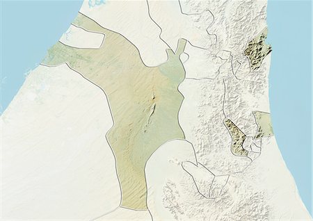
Relief map of Yemen (with border and mask). This image was compiled from data acquired by landsat 5 & 7 satellites combined with elevation data.
Rights-Managed
-
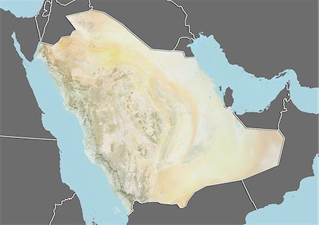
Relief map of Saudi Arabia (with border and mask). This image was compiled from data acquired by landsat 5 & 7 satellites combined with elevation data.
Rights-Managed
-
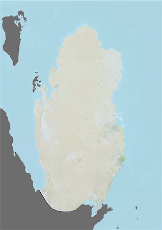
Relief map of Qatar (with border and mask). This image was compiled from data acquired by landsat 5 & 7 satellites combined with elevation data.
Rights-Managed
-

The Emirates of Dubai and Sharjah and Northern UAE, True Colour Satellite Image
Rights-Managed
-

The Emirates of Dubai and Sharjah and Northern UAE, Satellite Image With Bump Effect
Rights-Managed
-

-
-

-

-

-

-

-

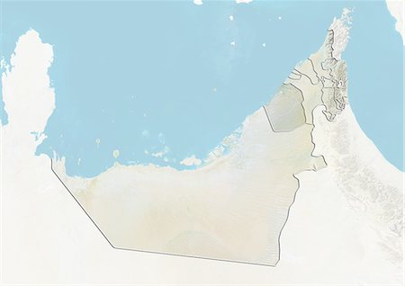
United Arab Emirates, True Colour Satellite Image With Emirate Boundaries
Rights-Managed
-

-

United Arab Emirates and the Emirate of Sharjah, True Colour Satellite Image
Rights-Managed
-

-

United Arab Emirates and the Emirate of Dubai, True Colour Satellite Image
Rights-Managed
-