-
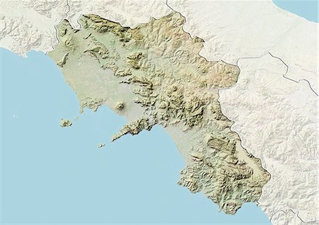
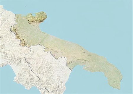
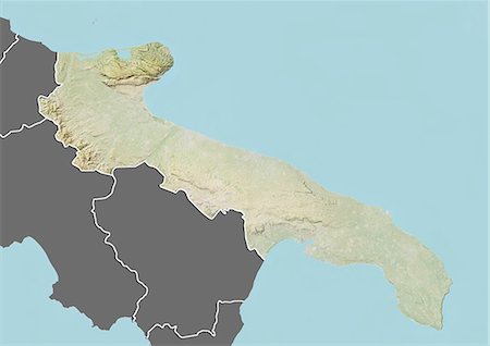
Relief map of the region of Campania, Italy. This image was compiled from data acquired by LANDSAT 5 & 7 satellites combined with elevation data.
Rights-Managed
-
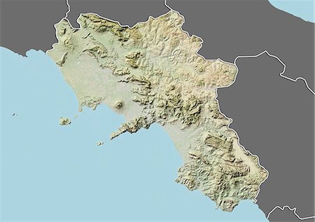
Relief map of the region of Campania, Italy. This image was compiled from data acquired by LANDSAT 5 & 7 satellites combined with elevation data.
Rights-Managed
-

-

Satellite view of the region of Campania, Italy. This image was compiled from data acquired by LANDSAT 5 & 7 satellites.
Rights-Managed
-
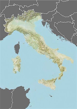
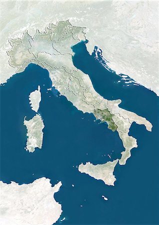
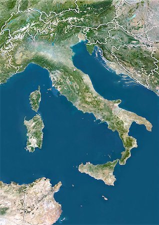
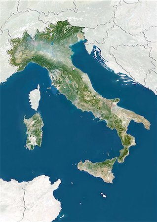
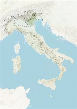
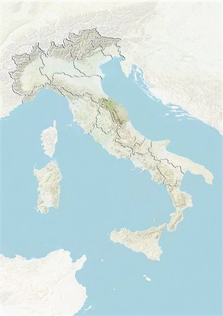
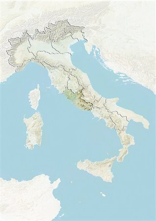
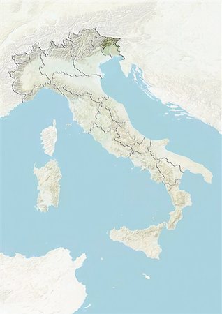
Relief map of Italy (with border and mask). This image was compiled from data acquired by landsat 5 & 7 satellites combined with elevation data.
Rights-Managed
-

-
-

-

-

-

-

-
-
-

-

-

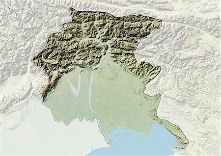
Relief map of the region of Veneto, Italy. This image was compiled from data acquired by LANDSAT 5 & 7 satellites combined with elevation data.
Rights-Managed
-
Relief map of the region of Veneto, Italy. This image was compiled from data acquired by LANDSAT 5 & 7 satellites combined with elevation data.
Rights-Managed
-
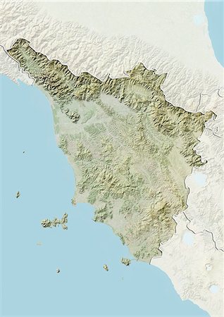
Relief map of the region of Tuscany, Italy. This image was compiled from data acquired by LANDSAT 5 & 7 satellites combined with elevation data.
Rights-Managed
-

Relief map of the region of Tuscany, Italy. This image was compiled from data acquired by LANDSAT 5 & 7 satellites combined with elevation data.
Rights-Managed
-
Relief map of the region of Molise, Italy. This image was compiled from data acquired by LANDSAT 5 & 7 satellites combined with elevation data.
Rights-Managed
-

Relief map of the region of Molise, Italy. This image was compiled from data acquired by LANDSAT 5 & 7 satellites combined with elevation data.
Rights-Managed
-

Relief map of the region of Marche, Italy. This image was compiled from data acquired by LANDSAT 5 & 7 satellites combined with elevation data.
Rights-Managed
-

Relief map of the region of Marche, Italy. This image was compiled from data acquired by LANDSAT 5 & 7 satellites combined with elevation data.
Rights-Managed
-

Relief map of the region of Liguria, Italy. This image was compiled from data acquired by LANDSAT 5 & 7 satellites combined with elevation data.
Rights-Managed
-
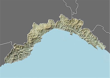
Relief map of the region of Liguria, Italy. This image was compiled from data acquired by LANDSAT 5 & 7 satellites combined with elevation data.
Rights-Managed
-

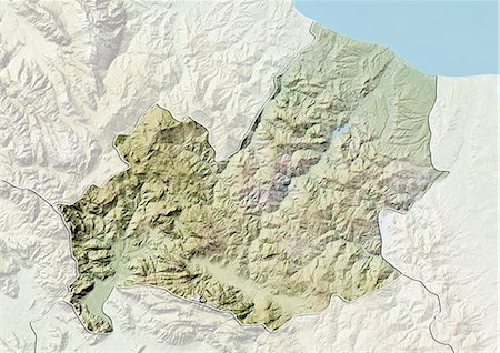
Relief map of the region of Lazio, Italy. This image was compiled from data acquired by LANDSAT 5 & 7 satellites combined with elevation data.
Rights-Managed
-
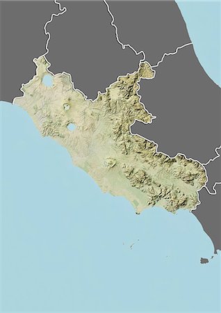
Relief map of the region of Lazio, Italy. This image was compiled from data acquired by LANDSAT 5 & 7 satellites combined with elevation data.
Rights-Managed
-
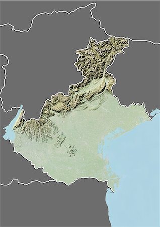
Relief map of the region of Friuli-Venezia Giulia, Italy. This image was compiled from data acquired by LANDSAT 5 & 7 satellites combined with elevation data.
Rights-Managed
-

Relief map of the region of Friuli-Venezia Giulia, Italy. This image was compiled from data acquired by LANDSAT 5 & 7 satellites combined with elevation data.
Rights-Managed
-
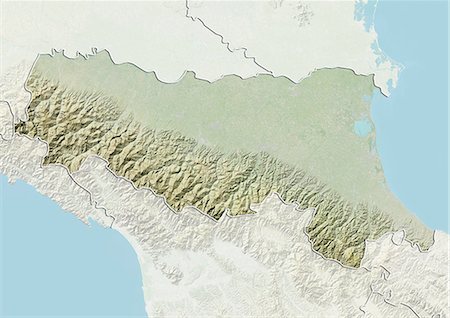
Relief map of the region of Emilia Romagna, Italy. This image was compiled from data acquired by LANDSAT 5 & 7 satellites combined with elevation data.
Rights-Managed
-
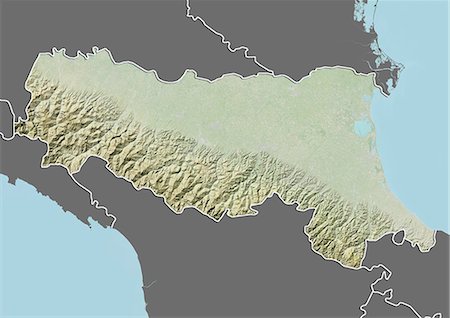
Relief map of the region of Emilia Romagna, Italy. This image was compiled from data acquired by LANDSAT 5 & 7 satellites combined with elevation data.
Rights-Managed
-
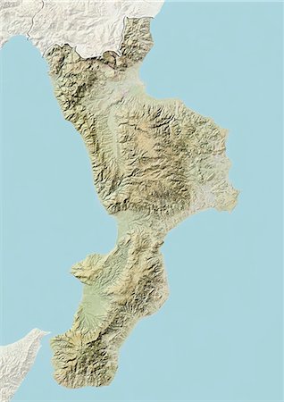
Relief map of the region of Calabria, Italy. This image was compiled from data acquired by LANDSAT 5 & 7 satellites combined with elevation data.
Rights-Managed
-

Relief map of the region of Calabria, Italy. This image was compiled from data acquired by LANDSAT 5 & 7 satellites combined with elevation data.
Rights-Managed
-
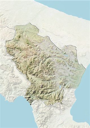
Relief map of the region of Basilicata, Italy. This image was compiled from data acquired by LANDSAT 5 & 7 satellites combined with elevation data.
Rights-Managed
-

Relief map of the region of Basilicata, Italy. This image was compiled from data acquired by LANDSAT 5 & 7 satellites combined with elevation data.
Rights-Managed
-
Relief map of the region of Apulia, Italy. This image was compiled from data acquired by LANDSAT 5 & 7 satellites combined with elevation data.
Rights-Managed
-
Relief map of the region of Apulia, Italy. This image was compiled from data acquired by LANDSAT 5 & 7 satellites combined with elevation data.
Rights-Managed
-

Relief map of the region of Abruzzo, Italy. This image was compiled from data acquired by LANDSAT 5 & 7 satellites combined with elevation data.
Rights-Managed
-

Relief map of the region of Abruzzo, Italy. This image was compiled from data acquired by LANDSAT 5 & 7 satellites combined with elevation data.
Rights-Managed
-

-

-
-

-
-

-

-
-
-

-

-

-

-

-
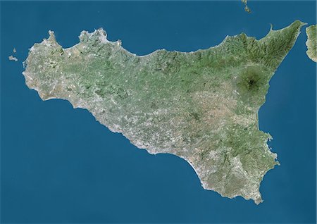
Satellite view of Sicily, Italy. Mount Etna, on the East coast of Sicily, is the largest active volcano in Europe. This image was compiled from data acquired by Landsat satellites.
Rights-Managed
-

Satellite view of Sardinia, Italy. It is the second-largest island in the Mediterranean Sea. This image was compiled from data acquired by Landsat satellites.
Rights-Managed
-

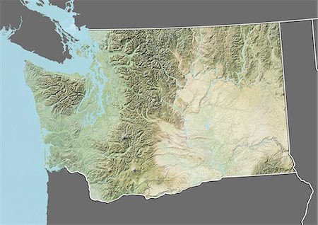
Relief map of the State of Washington, United States. This image was compiled from data acquired by LANDSAT 5 & 7 satellites combined with elevation data.
Rights-Managed
-
Relief map of the State of Washington, United States. This image was compiled from data acquired by LANDSAT 5 & 7 satellites combined with elevation data.
Rights-Managed
-

Relief map of the State of Virginia, United States. This image was compiled from data acquired by LANDSAT 5 & 7 satellites combined with elevation data.
Rights-Managed
-

Relief map of the State of Virginia, United States. This image was compiled from data acquired by LANDSAT 5 & 7 satellites combined with elevation data.
Rights-Managed
-
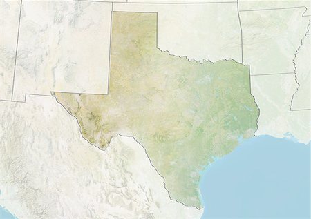
Relief map of the State of Texas, United States. This image was compiled from data acquired by LANDSAT 5 & 7 satellites combined with elevation data.
Rights-Managed
-
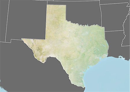
Relief map of the State of Texas, United States. This image was compiled from data acquired by LANDSAT 5 & 7 satellites combined with elevation data.
Rights-Managed
-

Relief map of the State of South Carolina, United States. This image was compiled from data acquired by LANDSAT 5 & 7 satellites combined with elevation data.
Rights-Managed
-

Relief map of the State of South Carolina, United States. This image was compiled from data acquired by LANDSAT 5 & 7 satellites combined with elevation data.
Rights-Managed
-
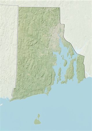
Relief map of the State of Rhode Island, United States. This image was compiled from data acquired by LANDSAT 5 & 7 satellites combined with elevation data.
Rights-Managed
-
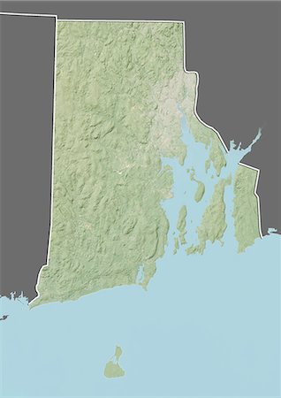
Relief map of the State of Rhode Island, United States. This image was compiled from data acquired by LANDSAT 5 & 7 satellites combined with elevation data.
Rights-Managed
-

Relief map of the State of Oregon, United States. This image was compiled from data acquired by LANDSAT 5 & 7 satellites combined with elevation data.
Rights-Managed
-

Relief map of the State of Oregon, United States. This image was compiled from data acquired by LANDSAT 5 & 7 satellites combined with elevation data.
Rights-Managed
-

Relief map of the State of Ohio, United States. This image was compiled from data acquired by LANDSAT 5 & 7 satellites combined with elevation data.
Rights-Managed
-
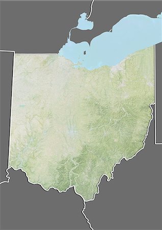
Relief map of the State of Ohio, United States. This image was compiled from data acquired by LANDSAT 5 & 7 satellites combined with elevation data.
Rights-Managed
-
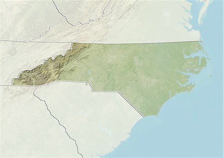
Relief map of the State of North Carolina, United States. This image was compiled from data acquired by LANDSAT 5 & 7 satellites combined with elevation data.
Rights-Managed
-
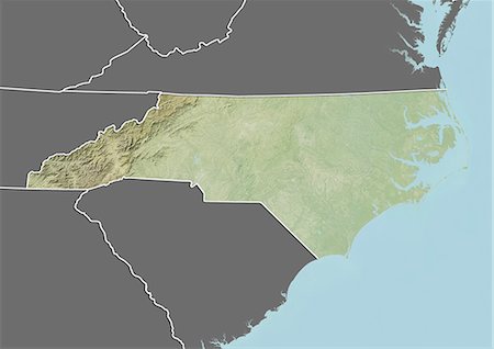
Relief map of the State of North Carolina, United States. This image was compiled from data acquired by LANDSAT 5 & 7 satellites combined with elevation data.
Rights-Managed
-

Relief map of the State of New York, United States. This image was compiled from data acquired by LANDSAT 5 & 7 satellites combined with elevation data.
Rights-Managed
-

Relief map of the State of New York, United States. This image was compiled from data acquired by LANDSAT 5 & 7 satellites combined with elevation data.
Rights-Managed
-

Relief map of the State of New Jersey, United States. This image was compiled from data acquired by LANDSAT 5 & 7 satellites combined with elevation data.
Rights-Managed
-
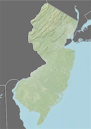
Relief map of the State of New Jersey, United States. This image was compiled from data acquired by LANDSAT 5 & 7 satellites combined with elevation data.
Rights-Managed
-
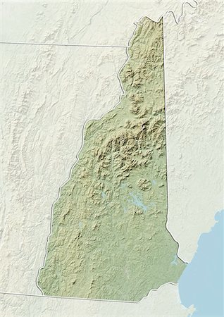
Relief map of the State of New Hampshire, United States. This image was compiled from data acquired by LANDSAT 5 & 7 satellites combined with elevation data.
Rights-Managed
-

Relief map of the State of New Hampshire, United States. This image was compiled from data acquired by LANDSAT 5 & 7 satellites combined with elevation data.
Rights-Managed
-

Relief map of the State of Mississippi, United States. This image was compiled from data acquired by LANDSAT 5 & 7 satellites combined with elevation data.
Rights-Managed
-

Relief map of the State of Mississippi, United States. This image was compiled from data acquired by LANDSAT 5 & 7 satellites combined with elevation data.
Rights-Managed
-
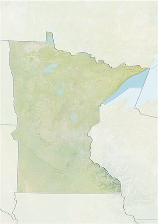
Relief map of the State of Minnesota, United States. This image was compiled from data acquired by LANDSAT 5 & 7 satellites combined with elevation data.
Rights-Managed
-
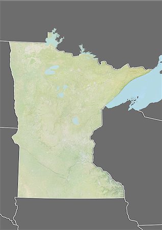
Relief map of the State of Minnesota, United States. This image was compiled from data acquired by LANDSAT 5 & 7 satellites combined with elevation data.
Rights-Managed
-
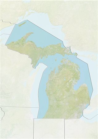
Relief map of the State of Michigan, United States. This image was compiled from data acquired by LANDSAT 5 & 7 satellites combined with elevation data.
Rights-Managed
-
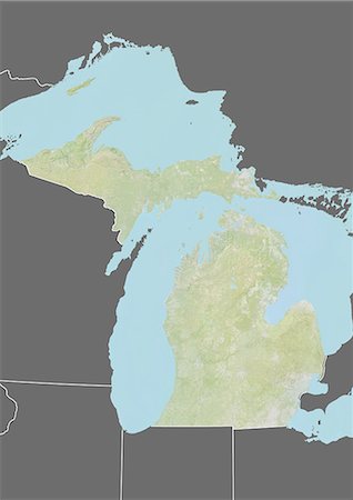
Relief map of the State of Michigan, United States. This image was compiled from data acquired by LANDSAT 5 & 7 satellites combined with elevation data.
Rights-Managed
-

Relief map of the State of Massachusetts, United States. This image was compiled from data acquired by LANDSAT 5 & 7 satellites combined with elevation data.
Rights-Managed
-
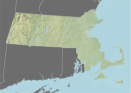
Relief map of the State of Massachusetts, United States. This image was compiled from data acquired by LANDSAT 5 & 7 satellites combined with elevation data.
Rights-Managed
-

Relief map of the State of Maryland, United States. This image was compiled from data acquired by LANDSAT 5 & 7 satellites combined with elevation data.
Rights-Managed
-

Relief map of the State of Maryland, United States. This image was compiled from data acquired by LANDSAT 5 & 7 satellites combined with elevation data.
Rights-Managed
-

Relief map of the State of Maine, United States. This image was compiled from data acquired by LANDSAT 5 & 7 satellites combined with elevation data.
Rights-Managed
-

Relief map of the State of Maine, United States. This image was compiled from data acquired by LANDSAT 5 & 7 satellites combined with elevation data.
Rights-Managed


