-

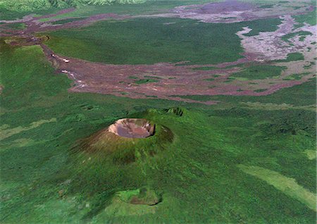
Piton De La Fournaise Volcano In 3D, Reunion Island, French Overseas, True Colour Satellite Image. Piton de la Fournaise, Reunion, true colour satellite image. 3D satellite view of the Piton de la Fournaise (2631m), one of the world's most active volcanoes, located on the South East part of Reunion Island, in the Indian Ocean. Image using LANDSAT data.
Rights-Managed
-

Piton De La Fournaise Volcano, Reunion Island, French Overseas, True Colour Satellite Image. Piton de la Fournaise, Reunion island, French overseas, true colour satellite image. Piton de la Fournaise (2631m), one of the world's most active volcanoes, is located on the South East part of Reunion Island, in the Indian Ocean. Image taken on 19 June 2000 using LANDSAT data. Print size 30 x 30 cm.
Rights-Managed
-
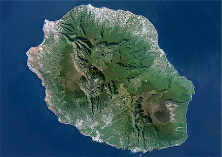
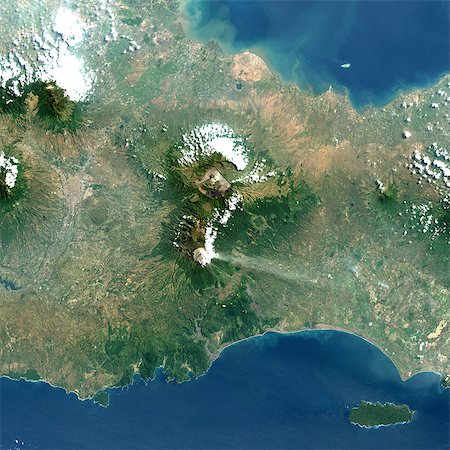
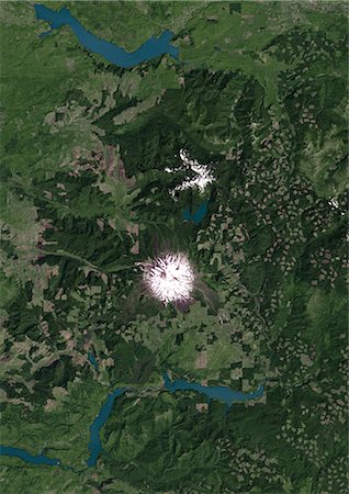
Piton De La Fournaise, Reunion Island, French Overseas, True Colour Satellite Image. Reunion Island, French overseas, true colour satellite image. Reunion island is made of two volcanos, Piton des Neiges volcano, the highest point on the island at 3069m, and Piton de la Fournaise (2632m), an active shield volcano on the Eastern end of Reunion Island. Image taken on 19 June 2000 using LANDSAT data.
Rights-Managed
-
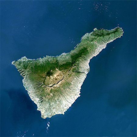
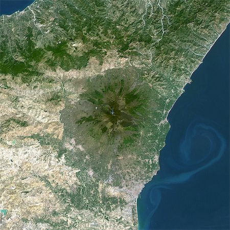
Teide Volcano, Canary Islands, Spain, True Colour Satellite Image. Teide volcano, Spain, true colour satellite image. Teide Volcano (3718 m) on the island of Tenerife in the Canary Islands is the highest peak in Spain. Composite image dated 2000-2001 using LANDSAT data. Print size 30 x 30 cm.
Rights-Managed
-

Ardoukoba Volcano, Djibouti, True Colour Satellite Image. Ardoukoba, Djibouti, true colour satellite image. Ardoukoba is a volcano located close to Assal Lake in Djibouti. Image taken on 13 May 2000 using LANDSAT data. Print size 30 x 30 cm.
Rights-Managed
-

Tousside Volcano, Chad, True Colour Satellite Image. Tousside volcano, Chad, true colour satellite image. Tousside is a volcano (3265m) in the North-West part of Chad. Composite image dated 2001 using LANDSAT data. Print size 30 x 30 cm.
Rights-Managed
-

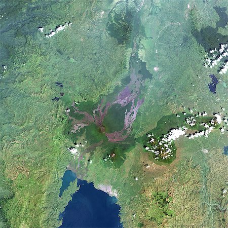
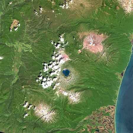
Ol Doinyo Lengai Volcano, Tanzania, True Colour Satellite Image. Lengai, Tanzanie, true colour satellite image. The active volcano Ol Doinyo Lengai (2890m), whose summit is partly covered with clouds, is at the bottom part of the image. North is Lake Natron. Composite image dated 2000 using LANDSAT data. Print size 30 x 30 cm.
Rights-Managed
-
Nyiragongo Volcano, Democratic Republic Of Congo, True Colour Satellite Image. Nyiragongo, Congo, true colour satellite image. Nyiragongo is one of the most active volcanoes in Africa, located about 10 km from the city of Goma. Image taken on 11 December 2001 using LANDSAT data. Print size 30 x 30 cm.
Rights-Managed
-
Erta Ale Volcano, Ethiopia, True Colour Satellite Image. Erta Ale volcano, Ethiopia, true colour satellite image. Erta Ale (613m) is a shield volcano in the Afar region of East Africa. Image taken on 5 February 2002 using LANDSAT data. Print size 30 x 30 cm.
Rights-Managed
-
Volcano Nyiragongo In 3D, Democratic Republic Of Congo, True Colour Satellite Image. Nyiragongo, Congo, true colour satellite image. Nyiragongo is one of Africa's most active volcano, located 10km from the town of Goma. Image taken on 11 December 2001 using LANDSAT data.
Rights-Managed
-
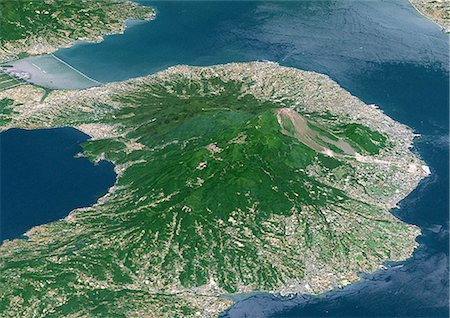
Unzen Volcano In 3D, Japan, True Colour Satellite Image. Unzen, Japan, true colour satellite image. 3D satellite view of Unzen volcano, located on the Island of Kyushu, East of Nagasaki. Image taken on 15 May 1993 using LANDSAT data.
Rights-Managed
-

Galunggung Volcano, Java, Indonesia, True Colour Satellite Image. Galunggung, Java, Indonesia, true colour satellite image. Galunggung volcano (2168m) is located in West Java, Indonesia, near the city of Tasikmalaya. Image taken on 22 June 2001 using LANDSAT data. Print size 30 x 30 cm.
Rights-Managed
-

Pinatubo Volcano, Philippines, True Colour Satellite Image. Mount Pinatubo, Philippines, true colour satellite image. Mount Pinatubo (1486m) is in the Philippines. The 2,5km-wide caldera formed after the 1991 eruption is today filled with a lake. Composite image dated 01/11/2001 and 26/11/2001 using LANDSAT data. Print size 30 x 30 cm.
Rights-Managed
-

Mayon Volcano, Philippines, True Colour Satellite Image. Mayon volcano, Philippines, true colour satellite image. Mayon (2462m), on Luzon island, is the most active volcano in the Philippines. Image taken on 23 November 1999 using LANDSAT data. Print size 30 x 30 cm.
Rights-Managed
-

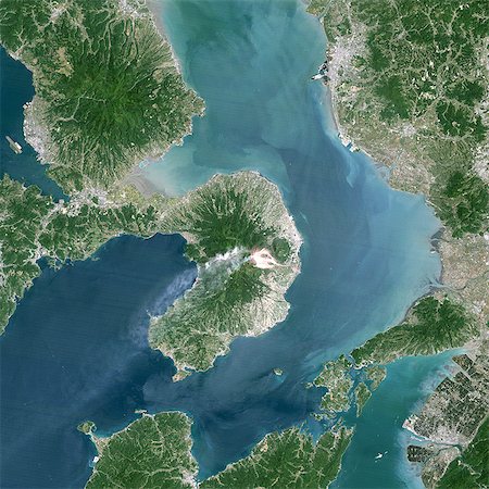
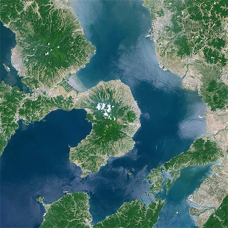
Usu Volcano, Japan, True Colour Satellite Image. Usu Volcano, Japan, true colour satellite image. Usu is a volcano (737m) located on the Southern rim of Lake Toya on Hokkaido island. Image taken on 9 August 1999 using LANDSAT data. Print size 30 x 30 cm.
Rights-Managed
-
Unzen Volcano In 1993, Japan, True Colour Satellite Image. Unzen volcano, Japan, true colour satellite image. Unzen is an active volcano located on the Island of Kyushu, East of Nagasaki. The image was taken 2 years after an eruption that occurred in 1991. Image taken on 15 May 1993 using LANDSAT data. Print size 30 x 30 cm.
Rights-Managed
-
Unzen Volcano In 2001, Japan, True Colour Satellite Image. Unzen volcano, Japan, true colour satellite image. Unzen volcano is located on the Island of Kyushu, East of Nagasaki. The image was taken 10 years after an eruption that occurred in 1991. Image taken on 13 May 2001 using LANDSAT data. Print size 30 x 30.
Rights-Managed
-

-

Kelimutu Volcano, Indonesia, True Colour Satellite Image. Kelimutu volcano, Indonesia, true colour satellite image. Located in central Flores, is the summit of Mount Kelimutu (1639m), with three coloured lakes. Image taken on 4 June 1991 using LANDSAT data. Print size 30 x 30 cm.
Rights-Managed
-
Bromo Volcano, Java Island, Indonesia, True Colour Satellite Image. Java, Indonesia, true colour satellite image. Different volcanoes are located in the 16km-wide Tengger caldera : Bromo (2329m), at the North of this view, and Semeru (3676m), a very active volcano. Image taken on 20 August 1991 using LANDSAT data. Print size 30 x 30 cm.
Rights-Managed
-
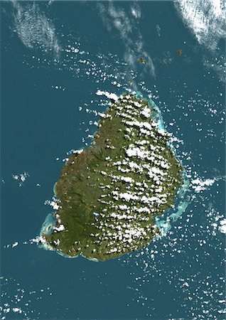
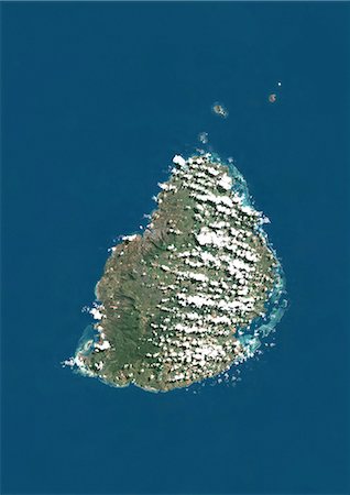
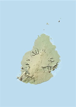
Mauritius, True Colour Satellite Image. Mauritius, true colour satellite image, taken on 19 August 1999, by the LANDSAT 7 satellite.
Rights-Managed
-
Mayotte, Africa, True Colour Satellite Image. Satellite view of Mayotte, an overseas collectivity of France, in the northern Mozambique Channel in the Indian Ocean. This image was compiled from data acquired by LANDSAT 5 & 7 satellites.
Rights-Managed
-

Long Island Volcano In 3D, Papua New Guinea, True Colour Satellite Image. Long Island, Papua New Guinea, true colour satellite image. 3D satellite view of Long Island volcano in the Bismark Sea, Papua New Guinea. This volcano contains a large caldera filled by Lake Wisdom. Image using LANDSAT data.
Rights-Managed
-
Yasur Volcano, Vanuatu, Pacific, True Colour Satellite Image. Yasur volcano, Vanuatu, true colour satellite image. Yasur (365m) is a small active volcano on Tanna island, in Vanuatu. Composite image dated 1999-2000 using LANDSAT data. Print size 30 x 30 cm.
Rights-Managed
-

Ambrym Volcano, Vanuatu, Pacific, True Colour Satellite Image. Ambrym Island, Vanuatu, true colour satellite image. Ambrym volcano is a large shield volcano with a 12km-wide caldera, with two active cones, Mont Benbow and Mont Maroum. Image taken on 12 September 1999 using LANDSAT data. Print size 30 x 30 cm.
Rights-Managed
-

Hekla Volcano, Iceland, True Colour Satellite Image. Hekla, Iceland, true colour satellite image. Hekla (1491m), in South Iceland, is the most famous volcano of the island. Image taken on 20 August 2000 using LANDSAT data. Print size 30 x 30 cm.
Rights-Managed
-

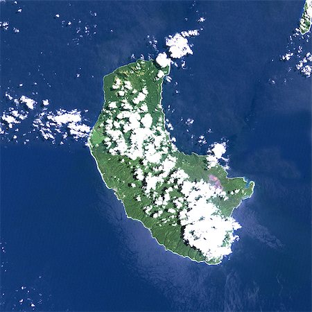
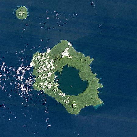
Niuafo'Ou Volcano, Tonga Islands, True Colour Satellite Image. Niuafo'ou volcano, Tonga, true colour satellite image. Niuafo'ou (250m) is an active volcano located in the Tonga archipelago. Image taken on 28 January 2000 using LANDSAT data. Print size 30 x 30 cm.
Rights-Managed
-
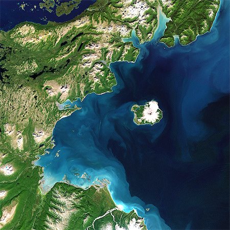
Long Island Volcano, Papua New Guinea, True Colour Satellite Image. Long Island volcano, Papua New Guinea, true colour satellite image. Long Island volcano is in the Bismark Sea, in Papua New Guinea. This volcano contains a large caldera filled by Lake Wisdom. Image taken on 31 March 1991 using LANDSAT data. Print size 30 x 30 cm.
Rights-Managed
-

Karkar Volcano, Papua New Guinea, True Colour Satellite Image. Karkar volcano, Papua New Guinea, true colour satellite image. Karkar is a volcanic island of Papua New Guinea, North West of Long Island. Image taken on 14 August 2000 using LANDSAT data. Image taken on 20 February 2000 using LANDSAT data. Print size 30 x 30 cm.
Rights-Managed
-

White Island Volcano'S Smoke Plume, New Zealand, True Colour Satellite Image. White Island volcano, New Zealand, true colour satellite image. White Island (312m) is an uninhabited volcanic island, 2 km wide, located 50 km off the coast of North Island in New Zealand. The plume contains smoke and ash. Image taken on 14 August 2000 using LANDSAT data. Print size 30 x 30 cm.
Rights-Managed
-

Surtsey Volcano, Iceland, True Colour Satellite Image. Surtsey volcano, Iceland, true colour satellite image. Surtsey is a volcanic island, South of Iceland. Composite image dated 1994-2001 using LANDSAT data. Print size 30 x 30 cm.
Rights-Managed
-

Mauna Loa Volcano, Hawai, Usa, True Colour Satellite Image. Mauna Loa, Hawai, true colour satellite image. Mauna Loa (4170m), one of the tallest mountains in the world, is located on the Big Island of Hawai. Composite image dated 2000-2001 using LANDSAT data. Print size 30 x 30 cm.
Rights-Managed
-

-
Augustine Volcano, Alaska, Usa, True Colour Satellite Image. Augustine Volcano, Alaska, true colour satellite image. Augustine is a volcano 1227 m high conical-shaped island stratovolcano located in Alaska's Cook Inlet. Image taken on 16 August 2000 using LANDSAT data. Print size 30 x 30 cm.
Rights-Managed
-

-

Mount Pelee, Martinique, France, True Colour Satellite Image. Mount Pelée, true colour satellite image. Mount Pelée is the only active volcano on the Carribean Island of Martinique, it overlooks the town of Saint-Pierre. Image taken on 4 January 2001 using LANDSAT data.
Rights-Managed
-
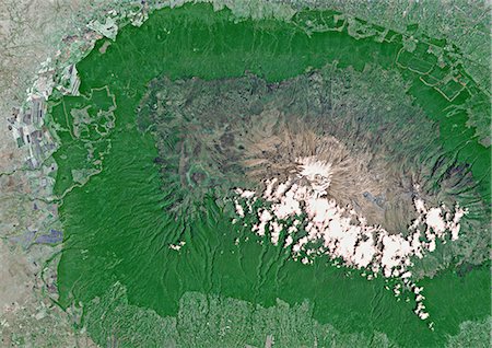
Kilimandjaro, Tanzania, True Colour Satellite Image. Portions of Kenya and Tanzania, Africa, can be seen in this image. The peak of Kilimanjaro is on the right; the mountain is flanked by the plains of Amboseli National Park to the north and the rugged Arusha National Park to the south and west. Image taken on 25 February 1987 using LANDSAT data.
Rights-Managed
-

Fogo Island, Cape Verde, True Colour Satellite Image. Satellite image of Fogo Island, Cape Verde. Fogo is a volcanic island in Cape Verde. It is rising to 2829m above sea level at Mount Fogo. Image taken on 20 September 1999 using LANDSAT data.
Rights-Managed
-
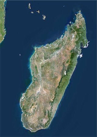
Madagascar, True Colour Satellite Image. Madagascar, true colour satellite image. This image was compiled from data acquired by LANDSAT 5 & 7 satellites.
Rights-Managed
-

Mount St Helens, Washington State, Us, In 1999, True Colour Satellite Image. True colour satellite image of Mount St-Helens, an active vulcanoe (2250m high) in Washington State, US. Image taken on 7 September 1999, after its catastrophic eruption of 1980, using LANDSAT data.
Rights-Managed
-
Mount St Helens, Washington State, Us, In 1972, True Colour Satellite Image. True colour satellite image of Mount St-Helens, an active vulcanoe (2250m high) in Washington State, US. Image taken on 29 July 1972, before its catastrophic eruption of 1980, using LANDSAT data.
Rights-Managed
-

Tanzania, Africa, True Colour Satellite Image With Mask. Satellite view of Tanzania (with mask). This image was compiled from data acquired by LANDSAT 5 & 7 satellites.
Rights-Managed
-
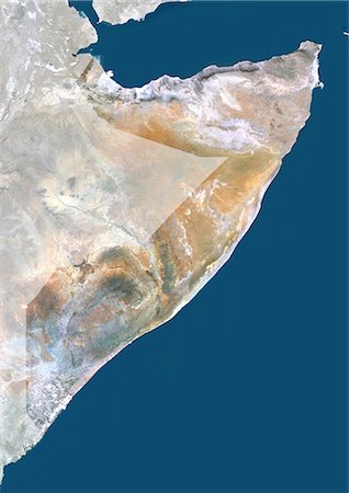
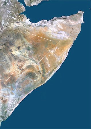
Somalia, Africa, True Colour Satellite Image With Mask. Satellite view of Somalia (with mask). This image was compiled from data acquired by LANDSAT 5 & 7 satellites.
Rights-Managed
-
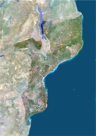
Mozambique, Africa, True Colour Satellite Image With Mask. Satellite view of Mozambique (with mask). This image was compiled from data acquired by LANDSAT 5 & 7 satellites.
Rights-Managed
-
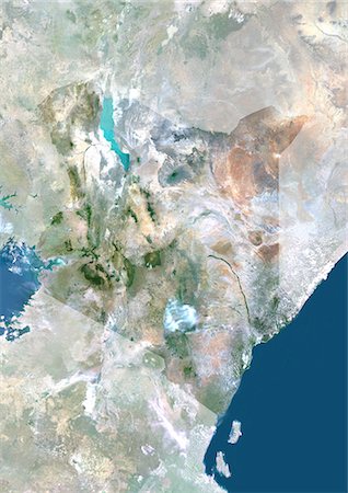
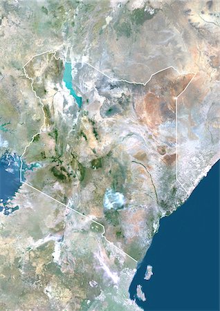
Kenya, Africa, True Colour Satellite Image With Mask. Satellite view of Kenya (with mask). This image was compiled from data acquired by LANDSAT 5 & 7 satellites.
Rights-Managed
-

Tanzania, Africa, True Colour Satellite Image With Border And Mask. Satellite view of Tanzania (with border and mask). This image was compiled from data acquired by LANDSAT 5 & 7 satellites.
Rights-Managed
-

Tanzania, Africa, True Colour Satellite Image With Border. Satellite view of Tanzania (with border). This image was compiled from data acquired by LANDSAT 5 & 7 satellites.
Rights-Managed
-

Somalia, Africa, True Colour Satellite Image With Border And Mask. Satellite view of Somalia (with border and mask). This image was compiled from data acquired by LANDSAT 5 & 7 satellites.
Rights-Managed
-
Somalia, Africa, True Colour Satellite Image With Border. Satellite view of Somalia (with border). This image was compiled from data acquired by LANDSAT 5 & 7 satellites.
Rights-Managed
-

Mozambique, Africa, True Colour Satellite Image With Border And Mask. Satellite view of Mozambique (with border and mask). This image was compiled from data acquired by LANDSAT 5 & 7 satellites.
Rights-Managed
-

Mozambique, Africa, True Colour Satellite Image With Border. Satellite view of Mozambique (with border). This image was compiled from data acquired by LANDSAT 5 & 7 satellites.
Rights-Managed
-
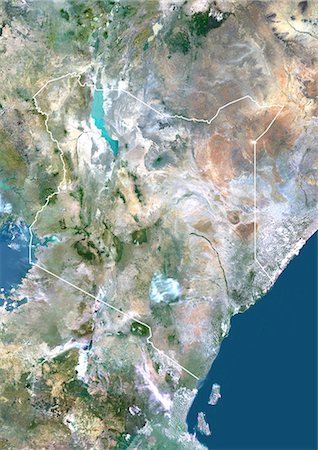
Kenya, Africa, True Colour Satellite Image With Border And Mask. Satellite view of Kenya (with border and mask). This image was compiled from data acquired by LANDSAT 5 & 7 satellites.
Rights-Managed
-
Kenya, Africa, True Colour Satellite Image With Border. Satellite view of Kenya (with border). This image was compiled from data acquired by LANDSAT 5 & 7 satellites.
Rights-Managed
-

Cape Verde, Africa, True Colour Satellite Image. Satellite view of the Cape Verde archipelago. This image was compiled from data acquired by LANDSAT 5 & 7 satellites.
Rights-Managed
-
Vredefort Meteor Impact Crater, South Africa, True Colour Satellite Image. True colour satellite image of Vredefort impact structure, South Africa (diameter : 140 km). Composite image of LANDSAT data taken on 7 April 1991 and 30 April 1991.
Rights-Managed
-
Tin Bider Meteor Impact Crater, Algeria, True Colour Satellite Image. True colour satellite image of Tin Bider impact structure, Algeria (age : 70 million years ; diameter : 6 km). Image taken on 19 February 1988 using LANDSAT data.
Rights-Managed
-

Talemzane Meteor Impact Crater, Algeria, True Colour Satellite Image. True colour satellite image of Talemzane impact structure, Algeria (age : 3 million years ; diameter : 1,75 km). Image taken on 3 March 1987 using LANDSAT data.
Rights-Managed
-

Saltpan Meteor Impact Crater, Pretoria, South Africa, True Colour Satellite Image. True colour satellite image of Saltpan impact structure, Pretoria, South Africa (diameter : 1,13 km). Image taken on 7 September 1991 using LANDSAT data.
Rights-Managed
-
Meteor Impact Crater, Libya, True Colour Satellite Image. True colour satellite image of an impact structure North of Koufra Oasis (24 06'N - 23 24'E), in the Libyan desert. Image taken on 9 November 1986 using LANDSAT data.
Rights-Managed
-
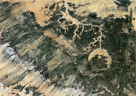
Gweni Fada Meteor Impact Crater, Chad, True Colour Satellite Image. True colour satellite image of Gweni-Fada impact structure, Chad (diameter : 14 km). Image taken on 19 January 1987 using LANDSAT data.
Rights-Managed
-

Meteor Impact Crater In The Libyan Desert, Egypt, True Colour Satellite Image. True colour satellite image of an impact structure in the Libyan desert, Egypt. Image taken on 9 November 1986 using LANDSAT data.
Rights-Managed
-

Bosumtwi Meteor Impact Crater, Ghana, True Colour Satellite Image. True colour satellite image of Bosumtwi impact structure, Ghana (diameter : 10,5 km). Composite image of LANDSAT data taken on 11 January 1986 and 29 December 1986.
Rights-Managed
-

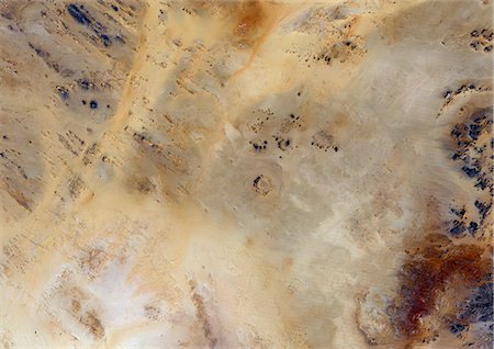
Aouelloul Meteor Impact Crater, Mauritania, True Colour Satellite Image. True colour satellite image of Aouelloul impact structure, Mauritania (diameter : 390 m). Image taken on 13 January 1987 using LANDSAT data.
Rights-Managed
-

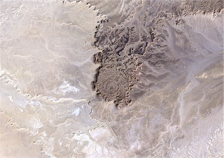
Aorounga Meteor Impact Crater, Chad, True Colour Satellite Image. True colour satellite image of Aorounga impact structure, Chad (age : 200 million years ; diameter : 17 km). Image taken on 22 February 1988 using LANDSAT data.
Rights-Managed
-

Amguid Meteor Impact Crater, Algeria, True Colour Satellite Image. True colour satellite image of Amguid impact structure, Algeria (age : 100 000 years ; diameter : 450 m). Image taken on 19 February 1988 using LANDSAT data.
Rights-Managed
-
Mount St Helens In 3D, South View, Washington State, Usa. Mount St-Helens, USA, true colour satellite image. South view of Mount St-Helens in 3D, an active volcano (2250m high) in Washington State, US. Image using LANDSAT data.
Rights-Managed
-
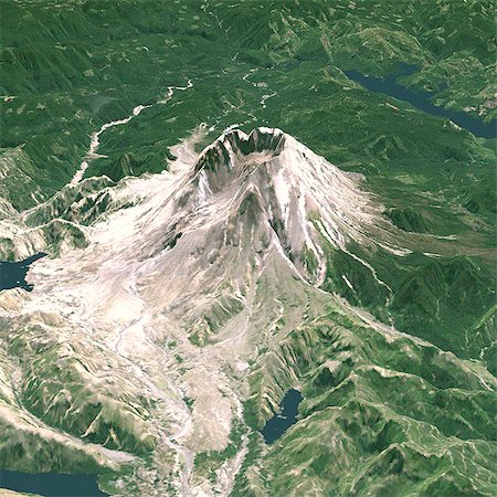
Mount St Helens In 3D, North West View, Washington State, Usa, True Colour Satellite Image. Mount St-Helens, USA, true colour satellite image. North-West view of Mount St-Helens in 3D, an active volcano (2250m high) in Washington State, US. Image using LANDSAT data. Print size 30 x 30 cm.
Rights-Managed
-

Santa Maria Volcano, Guatemala, True Colour Satellite Image. Santa Maria volcano, Guatemala, true colour satellite image. Santa Maria is a volcano (3770m) located South of the city of Quetzaltenango, in Guatemala. Composite image dated 2000 using LANDSAT data. Print size 30 x 30 cm.
Rights-Managed
-

Poas Volcano, Costa Rica, True Colour Satellite Image. Poas, Poas National Park, Costa Rica, true colour satellite image. Poas is a volcano (2700 m) that combines two large crater lakes, one being an acid crater lake. Image taken on 6 February 1986 using LANDSAT data. Print size 30 x 30 cm.
Rights-Managed
-

Nemrut Dagi Volcano, Turkey, True Colour Satellite Image. Nemrut Dagi, Turkey, true colour satellite image. Nemrut Dagi (2935m) has a large caldera whose Western end is occupied by a lake. Image taken on 5 September 2000 using LANDSAT data. Print size 30 x 30 cm.
Rights-Managed
-
Karymsky Volcano, Russia, True Colour Satellite Image. Karymsky volcano, Russia, true colour satellite image. Karymsky (1496m) is a young and active volcano. Its summit appears on the image under clouds, North of Caldera Lake. In the North-East is the active volcano, Maly Semiachik, and its a bright blue crater lake. Image taken on 30 July 2001 using LANDSAT data. Print size 30 x 30 cm.
Rights-Managed
-

Popocatepetl Volcano, Mexico, True Colour Satellite Image. Popocatepetl volcano, Mexico, true colour satellite image. The Popocatepetl (5465m) is located 60 km South East of Mexico city. Image taken on 7 March 1989 using LANDSAT data. Print size 30 x 30 cm.
Rights-Managed
-
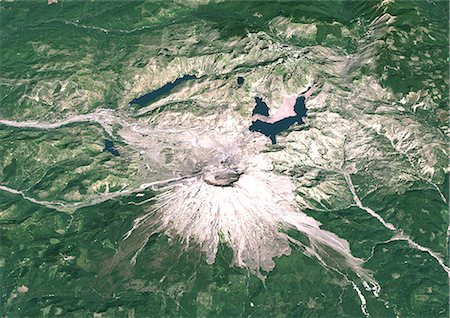
Mount Etna In 1999, Italy, True Colour Satellite Image. Mount Etna, Sicily, Italy, true colour satellite image. Mount Etna, the highest active volcano in Europe, situated North-East of Sicily, 3350m high. Image taken on 26 September 1999 using LANDSAT data. Print size 30 x 30 cm.
Rights-Managed
-

Mount Etna'S Smoke Plume In 1987, Italy, True Colour Satellite Image. Mount Etna, Sicily, Italy, true colour satellite image. Mount Etna is the highest active volcano in Europe, situated North-East of Sicily, 3350m high. The plume, kilometres high, contains smoke and ash. Image taken on 13 June 1987 using LANDSAT data. Print size 30 x 30 cm.
Rights-Managed
-

Damavand Volcano, Iran, True Colour Satellite Image. Damavand volcano, Iran, true colour satellite image. Damavand is a volcano (5671m) located 50km North-East of Tehran, in the Alborz Mountain Range, in Northern Iran. Image taken on 19 September 1988 using LANDSAT data. Print size 30 x 30 cm.
Rights-Managed
-

Cotopaxi Volcano, Ecuador, True Colour Satellite Image. Cotopaxi volcano, Ecuador, true colour satellite image. 40km South-East of Quito, Cotopaxi (5897m) is one of the most dangerous volcanoes of Ecuador. Composite image dated 1999-2001 using LANDSAT data. Print size 30 x 30 cm.
Rights-Managed
-

Villarica Volcano, Chile, True Colour Satellite Image. Villarrica volcano, Chile, true colour satellite image. Villarrica (2847m) is the most active volcano in Chile. It appears at the center of the image, covered by an ice cap. Image taken on 29 November 2001 using LANDSAT data. Print size 30 x 30 cm.
Rights-Managed
-

Volcano Tousside In 3D, Chad, True Colour Satellite Image. Pic Tousside, Chad, true colour satellite image. A recent volcano, known as the Pic Tousside, in the Tibesti Mountains in Northwestern tip of Chad (Africa). Composite image dated 2000-2002 using LANDSAT data.
Rights-Managed
-

Volcano Erta-Ale In 3D, Ethiopia, True Colour Satellite Image. Erta Ale, Ethiopia, true colour satellite image. Erta Ale is a very isolated basaltic shield volcano and most active volcano in Ethiopia in the Danakil depression, close to the border with Erythrea. Image taken on 5 February 2002 using LANDSAT data.
Rights-Managed
-

Mount St Helens, Washington State, Usa, True Colour Satellite Image. Mount St-Helens, true colour satellite image. Mount St-Helens is an active vulcanoe (2250m high) in Washington State. Image taken on 21 February 2000 using LANDSAT data.
Rights-Managed
-

-

Satellite view of Tenerife, Canary Islands, Spain. It is the largest and most populous island of the seven Canary Islands. Volcano Mount Teide at center is the highest point of Spain, at 3718 m. This image was compiled from data acquired by Landsat 8 satellite in 2014.
Rights-Managed
-
-
-

Kerkennah Islands, Tunisia, True Colour Satellite Image. True colour satellite image of Kerkennah Islands, a group of islands lying off the East coast of Tunisia in the Gulf of Gabes. Image taken on 21 March 2001 using LANDSAT 7 data.
Rights-Managed
-
Djerba, Tunisia, True Colour Satellite Image. True colour satellite image of Djerba, an island located in the Gulf of Gabes off the coast of Tunisia. At the bottom of the image is Tunisia mainlain. Image taken on 13 December 1999 using LANDSAT 7 data.
Rights-Managed
-

Indonesia, Asia, True Colour Satellite Image With Mask. Satellite view of Indonesia (with mask). This image was compiled from data acquired by LANDSAT 5 & 7 satellites.
Rights-Managed
-
Sao Tome And Principe, Africa, True Colour Satellite Image. Satellite view of Sao Tome and Principe islands. This image was compiled from data acquired by LANDSAT 5 & 7 satellites.
Rights-Managed
-
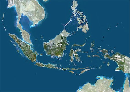
Indonesia, Asia, True Colour Satellite Image With Border And Mask. Satellite view of Indonesia (with border and mask). This image was compiled from data acquired by LANDSAT 5 & 7 satellites.
Rights-Managed
-
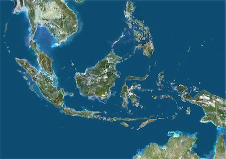
Indonesia, Asia, True Colour Satellite Image With Border. Satellite view of Indonesia (with border). This image was compiled from data acquired by LANDSAT 5 & 7 satellites.
Rights-Managed


