-
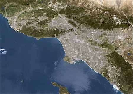
Los Angeles, California, Usa, True Colour Satellite Image. Los Angeles, California, USA. True colour satellite image of the city of Los Angeles. Composite of 2 images taken on 24 April & 1 May 2000, using LANDSAT 7 data.
Rights-Managed
-

Channel Islands Of California, Usa, True Colour Satellite Image. True colour satellite image of Channel Islands of California, a chain of eight islands located in the Pacific Ocean off the coast of Southern California. In the upper right corner is the city of Los Angeles. Image taken in Spring 2000 using LANDSAT 7 data.
Rights-Managed
-
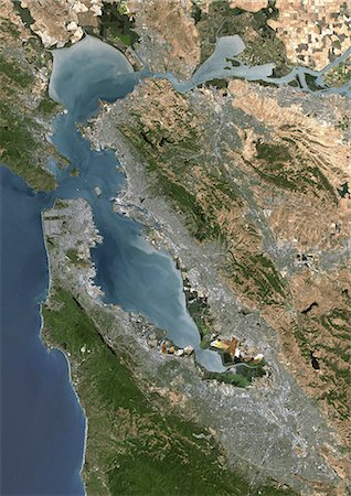
San Francisco, California, Usa, True Colour Satellite Image. San Francisco, California, USA. True colour satellite image of the city of San Francisco, taken on 7 July 1999 using LANDSAT 7 data.
Rights-Managed
-
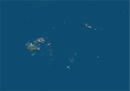
Fiji, Samoa, Tonga, Wallis And Futuna, Oceania, True Colour Satellite Image. Satellite view of Fiji, Samoa, Tonga, Wallis and Futuna Islands. This image was compiled from data acquired by LANDSAT 5 & 7 satellites.
Rights-Managed
-

Woman on Side of Highway with Map, Pacific Coast Highway, California, USA
Rights-Managed
-

Palau, Micronesia, Oceania, True Colour Satellite Image. Satellite view of Palau, Micronesia, in the North Pacific ocean. This image was compiled from data acquired by LANDSAT 5 & 7 satellites.
Rights-Managed
-
Society Islands, French Polynesia, French Overseas, Oceania, True Colour Satellite Image. Satellite view of Society Islands, a group of islands part of French Polynesia, an overseas collectivity of France in the South Pacific. This image was compiled from data acquired by LANDSAT 5 & 7 satellites.
Rights-Managed
-
Marshall Islands And Kiribati, Micronesia, Oceania, True Colour Satellite Image. Satellite view of the Marshall Islands and Kiribati, located in the Pacific ocean. This image was compiled from data acquired by LANDSAT 5 & 7 satellites.
Rights-Managed
-

Korea And Japan, True Colour Satellite Image. Korea & Japan, true colour satellite image. This image was compiled from data acquired by LANDSAT 5 & 7 satellites.
Rights-Managed
-

Japan, True Colour Satellite Image With Mask. Japan, true colour satellite image with mask. Japan is an archipelago of islands in the northern Pacific Ocean. Japan's capital city, Tokyo (grey, right centre), is situated on Japan's main island, Honshu. Japan's second largest island, Hokkaido, lies to the north of Honshu. This image was compiled from data acquired by LANDSAT 5 & 7 satellites.
Rights-Managed
-

Blank Canadian regional map in orthographic projection.
Budget Royalty-Free & Subscription
-

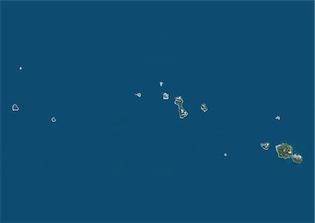
Tuvalu, Polynesia, Oceania, True Colour Satellite Image. Satellite view of Tuvalu, a Polynesian island located in the Pacific Ocean. This image was compiled from data acquired by LANDSAT 5 & 7 satellites.
Rights-Managed
-

Japan, True Colour Satellite Image. Japan, true colour satellite image. Japan is an archipelago of islands in the northern Pacific Ocean. Japan's capital city, Tokyo (grey, right centre), is situated on Japan's main island, Honshu. Japan's second largest island, Hokkaido, lies to the north of Honshu. This image was compiled from data acquired by LANDSAT 5 & 7 satellites.
Rights-Managed
-

Los Angeles, California, vintage 1920s map (printed in 1926 - copyrights expired) with a red pushpin, selective focus
Budget Royalty-Free & Subscription
-
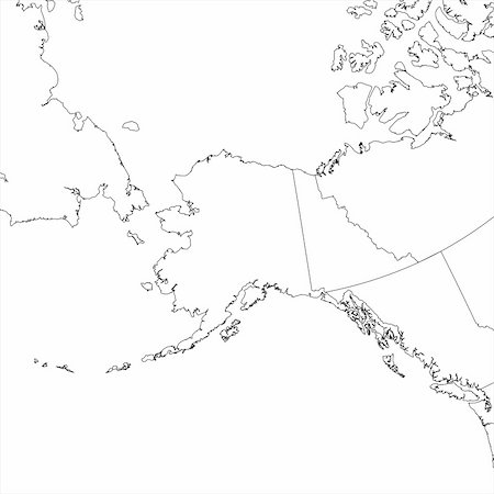
Blank Alaskan regional map in orthographic projection.
Budget Royalty-Free & Subscription
-
-

-
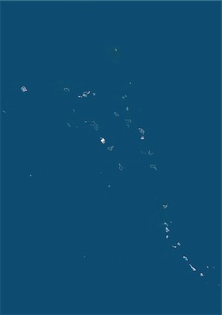
Vanuatu And Solomon Islands, Melanesia, Oceania, True Colour Satellite Image. Satellite view of Vanuatu and Solomon islands located in the South Pacific Ocean. This image was compiled from data acquired by LANDSAT 5 & 7 satellites.
Rights-Managed
-

-
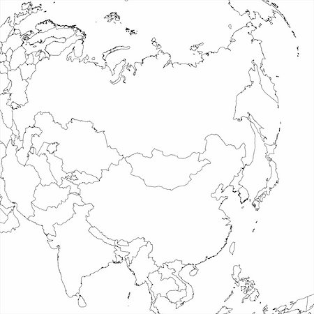
Blank Asian regional map in orthographic projection.
Budget Royalty-Free & Subscription
-
-

-

-
-

-
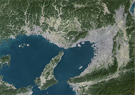
Osaka, Japan, True Colour Satellite Image. Osaka, Japan. True colour satellite image of the city of Osaka, taken on 15 October 2001, using LANDSAT 7 data.
Rights-Managed
-
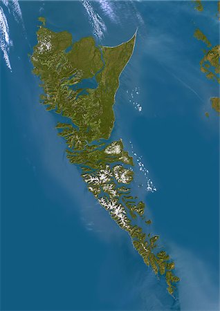
Queen Charlotte Islands, Canada, True Colour Satellite Image. True colour satellite image of Queen Charlotte Islands, an archipelago on the British Columbia Coast, Canada, in the Pacific ocean. Image using LANDSAT 7 data.
Rights-Managed
-

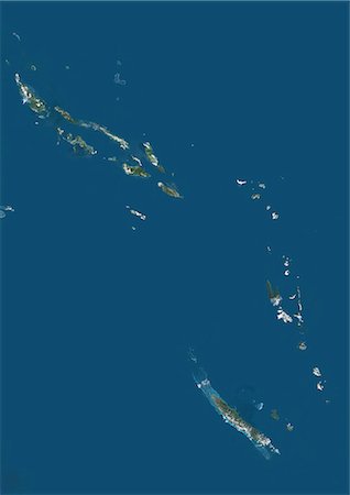
French Polynesia, Oceania, True Colour Satellite Image. Satellite view of French Polynesia. The island groups are Austral Islands, Gambier Islands, Marquesas Islands, Society Islands (including Tahiti), Tuamotu Archipelago. This image was compiled from data acquired by LANDSAT 5 & 7 satellites.
Rights-Managed
-

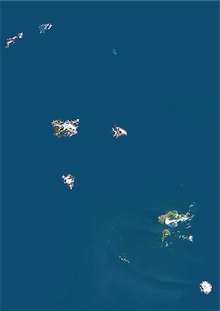
Tuamotu Archipelago And Gambier Islands, French Polynesia, French Overseas, Oceania, True Colour Satellite Image. Satellite view of the Tuamotu Archipelago, a chain of atolls in French Polynesia, and of the Gambier Islands, located at the southeast terminus of the Tuamotu archipelago. This image was compiled from data acquired by LANDSAT 5 & 7 satellites.
Rights-Managed
-
Marquesas Islands, French Polynesia, French Overseas, Oceania, True Colour Satellite Image. Satellite view of Marquesas islands, a group of volcanic islands in French Polynesia, an overseas collectivity of France in the southern Pacific Ocean. This image was compiled from data acquired by LANDSAT 5 & 7 satellites.
Rights-Managed
-

Ecuador with surrounding region as seen from Earth's orbit in space. 3D illustration with highly detailed planet surface and clouds in the atmosphere. Elements of this image furnished by NASA.
Budget Royalty-Free & Subscription


