-
-

-

-

-

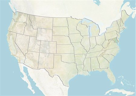
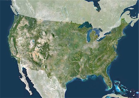
United States and the State of Western Virginia, True Colour Satellite Image
Rights-Managed
-

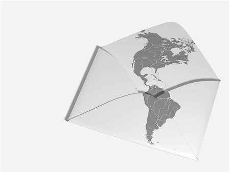
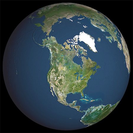
Glass Globe illustrating North and South America, Europe, Russia and Africa
Premium Royalty-Free
-

-
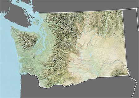
Relief map of the State of Washington, United States. This image was compiled from data acquired by LANDSAT 5 & 7 satellites combined with elevation data.
Rights-Managed
-

Great Lakes, North America, True Colour Satellite Image. True colour satellite image of the Great Lakes region which includes the Canadian Province of Ontario and eight US states. Lakes are from west to east : Lake Superior, Lake Michigan, Lake Huron, Lake Erie and Lake Ontario. Composite image using LANDSAT 5 data.
Rights-Managed
-
-
-
-

Glass Globe illustrating North and South America, Europe, Russia and Africa
Premium Royalty-Free
-
-

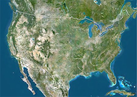
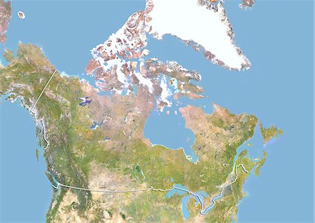
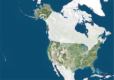
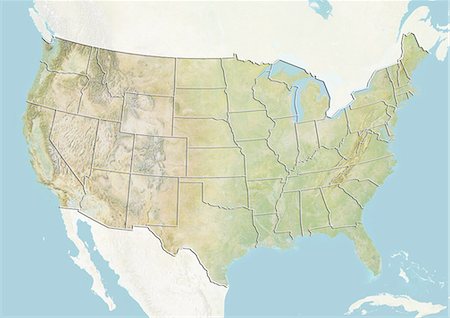
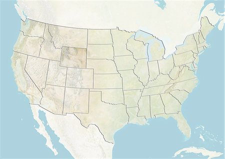
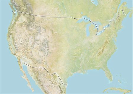
Relief map of the United States and Canada (with border). This image was compiled from data acquired by LANDSAT 5 & 7 satellites combined with elevation data.
Rights-Managed
-
-

North America At Night, True Colour Satellite Image. True colour satellite image of North America at night. This image in Lambert Conformal Conic projection was compiled from data acquired by LANDSAT 5 & 7 satellites.
Rights-Managed
-
-
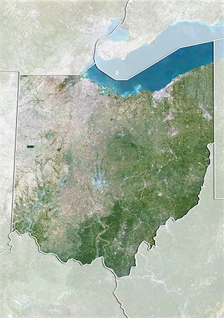
Satellite view of the State of Ohio, United States. This image was compiled from data acquired by LANDSAT 5 & 7 satellites.
Rights-Managed
-

Globe Showing Asia, True Colour Satellite Image. True colour satellite image of the Earth showing Asia and the North Pole. This image in orthographic projection was compiled from data acquired by LANDSAT 5 & 7 satellites.
Rights-Managed
-

-

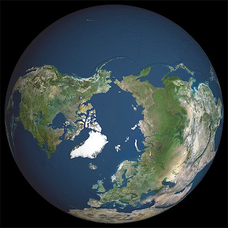
Globe Showing Northern America, True Colour Satellite Image. True colour satellite image of the Earth showing Greenland, the North Pole and Northern America. This image in orthographic projection was compiled from data acquired by LANDSAT 5 & 7 satellites.
Rights-Managed
-

-
-

-
North America With Major Rivers, True Colour Satellite Image. True colour satellite image of North America with major rivers. This image in Lambert Conformal Conic projection was compiled from data acquired by LANDSAT 5 & 7 satellites.
Rights-Managed
-

-

-

-
-

Satellite view of Puerto Rico. This image was compiled from data acquired by Landsat satellites.
Rights-Managed
-

-
-
-

-

-
-
-

Relief map of the State of California, United States. This image was compiled from data acquired by LANDSAT 5 & 7 satellites combined with elevation data.
Rights-Managed
-

-

Satellite view of Newfoundland and Labrador, Canada. This image was compiled from data acquired by LANDSAT 5 & 7 satellites.
Rights-Managed
-

-
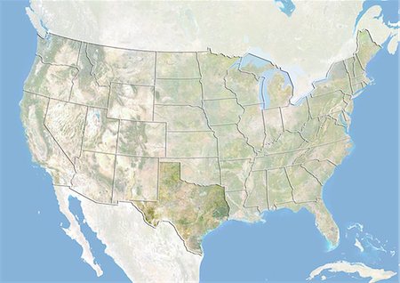
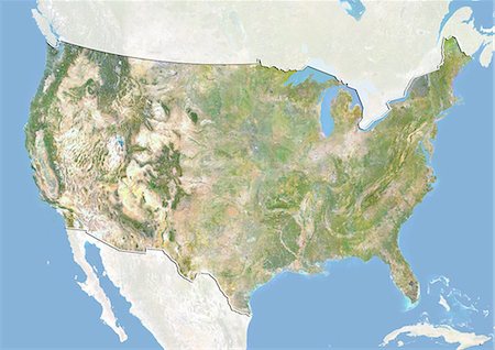
United States, True Colour Satellite Image With Mask. USA, true colour satellite image with mask. This image was compiled from data acquired by LANDSAT 5 & 7 satellites.
Rights-Managed
-

-
-

Globe Showing The Americas, True Colour Satellite Image. True colour satellite image of the Earth showing the Americas, half in shadow, and the sun. This image in orthographic projection was compiled from data acquired by LANDSAT 5 & 7 satellites.
Rights-Managed
-

North America With Cloud Coverage, True Colour Satellite Image. True colour satellite image of North America with cloud coverage. This image in Lambert Conformal Conic projection was compiled from data acquired by LANDSAT 5 & 7 satellites.
Rights-Managed
-
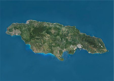
Satellite view of Jamaica. This image was compiled from data acquired by Landsat satellites.
Rights-Managed
-

Globe Centred On The Americas, True Colour Satellite Image. True colour satellite image of the Earth centred on the Americas, during winter solstice at 6 a.m GMT. This image in orthographic projection was compiled from data acquired by LANDSAT 5 & 7 satellites.
Rights-Managed
-
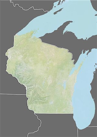
Relief map of the State of Wisconsin, United States. This image was compiled from data acquired by LANDSAT 5 & 7 satellites combined with elevation data.
Rights-Managed
-

-

Globe Centred On The Americas, True Colour Satellite Image. True colour satellite image of the Earth centred on the Americas, during summer solstice at 6 a.m GMT. This image in orthographic projection was compiled from data acquired by LANDSAT 5 & 7 satellites.
Rights-Managed
-

North America At Night With Country Borders, True Colour Satellite Image. True colour satellite image of North America at night with country borders. This image in Lambert Conformal Conic projection was compiled from data acquired by LANDSAT 5 & 7 satellites.
Rights-Managed
-

-

Satellite view of the State of Florida, United States. This image was compiled from data acquired by LANDSAT 5 & 7 satellites.
Rights-Managed
-
-

Globe Centred On The North Pole, True Colour Satellite Image. True colour satellite image of the Earth centred on the North Pole, during summer solstice at 6 p.m GMT. This image in orthographic projection was compiled from data acquired by LANDSAT 5 & 7 satellites.
Rights-Managed
-

Globe Centred On The North Pole, True Colour Satellite Image. True colour satellite image of the Earth centred on the North Pole, during summer solstice at 6 a.m GMT. This image in orthographic projection was compiled from data acquired by LANDSAT 5 & 7 satellites.
Rights-Managed
-
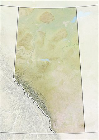
Relief map of Alberta, Canada. This image was compiled from data acquired by LANDSAT 5 & 7 satellites combined with elevation data.
Rights-Managed
-
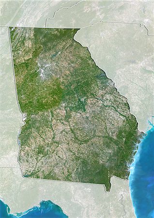
Satellite view of the State of Georgia, United States. This image was compiled from data acquired by LANDSAT 5 & 7 satellites.
Rights-Managed
-

Glass globe representing North America, Canada, Alaska and Greenland
Premium Royalty-Free
-
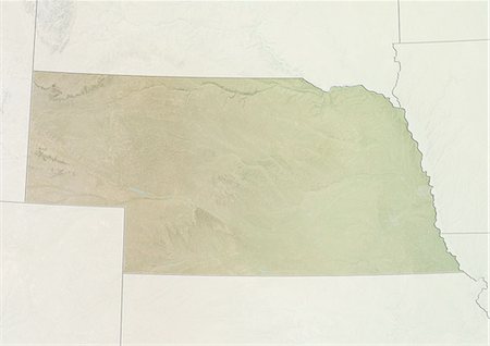
Relief map of the State of Nebraska, United States. This image was compiled from data acquired by LANDSAT 5 & 7 satellites combined with elevation data.
Rights-Managed
-
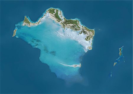
Satellite view of Turks and Caicos Islands. This image was compiled from data acquired by Landsat satellites.
Rights-Managed
-

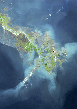
Manicouagan Crater, Quebec, Canada, True Colour Satellite Image. True colour satellite image of Manicouagan Reservoir (also Lake Manicouagan), an annular lake in northern Quebec, Canada, the remnant of an impact crater made approximately 212 million years ago, of 100 km diameter. Image taken on 1 June 2001 using LANDSAT data.
Rights-Managed
-

-

Closeup of compass laying on State of Alaska Map Still Life Alaska w/w/o Sepia
Rights-Managed
-

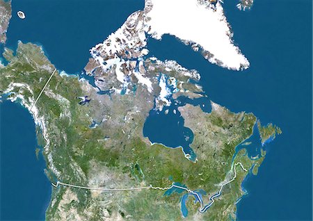
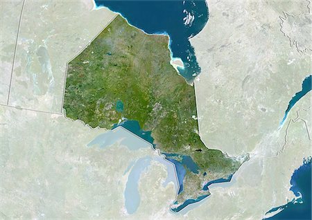
Relief map of Ontario, Canada. This image was compiled from data acquired by LANDSAT 5 & 7 satellites combined with elevation data.
Rights-Managed
-
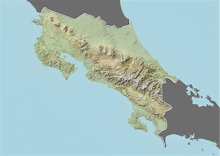
Relief map of Costa Rica (with border and mask). This image was compiled from data acquired by landsat 5 & 7 satellites combined with elevation data.
Rights-Managed
-

-
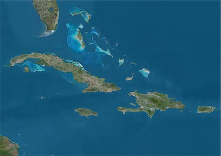
Satellite view of The Greater Antilles and Bahamas. This image was compiled from data acquired by Landsat satellites.
Rights-Managed
-

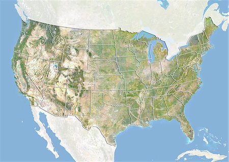
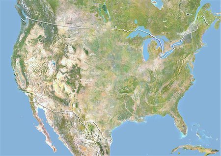
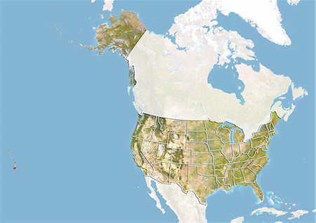
United States (Alaska Incl.), True Colour Satellite Image With Border. USA (Alaska incl.) and Canada, true colour satellite image. This image was compiled from data acquired by LANDSAT 5 & 7 satellites.
Rights-Managed
-

-

-

-

Relief map of the State of Indiana, United States. This image was compiled from data acquired by LANDSAT 5 & 7 satellites combined with elevation data.
Rights-Managed
-

Relief map of the State of Nevada, United States. This image was compiled from data acquired by LANDSAT 5 & 7 satellites combined with elevation data.
Rights-Managed
-
-
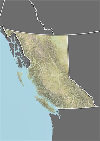
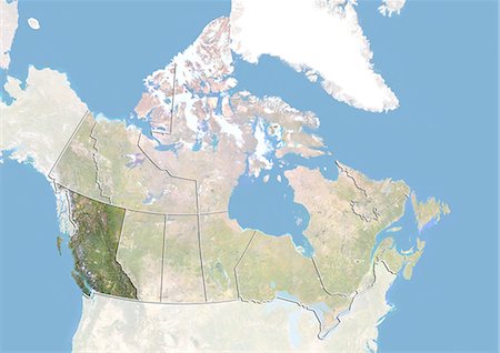
Relief map of British Columbia, Canada. This image was compiled from data acquired by LANDSAT 5 & 7 satellites combined with elevation data.
Rights-Managed
-

Caribbean Islands, True Colour Satellite Image. Caribbean Islands, true colour satellite image. This image was compiled from data acquired by LANDSAT 5 & 7 satellites.
Rights-Managed
-
-

-
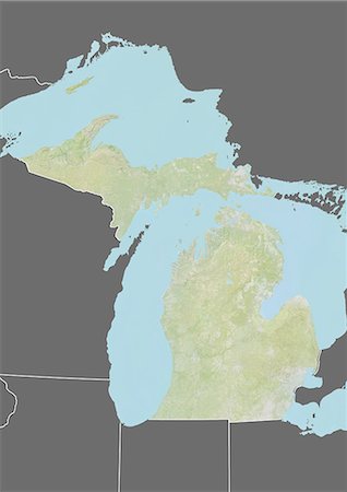
Relief map of the State of Michigan, United States. This image was compiled from data acquired by LANDSAT 5 & 7 satellites combined with elevation data.
Rights-Managed
-
-

-
-

Globe Showing Europe, True Colour Satellite Image. True colour satellite image of the Earth showing Greenland, the North Pole and Europe. This image in orthographic projection was compiled from data acquired by LANDSAT 5 & 7 satellites.
Rights-Managed
-
-
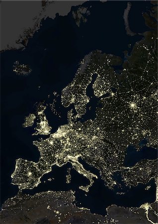
Europe At Night, True Colour Satellite Image. True colour satellite image of Europe at night. This image in Lambert Conformal Conic projection was compiled from data acquired by LANDSAT 5 & 7 satellites.
Rights-Managed
-
Satellite view of Ontario, Canada. This image was compiled from data acquired by LANDSAT 5 & 7 satellites.
Rights-Managed
-
Canada and the Province of British Columbia, Satellite Image With Bump Effect
Rights-Managed


