-
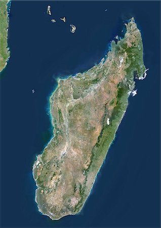
Madagascar, True Colour Satellite Image. Madagascar, true colour satellite image. This image was compiled from data acquired by LANDSAT 5 & 7 satellites.
Rights-Managed
-

-

Satellite view of Southern Africa. It shows the African Great Lakes region. This image was compiled from data acquired by Landsat 7 & 8 satellites.
Rights-Managed
-
-
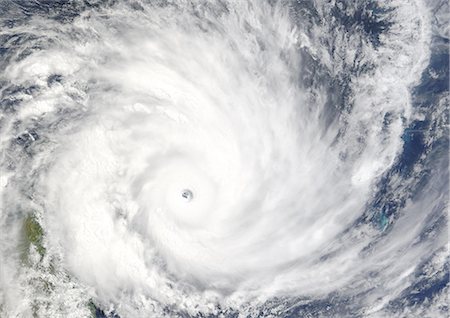
Cyclone Gafilo, Indian Ocean, In 2004, True Colour Satellite Image. Tropical Cyclone Gafilo over the Indian Ocean, Northwest of Madagascar, on 6 March 2004. True-colour satellite image using MODIS data.
Rights-Managed
-
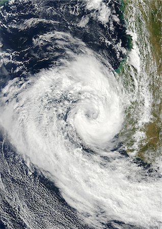
Cyclone Izilda, Madagascar, Africa, In 2009, True Colour Satellite Image. Cyclone Izilda in the Mozambique Channel off the coast of Southern Magadascar on 25 March 2009. True-colour satellite image using MODIS data.
Rights-Managed
-
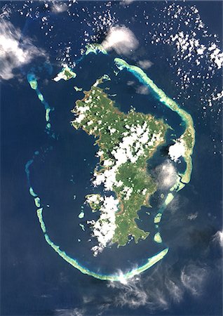
Mayotte, Africa, True Colour Satellite Image. Satellite view of Mayotte, an overseas collectivity of France, in the northern Mozambique Channel in the Indian Ocean. This image was compiled from data acquired by LANDSAT 5 & 7 satellites.
Rights-Managed
-

Diego Suarez (Antsiranana), Madagascar, True Colour Satellite Image. Antsiranana (formerly Diego Suarez), Madagascar. True colour satellite image of the city of Antsiranana, located at the northern tip of Madagascar. Image taken on 29 April 2001, using LANDSAT 7 data.
Rights-Managed
-

Africa region on planet Earth from space with stars in the background. Elements of this image furnished by NASA.
Budget Royalty-Free & Subscription
-

Color satellite image of Antananarivo, capital city of Madagascar. Image collected on May 11, 2017 by Sentinel-2 satellites.
Rights-Managed
-

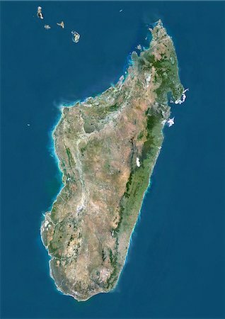
Satellite view of Madagascar. Comoros and Mayotte islands are at North. This image was compiled from data acquired by Landsat satellites.
Rights-Managed
-

-

Betsiboka River, Madagascar, True Colour Satellite Image. Betsiboka river, the major river of Madagascar, goes into the Mozambique canal, close to the city of Mahajanga.
Rights-Managed
-

Madagascar with surrounding region as seen from Earth's orbit in space. 3D illustration with highly detailed planet surface and clouds in the atmosphere. Elements of this image furnished by NASA.
Budget Royalty-Free & Subscription


