-
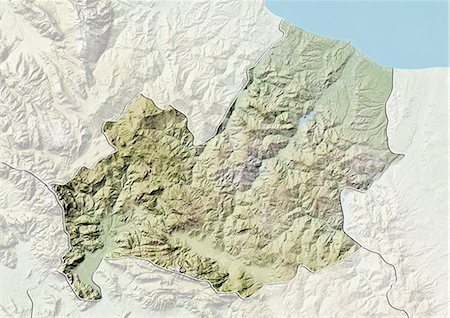
Relief map of the region of Molise, Italy. This image was compiled from data acquired by LANDSAT 5 & 7 satellites combined with elevation data.
Rights-Managed
-

Europe At Night With Country Borders, True Colour Satellite Image. True colour satellite image of Europe at night with country borders. This image in Lambert Conformal Conic projection was compiled from data acquired by LANDSAT 5 & 7 satellites.
Rights-Managed
-
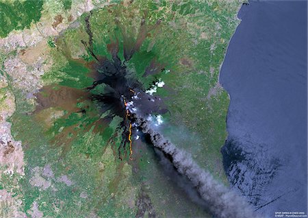
Mount Etna, Sicily, True Colour Satellite Image. Satellite image of Mount Etna, the highest active volcano in Europe, situated North-East of Sicily, 3350m high. Image taken on 23 July 2001 using LANDSAT data.
Rights-Managed
-
-

Europe At Night With Cloud Coverage, True Colour Satellite Image. True colour satellite image of Europe at night with cloud coverage. This image in Lambert Conformal Conic projection was compiled from data acquired by LANDSAT 5 & 7 satellites.
Rights-Managed
-
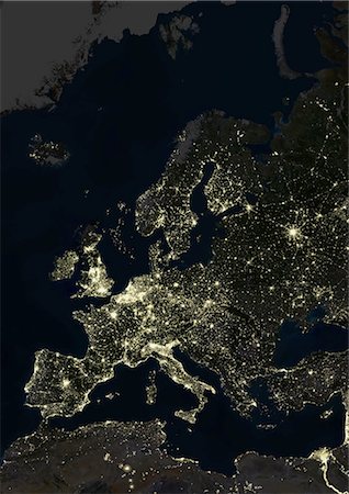
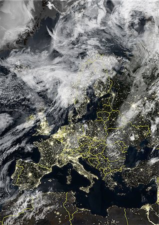
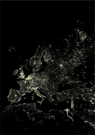
Europe At Night, True Colour Satellite Image. True colour satellite image of Europe at night. This image in Lambert Conformal Conic projection was compiled from data acquired by LANDSAT 5 & 7 satellites.
Rights-Managed
-
Mount Vesuvius, Italy, True Colour Satellite Image. True colour satellite image of Mount Vesuvius, Italy. Image taken on 2 August 2000, using LANDSAT data.
Rights-Managed
-
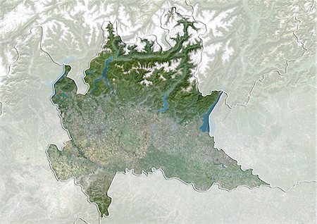
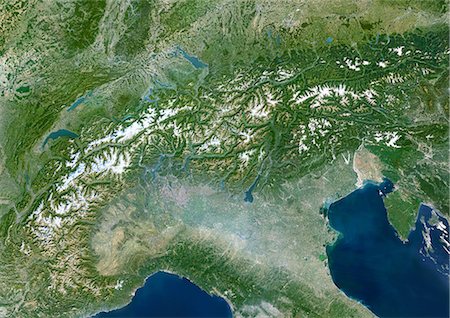
Satellite view of the region of Lombardy, Italy. This image was compiled from data acquired by LANDSAT 5 & 7 satellites.
Rights-Managed
-

Mediterranean Area, True Colour Satellite Image. Mediterranean Sea. True colour satellite images showing the Mediterranean Sea. Points of interest include the Alps (just above centre, white), the Blakek Sea (centre right), and the Nile Delta (green, lower right). This image was compiled from data acquired by LANDSAT 5 & 7 satellites.
Rights-Managed
-

Member States Of The European Union In 2007, True Colour Satellite Image With Mask And Borders. True colour satellite image of the European Union in 2007, showing the 27 member states. This image in Lambert Conformal Conic projection was compiled from data acquired by LANDSAT 5 & 7 satellites.
Rights-Managed
-
Europe At Night With Country Borders And Cloud Coverage, True Colour Satellite Image. True colour satellite image of Europe at night with country borders and cloud coverage. This image in Lambert Conformal Conic projection was compiled from data acquired by LANDSAT 5 & 7 satellites.
Rights-Managed
-
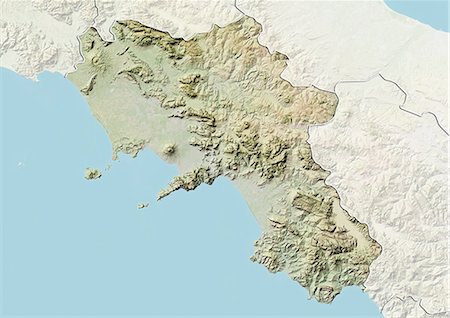
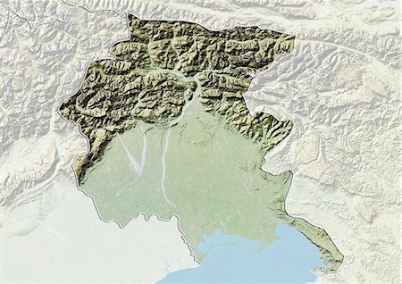
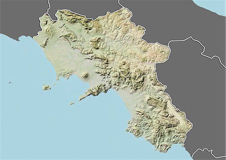
Relief map of the region of Campania, Italy. This image was compiled from data acquired by LANDSAT 5 & 7 satellites combined with elevation data.
Rights-Managed
-

-

-
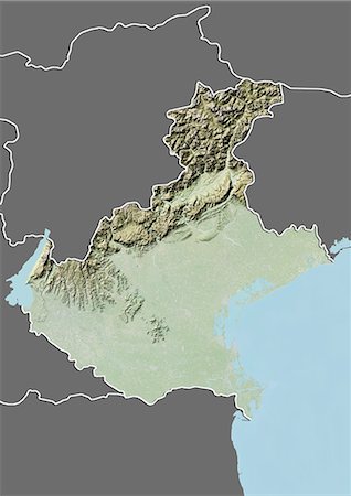
Relief map of the region of Friuli-Venezia Giulia, Italy. This image was compiled from data acquired by LANDSAT 5 & 7 satellites combined with elevation data.
Rights-Managed
-
Europe With Country Borders And Cloud Coverage, True Colour Satellite Image. True colour satellite image of Europe with country borders and cloud coverage. This image in Lambert Conformal Conic projection was compiled from data acquired by LANDSAT 5 & 7 satellites.
Rights-Managed
-

Relief map of the region of Molise, Italy. This image was compiled from data acquired by LANDSAT 5 & 7 satellites combined with elevation data.
Rights-Managed
-

-

Satellite view of the region of Friuli-Venezia Giulia, Italy. This image was compiled from data acquired by LANDSAT 5 & 7 satellites.
Rights-Managed
-

-
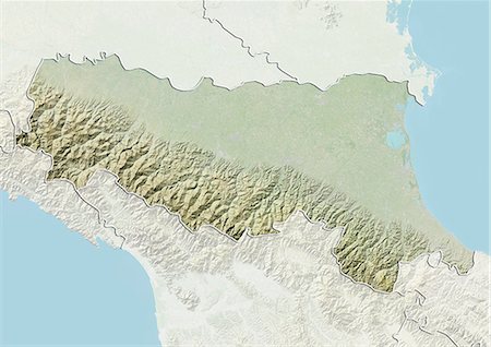
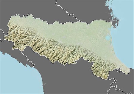
Relief map of the region of Emilia Romagna, Italy. This image was compiled from data acquired by LANDSAT 5 & 7 satellites combined with elevation data.
Rights-Managed
-

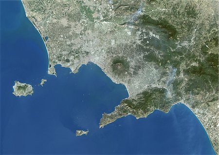
Satellite view of the region of Campania, Italy. This image was compiled from data acquired by LANDSAT 5 & 7 satellites.
Rights-Managed
-

-
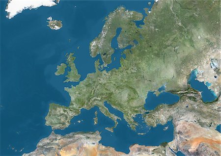
Satellite view of Europe. This image was compiled from data acquired by Landsat 7 & 8 satellites.
Rights-Managed
-

-
-

-
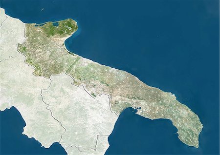
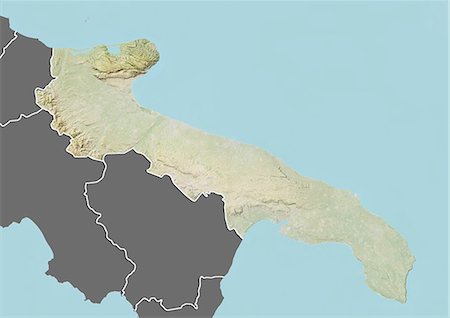
Satellite view of the region of Apulia, Italy. This image was compiled from data acquired by LANDSAT 5 & 7 satellites.
Rights-Managed
-

-
-
-

-

-
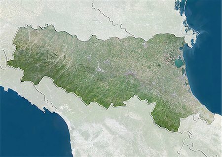
Satellite view of the region of Emilia Romagna, Italy. This image was compiled from data acquired by LANDSAT 5 & 7 satellites.
Rights-Managed
-
-
-

Relief map of the region of Veneto, Italy. This image was compiled from data acquired by LANDSAT 5 & 7 satellites combined with elevation data.
Rights-Managed
-
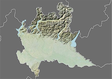
Relief map of the region of Lombardy, Italy. This image was compiled from data acquired by LANDSAT 5 & 7 satellites combined with elevation data.
Rights-Managed
-

-
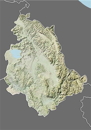
Relief map of the region of Umbria, Italy. This image was compiled from data acquired by LANDSAT 5 & 7 satellites combined with elevation data.
Rights-Managed
-

Europe With Major Rivers, True Colour Satellite Image. True colour satellite image of Europe with major rivers. This image in Lambert Conformal Conic projection was compiled from data acquired by LANDSAT 5 & 7 satellites.
Rights-Managed
-
Relief map of the region of Basilicata, Italy. This image was compiled from data acquired by LANDSAT 5 & 7 satellites combined with elevation data.
Rights-Managed
-

Satellite view of the region of Molise, Italy. This image was compiled from data acquired by LANDSAT 5 & 7 satellites.
Rights-Managed
-

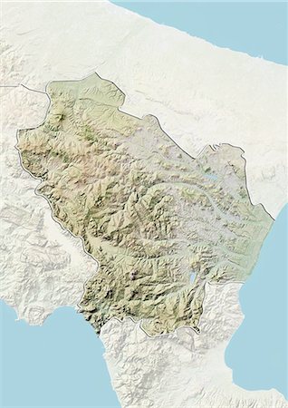
Relief map of the region of Liguria, Italy. This image was compiled from data acquired by LANDSAT 5 & 7 satellites combined with elevation data.
Rights-Managed
-

-
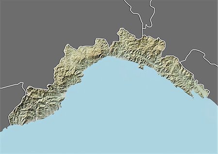
Relief map of the region of Liguria, Italy. This image was compiled from data acquired by LANDSAT 5 & 7 satellites combined with elevation data.
Rights-Managed
-

Relief map of the region of Trentino-Alto Adige, Italy. This image was compiled from data acquired by LANDSAT 5 & 7 satellites combined with elevation data.
Rights-Managed
-

Europe With Cloud Coverage, True Colour Satellite Image. True colour satellite image of Europe with cloud coverage. This image in Lambert Conformal Conic projection was compiled from data acquired by LANDSAT 5 & 7 satellites.
Rights-Managed
-
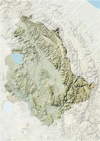
Relief map of the region of Umbria, Italy. This image was compiled from data acquired by LANDSAT 5 & 7 satellites combined with elevation data.
Rights-Managed
-

-
Relief map of the region of Campania, Italy. This image was compiled from data acquired by LANDSAT 5 & 7 satellites combined with elevation data.
Rights-Managed
-
Western Europe At Night, Satellite Image. Lights of Western Europe at night from space. Coloured image derived from satellite data showing Western Europe at night. This image is a mosaic of frames made at night by US Defense Meteorological Satellite Program (DMSP).
Rights-Managed
-

-

Relief map of the region of Abruzzo, Italy. This image was compiled from data acquired by LANDSAT 5 & 7 satellites combined with elevation data.
Rights-Managed
-

Satellite view of the region of Lazio, Italy. This image was compiled from data acquired by LANDSAT 5 & 7 satellites.
Rights-Managed
-
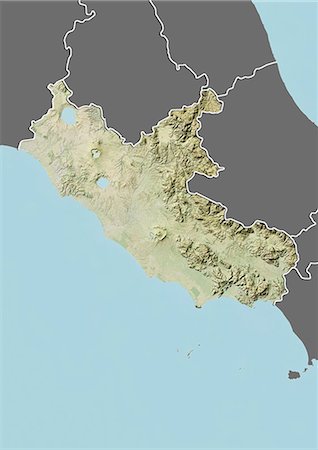
Relief map of the region of Lazio, Italy. This image was compiled from data acquired by LANDSAT 5 & 7 satellites combined with elevation data.
Rights-Managed
-

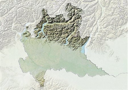
Relief map of the region of Trentino-Alto Adige, Italy. This image was compiled from data acquired by LANDSAT 5 & 7 satellites combined with elevation data.
Rights-Managed
-

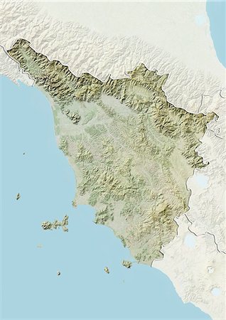
Relief map of the region of Tuscany, Italy. This image was compiled from data acquired by LANDSAT 5 & 7 satellites combined with elevation data.
Rights-Managed
-

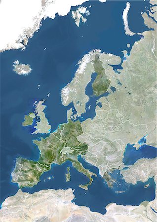
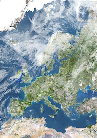
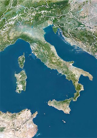
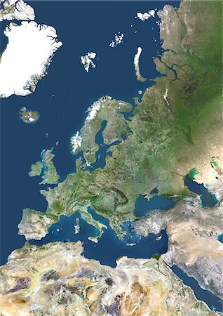
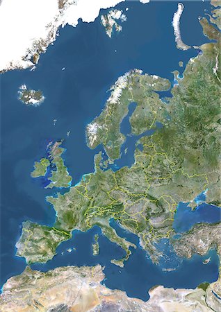
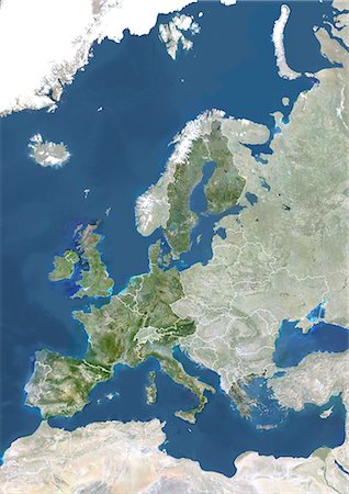
Europe, True Colour Satellite Image. True colour satellite image of Europe. This image in Lambert Conformal Conic projection was compiled from data acquired by LANDSAT 5 & 7 satellites.
Rights-Managed
-
-

-
Western Europe, True Colour Satellite Image. True colour satellite mosaic image of the whole of Europe and Scandinavia. The image used data from LANDSAT 5 & 7 satellites.
Rights-Managed
-

Relief map of the region of Lazio, Italy. This image was compiled from data acquired by LANDSAT 5 & 7 satellites combined with elevation data.
Rights-Managed
-

Relief map of the region of Friuli-Venezia Giulia, Italy. This image was compiled from data acquired by LANDSAT 5 & 7 satellites combined with elevation data.
Rights-Managed
-

-
-
Relief map of the region of Lombardy, Italy. This image was compiled from data acquired by LANDSAT 5 & 7 satellites combined with elevation data.
Rights-Managed
-
Relief map of the region of Veneto, Italy. This image was compiled from data acquired by LANDSAT 5 & 7 satellites combined with elevation data.
Rights-Managed
-

Satellite view of the region of Veneto, Italy. This image was compiled from data acquired by LANDSAT 5 & 7 satellites.
Rights-Managed
-

Italy and the Region of Emilia Romagna, Satellite Image With Bump Effect
Rights-Managed
-
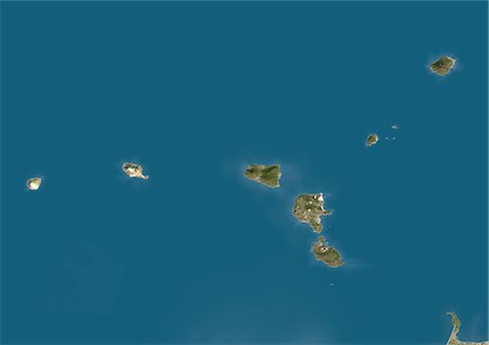
Aeolian Islands, Italy, True Colour Satellite Image. True colour satellite image of the Aeolian Islands or Lipari Islands, a volcanic archipelago in the Tyrrhenian Sea north of Sicily, Italy. The largest island is Lipari. The other islands include Vulcano, Salina, Stromboli, Filicudi, Alicudi, Panarea and Basiluzzo. Image using LANDSAT 7 data.
Rights-Managed
-
Relief map of the region of Emilia Romagna, Italy. This image was compiled from data acquired by LANDSAT 5 & 7 satellites combined with elevation data.
Rights-Managed
-

Europe With Country Borders And Major Rivers, True Colour Satellite Image. True colour satellite image of Europe with country borders and major rivers. This image in Lambert Conformal Conic projection was compiled from data acquired by LANDSAT 5 & 7 satellites.
Rights-Managed
-
Europe With Country Borders, True Colour Satellite Image. True colour satellite image of Europe with country borders. This image in Lambert Conformal Conic projection was compiled from data acquired by LANDSAT 5 & 7 satellites.
Rights-Managed
-

Sardinia, Italy, True Colour Satellite Image. Sardinia, Italy. True colour satellite image of Sardinia, the second largest island in the Mediterranean Sea. This image was compiled from data acquired by LANDSAT 5 & 7 satellites.
Rights-Managed
-
Relief map of the region of Tuscany, Italy. This image was compiled from data acquired by LANDSAT 5 & 7 satellites combined with elevation data.
Rights-Managed
-

Satellite view of the region of Abruzzo, Italy. This image was compiled from data acquired by LANDSAT 5 & 7 satellites.
Rights-Managed
-
Member States Of The European Union In 1995, True Colour Satellite Image With Mask And Borders. True colour satellite image of the European Union in 1995, showing the 15 member states. This image in Lambert Conformal Conic projection was compiled from data acquired by LANDSAT 5 & 7 satellites.
Rights-Managed
-

Relief map of the region of Abruzzo, Italy. This image was compiled from data acquired by LANDSAT 5 & 7 satellites combined with elevation data.
Rights-Managed
-
-
Relief map of the region of Apulia, Italy. This image was compiled from data acquired by LANDSAT 5 & 7 satellites combined with elevation data.
Rights-Managed
-
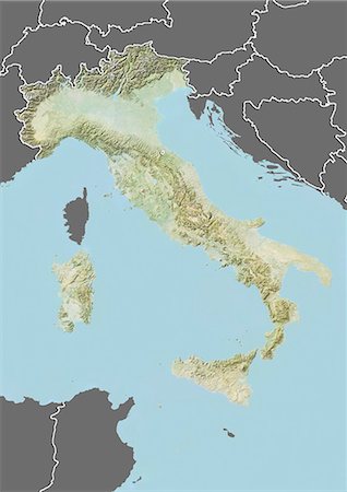
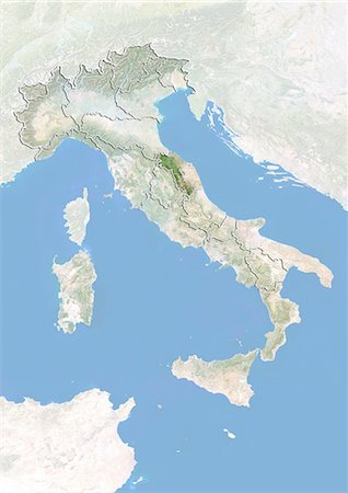
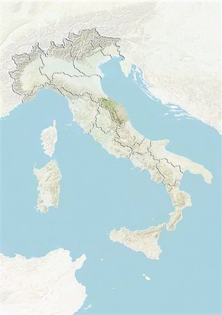
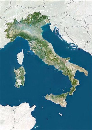
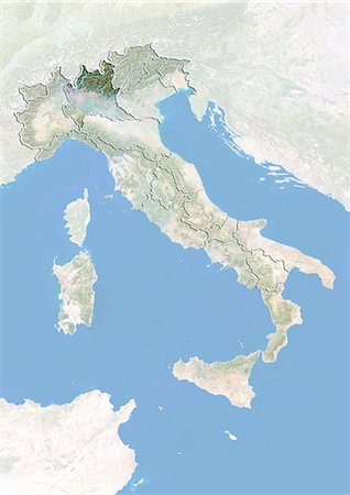
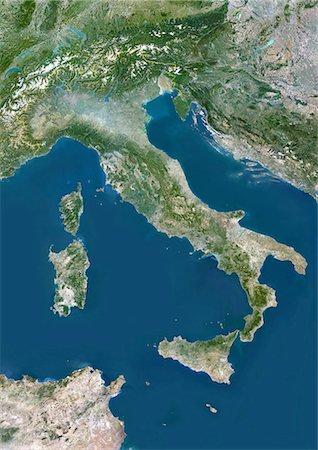
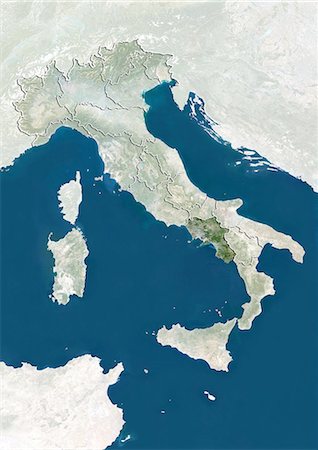
Relief map of Italy (with border and mask). This image was compiled from data acquired by landsat 5 & 7 satellites combined with elevation data.
Rights-Managed
-

-

Satellite view of the region of Umbria, Italy. This image was compiled from data acquired by LANDSAT 5 & 7 satellites.
Rights-Managed
-

Satellite view of the region of Tuscany, Italy. This image was compiled from data acquired by LANDSAT 5 & 7 satellites.
Rights-Managed
-

Satellite view of the region of Trentino-Alto Adige, Italy. This image was compiled from data acquired by LANDSAT 5 & 7 satellites.
Rights-Managed
-

Satellite view of the region of Piedmont, Italy. This image was compiled from data acquired by LANDSAT 5 & 7 satellites.
Rights-Managed
-

Relief map of the region of Piedmont, Italy. This image was compiled from data acquired by LANDSAT 5 & 7 satellites combined with elevation data.
Rights-Managed
-

Relief map of the region of Piedmont, Italy. This image was compiled from data acquired by LANDSAT 5 & 7 satellites combined with elevation data.
Rights-Managed
-

Satellite view of the region of Marche, Italy. This image was compiled from data acquired by LANDSAT 5 & 7 satellites.
Rights-Managed


