-

-

Satellite view of the Caribbean Sea. The entire area of the Caribbean Sea, including all islands of the West Indies is collectively known as the Caribbean. This image was compiled from data acquired by Landsat satellites.
Rights-Managed
-

-
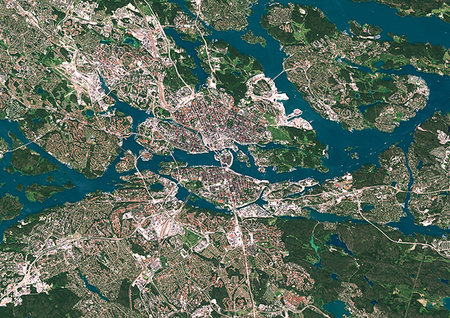
Color satellite image of Stockholm, capital city of Sweden. Image collected on July 06, 2017 by Sentinel-2 satellites.
Rights-Managed
-
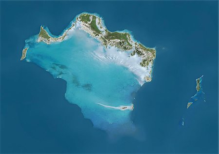
Satellite view of Turks and Caicos Islands. This image was compiled from data acquired by Landsat satellites.
Rights-Managed
-

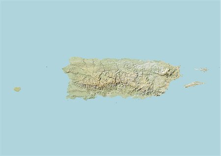
Satellite view of Puerto Rico. This image was compiled from data acquired by Landsat satellites.
Rights-Managed
-
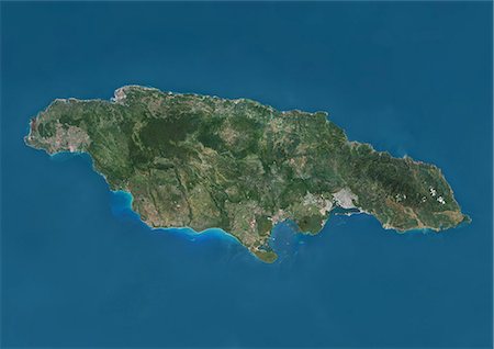
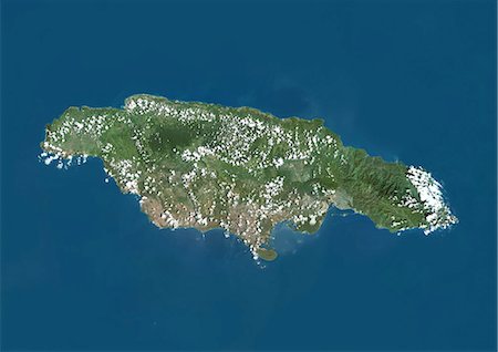
Satellite view of Jamaica. This image was compiled from data acquired by Landsat satellites.
Rights-Managed
-
-
-
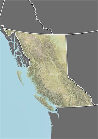
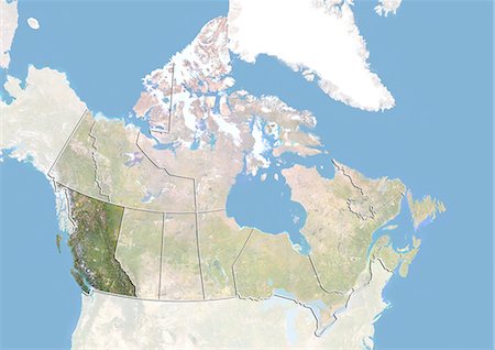
Relief map of British Columbia, Canada. This image was compiled from data acquired by LANDSAT 5 & 7 satellites combined with elevation data.
Rights-Managed
-
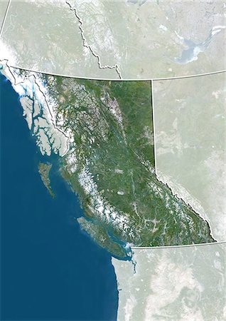
Satellite view of British Columbia, Canada. This image was compiled from data acquired by LANDSAT 5 & 7 satellites.
Rights-Managed
-
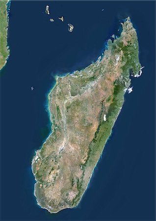
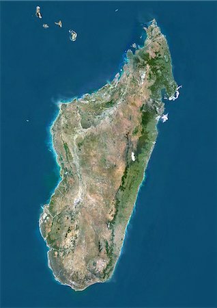
Madagascar, True Colour Satellite Image. Madagascar, true colour satellite image. This image was compiled from data acquired by LANDSAT 5 & 7 satellites.
Rights-Managed
-

Satellite view of Nova Scotia, Canada. This image was compiled from data acquired by LANDSAT 5 & 7 satellites.
Rights-Managed
-

Manicouagan Crater, Quebec, Canada, True Colour Satellite Image. True colour satellite image of Manicouagan Reservoir (also Lake Manicouagan), an annular lake in northern Quebec, Canada, the remnant of an impact crater made approximately 212 million years ago, of 100 km diameter. Image taken on 1 June 2001 using LANDSAT data.
Rights-Managed
-

Caribbean Islands, True Colour Satellite Image. Caribbean Islands, true colour satellite image. This image was compiled from data acquired by LANDSAT 5 & 7 satellites.
Rights-Managed
-
-

Satellite view of Bahrain in 2002 and 2014. This before and after image shows urban expansion over the years.
Rights-Managed
-
Canada and the Province of British Columbia, Satellite Image With Bump Effect
Rights-Managed
-
-
Mount Etna, Sicily, True Colour Satellite Image. Satellite image of Mount Etna, the highest active volcano in Europe, situated North-East of Sicily, 3350m high. Image taken on 23 July 2001 using LANDSAT data.
Rights-Managed
-

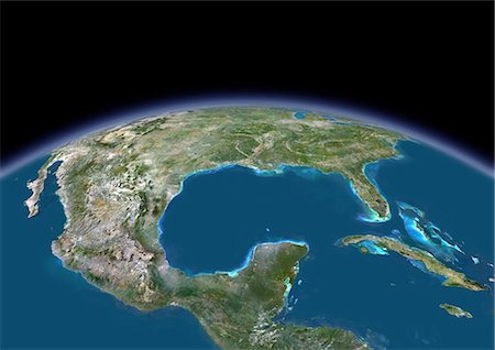
Caribbean Sea, Central America, True Colour Satellite Image. True colour satellite image of the Caribbean Sea. It is bounded to the south and west by Central and South America, with the North Atlantic Ocean to the northeast and the Gulf of Mexico to the northwest. Composite image using LANDSAT 5 data.
Rights-Managed
-

-

Satellite view of the region of Hokkaido, Japan. This image was compiled from data acquired by LANDSAT 5 & 7 satellites.
Rights-Managed
-
Kerguelen Islands, Southern Indian Ocean, True Colour Satellite Image. True colour satellite image of the Kerguelen Islands (France), a group of islands in the southern Indian Ocean that is part of the French Southern and Antarctic Lands.The main island is called Grande Terre. Image using LANDSAT 7 data.
Rights-Managed
-

-
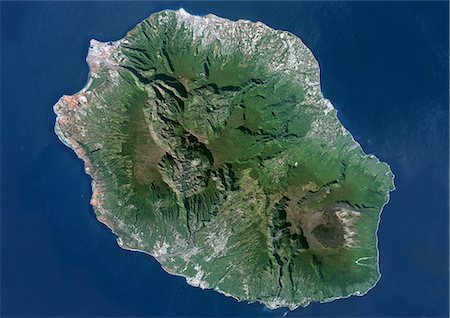
Piton De La Fournaise, Reunion Island, French Overseas, True Colour Satellite Image. Reunion Island, French overseas, true colour satellite image. Reunion island is made of two volcanos, Piton des Neiges volcano, the highest point on the island at 3069m, and Piton de la Fournaise (2632m), an active shield volcano on the Eastern end of Reunion Island. Image taken on 19 June 2000 using LANDSAT data.
Rights-Managed
-

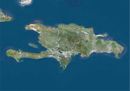
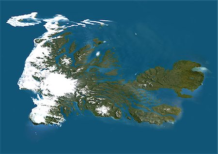
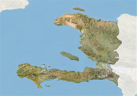
Satellite view of Haiti and The Dominican Republic. This image was compiled from data acquired by Landsat satellites.
Rights-Managed
-

-

Satellite view of England, United Kingdom. This image was compiled from data acquired by LANDSAT 5 & 7 satellites.
Rights-Managed
-
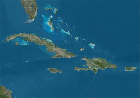
Satellite view of The Greater Antilles and Bahamas. This image was compiled from data acquired by Landsat satellites.
Rights-Managed
-
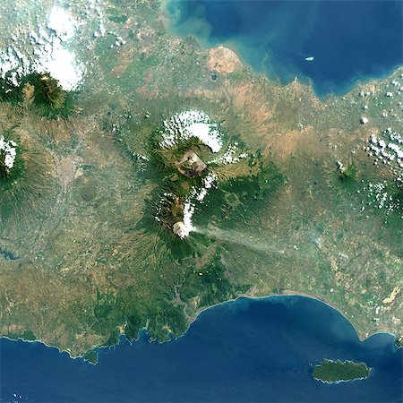
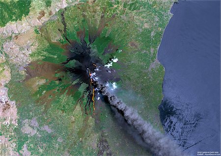
Bromo Volcano, Java Island, Indonesia, True Colour Satellite Image. Java, Indonesia, true colour satellite image. Different volcanoes are located in the 16km-wide Tengger caldera : Bromo (2329m), at the North of this view, and Semeru (3676m), a very active volcano. Image taken on 20 August 1991 using LANDSAT data. Print size 30 x 30 cm.
Rights-Managed
-

Croatia, Europe, True Colour Satellite Image With Border. Satellite view of Croatia (with border). This image was compiled from data acquired by LANDSAT 5 & 7 satellites.
Rights-Managed
-

Satellite view of Scotland including Shetland, United Kingdom. This image was compiled from data acquired by LANDSAT 5 & 7 satellites.
Rights-Managed
-

-
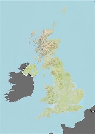
Relief map of the United Kingdom (with border and mask). This image was compiled from data acquired by landsat 5 & 7 satellites combined with elevation data.
Rights-Managed
-
Djerba, Tunisia, True Colour Satellite Image. True colour satellite image of Djerba, an island located in the Gulf of Gabes off the coast of Tunisia. At the bottom of the image is Tunisia mainlain. Image taken on 13 December 1999 using LANDSAT 7 data.
Rights-Managed
-

Piton De La Fournaise Volcano, Reunion Island, French Overseas, True Colour Satellite Image. Piton de la Fournaise, Reunion island, French overseas, true colour satellite image. Piton de la Fournaise (2631m), one of the world's most active volcanoes, is located on the South East part of Reunion Island, in the Indian Ocean. Image taken on 19 June 2000 using LANDSAT data. Print size 30 x 30 cm.
Rights-Managed
-

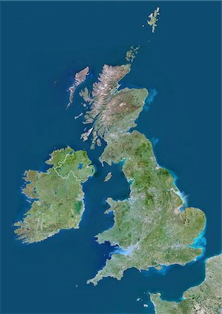
United Kingdom, Europe, True Colour Satellite Image With Mask. Satellite view of the United Kingdom (with mask). This image was compiled from data acquired by LANDSAT 5 & 7 satellites.
Rights-Managed
-

Norway, Europe, True Colour Satellite Image With Border. Satellite view of Norway (with border). This image was compiled from data acquired by LANDSAT 5 & 7 satellites.
Rights-Managed
-

Relief map of British Columbia, Canada. This image was compiled from data acquired by LANDSAT 5 & 7 satellites combined with elevation data.
Rights-Managed
-

-

-

Piton De La Fournaise Volcano In 3D, Reunion Island, French Overseas, True Colour Satellite Image. Piton de la Fournaise, Reunion, true colour satellite image. 3D satellite view of the Piton de la Fournaise (2631m), one of the world's most active volcanoes, located on the South East part of Reunion Island, in the Indian Ocean. Image using LANDSAT data.
Rights-Managed
-

Mediterranean Area, True Colour Satellite Image. Mediterranean Sea. True colour satellite images showing the Mediterranean Sea. Points of interest include the Alps (just above centre, white), the Blakek Sea (centre right), and the Nile Delta (green, lower right). This image was compiled from data acquired by LANDSAT 5 & 7 satellites.
Rights-Managed
-
-

Cozumel Island, Mexico, True Colour Satellite Image. True colour satellite image of Cozumel, an island in the Caribbean Sea off the eastern coast of Mexico's Yucatan Peninsula (left). Image taken on 17 April 2001, using LANDSAT 7 data.
Rights-Managed
-
-
-

Satellite view of the Northwest Territories, Canada. This image was compiled from data acquired by LANDSAT 5 & 7 satellites.
Rights-Managed
-

Balearic Islands, Spain, True Colour Satellite Image. True colour satellite image of the Balearic Islands, a Spanish archipelago in the western Mediterranean Sea. The four largest islands are (from west to east) Ibiza, Formentera, Majorca, Minorca. Image using LANDSAT 7 data.
Rights-Managed
-

Cuba And Cayman Islands, Caribbean, True Colour Satellite Image. Satellite view of Cuba and the Cayman islands. This image was compiled from data acquired by LANDSAT 5 & 7 satellites.
Rights-Managed
-

Relief map of the region of Hokkaido, Japan. This image was compiled from data acquired by LANDSAT 5 & 7 satellites combined with elevation data.
Rights-Managed
-
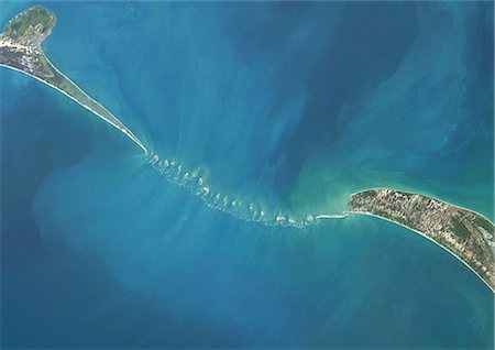
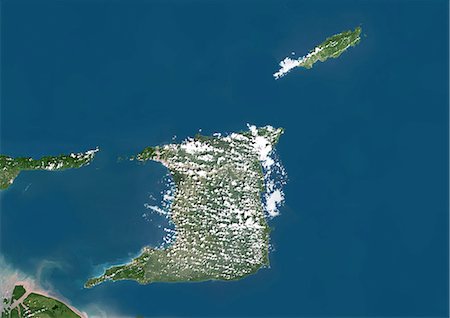
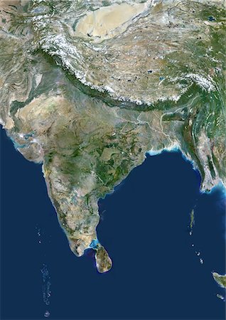
Satellite view of Adam's Bridge. This chain of limestone shoals connects Sri Lanka to India. This image was taken in 2014 by Landsat 8 satellite.
Rights-Managed
-
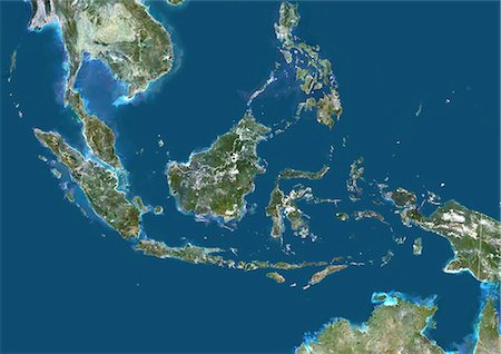
Indonesia, Asia, True Colour Satellite Image With Border. Satellite view of Indonesia (with border). This image was compiled from data acquired by LANDSAT 5 & 7 satellites.
Rights-Managed
-
United Kingdom, Europe, True Colour Satellite Image With Border. Satellite view of Bulgaria (with border). This image was compiled from data acquired by LANDSAT 5 & 7 satellites.
Rights-Managed
-

Galunggung Volcano, Java, Indonesia, True Colour Satellite Image. Galunggung, Java, Indonesia, true colour satellite image. Galunggung volcano (2168m) is located in West Java, Indonesia, near the city of Tasikmalaya. Image taken on 22 June 2001 using LANDSAT data. Print size 30 x 30 cm.
Rights-Managed
-

Maldives, Asia, True Colour Satellite Image. Satellite view of the Maldives. This image was compiled from data acquired by LANDSAT 5 & 7 satellites.
Rights-Managed
-
-

Satellite view of Scotland, United Kingdom. This image was compiled from data acquired by LANDSAT 5 & 7 satellites.
Rights-Managed
-

Greenland, True Colour Satellite Image With Mask. Satellite view of Greenland (with mask). This image was compiled from data acquired by LANDSAT 5 & 7 satellites.
Rights-Managed
-

Mount Pelee, Martinique, France, True Colour Satellite Image. Mount Pelée, true colour satellite image. Mount Pelée is the only active volcano on the Carribean Island of Martinique, it overlooks the town of Saint-Pierre. Image taken on 4 January 2001 using LANDSAT data.
Rights-Managed
-
-
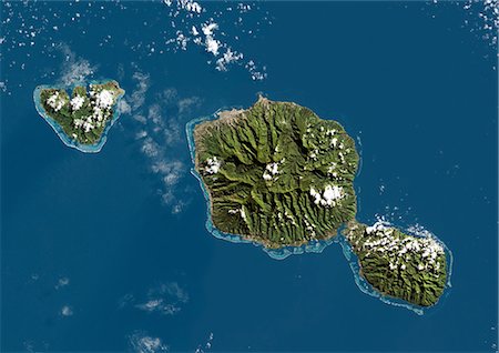
Tahiti, French Polynesia, French Overseas, Oceania, True Colour Satellite Image. Satellite view of Tahiti, French Polynesia, located in the archipelago of Society Islands in the southern Pacific Ocean. This image was compiled from data acquired by LANDSAT 5 & 7 satellites.
Rights-Managed
-

Mauna Loa Volcano, Hawai, Usa, True Colour Satellite Image. Mauna Loa, Hawai, true colour satellite image. Mauna Loa (4170m), one of the tallest mountains in the world, is located on the Big Island of Hawai. Composite image dated 2000-2001 using LANDSAT data. Print size 30 x 30 cm.
Rights-Managed
-
Anguilla, Saint Martin And Saint Barthelemy, True Colour Satellite Image. Anguilla, Saint Martin and Saint Barthelemy, true colour satellite image. Anguilla is at top, Saint Martin is in the center, and St Barts is at bottom right. This image was compiled from data acquired by the LANDSAT 7 satellite.
Rights-Managed
-

Puerto Rico And The Virgin Islands, True Colour Satellite Image. Puerto Rico and the Virgin Islands. True colour satellite image showing Puerto Rico (west) and the Virgin islands (east). Composite image using data from LANDSAT 5 & 7satellites.
Rights-Managed
-
-
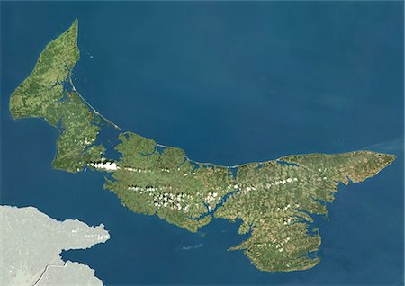
Satellite view of Prince Edward Island, Canada. This image was compiled from data acquired by LANDSAT 5 & 7 satellites.
Rights-Managed
-

Guadeloupe, French Overseas, Caribbean, True Colour Satellite Image. Satellite view of Guadeloupe, France. This image was compiled from data acquired by LANDSAT 5 & 7 satellites.
Rights-Managed
-
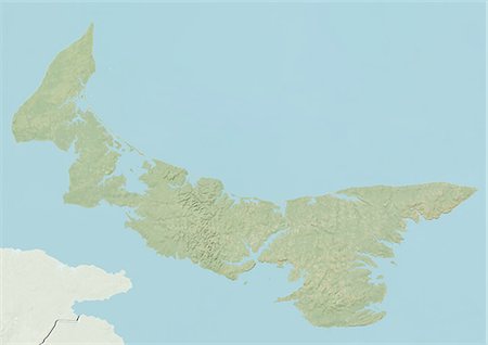
Relief map of Prince Edward Island, Canada. This image was compiled from data acquired by LANDSAT 5 & 7 satellites combined with elevation data.
Rights-Managed
-

Malaysia, Asia, True Colour Satellite Image With Mask. Satellite view of Malaysia (with mask). This image was compiled from data acquired by LANDSAT 5 & 7 satellites.
Rights-Managed
-
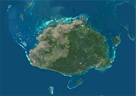
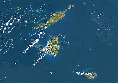
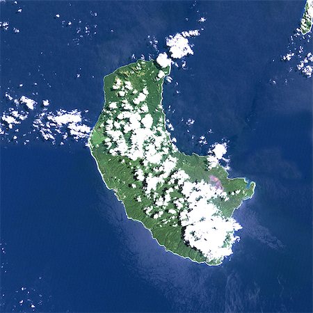
Satellite view of Viti Levu Island, Fiji. This is the largest island in the Republic of Fiji and the site of the nation's capital, Suva. This image was compiled from data acquired by Landsat 8 satellite in 2014.
Rights-Managed
-

Color satellite image of Southern Florida, United States. It shows Miami at east, Everglades National Park at center, and the Florida Keys at south. Image collected on January 06, 2017 by Sentinel-2 satellites.
Rights-Managed
-
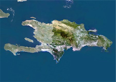
Haiti (With Mask And Border) And Dominican Republic, True Colour Satellite Image. Haiti (with mask and border) and Dominican Republic, true colour satellite image. This image was compiled from data acquired by LANDSAT 5 & 7 satellites.
Rights-Managed
-

New Zealand, True Colour Satellite Image. New Zealand, true colour satellite image. This image was compiled from data acquired by LANDSAT 5 & 7 satellites.
Rights-Managed
-
-

-
-

Satellite view of Newfoundland and Labrador, Canada. This image was compiled from data acquired by LANDSAT 5 & 7 satellites.
Rights-Managed
-

-

Satellite view of Taiwan. This image was compiled from data acquired by Landsat satellites.
Rights-Managed
-

-
-

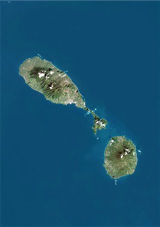
Cape Verde, Africa, True Colour Satellite Image. Satellite view of the Cape Verde archipelago. This image was compiled from data acquired by LANDSAT 5 & 7 satellites.
Rights-Managed
-

Satellite view of Andros Islands and New Providence, Bahamas. New Providence is the most populous island in the Bahamas and it houses the capital city of Nassau. This image was compiled from data acquired by Landsat satellites.
Rights-Managed
-

-

Channel Islands, Europe, True Colour Satellite Image. True colour satellite image of the Channel Islands, an archipelago in the English Channel, off the French coast of Normandy. the main islands are Jersey, Guernsey, Alderney, Sark and Herm. Image using LANDSAT 7 data.
Rights-Managed
-

-

Satellite view of Cyclone Noul in 2015 approaching the Philippines. Image taken on May 8, 2015.
Rights-Managed
-
Yasur Volcano, Vanuatu, Pacific, True Colour Satellite Image. Yasur volcano, Vanuatu, true colour satellite image. Yasur (365m) is a small active volcano on Tanna island, in Vanuatu. Composite image dated 1999-2000 using LANDSAT data. Print size 30 x 30 cm.
Rights-Managed


