-

Glass sphere representing Europe, Russia, Middle East, China and India
Premium Royalty-Free
-

-

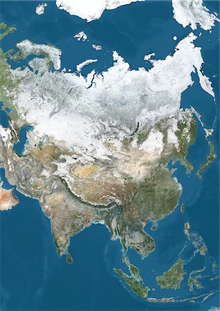
Satellite view of Asia. This image was compiled from data acquired by Landsat 7 & 8 satellites.
Rights-Managed
-
-
Satellite view of Asia in winter, with partial snow cover. This image was compiled from data acquired by Landsat 7 & 8 satellites.
Rights-Managed
-

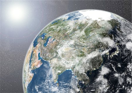
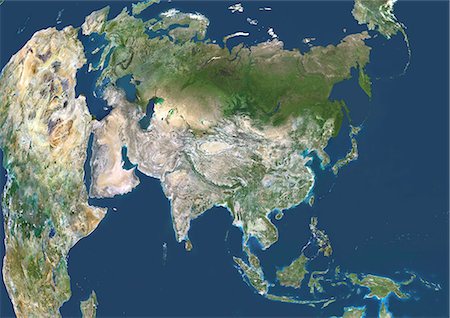
Globe Showing Asia, True Colour Satellite Image. True colour satellite image of the Earth showing Asia and the North Pole. This image in orthographic projection was compiled from data acquired by LANDSAT 5 & 7 satellites.
Rights-Managed
-

-

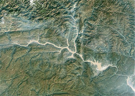
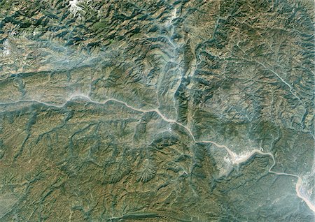
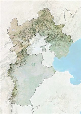
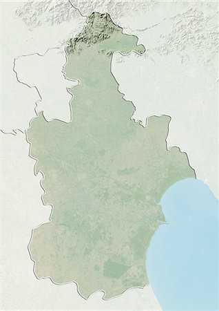
Relief map of the province of Yunnan, China. This image was compiled from data acquired by LANDSAT 5 & 7 satellites combined with elevation data.
Rights-Managed
-

-

Glass globe representing Europe, Russia, Middle East, China and India
Premium Royalty-Free
-

-
-
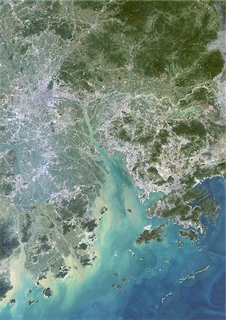
Canton And Shenzen, China, In 2000, True Colour Satellite Image. True colour satellite image of the cities of Guangzhou (Canton) and Shenzen, China. Image in portrait format, taken on 14 September 2000, using LANDSAT data.
Rights-Managed
-
-

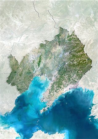
Relief map of the province of Guangdong, China. This image was compiled from data acquired by LANDSAT 5 & 7 satellites combined with elevation data.
Rights-Managed
-
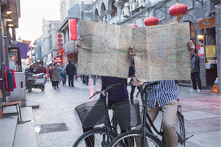
Tourist with a map at Yu Yuan Garden, Huangpu District, Shanghai, China, Asia
Rights-Managed
-
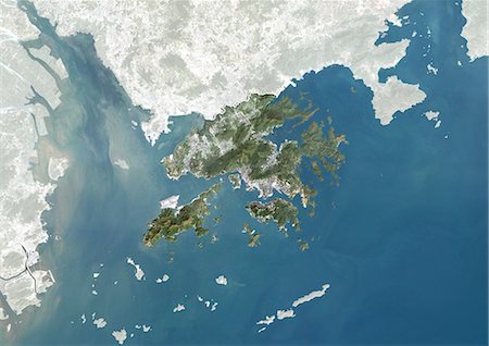
Satellite view of Hong Kong, China. This image was compiled from data acquired by LANDSAT 7 satellite.
Rights-Managed
-

-

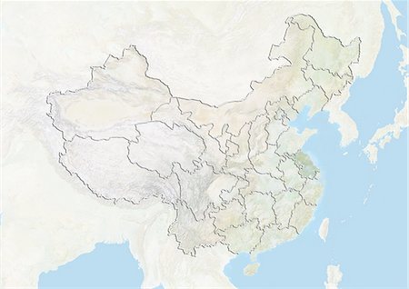
Relief map of China (with border and mask). This image was compiled from data acquired by landsat 5 & 7 satellites combined with elevation data.
Rights-Managed
-
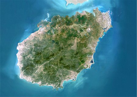
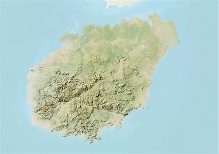
Satellite view of the province of Hainan, China. This image was compiled from data acquired by LANDSAT 5 & 7 satellites.
Rights-Managed
-

Globe Showing Asia, True Colour Satellite Image. True colour satellite image of the Earth showing Asia, half in shadow, and the sun. This image in orthographic projection was compiled from data acquired by LANDSAT 5 & 7 satellites.
Rights-Managed
-
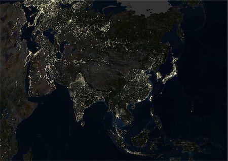
Asia At Night, True Colour Satellite Image. True colour satellite image of Asia at night. This image in Lambert Azimuthal Equal Area projection was compiled from data acquired by LANDSAT 5 & 7 satellites.
Rights-Managed
-

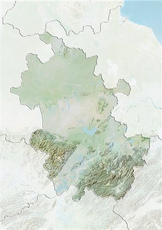
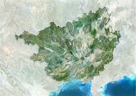
Relief map of the region of Guangxi, China. This image was compiled from data acquired by LANDSAT 5 & 7 satellites combined with elevation data.
Rights-Managed
-
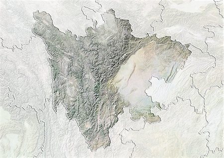
Relief map of the province of Sichuan, China. This image was compiled from data acquired by LANDSAT 5 & 7 satellites combined with elevation data.
Rights-Managed
-
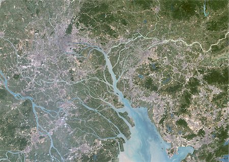
Canton And Shenzen, China, In 2000, True Colour Satellite Image. True colour satellite image of the cities of Guangzhou (Canton) and Shenzen, China. Image in landscape format, taken on 14 September 2000, using LANDSAT data.
Rights-Managed
-
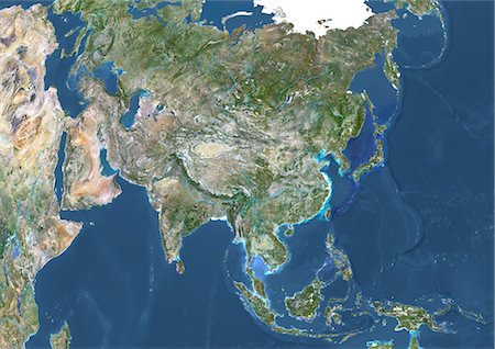
Asia With Major Rivers, True Colour Satellite Image. True colour satellite image of Asia with major rivers. This image in Lambert Azimuthal Equal Area projection was compiled from data acquired by LANDSAT 5 & 7 satellites.
Rights-Managed
-
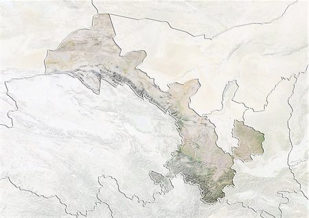
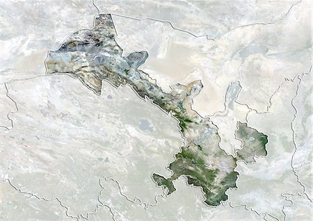
Relief map of Xinjiang, China. This image was compiled from data acquired by LANDSAT 5 & 7 satellites combined with elevation data.
Rights-Managed
-
Relief map of the province of Anhui, China. This image was compiled from data acquired by LANDSAT 5 & 7 satellites combined with elevation data.
Rights-Managed
-
Globe Showing Asia, True Colour Satellite Image. True colour satellite image of the Earth showing Asia, half in shadow, with cloud coverage, and the sun. This image in orthographic projection was compiled from data acquired by LANDSAT 5 & 7 satellites.
Rights-Managed
-
Relief map of the province of Gansu, China. This image was compiled from data acquired by LANDSAT 5 & 7 satellites combined with elevation data.
Rights-Managed
-

Asia With Country Borders And Major Rivers, True Colour Satellite Image. True colour satellite image of Asia with country borders and major rivers. This image in Lambert Azimuthal Equal Area projection was compiled from data acquired by LANDSAT 5 & 7 satellites.
Rights-Managed
-
Three Gorges Region, China, In 2000, True Colour Satellite Image. True colour satellite image of the Three Gorges region along the Yangtze River, China. Image taken in 2000, using LANDSAT data.
Rights-Managed
-

Satellite view of Ningxia Hui, China. This image was compiled from data acquired by LANDSAT 5 & 7 satellites.
Rights-Managed
-

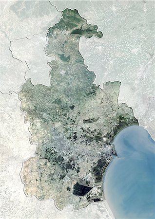
Shanghai, China, True Colour Satellite Image. Shanghai, People's Republic of China. True colour satellite image of the city of Shanghai, taken on 3 July 2001, using LANDSAT 7 data.
Rights-Managed
-

Yellow Sea, Asia, True Colour Satellite Image. True colour satellite image of the Yellow Sea, the northern part of the East China Sea. It is located between mainland China and the Korean peninsula. Composite image using LANDSAT 5 data.
Rights-Managed
-

Satellite view of the province of Guangdong, China. This image was compiled from data acquired by LANDSAT 5 & 7 satellites.
Rights-Managed
-

Southeast Asia, True Colour Satellite Image. Southeast Asia true colour satellite image. This image was compiled from data acquired by LANDSAT 5 & 7 satellites.
Rights-Managed
-

Takla-Makan Desert, Xinjiang, China, True Colour Satellite Image. True colour satellite image of the Takla-Makan desert in the Xinjiang province, with the river Yurungkax. Image taken on 5 October 1990 using LANDSAT data.
Rights-Managed
-
-

Asia With Cloud Coverage, True Colour Satellite Image. True colour satellite image of Asia with cloud coverage. This image in Lambert Azimuthal Equal Area projection was compiled from data acquired by LANDSAT 5 & 7 satellites.
Rights-Managed
-

Satellite view of the province of Shandong, China. This image was compiled from data acquired by LANDSAT 5 & 7 satellites.
Rights-Managed
-
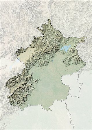
Relief map of the region of Beijing, China. This image was compiled from data acquired by LANDSAT 7 satellite combined with elevation data.
Rights-Managed
-
-

Relief map of the province of Shanxi, China. This image was compiled from data acquired by LANDSAT 5 & 7 satellites combined with elevation data.
Rights-Managed
-
Three Gorges Region, China, In 1987, True Colour Satellite Image. True colour satellite image of the Three Gorges region along the Yangtze River, China. Image taken in 1987, using LANDSAT data.
Rights-Managed
-
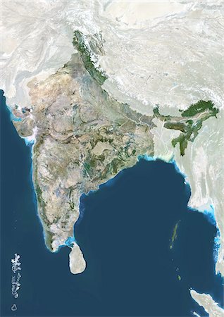
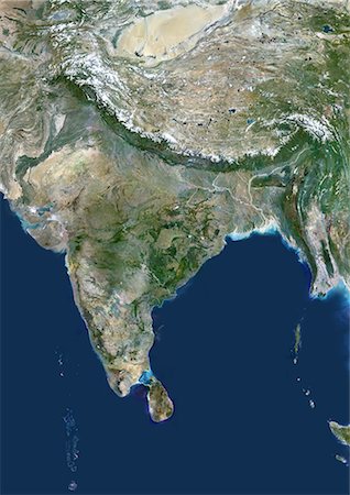
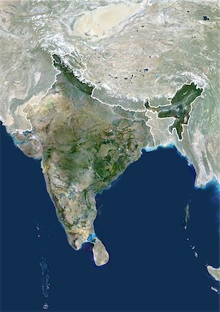
India, True Colour Satellite Image With Mask. India, true colour satellite image with mask This image was compiled from data acquired by LANDSAT 5 & 7 satellites.
Rights-Managed
-

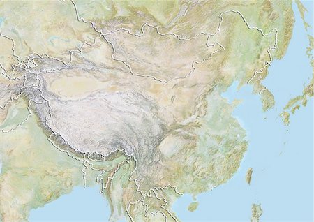
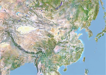
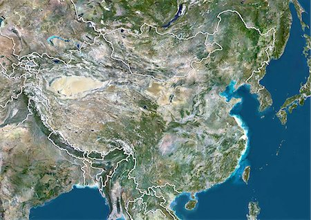
China, True Colour Satellite Image. People's Republic of China, true colour satellite image. This image was compiled from data acquired by LANDSAT 5 & 7 satellites.
Rights-Managed
-

China, True Colour Satellite Image With Mask And Border. People's Republic of China, true colour satellite image with mask and border. This image was compiled from data acquired by LANDSAT 5 & 7 satellites.
Rights-Managed
-
-

Businesswoman using phone and looking at computer while eating take out food
Premium Royalty-Free
-

-

-

-

Relief map of the province of Hubei, China. This image was compiled from data acquired by LANDSAT 5 & 7 satellites combined with elevation data.
Rights-Managed
-
Relief map of the province of Hebei, China. This image was compiled from data acquired by LANDSAT 5 & 7 satellites combined with elevation data.
Rights-Managed
-
Relief map of the province of Hainan, China. This image was compiled from data acquired by LANDSAT 5 & 7 satellites combined with elevation data.
Rights-Managed
-
Satellite view of the province of Gansu, China. This image was compiled from data acquired by LANDSAT 5 & 7 satellites.
Rights-Managed
-
Satellite view of the province of Zhejiang, China. This image was compiled from data acquired by LANDSAT 5 & 7 satellites.
Rights-Managed
-

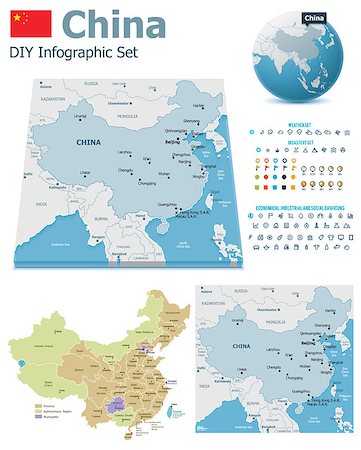
Vector map of China with named divisions and travel icons
Budget Royalty-Free & Subscription
-

Satellite view of the province of Shanxi, China. This image was compiled from data acquired by LANDSAT 5 & 7 satellites.
Rights-Managed
-

-

Asia At Night With Cloud Coverage, True Colour Satellite Image. True colour satellite image of Asia at night with cloud coverage. This image in Lambert Azimuthal Equal Area projection was compiled from data acquired by LANDSAT 5 & 7 satellites.
Rights-Managed
-

-
Satellite view of Tianjin, China. This image was compiled from data acquired by LANDSAT 7 satellite.
Rights-Managed
-
Relief map of Tianjin, China. This image was compiled from data acquired by LANDSAT 7 satellite combined with elevation data.
Rights-Managed
-

-

-

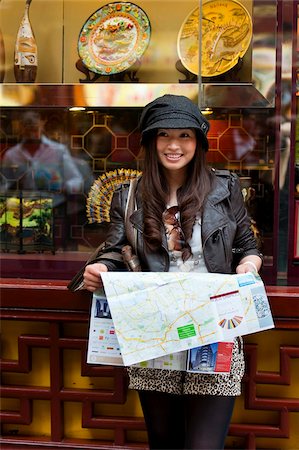
Grandparents and granddaughter standing next to the car and looking at the map
Premium Royalty-Free
-

-

-
Satellite view of the province of Liaoning, China. This image was compiled from data acquired by LANDSAT 5 & 7 satellites.
Rights-Managed
-
-

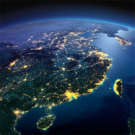
Highly detailed Earth, illuminated by moonlight. The glow of cities sheds light on the detailed exaggerated terrain. Night Earth. Eastern China and Taiwan. Elements of this image furnished by NASA
Budget Royalty-Free & Subscription
-

-

-
Satellite view of the region of Guangxi, China. This image was compiled from data acquired by LANDSAT 5 & 7 satellites.
Rights-Managed
-

Satellite view of the province of Jiangsu, China. This image was compiled from data acquired by LANDSAT 5 & 7 satellites.
Rights-Managed
-
Night planet Earth with precise detailed relief and city lights illuminated by moonlight. Eastern China and Taiwan. Elements of this image furnished by NASA
Budget Royalty-Free & Subscription
-
-
Relief map of the province of Zhejiang, China. This image was compiled from data acquired by LANDSAT 5 & 7 satellites combined with elevation data.
Rights-Managed
-
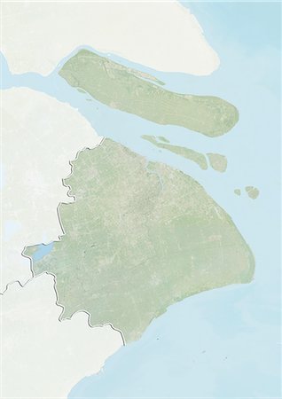
Relief map of Shanghai, China. This image was compiled from data acquired by LANDSAT 7 satellite combined with elevation data.
Rights-Managed
-

-

Canton, China, In 2000, True Colour Satellite Image. True colour satellite image of the city of Guangzhou (Canton), China. Image taken on 14 September 2000, using LANDSAT data.
Rights-Managed
-
-
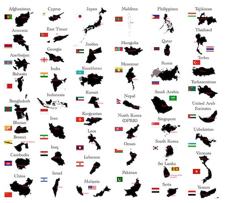
Set of the political China maps, markers and symbols for infographic
Budget Royalty-Free & Subscription
-

Sun over Southeast Asia on blue planet Earth isolated on black background. Highly detailed planet surface. Elements of this image furnished by NASA.
Budget Royalty-Free & Subscription
-

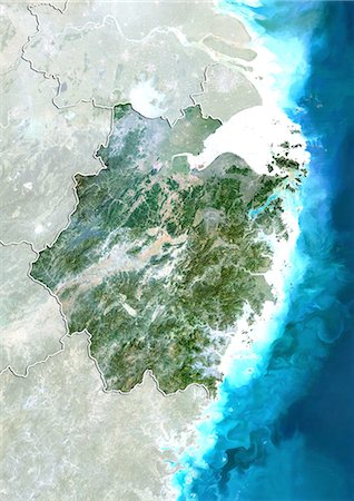
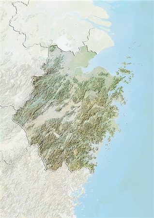
Relief map of the province of Fujian, China. This image was compiled from data acquired by LANDSAT 5 & 7 satellites combined with elevation data.
Rights-Managed
-

Satellite view of the province of Yunnan, China. This image was compiled from data acquired by LANDSAT 5 & 7 satellites.
Rights-Managed
-

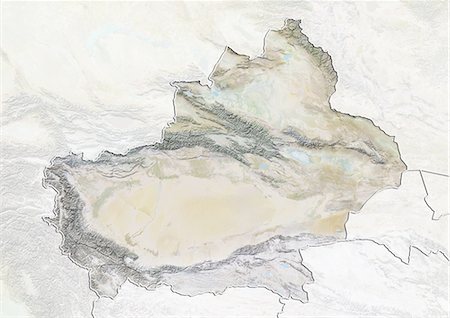
Satellite view of Xinjiang, China. This image was compiled from data acquired by LANDSAT 5 & 7 satellites.
Rights-Managed
-

Satellite view of Tibet, China. This image was compiled from data acquired by LANDSAT 5 & 7 satellites.
Rights-Managed


