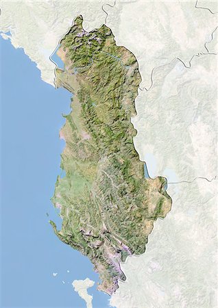
-

Satellite view of the Caribbean Sea. The entire area of the Caribbean Sea, including all islands of the West Indies is collectively known as the Caribbean. This image was compiled from data acquired by Landsat satellites.
Rights-Managed
-
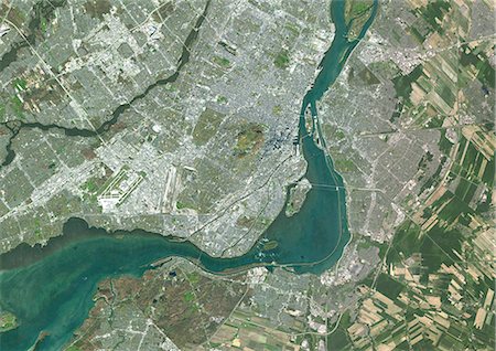
Colour satellite image of Montreal, Quebec, Canada. Image taken on November 11, 2014 with Landsat 8 data.
Rights-Managed
-

Relief map of the State of California, United States. This image was compiled from data acquired by LANDSAT 5 & 7 satellites combined with elevation data.
Rights-Managed
-

-

-

-

-

Satellite view of Puerto Rico. This image was compiled from data acquired by Landsat satellites.
Rights-Managed
-

-
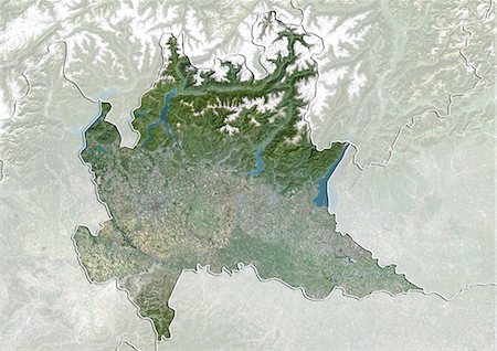
Satellite view of the region of Lombardy, Italy. This image was compiled from data acquired by LANDSAT 5 & 7 satellites.
Rights-Managed
-
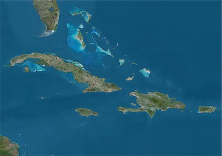
Satellite view of The Greater Antilles and Bahamas. This image was compiled from data acquired by Landsat satellites.
Rights-Managed
-

-

-
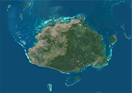
Satellite view of Viti Levu Island, Fiji. This is the largest island in the Republic of Fiji and the site of the nation's capital, Suva. This image was compiled from data acquired by Landsat 8 satellite in 2014.
Rights-Managed
-
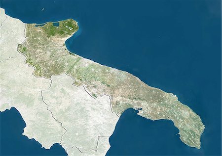
Satellite view of the region of Apulia, Italy. This image was compiled from data acquired by LANDSAT 5 & 7 satellites.
Rights-Managed
-
-

-

-

-
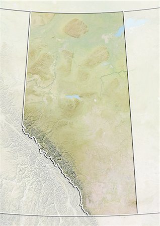
Relief map of Alberta, Canada. This image was compiled from data acquired by LANDSAT 5 & 7 satellites combined with elevation data.
Rights-Managed
-

-

Satellite view of Bahrain in 2002 and 2014. This before and after image shows urban expansion over the years.
Rights-Managed
-
Satellite view of the State of Hamburg, Germany. This image was compiled from data acquired by LANDSAT 5 & 7 satellites.
Rights-Managed
-
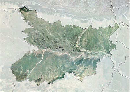
Satellite view of the State of Bihar, India. This image was compiled from data acquired by LANDSAT 5 & 7 satellites.
Rights-Managed
-
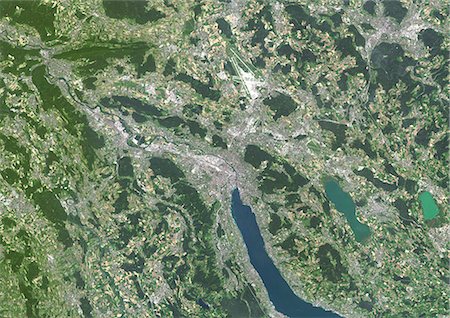
Colour satellite image of Zurich, Switzerland. Image taken on July 19, 2014 with Landsat 8 data.
Rights-Managed
-

Satellite view of Abu Dhabi, United Arab Emirates in 1985 and 2014. This before and after image shows urban expansion over the years.
Rights-Managed
-
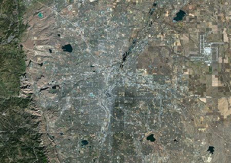
Color satellite image of Denver, Colorado, United States. Image collected on January 4, 2018 by Sentinel-2 satellites.
Rights-Managed
-

Color satellite image of Barcelona, Spain. Image collected on July 12, 2017 by Sentinel-2 satellites.
Rights-Managed
-
-

Satellite view of Nova Scotia, Canada. This image was compiled from data acquired by LANDSAT 5 & 7 satellites.
Rights-Managed
-
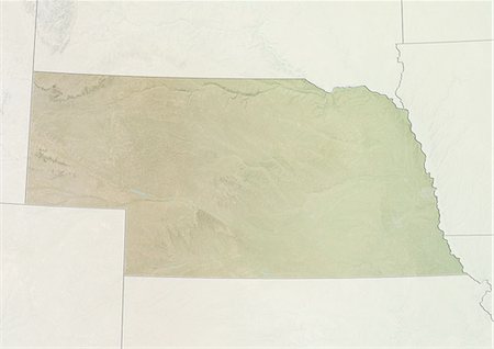
Relief map of the State of Nebraska, United States. This image was compiled from data acquired by LANDSAT 5 & 7 satellites combined with elevation data.
Rights-Managed
-

-
-

-

-
-

-
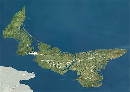
Satellite view of Prince Edward Island, Canada. This image was compiled from data acquired by LANDSAT 5 & 7 satellites.
Rights-Managed
-
-

Colour satellite image of Oran, Algeria. Image taken on September 1, 2014 with Landsat 8 data.
Rights-Managed
-

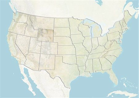
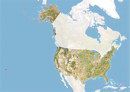
United States and the State of Kentucky, Satellite Image With Bump Effect
Rights-Managed
-
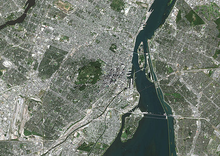
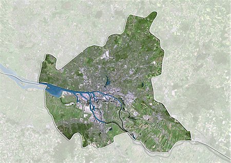
Color satellite image of Montreal, Quebec, Canada. The Saint Lawrence River flows through the city. Image collected on October 03, 2017 by Sentinel-2 satellites.
Rights-Managed
-
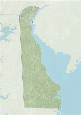
Relief map of the State of Delaware, United States. This image was compiled from data acquired by LANDSAT 5 & 7 satellites combined with elevation data.
Rights-Managed
-

-

-
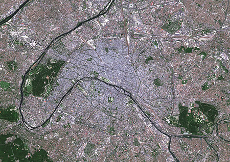
Color satellite image of Paris, capital city of France. The Seine River flows through the city. Image collected on May 26, 2017 by Sentinel-2 satellites.
Rights-Managed
-

-

-
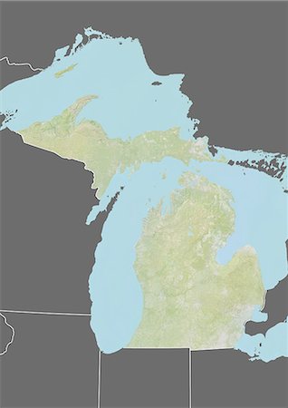
Relief map of the State of Michigan, United States. This image was compiled from data acquired by LANDSAT 5 & 7 satellites combined with elevation data.
Rights-Managed
-
-

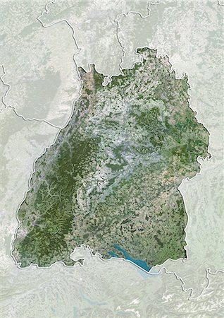
Relief map of the State of Baden-Wurttemberg, Germany. This image was compiled from data acquired by LANDSAT 5 & 7 satellites combined with elevation data.
Rights-Managed
-

-

-

Color satellite image of Occidental Glacier, Patagonia, Chile on May 24, 2016.
Rights-Managed
-

-
-

Satellite view of Quebec, Canada. This image was compiled from data acquired by LANDSAT 5 & 7 satellites.
Rights-Managed
-

-

-

-
-

-

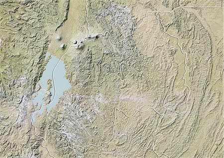
Relief map of the State of California, United States. This image was compiled from data acquired by LANDSAT 5 & 7 satellites combined with elevation data.
Rights-Managed
-
-

-

Relief map of Lower Normandy, France. This image was compiled from data acquired by LANDSAT 5 & 7 satellites combined with elevation data.
Rights-Managed
-

Relief map of the State of Indiana, United States. This image was compiled from data acquired by LANDSAT 5 & 7 satellites combined with elevation data.
Rights-Managed
-
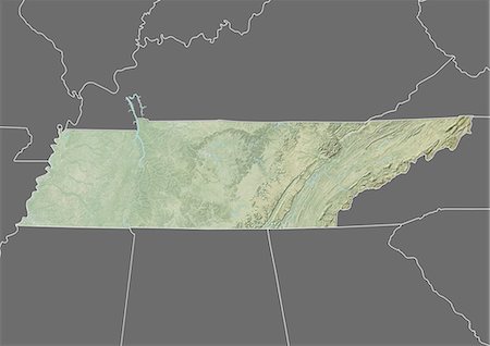
Relief map of the State of Tennessee, United States. This image was compiled from data acquired by LANDSAT 5 & 7 satellites combined with elevation data.
Rights-Managed
-

Satellite view of Alsace, France. This image was compiled from data acquired by LANDSAT 5 & 7 satellites.
Rights-Managed
-
Switzerland and the Canton of Appenzell Innerrhoden, True Colour Satellite Image
Rights-Managed
-
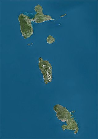
Satellite view of Guadeloupe, Dominica and Martinique. This image was compiled from data acquired by Landsat satellites.
Rights-Managed
-
Satellite view of the State of Baden-Wurttemberg, Germany. This image was compiled from data acquired by LANDSAT 5 & 7 satellites.
Rights-Managed
-

Satellite view of the province of Guangdong, China. This image was compiled from data acquired by LANDSAT 5 & 7 satellites.
Rights-Managed
-

Color satellite image of Dublin, capital city of Ireland. Image collected on June 17, 2017 by Sentinel-2 satellites.
Rights-Managed
-
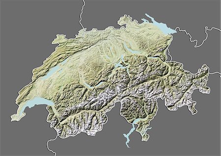
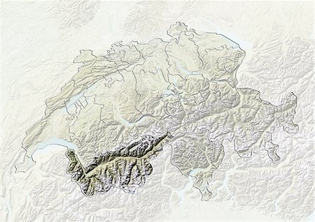
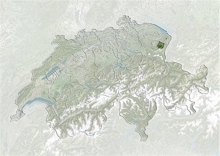
Relief map of Switzerland (with border and mask). This image was compiled from data acquired by landsat 5 & 7 satellites combined with elevation data.
Rights-Managed
-

Relief map of the State of Nevada, United States. This image was compiled from data acquired by LANDSAT 5 & 7 satellites combined with elevation data.
Rights-Managed
-

-

-
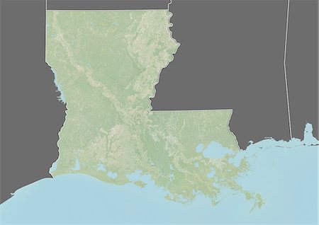
Relief map of the State of Louisiana, United States. This image was taken in 2003 before Hurricane Katrina. It was compiled from data acquired by LANDSAT 7 satellite combined with elevation data.
Rights-Managed
-
-

-

Satellite view of Northern Ireland, United Kingdom. This image was compiled from data acquired by LANDSAT 5 & 7 satellites.
Rights-Managed
-

-

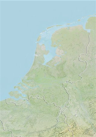
Colour satellite image of Amsterdam, Netherlands. Image taken on September 17, 2014 with Landsat 8 data.
Rights-Managed
-

-
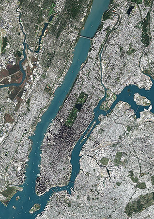
Color satellite image of Manhattan, New York City, New York State, United States. Manhattan is one borough of New York City. It is bound by Hudson River to the west, Harlem River to the north, and East River to the east. Central Park is in the center. Image collected on October 20, 2017 by Sentinel-2 satellites.
Rights-Managed
-
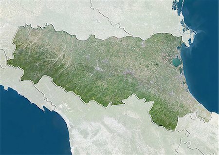
Satellite view of the region of Emilia Romagna, Italy. This image was compiled from data acquired by LANDSAT 5 & 7 satellites.
Rights-Managed
-

-
-

Satellite view of the State of Florida, United States. This image was compiled from data acquired by LANDSAT 5 & 7 satellites.
Rights-Managed


