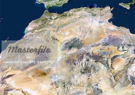
Maghreb Countries, True Colour Satellite Image. True colour satellite image of the Maghreb, region of Africa, north of the Sahara Desert and west of the Nile - specifically, coinciding with the Atlas Mountains. This area includes Morocco, Western Sahara, Algeria, Tunisia, Libya, and Mauritania. This image was compiled from data acquired by LANDSAT 5 & 7 satellites.

872-06052752
Artista: Universal Images Group
Oferta introductoria
Obtener 50% de descuento cuando se une a nuestra lista de correo electrónico
-
Resolución de Internet
550×388px
19.4×13.7cm 28ppcm
-
Baja resolución
1007×712px
35.6×25.2cm 28ppcm
-
Mediana resolución
2229×1576px
18.9×13.3cm 118ppcm
-
Alta resolución
4961×3508px
42.0×29.7cm 118ppcm
* Precio final basado en el uso, no en el tamaño del archivo.
Palabras clave relacionadas
- 872-
- África
- África del Norte
- africano (lugares y cosas)
- africano (perteneciente a Africa)
- Algeria
- desierto (terreno árido)
- escena costera
- escenas de costa
- fotógrafia
- fotografía (arte)
- fotógrafias
- imagen a color
- litoral
- mapa
- Marruecos
- montaña
- montañas
- océano
- región costanera
- sacar fotos
- Túnez (país)
- turismo
- Universal Images Group
- vista de satélite
Imágenes relacionadas
- Mediterranean Area, True Colour Satellite Image. Mediterranean Sea. True colour satellite images showing the Mediterranean Sea. Points of interest include the Alps (just above centre, white), the Blakek Sea (centre right), and the Nile Delta (green, lower right). This image was compiled from data acquired by LANDSAT 5 & 7 satellites.
- Tunisia, True Colour Satellite Image With Mask And Border. Tunisia, true colour satellite image with mask and border. North is at top. Around forty-five percent of the country is composed of the Sahara desert, with much of the remainder consisting of particularly fertile soil, with easily accessible coasts. This image was compiled from data acquired by LANDSAT 5 & 7 satellites.
- Tunisia, True Colour Satellite Image With Border. Tunisia, true colour satellite image with border. North is at top. Around forty-five percent of the country is composed of the Sahara desert, with much of the remainder consisting of particularly fertile soil, with easily accessible coasts. This image was compiled from data acquired by LANDSAT 5 & 7 satellites.
- Morocco, True Colour Satellite Image With Mask And Border. Morocco. True colour satellite image of Morocco, with mask and border. The Strait of Gibraltar is at top center. The Mediterranean Sea is to the east of this strait, with the Atlantic Ocean to the west. This image was compiled from data acquired by LANDSAT 5 & 7 satellites.
- Morocco, True Colour Satellite Image With Border. Morocco. True colour satellite image of Morocco, with border. The Strait of Gibraltar is at top center. The Mediterranean Sea is to the east of this strait, with the Atlantic Ocean to the west. This image was compiled from data acquired by LANDSAT 5 & 7 satellites.
- Satellite View of Algeria
- Tunisia, True Colour Satellite Image With Mask. Tunisia, true colour satellite image with mask. North is at top. Around forty-five percent of the country is composed of the Sahara desert, with much of the remainder consisting of particularly fertile soil, with easily accessible coasts. This image was compiled from data acquired by LANDSAT 5 & 7 satellites.
- Satellite View of Algeria and Surrounding Area
Más imágenes relacionadas
- Satellite View of Morocco and Surrounding Area
- Mauritania, Africa, True Colour Satellite Image With Mask. Satellite view of Mauritania (with border and mask). This image was compiled from data acquired by LANDSAT 5 & 7 satellites.
- Libya, Africa, True Colour Satellite Image With Mask. Satellite view of Libya (with mask). This image was compiled from data acquired by LANDSAT 5 & 7 satellites.
- Libya, Africa, True Colour Satellite Image With Border And Mask. Satellite view of Libya (with border and mask). This image was compiled from data acquired by LANDSAT 5 & 7 satellites.
- Libya, Africa, True Colour Satellite Image With Border. Satellite view of Libya (with border). This image was compiled from data acquired by LANDSAT 5 & 7 satellites.
- Mauritania, Africa, True Colour Satellite Image With Border And Mask. Satellite view of Mauritania (with border and mask). This image was compiled from data acquired by LANDSAT 5 & 7 satellites.
- Mauritania, Africa, True Colour Satellite Image With Border. Satellite view of Mauritania (with border). This image was compiled from data acquired by LANDSAT 5 & 7 satellites.
- Sahara Desert, Africa, True Colour Satellite Image. Sahara desert, true colour satellite image. The Sahara is the world's largest hot desert, made of sand and volcanic mountains. Composite image using data from LANDSAT 5 & 7 satellites.


