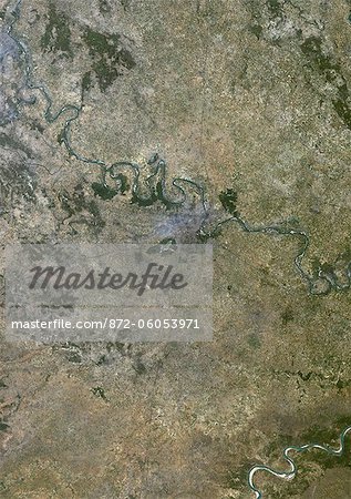
Agra, India, True Colour Satellite Image. True colour satellite image of the city of Agra and surroundings in India. It is a city located on the banks of the Yamuna River in the northern state of Uttar Pradesh, India. The city is famous for its UNESCO World Heritage Sites : the Taj Mahal, the Agra Fort and Fatehpur Sikri. Image taken on 22 October 1999, using LANDSAT 7 data.

Introductory Offer
Save 50% when you join our email list
-
Web Resolution
388×550px
5.4×7.6in 72ppi
-
Low Resolution
712×1007px
9.9×14.0in 72ppi
-
Medium Resolution
1576×2229px
5.3×7.4in 300ppi
-
High Resolution
3508×4961px
11.7×16.5in 300ppi
* Final price based on usage, not file size.
Related Keywords
- 872-
- Agra
- Agra Fort
- Asia
- Asian (places and things)
- city
- color image
- color photography
- color picture
- environment
- Fatehpur Sikri
- Fatehpur-Sikri
- image
- India
- map
- ocean
- photograph
- photography
- picture
- satellite view
- stock photograph
- stock picture
- Taj Mahal
- tourism
- UNESCO World Heritage Site
- Universal Images Group
- Uttar Pradesh
- water
Related Images
- Indus Delta, Pakistan, True Colour Satellite Image. True colour satellite image of the Indus Delta in Pakistan. The Indus River flows into the Arabian Sea near Pakistan's port city of Karachi (top left on the image). The city of Hyderabad, located on the east bank of the Indus River, is on the top centre of the image. India is southeast of the Indus delta. Composite image using LANDSAT 7 data.
- Satellite View of India and Surrounding Area
- Phuket, Thailand, True Colour Satellite Image. True colour satellite image of Phuket, Thailand. It is the biggest island in Thailand, located in the Andaman Sea in southern Thailand. Composite image using LANDSAT 7 data.
- Mahanadi River Delta, India, True Colour Satellite Image. True colour satellite image of the Mahanadi River Delta in India. The Mahanadi River flows into the Gulf of Bengal. Composite image using LANDSAT 7 data.
- Krishna River Delta, India, True Colour Satellite Image. True colour satellite image of Krishna River Delta in India. The Krishna River flows into the Bay of Bengal. Composite image using LANDSAT 7 data.
- Kaveri River Delta, India, True Colour Satellite Image. True colour satellite image of the Kaveri River Delta in India. The Kaveri River empties into the Gulf of Bengal. Composite image using LANDSAT 7 data.
- Godavari River Delta, India, True Colour Satellite Image. True colour satellite image of the Godavari River Delta in India. The Godavari River flows into the Bay of Bengal near the city of Rajahmundry (top left of the image). Composite image using LANDSAT 7 data.
- Chao Phraya Delta, Thailand, True Colour Satellite Image. True colour satellite image of Chao Phraya Delta in Thailand. The Chao Phraya is a major river in Thailand which runs through Bangkok (center of the image), the capital of Thailand, to the Gulf of Thailand. Composite image using LANDSAT 7 data.
More Related Images
- Delhi, India, True Colour Satellite Image. Delhi, India. True colour satellite image of Delhi, taken on 22 October 1999, using LANDSAT 7 data.
- Calcutta, India, True Colour Satellite Image. Calcutta, India. True colour satellite image of the city of Calcutta, taken on 17 November 2000, using LANDSAT 7 data.
- Dawn at the Taj Mahal, UNESCO World Heritage Site, Agra, Uttar Pradesh, India, Asia
- Dawn on the Taj Mahal from Yamuna River, UNESCO World Heritage Site, Agra, Uttar Pradesh, India, Asia
- Sadhu standing in river with the mausoleum in the background, Taj Mahal, Agra, Uttar Pradesh, India
- Japan, True Colour Satellite Image With Mask. Japan, true colour satellite image with mask. Japan is an archipelago of islands in the northern Pacific Ocean. Japan's capital city, Tokyo (grey, right centre), is situated on Japan's main island, Honshu. Japan's second largest island, Hokkaido, lies to the north of Honshu. This image was compiled from data acquired by LANDSAT 5 & 7 satellites.
- Japan, True Colour Satellite Image. Japan, true colour satellite image. Japan is an archipelago of islands in the northern Pacific Ocean. Japan's capital city, Tokyo (grey, right centre), is situated on Japan's main island, Honshu. Japan's second largest island, Hokkaido, lies to the north of Honshu. This image was compiled from data acquired by LANDSAT 5 & 7 satellites.
- Mauritius, True Colour Satellite Image. Mauritius, true colour satellite image, taken on 19 August 1999, by the LANDSAT 7 satellite.


