-

-
-

-

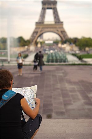
Couple sitting at a sidewalk cafe and reading a map, Paris, Ile-de-France, France
Premium Royalty-Free
-
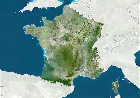
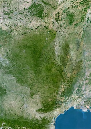
Satellite view of Aquitaine, France. This image was compiled from data acquired by LANDSAT 5 & 7 satellites.
Rights-Managed
-

Man reading a map with a woman pointing, Terrasse De l'Orangerie, Jardin des Tuileries, Paris, Ile-de-France, France
Premium Royalty-Free
-
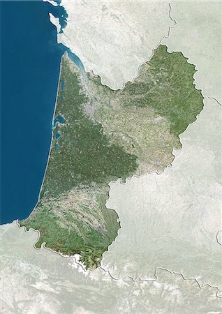
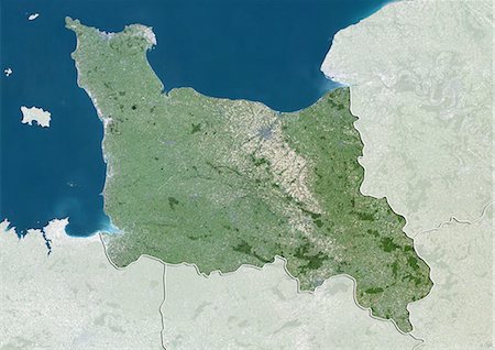
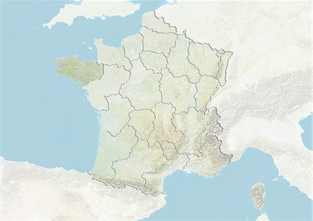
Relief map of Lower Normandy, France. This image was compiled from data acquired by LANDSAT 5 & 7 satellites combined with elevation data.
Rights-Managed
-

-

Couple reading a map in a garden, Terrasse De l'Orangerie, Jardin des Tuileries, Paris, Ile-de-France, France
Premium Royalty-Free
-
-

-

Relief map of Lower Normandy, France. This image was compiled from data acquired by LANDSAT 5 & 7 satellites combined with elevation data.
Rights-Managed
-

Man sitting at a sidewalk cafe and reading a map, Paris, Ile-de-France, France
Premium Royalty-Free
-

-

-

-
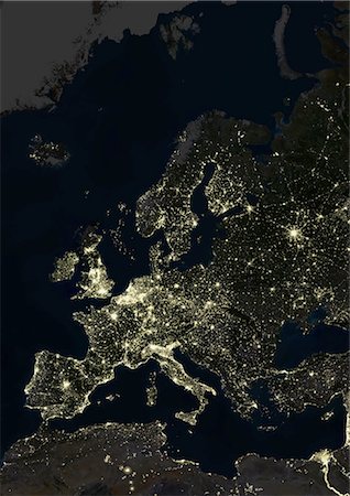
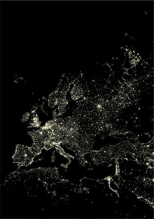
Europe At Night, True Colour Satellite Image. True colour satellite image of Europe at night. This image in Lambert Conformal Conic projection was compiled from data acquired by LANDSAT 5 & 7 satellites.
Rights-Managed
-
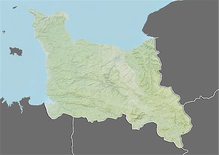
Satellite view of Lower Normandy, France. This image was compiled from data acquired by LANDSAT 5 & 7 satellites.
Rights-Managed
-

-

Couple with bicycles looking at a map, Paris, Ile-de-France, France
Premium Royalty-Free
-

-

-

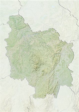
Relief map of Auvergne, France. This image was compiled from data acquired by LANDSAT 5 & 7 satellites combined with elevation data.
Rights-Managed
-

-

-

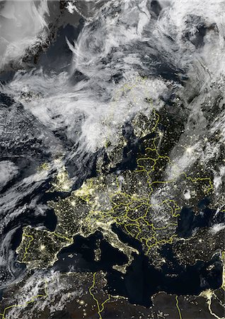
Europe At Night With Country Borders, True Colour Satellite Image. True colour satellite image of Europe at night with country borders. This image in Lambert Conformal Conic projection was compiled from data acquired by LANDSAT 5 & 7 satellites.
Rights-Managed
-

-

Couple sitting at a sidewalk cafe and reading a map, Paris, Ile-de-France, France
Premium Royalty-Free
-
-

-

-

-

Man looking a map in a ticket machine, Paris, Ile-de-France, France
Premium Royalty-Free
-

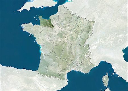
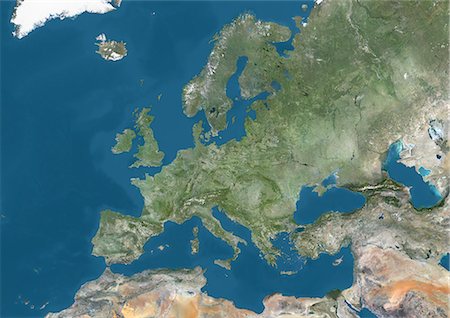
Europe, True Colour Satellite Image. True colour satellite image of Europe. This image in Lambert Conformal Conic projection was compiled from data acquired by LANDSAT 5 & 7 satellites.
Rights-Managed
-

Mediterranean Area, True Colour Satellite Image. Mediterranean Sea. True colour satellite images showing the Mediterranean Sea. Points of interest include the Alps (just above centre, white), the Blakek Sea (centre right), and the Nile Delta (green, lower right). This image was compiled from data acquired by LANDSAT 5 & 7 satellites.
Rights-Managed
-

Man sitting on the suitcase and reading a map, Paris, Ile-de-France, France
Premium Royalty-Free
-

Satellite view of Alsace, France. This image was compiled from data acquired by LANDSAT 5 & 7 satellites.
Rights-Managed
-

-

Man looking a map in a ticket machine, Paris, Ile-de-France, France
Premium Royalty-Free
-

-

-
-

Beach Ball Globe in Swimming Pool, Sanary-sur-Mer, Var, Provence, Provence-Alpes-Cote d'Azur, France
Premium Royalty-Free
-

Avignon, France, True Colour Satellite Image. Avignon, France. True colour satellite image of the city of Avignon. Composite of 2 images, taken on 21 July 2001 and 22 June 2002, by LANDSAT 7.
Rights-Managed
-
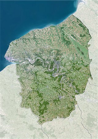
Satellite view of Upper Normandy, France. This image was compiled from data acquired by LANDSAT 5 & 7 satellites.
Rights-Managed
-

-

-

-

Man reading a map with a woman pointing, Terrasse De l'Orangerie, Jardin des Tuileries, Paris, Ile-de-France, France
Premium Royalty-Free
-

-

Couple with bicycles looking at a map, Paris, Ile-de-France, France
Premium Royalty-Free
-
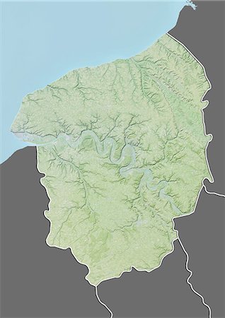
Relief map of Upper Normandy, France. This image was compiled from data acquired by LANDSAT 5 & 7 satellites combined with elevation data.
Rights-Managed
-

Woman Holding Inflatable Globe, Sanary-sur-Mer, Var, Provence, Provence-Alpes-Cote d'Azur, France
Premium Royalty-Free
-
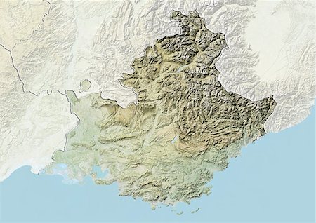
Relief map of Provence-Alpes-Cote d'Azur, France. This image was compiled from data acquired by LANDSAT 5 & 7 satellites combined with elevation data.
Rights-Managed
-

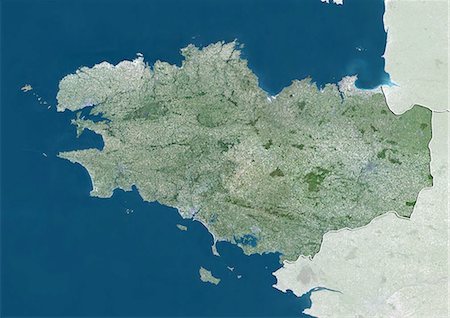
Relief map of Brittany, France. This image was compiled from data acquired by LANDSAT 5 & 7 satellites combined with elevation data.
Rights-Managed
-
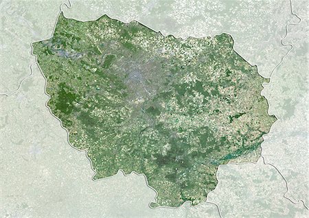
Satellite view of Ile-de-France, France. This image was compiled from data acquired by LANDSAT 5 & 7 satellites.
Rights-Managed
-

Europe With Cloud Coverage, True Colour Satellite Image. True colour satellite image of Europe with cloud coverage. This image in Lambert Conformal Conic projection was compiled from data acquired by LANDSAT 5 & 7 satellites.
Rights-Managed
-
Relief map of Burgundy, France. This image was compiled from data acquired by LANDSAT 5 & 7 satellites combined with elevation data.
Rights-Managed
-
-

Basque Country, France-Spain, True Colour Satellite Image. Basque Country, France - Spain. True colour satellite image of the Basque Country, a region in the western Pyrenees mountains that goes across the border between France and Spain. This image was compiled from data acquired by LANDSAT 5 & 7 satellites.
Rights-Managed
-

Cherbourg, France, True Colour Satellite Image. Cherbourg, France. True colour satellite image of the city of Cherbourg, taken on 12 May 2002, using LANDSAT 7 data.
Rights-Managed
-

-

Relief map of Brittany, France. This image was compiled from data acquired by LANDSAT 5 & 7 satellites combined with elevation data.
Rights-Managed
-

Couple holding a map in front of their faces, Terrasse De l'Orangerie, Jardin des Tuileries, Paris, Ile-de-France, France
Premium Royalty-Free
-
Massif Central Region, France, True Colour Satellite Image. Massif Central region, France, true colour satellite image. This image was compiled from data acquired by LANDSAT 5 & 7 satellites.
Rights-Managed
-
Western Europe At Night, Satellite Image. Lights of Western Europe at night from space. Coloured image derived from satellite data showing Western Europe at night. This image is a mosaic of frames made at night by US Defense Meteorological Satellite Program (DMSP).
Rights-Managed
-

Marseille, France, True Colour Satellite Image. Marseille, France. True colour satellite image of the city of Marseille, taken on 21 July 2001, using LANDSAT 7 data.
Rights-Managed
-

-
Europe With Country Borders And Major Rivers, True Colour Satellite Image. True colour satellite image of Europe with country borders and major rivers. This image in Lambert Conformal Conic projection was compiled from data acquired by LANDSAT 5 & 7 satellites.
Rights-Managed
-

-

-

-

Re And Oleron Islands, France, True Colour Satellite Image. Ré & Oleron Islands, France. True colour satellite image of Ré & Oléron islands, that are off the west coast of France near La Rochelle. This image was compiled from data acquired by LANDSAT 5 & 7 satellites.
Rights-Managed
-
Reims, France, True Colour Satellite Image. Reims, France. True colour satellite image of the city of Reims, taken on 2 July 2001, using LANDSAT 7 data.
Rights-Managed
-

Picardie Region, France, True Colour Satellite Image With Mask. Picardie region, France, true colour satellite image with mask. This image was compiled from data acquired by LANDSAT 5 & 7 satellites.
Rights-Managed
-

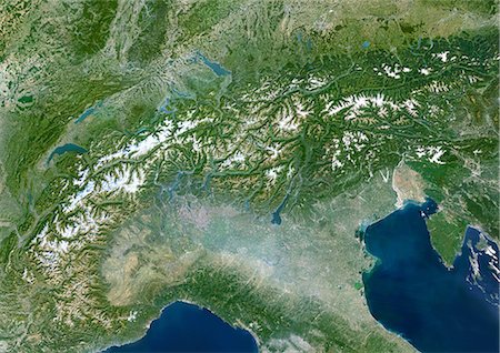
Lake Leman, Europe, True Colour Satellite Image. True colour satellite image of Lake Léman, the largest natural freshwater lake in western Europe. It is divided between two countries : France and Switzerland. Image taken on 21 July 2001, using LANDSAT 7 data.
Rights-Managed
-

-

Lyon, France, True Colour Satellite Image. Lyon, France. True colour satellite image of the city of Lyon, taken on 21 July 2001, using LANDSAT 7 data.
Rights-Managed
-
Satellite view of Brittany, France. This image was compiled from data acquired by LANDSAT 5 & 7 satellites.
Rights-Managed
-
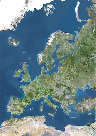
Satellite view of Europe. This image was compiled from data acquired by Landsat 7 & 8 satellites.
Rights-Managed
-
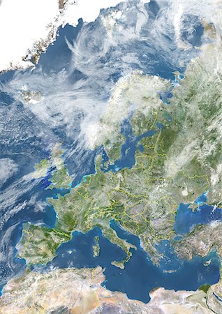
Europe With Country Borders And Cloud Coverage, True Colour Satellite Image. True colour satellite image of Europe with country borders and cloud coverage. This image in Lambert Conformal Conic projection was compiled from data acquired by LANDSAT 5 & 7 satellites.
Rights-Managed
-

-

Europe At Night With Cloud Coverage, True Colour Satellite Image. True colour satellite image of Europe at night with cloud coverage. This image in Lambert Conformal Conic projection was compiled from data acquired by LANDSAT 5 & 7 satellites.
Rights-Managed
-

Haute-Normandie Region, France, True Colour Satellite Image With Mask. Haute Normandie region, France, true colour satellite image with mask. This image was compiled from data acquired by LANDSAT 5 & 7 satellites.
Rights-Managed
-
-

-
-

-

-
Europe At Night With Country Borders And Cloud Coverage, True Colour Satellite Image. True colour satellite image of Europe at night with country borders and cloud coverage. This image in Lambert Conformal Conic projection was compiled from data acquired by LANDSAT 5 & 7 satellites.
Rights-Managed


